
How to Cite


Share
Copyright (c) 2023 Margaret Dolan, Lilja Rún Bjarnadóttir

This work is licensed under a Creative Commons Attribution 4.0 International License.
Abstract
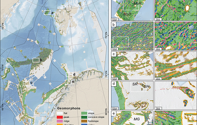
Morphometric diversity is an important component of overall seabed geodiversity. Automated methods for classification of morphometric features (ridges, peaks, valleys etc.) provide a convenient way of classifying large volumes of data in a consistent and repeatable way and a basis for assessing morphometric diversity. Here, we apply ‘geomorphons’, a pattern recognition approach to morphometric feature classification, to 100 m resolution multibeam bathymetry data in the Barents and Norwegian Seas, Norway. The study area spans depths from a few metres to nearly 6000 m across several geological settings. Ten unique morphometric features are delineated by the geomorphon analysis. From these results, we compute the variety of features per 10 km2. This simple ‘geomorphon richness’ measure highlights broad-scale morphometric diversity across the study area. We compare the richness results with terrain attributes and across physiographic regions. Our results provide new regional insights, which together with more detailed information will help guide follow-up surveys as well as identifying diversity hotspots, which may require special management.
How to Cite
Share
Copyright (c) 2023 Margaret Dolan, Lilja Rún Bjarnadóttir
This work is licensed under a Creative Commons Attribution 4.0 International License.
Downloads
Guest editors: Kaskela Anu (Geological Survey of Finland), Margaret Dolan (Geological Survey of Norway) and Verner Brandbyge Ernstsen (Geological Survey of Denmark and Greenland).
This special issue highlights the application and development of the concepts of geodiversity and geosystem services in a marine context with a specific focus on the Scandinavian [...]
References
- Bailey, J.J., Boyd, D.S., Hjort, J., Lavers, C.P. & Field, R. 2017: Modelling native and alien vascular plant species richness: At which scales is geodiversity most relevant? Global Ecology and Biogeography 26(7), 763–776. https://doi.org/10.1111/geb.12574
- Bøe, R., Bjarnadóttir, L.R., Elvenes, S., Dolan, M., Bellec, V., Thorsnes, T., Lepland, A. & Longva, O. 2020: Revealing the secrets of Norway’s seafloor – geological mapping within the MAREANO programme and in coastal areas. Geological Society, London, Special Publications 505, 57–59. https://doi.org/10.1144/sp505-2019-82
- Dekavalla, M. & Argialas, D. 2017: Object-based classification of global undersea topography and geomorphological features from the SRTM30_PLUS data. Geomorphology 288, 66–82. https://doi.org/10.1016/j.geomorph.2017.03.026
- Di Stefano, M. & Mayer, L.A. 2018: An automatic procedure for the quantitative characterization of submarine bedforms. Geosciences 8(1), 28. https://doi.org/10.3390/geosciences8010028
- Dikau, R. 1989: The application of a digital relief model to landform analysis. In: Raper, J.F. (ed.): Three dimensional applications in Geographical Information Systems. 51–77. Taylor and Francis.
- Dolan, M.F.J., Bøe, R. & Bjarnadóttir, L.R. 2022: Delivering seabed geodiversity information through multidisciplinary mapping initiatives: experiences from Norway. GEUS Bulletin 52, 8325. https://doi.org/10.34194/geusb.v52.8325
- Dove, D. et al. 2016: Seabed geomorphology: a two-part classification system. OR/16/001. Unpublished report, British Geological Survey, UK. http://nora.nerc.ac.uk/id/eprint/514946 (accessed November 2022).
- Dove, D. et al. 2020: A two-part seabed geomorphology classification scheme (v.2); part 1: morphology features glossary. https://doi.org/10.5281/zenodo.4075248
- Elvenes, I.S. 2014: Landscape Mapping in MAREANO. NGU Report 2013.035. 40 pp. Institutional report, Geological Survey of Norway, Trondheim. https://www.ngu.no/upload/Publikasjoner/Rapporter/2013/2013_035.pdf
- Evans, I.S. 2012: Geomorphometry and landform mapping: What is a landform? Geomorphology 137(1), 94–106. https://doi.org/10.1016/j.geomorph.2010.09.029
- Evans, J.S. 2020: _spatialEco_. R package version 1.34. https://github.com/jeffreyevans/spatialEco
- Federal Geographic Data Committee. 2012: Coastal and marine ecological classification standard version 4.0. 339 pp. https://www.fgdc.gov/standards/projects/cmecs-folder/CMECS_Version-_4_Final_for_FGDC-20120111.pdf (accessed Novemer 2022).
- Fisher, P., Wood, J. & Cheng, T. 2004: Where is Helvellyn? Fuzziness of multi-scale landscape morphometry. Transactions of the Institute of British Geographers 29(1), 106–128.
- Gray, M. 2004: Geodiversity: valuing and conserving abiotic nature. 512 pp. Chichester, UK: John Wiley & Sons.
- GEBCO Bathymetric Compilation Group: 2019. The GEBCO_2019 Grid – a continuous terrain model of the global oceans and land. British Oceanographic Data Centre, National Oceanography Centre, NERC, UK. https://doi.org/10.5285/836f016a-33be-6ddc-e053-6c86abc0788e
- Jasiewicz, J. & Stepinski, T.F. 2013: Geomorphons – a pattern recognition approach to classification and mapping of landforms. Geomorphology 182, 147–156. https://doi.org/10.1016/j.geomorph.2012.11.005
- Lecours, V., Dolan, M.F.J., Micallef, A. & Lucieer, V.L. 2016: A review of marine geomorphometry, the quantitative study of the seafloor. Hydrology and Earth System Sciences 20(8), 3207–3244. https://doi.org/10.5194/hess-20-3207-2016
- MacMillan, R.A. & Shary, P.A. 2009: Chapter 9 landforms and landform elements in geomorphometry. In: Hengl, T. & Reuter, H.I. (eds): Developments in soil science 33, 227–254. Elsevier. https://doi.org/10.1016/S0166-2481(08)00009-3
- Masetti, G. 2022: BRESS v.2.3. https://www.hydroffice.org/bress/main
- Masetti, G., Mayer, L.A. & Ward, L.G. 2018: A bathymetry- and reflectivity-based approach for seafloor segmentation. Geosciences 8(1), 14. https://doi.org/10.3390/geosciences8010014
- Nanson, R.A., Borissova, I., Huang, Z., Post, A., Nichol, S.L., Spinoccia, M., Siwabessy, J.W., Sikes, E.L. & Picard, K. 2022: Cretaceous to Cenozoic controls on the genesis of the shelf-incising Perth Canyon; insights from a two-part geomorphology mapping approach. Marine Geology 445, 106731. https://doi.org/10.1016/j.margeo.2022.106731
- Nanson, R. et al. 2023: A two-part seabed geomorphology classification scheme; Part 2: Geomorphology classification framework and glossary (Version 1.0). Zenodo. https://doi.org/10.5281/zenodo.7804019
- Novaczek, E., Devillers, R. & Edinger, E. 2019: Generating higher resolution regional seafloor maps from crowd-sourced bathymetry. PLoS One 14(6), e0216792. https://doi.org/10.1371/journal.pone.0216792
- Pál, M. & Albert, G. 2021: The use of geomorphons in geodiversity assessment. EGU General Assembly 2021, online, 19–30 Apr 2021, EGU21-1363. https://doi.org/10.5194/egusphere-egu21-1363
- Sappington, J.M., Longshore, K.M. & Thompson, D.B. 2007: Quantifying landscape ruggedness for animal habitat analysis: A case study using bighorn sheep in the Mojave Desert. Journal of Wildlife Management 71(5), 1419–1426. https://doi.org/10.2193/2005-723
- Schmidt, J. & Andrew, R. 2005: Multi-scale landform characterization. Area 37(3), 341–350. https://doi.org/10.1111/j.1475-4762.2005.00638.x
- Schrodt, F. et al. 2019: To advance sustainable stewardship, we must document not only biodiversity but geodiversity. Proceedings of the National Academy of Sciences 116(33), 16155–16158. https://doi.org/10.1073/pnas.1911799116
- Sowers, D.C., Masetti, G., Mayer, L.A., Johnson, P., Gardner, J.V. & Armstrong, A.A. 2020: Standardized geomorphic classification of seafloor within the United States Atlantic canyons and continental margin. Frontiers in Marine Science 7, 9. https://doi.org/10.3389/fmars.2020.00009
- Tukiainen, H. & Bailey, J.J. 2022: Enhancing global nature conservation by integrating geodiversity in policy and practice. Conservation Biology 37, e14024. https://doi.org/10.1111/cobi.14024
- Vörös, F., Pál, M., van Wyk de Vries, B. & Székely, B. 2021: Development of a new type of geodiversity system for the scoria cones of the Chaîne des Puys based on geomorphometric studies. Geosciences 11(2), 58. https://doi.org/10.3390/geosciences11020058
- Wood, J. 1996: The geomorphological characterisation of digital elevation models. University of Leicester. Thesis. https://hdl.handle.net/2381/34503 (accessed November 2022)

