
How to Cite


Share
Copyright (c) 2022 Margaret Dolan, Reidulv Bøe, Lilja Rún Bjarnadóttir

This work is licensed under a Creative Commons Attribution 4.0 International License.
Abstract
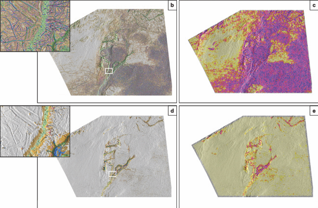
Geology is a core component of two major multidisciplinary seabed-mapping initiatives in Norway (MAREANO, Marine Base Maps for the Coastal Zone). Helped by Norway’s Nature Diversity Act, which acknowledges geological and landscape diversity alongside biodiversity, geological information has gained recognition nationally as part of an essential foundation for knowledge-based management, both in the coastal zone and offshore. Recently, international focus on the United Nations Sustainable Development Goals has led to the proposal of Essential Geodiversity Variables, a framework for geological (geodiversity) information, intended to stand alongside Essential Variables already defined for climate, biodiversity and oceans (limited to ocean physics, biochemistry, biology, and ecosystems). Here we examine to what extent map products from the Geological Survey of Norway generated under these multidisciplinary mapping initiatives fit within this framework of Essential Geodiversity Variables and how well it is suited to information on marine geodiversity. Although we conclude that the framework is generally a good fit for the marine-relevant Essential Geodiversity Variable classes (geology and geomorphology), we examine opportunities for further highlighting quantitative geodiversity information. We present preliminary examples of substrate diversity and morphological diversity and discuss our experience of geological mapping as part of multidisciplinary initiatives. We highlight many benefits, which far outweigh any perceived or real compromises of this approach in monetary, practical and scientific terms.
How to Cite
Share
Copyright (c) 2022 Margaret Dolan, Reidulv Bøe, Lilja Rún Bjarnadóttir
This work is licensed under a Creative Commons Attribution 4.0 International License.
Supplementary Files
Funding
This study was supported by The Geological Survey of Norway and draws on results from the MAREANO programme and the Marine Base Maps for the Coastal Zone pilot project.Downloads
Guest editors: Kaskela Anu (Geological Survey of Finland), Margaret Dolan (Geological Survey of Norway) and Verner Brandbyge Ernstsen (Geological Survey of Denmark and Greenland).
This special issue highlights the application and development of the concepts of geodiversity and geosystem services in a marine context with a specific focus on the Scandinavian [...]
References
- Bailey, J.J., Boyd, D.S., Hjort, J., Lavers, C.P. & Field, R. 2017: Modelling native and alien vascular plant species richness: at which scales is geodiversity most relevant? Global Ecology and Biogeography 26(7), 763–776. https://doi.org/10.1111/geb.12574
- Bekkby, T., Bodvin, T., Bøe, R., Moy, F.E., Olsen, H. & Rinde, E. 2011: Nasjonalt program for kartlegging og overvåking av biologisk mangfold-marint. Sluttrapport for perioden 2007–2010. http://hdl.handle.net/11250/215287 (accessed June 2022).
- Bellec, V.K., Bøe, R., Rise, L., Lepland, A., Thorsnes, T. & Bjarnadóttir, L.R. 2017: Seabed sediments (grain size) of Nordland VI, offshore north Norway. Journal of Maps 13(2), 608–620. https://doi.org/10.1080/17445647.2017.1348307
- Bjarnadóttir, L., Ottesen, D., Dowdeswell, J. & Bugge, T. 2016: Unusual iceberg ploughmarks on the Norwegian continental shelf. Geological Society, London, Memoirs 46(1), 283–284. https://doi.org/10.1144/m46.126
- Bojinski, S., Verstraete, M., Peterson, T.C., Richter, C., Simmons, A. & Zemp, M. 2014: The concept of essential climate variables in support of climate research, applications, and policy. Bulletin of the American Meteorological Society 95(9), 1431–1443. https://doi.org/10.1175/bams-d-13-00047.1
- Bøe, R., Bjarnadóttir, L.R., Elvenes, S., Dolan, M., Bellec, V., Thorsnes, T., Lepland, A. & Longva, O. 2020: Revealing the secrets of Norway’s seafloor – geological mapping within the MAREANO programme and in coastal areas. Geological Society, London, Special Publications 505, 57–69. https://doi.org/10.1144/SP505-2019-82
- Bøe, R., Elvenes, S., Totland, O., Olsen, H., Lepland, A., Thorsnes, T. & Dolan, M. 2010: Standard for geological seabed mapping offshore. NGU report. 15 pp. https://www.ngu.no/upload/Publikasjoner/Rapporter/2010/2010_033.pdf (accessed June 2022).
- Brilha, J., Gray, M., Pereira, D.I. & Pereira, P. 2018: Geodiversity: an integrative review as a contribution to the sustainable management of the whole of nature. Environmental Science & Policy 86, 19–28. https://doi.org/10.1016/j.envsci.2018.05.001
- Chakraborty, A. & Gray, M. 2020: A call for mainstreaming geodiversity in nature conservation research and praxis. Journal for Nature Conservation 56, 125862. https://doi.org/10.1016/j.jnc.2020.125862
- Diesing, M. 2020: Deep-sea sediments of the global ocean. Earth System Science Data 12(4), 3367–3381. https://doi.org/10.5194/essd-12-3367-2020
- Direktoratet for naturforvaltning. 2007: Kartlegging av marint biologisk mangfold. DN Håndbok 19–2001 (Revidert 2007). 51pp. https://www.miljodirektoratet.no/publikasjoner/publikasjoner-fra-dirnat/dn-handboker/kartlegging-av-marint-biologisk-mangfold/ (accessed June 2022).
- Dolan, M.F.J., Ross, R.E., Albretsen, J., Skarðhamar, J., Gonzalez-Mirelis, G., Bellec, V.K., Buhl-Mortensen, P. & Bjarnadottir, L.R. 2021: Using spatial validity and uncertainty metrics to determine the relative suitability of alternative suites of oceanographic data for seabed biotope prediction. A case study from the Barents Sea, Norway. Geosciences 11(2). 48. https://doi.org/10.3390/geosciences11020048
- Dove, D. et al. 2016: Seabed geomorphology: a two-part classification system. OR/16/001. Unpublished report, British Geological Survey, UK. http://nora.nerc.ac.uk/id/eprint/514946 (accessed June 2022).
- Dove, D. et al. 2020: A two-part seabed geomorphology classification scheme (v.2); part 1: morphology features glossary. https://doi.org/10.5281/zenodo.4075248
- Elvenes, S., Bøe, R., Lepland, A. & Dolan, M. 2019: Seabed sediments of Sore Sunnmore, Norway. Journal of Maps 15(2), 686–696. https://doi.org/10.1080/17445647.2019.1659865
- Erikstad, L. 2013: Geoheritage and geodiversity management – the questions for tomorrow. Proceedings of the Geologists Association 124(4), 713–719. https://doi.org/10.1016/j.pgeola.2012.07.003
- Federal Geographic Data Committee. 2012: Coastal and marine ecological classification standard version 4.0. 339 pp. https://www.fgdc.gov/standards/projects/cmecs-folder/CMECS_Version-_4_Final_for_FGDC-20120111.pdf (accessed June 2022).
- Fisher, P., Wood, J. & Cheng, T. 2004: Where is Helvellyn? Fuzziness of multi-scale landscape morphometry. Transactions of the Institute of British Geographers 29(1), 106–128. https://doi.org/10.1111/j.0020-2754.2004.00117.x
- Geological Survey of Norway. 2022: Produktspesifikasjon: Bunnsedimenter (kornstørrelse) 1.1. https://register.geonorge.no/register/versjoner/produktspesifikasjoner/norges-geologiske-unders%C3%B8kelse/bunnsedimenter-kornst%C3%B8rrelse (accessed June 2022).
- Global Ocean Observing System. 2022: Essential ocean variables. https://www.goosocean.org/index.php?option=com_content&view=article&id=14&Itemid=114 (accessed June 2022).
- Gray, M. 2004: Geodiversity: valuing and conserving abiotic nature. 512 pp. John Wiley & Sons, Chichester, UK.
- Gray, M. 2011: Other nature: geodiversity and geosystem services. Environmental Conservation 38(3), 271–274. https://doi.org/10.1017/s0376892911000117
- Gray, M. 2012: Valuing geodiversity in an ‘ecosystem services’ context. Scottish Geographical Journal 128(3–4), 177–194. https://doi.org/10.1080/14702541.2012.725858
- Gray, M. 2021: Geodiversity: a significant, multi-faceted and evolving, geoscientific paradigm rather than a redundant term. Proceedings of the Geologists Association 132(5), 605–619. https://doi.org/10.1016/j.pgeola.2021.09.001
- Greene, H.G., Yoklavich, M.M., Starr, R.M., O’Connell, V.M., Wakefield, W.W., Sullivan, D.E., McRea, J.E., Jr. & Cailliet, G.M. 1999: A classification scheme for deep seafloor habitats. Oceanologica Acta 22(6), 663–678. https://doi.org/10.1016/s0399-1784(00)88957-4
- Halvorsen, R., medarbeidere & samarbeidspartnere. 2016: NiN – typeinndeling og beskrivelsessystem for natursystemnivået – Natur i Norge, Artikkel 3 (versjon 2.1.0). 1–528. Trondheim: Artsdatabanken. http://www.artsdatabanken.no (accessed June 2022).
- Halvorsen, R., Skarpaas, O., Bryn, A., Bratli, H., Erikstad, L., Simensen, T. & Lieungh, E. 2020: Towards a systematics of ecodiversity: the EcoSyst framework. Global Ecology and Biogeography 29(11), 1887–1906. https://doi.org/10.1111/geb.13164
- Hengl, T. et al. 2017: SoilGrids250m: global gridded soil information based on machine learning. PLoS One 12(2), e0169748. https://doi.org/10.1371/journal.pone.0169748
- Hjort, J., Heikkinen, R.K. & Luoto, M. 2012: Inclusion of explicit measures of geodiversity improve biodiversity models in a boreal landscape. Biodiversity and Conservation 21(13), 3487–3506. https://doi.org/10.1007/s10531-012-0376-1
- Jasiewicz, J. & Stepinski, T.F. 2013: Geomorphons – a pattern recognition approach to classification and mapping of landforms. Geomorphology 182, 147–156. https://doi.org/10.1016/j.geomorph.2012.11.005
- Johansson, C.E. (ed). 2001: Geodiversitet i Nordisk Naturvård 8. Nordic Council of Ministers.
- Kaskela, A.M. & Kotilainen, A.T. 2017: Seabed geodiversity in a glaciated shelf area, the Baltic Sea. Geomorphology 295, 419–435. https://doi.org/10.1016/j.geomorph.2017.07.014
- Kaskela, A.M. et al. 2019: Picking up the pieces harmonising and collating seabed substrate data for European maritime areas. Geosciences 9(2). 84. https://doi.org/10.3390/geosciences9020084
- Laverick, J.H., Speirs, D.C. & Heath, M.R. 2022: Synthetic shelf sediment maps for the Greenland Sea and Barents Sea. Geoscience Data Journal 00, 1–11. https://doi.org/10.1002/gdj3.154
- Lecours, V., Devillers, R., Edinger, E.N., Brown, C.J. & Lucieer, V.L. 2017a: Influence of artefacts in marine digital terrain models on habitat maps and species distribution models: a multiscale assessment. Remote Sensing in Ecology and Conservation 3(4), 232–246. https://doi.org/10.1002/rse2.49
- Lecours, V., Devillers, R., Lucieer, V.L. & Brown, C.J. 2017b: Artefacts in marine digital terrain models: a multiscale analysis of their impact on the derivation of terrain attributes. IEEE Transactions on Geoscience and Remote Sensing 55(9), 5391–5406. https://doi.org/10.1109/tgrs.2017.2707303
- Lepland, A., Rybalko, A. & Lepland, A. 2014: Seabed sediments of the barents sea. Scale 1:3 000 000. Trondheim: Geological Survey of Norway & SEVMORGEO. In Bunnsedimenter (kornstørrelse), oversikt https://kartkatalog.geonorge.no/metadata/norges-geologiske-undersokelse/bunnsedimenter-kornstorrelse-oversikt/39c357fc-8c56-49e0-a6ba-3e434d62a585 (accessed June 2022).
- Lurton, X. & Lamarche, G. (eds). 2015: Backscatter measurements by seafloor-mapping sonars. Guidelines and recommendations. https://geohab.org/publications/ (accessed June 2022).
- Masetti, G., Mayer, L.A. & Ward, L.G. 2018: A bathymetry- and reflectivity-based approach for seafloor segmentation. Geosciences 8(1), 14. https://doi.org/10.3390/geosciences8010014
- Milton, K. 2002: Loving nature: towards an ecology of emotion. Routledge, London.
- Ministry of Climate and Environment. 2009: Nature Diversity Act. Act of 19 June 2009 No.100 relating to the management of biological, geological and landscape diversity. https://www.regjeringen.no/en/dokumenter/nature-diversity-act/id570549/ (accessed June 2022).
- Nanson, R.A., Borissova, I., Huang, Z., Post, A., Nichol, S.L., Spinoccia, M., Siwabessy, J.W., Sikes, E.L. & Picard, K. 2022: Cretaceous to cenozoic controls on the genesis of the shelf-incising Perth Canyon; insights from a two-part geomorphology mapping approach. Marine Geology 445, 106731. https://doi.org/10.1016/j.margeo.2022.106731
- Norwegian Biodiversity Information Centre. 2022: S3F Finmaterialinnhold (i sorterte sedimenter). https://www.artsdatabanken.no/Pages/179772/Finmaterialinnhold__i_sorterte_sedimenter_ (accessed June 2022).
- Pellitero, R., Manosso, F.C. & Serrano, E. 2015: Mid- and large-scale geodiversity calculation in Fuentes Carrionas (NW Spain) and Serra do Cadeado (Parana, Brazil): methodology and application for land management. Geografiska Annaler Series a-Physical Geography 97(2), 219–235. https://doi.org/10.1111/geoa.12057
- Read, Q.D. et al. 2020: Beyond counts and averages: relating geodiversity to dimensions of biodiversity. Global Ecology and Biogeography 29(4), 696–710. https://doi.org/10.1111/geb.13061
- Rise, L., Bellec, V.K., Chand, S. & Bøe, R. 2014: Pockmarks in the southwestern Barents Sea and Finn mark fjords. Norwegian Journal of Geology 94(4), 263–282. https://njg.geologi.no/images/NJG_articles/NJG4_Vol94_4_Rise_Scr.pdf (accessed June 2022).
- Ruppel, C.D. & Kessler, J.D. 2017: The interaction of climate change and methane hydrates. Reviews of Geophysics 55(1), 126–168. https://doi.org/10.1002/2016rg000534
- Schrodt, F. et al. 2019: To advance sustainable stewardship, we must document not only biodiversity but geodiversity. Proceedings of the National Academy of Sciences 116(33), 16155–16158. https://doi.org/10.1073/pnas.1911799116
- Sharples, C. 1993: A methodology for the identification of significant landforms and geological sites for geoconservation purposes. Tasmania: Forestry Commission.
- Sowers, D.C., Masetti, G., Mayer, L.A., Johnson, P., Gardner, J.V. & Armstrong, A.A. 2020: Standardized geomorphic classification of seafloor within the United States Atlantic Canyons and Continental Margin. Frontiers in Marine Science 7, 9. https://doi.org/10.3389/fmars.2020.00009
- Tukiainen, H., Alahuhta, J., Ala-Hulkko, T., Field, R., Lampinen, R. & Hjort, J. 2016: Contribution of geodiversity, climate and spatial variables for biodiversity across a gradient of human influence. Geophysical Research Abstracts Vol. 18, EGU2016-184, 2016, EGU General Assembly 2016.
- Vallius, H.T., Kotilainen, A.T., Asch, K.C., Fiorentino, A., Judge, M., Stewart, H.A. & Pjetursson, B. 2020: Discovering Europe’s seabed geology: the EMODnet concept of uniform collection and harmonization of marine data. Geological Society, London, Special Publications 505(1), SP505-2019-208. https://doi.org/10.1144/sp505-2019-208
- van Son, T.C., Dolan, M., Gonzales-Mirelis, G., Thorsnes, T., Bjarnadóttir, L.R. & Buhl-Mortensen, P. 2015: Environmental variability index (EVI) – a MAREANO methods study for guidance of sampling effort. NGU report. https://www.ngu.no/upload/Publikasjoner/Rapporter/2015/2015_027.pdf (accessed June 2022).
- van Son, T.C., Nikolioudakis, N., Steen, H., Albretsen, J., Furevik, B.R., Elvenes, S., Moy, F. & Norderhaug, K.M. 2020: Achieving reliable estimates of the spatial distribution of kelp biomass. Frontiers in Marine Science 7, 107. https://doi.org/10.3389/fmars.2020.00107
- Wiedenbein, F. 1993: Ein Geotopschutzkonzept für Deutschland. Geotopschutz, probleme der methodik und der praktischen umsetzung, 1. Jahrestagung der AG Geotopschutz, Otzenhausen/Saarland, 17. Saarbrucken: University de Saarlandes.
- Wilson, M.F.J., O’Connell, B., Brown, C., Guinan, J.C. & Grehan, A.J. 2007: Multiscale terrain analysis of multibeam bathymetry data for habitat mapping on the continental slope. Marine Geodesy 30(1), 3–35. https://doi.org/10.1080/01490410701295962
- Wyles, H.M.E., Boehme, L., Russell, D.J. & Carter, M.I. 2022: A novel approach to using seabed geomorphology as a predictor of habitat use in highly mobile marine predators: implications for ecology and conservation. Frontiers in Marine Science 9, 1. https://doi.org/10.3389/fmars.2022.818635

