
How to Cite


Share
Copyright (c) 2024 Anu M Kaskela, Aarno T Kotilainen

This work is licensed under a Creative Commons Attribution 4.0 International License.
Abstract
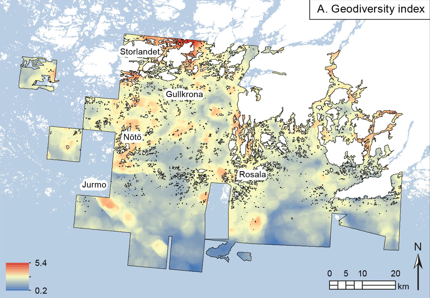
This study investigated the geodiversity of the Archipelago Sea in the northern Baltic Sea, focusing on geological features and their spatial distribution. By adapting methods used in previous Baltic Sea studies, we conducted spatial analyses of geological data sets including bedrock type, seabed substrates and seabed structures. Bedrock and substrate data were freely available, while seabed structures were modelled from bathymetry data. Geodiversity was quantified using a geodiversity index, which considers the variety of physical elements, roughness and area of the unit. The analyses revealed a diverse seabed environment in the Archipelago Sea with varying geodiversity throughout the study area. Significant features contributing to geodiversity included bedrock fracture and fault zones and large end-moraine formations. Similar patterns have been observed in terrestrial areas of Finland. The analyses also detected relations between archipelago zonation and geodiversity with areas of open sea more homogeneous than the middle and inner archipelago. This study formally recognises the complexity of the seabed in the Archipelago Sea and highlights the importance of understanding the geological processes shaping the region. The results can inform maritime spatial planning and sustainable resource management.
How to Cite
Share
Copyright (c) 2024 Anu M Kaskela, Aarno T Kotilainen
This work is licensed under a Creative Commons Attribution 4.0 International License.
Supplementary Files
Funding
This study was funded by Geological Survey of Finland, the projects EMODnet (EASME/EMFF/2020/3.1.11/Lot2/SI2.853812_EMODnet – Geology 5.2) and MAAMERI as well as the FINMARI network and the VELMU programme. The study also supports implementation of the project LIFE-IP Biodiversea (LIFE20 IPE/Fl/000020). The project has received funding from the LIFE Programme of the European Union. The material reflects the views by the authors, and the European Commission or the CINEA is not responsible for any use that may be made of the information it contains.Downloads
Guest editors: Kaskela Anu (Geological Survey of Finland), Margaret Dolan (Geological Survey of Norway) and Verner Brandbyge Ernstsen (Geological Survey of Denmark and Greenland).
This special issue highlights the application and development of the concepts of geodiversity and geosystem services in a marine context with a specific focus on the Scandinavian [...]
References
- Bourassa, S.C. 1992: The aesthetics of landscape. London: Bellhaven Press.
- Crisp, J.R., Ellison, J.C. & Fischer, A. 2021: Current trends and future directions in quantitative geodiversity assessment. Progress in Physical Geography: Earth and Environment 45(4), 514–540. https://doi.org/10.1177/0309133320967219
- Crofts, R. 2014: Promoting geodiversity: learning lessons from biodiversity. Proceedings of the Geologists’ Association 125, 263–266. https://doi.org/10.1016/j.pgeola.2014.03.002
- Demek, J. (ed). 1972: Manual of detailed geomorphological mapping. International Geographical Union, Commission on Geomorphological Survey and Mapping. Academia. 344 pp. Prague: Publishing House of the Czechoslovak Academy of Sciences.
- Dolan, M. & Bjarnadóttir, L.R. 2023: Highlighting broad-scale morphometric diversity of the seabed using geomorphons. GEUS Bulletin 52, 8337. https://doi.org/10.34194/geusb.v52.8337
- Dolan, M., Bøe, R. & Bjarnadóttir, L.R. 2022: Delivering seabed geodiversity information through multidisciplinary mapping initiatives: experiences from Norway. GEUS Bulletin 52, 8325. https://doi.org/10.34194/geusb.v52.8325
- EMODnet Bathymetry Consortium. 2020: EMODnet Digital Bathymetry (DTM 2020). EMODnet Bathymetry Consortium. https://doi.org/10.12770/bb6a87dd-e579-4036-abe1-e649cea9881a
- EMODnet Geology. 2021: Seabed substrate 1:100 000 – Europe. Data set. https://emodnet.ec.europa.eu/geonetwork/emodnet/eng/catalog.search#/metadata/fa670fc749453716f718407b0651501ab550c094 (accessed November 2021).
- Granö, O., Roto, M. & Laurila, L. 1999: Environment and land use in the shore zone of the coast of Finland. Turun yliopiston maantieteen laitoksen julkaisuja 160, 1–76.
- Gray, M. 2004: Geodiversity. Valuing and conserving abiotic nature. 448 pp. Chichester: Wiley.
- Gray, M. 2008: Geodiversity: the origin and evolution of a paradigm. In: Burek, C.V. & Prosser, C.D. (eds.): The history of geoconservation. The Geological Society. London: Special Publications 300, 31–36.
- Gray, M. 2011: Other nature: geodiversity and geosystem services. Environmental Conservation 38, 271–274.
- Gray, M., Gordon, J.E. & Brown, E.J. 2013: Geodiversity and the ecosystem approach: the contribution of geoscience in delivering integrated environmental management. Proceedings of the Geologists’ Association 124(4), 659–673.
- Grohmann, C.H., Smith, M.J. & Riccomini, C. 2011: Multiscale analysis of topographic surface roughness in the Midland valley, Scotland. IEEE Transactions on Geoscience and Remote Sensing 49, 1200–1213.
- GTK (Geologian tutkimuskeskus). 2014: Geological map of Finland, pre-quaternary 1:100 000. Espoo: Geological Survey of Finland. https://tupa.gtk.fi/paikkatieto/meta/kalliopera_100k.html (accessed November 2021).
- GTK (Geologian tutkimuskeskus). 2018: Superficial deposits of Finland 1:200 000 (sediment polygons). Espoo: Geological Survey of Finland. https://tupa.gtk.fi/paikkatieto/meta/maapera_200k.html (accessed November 2021).
- Häkkinen, A. 1990: Saaristomeren vedenalaisten maa-ainesvarojen kartoitus Gullkronan selällä 1989. p. 58. Turku: Varsinais-Suomen seutukaavaliitto (in Finnish).
- Häyrén, E. 1900: Längs-zonerna i Ekenäs skärgård. Geografiska Föreningens tidskrift 12, 222–234.
- Hjort, J. & Luoto, M. 2010: Geodiversity of high-latitude landscapes in northern Finland. Geomorphology 115(1–2), 109–116. https://doi.org/10.1016/j.geomorph.2009.09.039
- Jaatinen, S. 1960: Geografiska regioner. Map 15. In: Smeds, H. et al. (eds.) Atlas över Skärgårds-Finland. Del 1. Allmän översikt: Naturförhållanden, näringsliv och historia. Helsingfors: Nordenskiöld-samfundet i Finland.
- Kaskela, A.M. & Kotilainen, A.T. 2017: Seabed geodiversity in a glaciated shelf area, the Baltic Sea. Geomorphology 295, 419–435. https://doi.org/10.1016/j.geomorph.2017.07.014
- Kaskela, A. & Rinne, H. 2018: Vedenalaisten Natura-luontotyyppien mallinnus Suomen merialueella. Research report 6/2018. 36 pp. Espoo: Geological Survey of Finland.
- Kaskela, A.M. et al. 2012: Seabed geomorphic features in a glaciated shelf of the Baltic Sea. Estuarine, Coastal and Shelf Science 100, 150–161. https://doi.org/10.1016/j.ecss.2012.01.008
- Kaskela, A.M. et al. 2017: Linkages between benthic assemblages and physical environmental factors: the role of geodiversity in Eastern Gulf of Finland ecosystems. Continental Shelf Research 142, 1–13.
- Kaskela, A.M et al. 2019: Picking up the pieces—harmonising and collating seabed substrate data for European maritime areas. Geosciences 9, 84. https://doi.org/10.3390/geosciences9020084
- Kotilainen, A., Kaskela, A. & Alanen, U. 2014: EMODnet – Geology 2. Work Package 3: Seabed substrate. Guidance document II, Harmonisation and Generalisation. 21 pp. Espoo: Geological Survey of Finland.
- Lappalainen, J. et al. (eds.) 2020: Suomen ekologisesti merkittävät vedenalaiset meriluontoalueet (EMMA) – Finlands ekologiskt betydelsefulla marina undervattensmiljöer (EMMA). Suomen ympäristökeskuksen raportteja 8/2020. 290 pp. Helsinki: Suomen ympäristökeskus.
- Lundblad, E. et al. 2006: A benthic terrain classification scheme for American Samoa. Marine Geodesy 29(2), 89–111. https://doi.org/10.1080/01490410600738021
- Misiuk, B. et al. 2019: A spatially explicit comparison of quantitative and categorical modelling approaches for mapping seabed sediments using random forest. Geosciences 9(6), 254. https://doi.org/10.3390/geosciences9060254
- Mitchell, P.J., Aldridge, J. & Diesing, M. 2019: Legacy data: how decades of seabed sampling can produce robust predictions and versatile products. Geosciences 9(4), 182. https://doi.org/10.3390/geosciences9040182
- Mägi, M. 2015: Bound for the Eastern Baltic: trade and centres AD 800–1200. In: Barrett, J. & Gibbon, S. (eds.): Maritime societies of the Viking and Medieval world. Leeds: Maney Publishing, 41–61.
- Reijonen, A., Nöjd, A., Rousi, H. & Kotilainen, A. 2008: Marine landscapes and benthic habitats in the Archipelago Sea. BALANCE Interim Report 31. 53 pp. https://balance-eu.org/publications/index.html (accessed November 2021).
- Rinne, H. et al. 2014: Predicting the occurrence of rocky reefs in a heterogeneous archipelago area with limited data. Estuarine Coastal and Shelf Science 138, 90–100.
- Serrano, E. & Ruiz-Flaño, P. 2007: Geodiversity: a theoretical and applied concept. Geographica Helvetica 62, 140–147.
- Stroeven, A.P. et al. 2016: Deglaciation of Fennoscandia. Quaternary Science Reviews 147, 91–121. https://doi.org/10.1016/j.quascirev.2015.09.016
- Tukiainen, H. & Hjort, J. 2021: Maisematason geodiversiteetti Suomessa (Landscape-scale geodiversity in Finland). Terra 133(2), 55–76. https://doi.org/10.30677/terra.99435
- Virtanen, E.A. et al. 2018: Evaluation, gap analysis, and potential expansion of the Finnish marine protected area network. Frontiers in Marine Science 5, 402. https://doi.org/10.3389/fmars.2018.00402
- Virtasalo, J.J. et al. 2007: Late-glacial and post-glacial deposition in a large, low relief, epicontinental basin: the northern Baltic Sea. Sedimentology 54(6), 1323–1344. https://doi.org/10.1111/j.1365-3091.2007.00883.x
- Walbridge, S. et al. 2018: Unified geomorphological analysis workflows with benthic terrain modeler. Geosciences 8, 94. https://doi.org/10.3390/geosciences8030094

