How to Cite


Share
Copyright (c) 2009 Niels Henriksen, A.K. Higgins, Feiko Kalsbeek, T. Christopher R. Pulvertaft

This work is licensed under a Creative Commons Attribution 4.0 International License.
Abstract
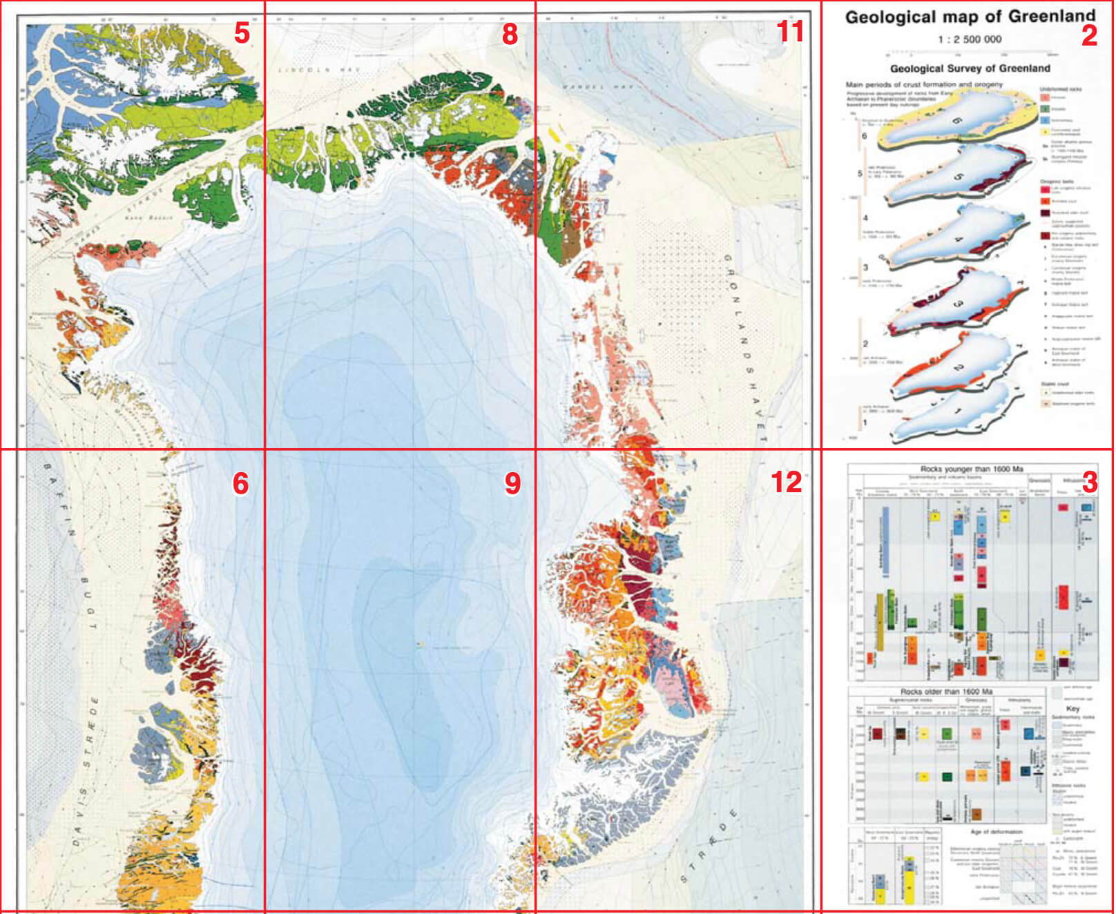
The geological development of Greenland spans a period of nearly 4 Ga, from Eoarchaean to the Quaternary. Greenland is the largest island on Earth with a total area of 2 166 000 km2, but only c. 410 000 km2 are exposed bedrock, the remaining part being covered by a major ice sheet (the Inland Ice) reaching over 3 km in thickness. The adjacent offshore areas underlain by continental crust have an area of c. 825 000 km2.
Greenland is dominated by crystalline rocks of the Precambrian shield, which formed during a succession of Archaean and Palaeoproterozoic orogenic events and stabilised as a part of the Laurentian shield about 1600 Ma ago. The shield area can be divided into three distinct types of basement provinces: (1) Archaean rocks (3200–2600 Ma old, with local older units up to> 3800 Ma) that were almost unaffected by Proterozoic or later orogenic activity; (2) Archaean terrains reworked during the Palaeoproterozoic around 1900–1750 Ma ago; and (3) terrains mainly composed of juvenile Palaeoproterozoic rocks (2000–1750 Ma in age). Subsequent geological developments mainly took place along the margins of the shield. During the Proterozoic and throughout the Phanerozoic major sedimentary basins formed, notably in North and North-East Greenland, in which sedimentary successions locally reaching 18 km in thickness were deposited. Palaeozoic orogenic activity affected parts of these successions in the Ellesmerian fold belt of North Greenland and the East Greenland Caledonides; the latter also incorporates reworked Precambrian crystalline basement complexes.
Late Palaeozoic and Mesozoic sedimentary basins developed along the continent–ocean margins in North, East and West Greenland and are now preserved both onshore and offshore. Their development was closely related to continental break-up with formation of rift basins. Initial rifting in East Greenland in latest Devonian to earliest Carboniferous time and succeeding phases culminated with the opening of the North Atlantic Ocean in the late Paleocene. Sea-floor spreading was accompanied by extrusion of Palaeogene (early Tertiary) plateau basalts in both central West and central–southern East Greenland.
During the Quaternary Greenland was almost completely covered by ice, and the present day Inland Ice is a relic from the Pleistocene ice ages. Vast amounts of glacially eroded detritus were deposited on the continental shelves around Greenland.
Mineral exploitation in Greenland has so far encompassed cryolite, lead-zinc, gold, olivine and coal. Current prospecting activities in Greenland are concentrated on gold, base metals, platinum group elements, molybdenum, iron ore, diamonds and lead-zinc. Hydrocarbon potential is confined to the major Phanerozoic sedimentary basins, notably the large basins offshore North-East and West Greenland. While reserves of oil or gas have yet to be found, geophysical data combined with discoveries of oil seeps onshore have revealed a considerable potential for offshore oil and gas.
How to Cite
Share
Copyright (c) 2009 Niels Henriksen, A.K. Higgins, Feiko Kalsbeek, T. Christopher R. Pulvertaft
This work is licensed under a Creative Commons Attribution 4.0 International License.
Supplementary Files
- Colophon, contents, preface, introduction
- Crystalline rocks older than 1600 Ma: the Greenland Precambrian shield
- Proterozoic to Phanerozoic geological development after formation of the Precambrian shield
- Glaciology, offshore geology
- Mineral deposits, acknowledgements
- References, legend explanation, place names register, index
Downloads
Niels Henriksen, A.K. Higgins, Feiko Kalsbeek and T. Christopher R. Pulvertaft
Greenland's geological development spans a period of c. 4 Ga from the Eoarchaean to the Quaternary. An overview of the geology was presented in 1995 on a geological map at a scale of 1:2 500 000, followed by a descriptive [...]