How to Cite


Share
Copyright (c) 2007 Zyad K Al-Hamdani, Johnny Reker, Jørgen O Leth, Anu Reijonen, Aarno T Kotilainen, Grete E Dinesen

This work is licensed under a Creative Commons Attribution 4.0 International License.
Abstract
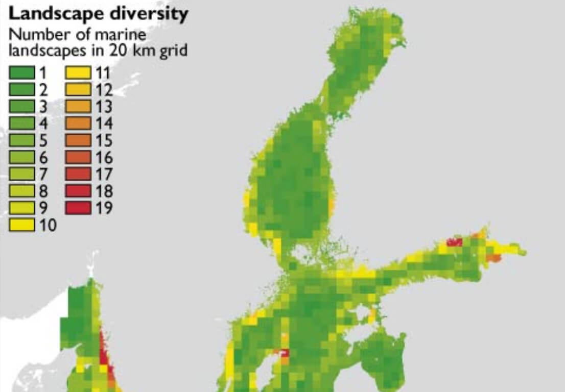
The Baltic Sea is one of the largest brackish water bodies in the world (Segerstråle 1957) with a number of basins varying from almost fresh water in the northern part of the Bothnian Bay via the more brackish conditions in the southern part to the saline waters of the Kattegat. The Baltic Sea is subject to severe environmental degradation caused by commercial and leisure activities, including fisheries, dredging, tourism, coastal development and land-based pollution sources. This causes severe pressures on vulnerable marine habitats and natural resources, and a tool for aiding marine management is therefore strongly needed. The marine landscape concept presented by Roff &Taylor (2000) is based on the use of available broad-scale geological, physical and hydrographical data to prepare ecologically meaningful maps for areas with little or no biological information. The concept, which was elaborated by Day & Roff (2000) was applied in UK waters (Connor et al. 2006) before it was adopted by the BALANCE project described here. The aim of developing marine landscape maps is to characterise the marine environment of the Baltic Sea region (the Baltic Sea together with the Kattegat) using geophysical and hydrographical parameters. Such maps can be applied, for example, to an assessment of the Baltic-wide network of marine protected areas, and thus provide a sustainable ecosystem-based approach to the protection of the marine environment from human activities, and contribute to the conservation of marine biodiversity. The BALANCE project is based on transnational and cross-sectoral co-operation with participants from nine countries surrounding the Baltic Sea as well as Norway (Fig. 1), and is partially financed by the European Union through the BSR INTERREG IIIB programme.
How to Cite
Share
Copyright (c) 2007 Zyad K Al-Hamdani, Johnny Reker, Jørgen O Leth, Anu Reijonen, Aarno T Kotilainen, Grete E Dinesen
This work is licensed under a Creative Commons Attribution 4.0 International License.
Downloads
Edited by Martin Sønderholm and A.K. Higgins
The Review of Survey activities presents a selection of 17 papers reflecting the wide spectrum of activities of the Geological Survey of Denmark and Greenland, from the microscopic to the plate-tectonic level.
Activities in Denmark: The Survey's field of activities in Denmark is illustrated by three papers on [...]