How to Cite


Share

This work is licensed under a Creative Commons Attribution 4.0 International License.
Abstract
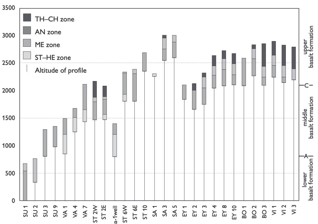
The first maps of the regional distribution of zeolites in the Palaeogene basalt plateau of the Faroe Islands are presented. The zeolite zones (thomsonite-chabazite, analcite, mesolite, stilbite-heulandite, laumontite) continue below sea level and reach a depth of 2200 m in the Lopra-1/1A well. Below this level, a high temperature zone occurs characterised by prehnite and pumpellyite. The stilbite-heulandite zone is the dominant mineral zone on the northern island, Vágar, the analcite and mesolite zones are the dominant ones on the southern islands of Sandoy and Suðuroy and the thomsonite-chabazite zone is dominant on the two northeastern islands of Viðoy and Borðoy. It is estimated that zeolitisation of the basalts took place at temperatures between about 40°C and 230°C. Palaeogeothermal gradients are estimated to have been 66 ± 9°C/km in the lower basalt formation of the Lopra area of Suðuroy, the southernmost island, 63 ± 8°C/km in the middle basalt formation on the northernmost island of Vágar and 56 ± 7°C/km in the upper basalt formation on the central island of Sandoy. A linear extrapolation of the gradient from the Lopra area places the palaeosurface of the basalt plateau near to the top of the lower basalt formation. On Vágar, the palaeosurface was somewhere between 1700 m and 2020 m above the lower formation while the palaeosurface on Sandoy was between 1550 m and 1924 m above the base of the upper formation. The overall distribution of zeolites reflects primarily variations in the maximum depth of burial of the basalt rather than differences in heat flow. The inferred thinning of the middle and upper basalt formation from the central to the southern part of the Faroes is in general agreement with a northerly source area for these basalts, centred around the rift between the Faroes and Greenland. The regional zeolite distribution pattern is affected by local perturbations of the mineral zone boundaries that reflect local differences in the temperature, perhaps related to the circulation of water in the underground. The zonal distribution pattern suggests that these temperature anomalies are in part related to NW–SE-trending eruption fissures or zones of weakness separating the present islands and are subparallel to transfer zones in the Faroe–Shetland Basin. Both the regional and the local distribution of zeolite assemblages are probably a reflection of the basic volcanic-tectonic pattern of the Faroe Islands.
How to Cite
Share
Downloads
Editors: James A. Chalmers and Regin Waagstein
The Faroe Islands in the northern North Altantic consist primarily of Palaeogene eruptive volcanic rocks. Two research boreholes were drilled in 1980 and 1981 on the islands, the deeper of which, Lopra-1, extended 2 km into the unexposed part of the volcanic succession.
Exploration for [...]