How to Cite


Share

This work is licensed under a Creative Commons Attribution 4.0 International License.
Abstract
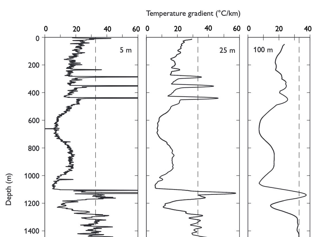
Information on temperature, temperature gradients, thermal conductivity and heat flow from the c. 3.5 km deep Lopra-1/1A borehole in the Faroe Islands is presented and analysed. The upper 2450 m of the drilled sequence consists of thick tholeiitic basalt flows and the deeper parts of hyaloclastites and thin beds of basalt. Temperature data originate from high precision temperature logging a long time after drilling to a depth of 2175 m (the original Lopra-1 borehole) and from commercial temperature logs measured a short time after drilling to a depth of 3430 m (Lopra-1/1A). The high-precision temperature log determines accurately levels of inflow of groundwater to the borehole and significant thermal disturbances to a depth of c. 1250 m. Below 1300 m, no significant disturbances are seen and interval temperature gradients for large depth intervals show only small variations between 28 and 33°C/km. The mean least-squares gradient for the depth interval of 1400–3430 m is 31.4°C/ km. In clear contrast to these overall very homogeneous, large-interval, mean temperature gradients, great local variability, between gradients of 20–25°C/km and 45°C/km, was observed between about 1300 and 2175 m (maximum depth of the high-resolution temperature log). These gradient variations are interpreted to be due to thermal conductivity variations and to reflect varying secondary mineralisation and mineral alterations. A preliminary analysis of the Lopra-1/1A temperature–depth function in terms of long-term palaeoclimatic signals indicates subsurface temperatures below about 1300 m to be in equilibrium with mean surface temperatures significantly below zero during the last glacial period. A subsequent temperature increase of 12–16°C occurred at around the termination of the last glaciation. The measured temperatures (some after correction) and the thermal regime below 1300 m seem to represent conductive equilibrium conditions without significant disturbances from the effect of drilling, groundwater flow or long-term palaeoclimatic surface temperature variations. Thermal conductivity measured on samples of basalt taken from drill cores and surface outcrops in the area of the borehole shows values within a rather narrow range and a well-defined mean value for low porosity basalts of about 1.8 W/m°C , while a few samples of lapilli-tuff/tuff from the borehole gave values around 1.9 W/m°C . Lapilli-tuff and tuff seem to have higher matrix (grain) conductivity than basalt. Heat flow is estimated at 60 ± 5 mW/m2. A heat flow of this magnitude is consistent with the Faroe Islands being underlain by continental crust.
How to Cite
Share
Downloads
Editors: James A. Chalmers and Regin Waagstein
The Faroe Islands in the northern North Altantic consist primarily of Palaeogene eruptive volcanic rocks. Two research boreholes were drilled in 1980 and 1981 on the islands, the deeper of which, Lopra-1, extended 2 km into the unexposed part of the volcanic succession.
Exploration for [...]