How to Cite


Share

This work is licensed under a Creative Commons Attribution 4.0 International License.
Abstract
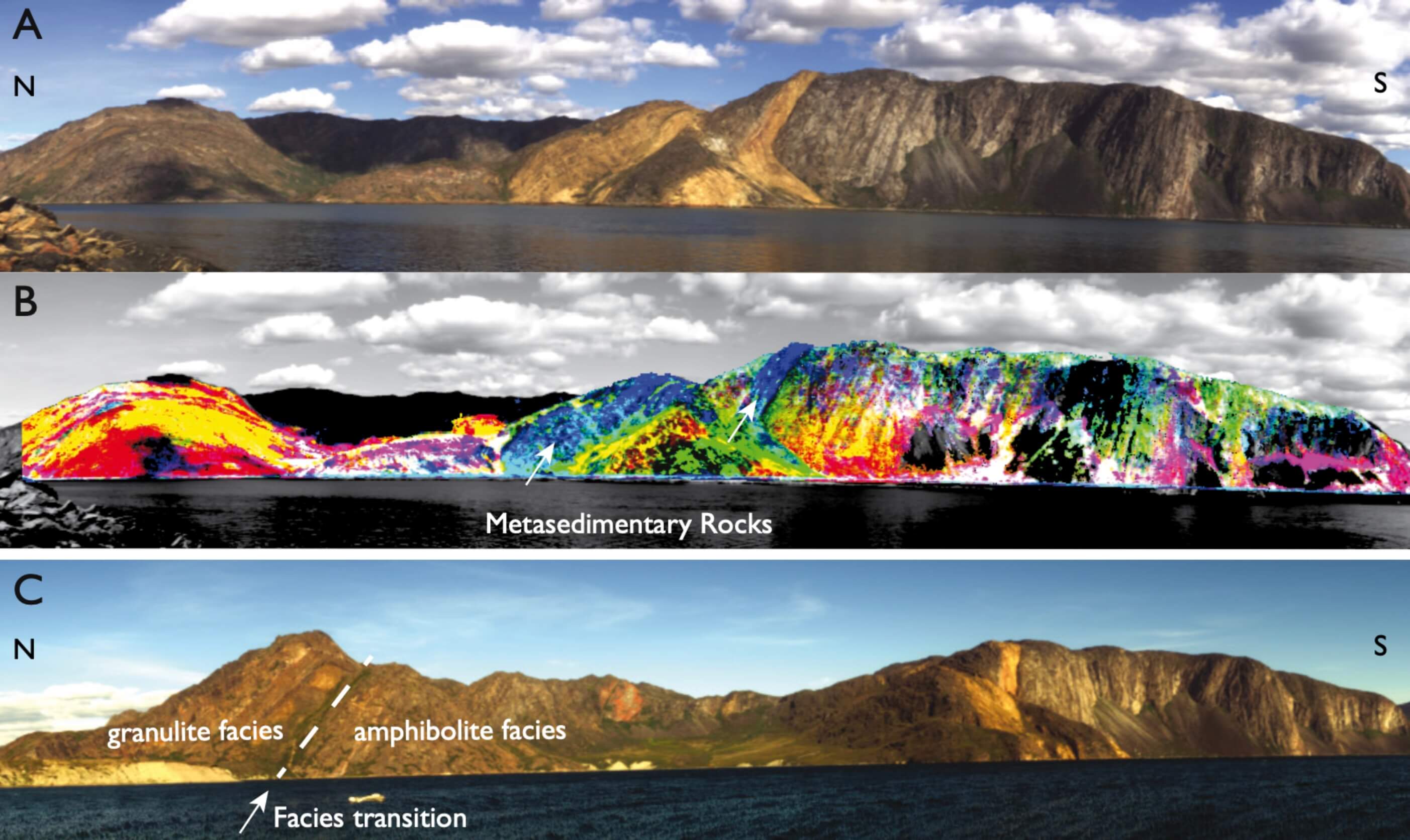
While multispectral images have been in regular use since the 1970s, the widespread use of hyperspectral images is a relatively recent trend. This technology comprises remote measurement of specific chemical and physical properties of surface materials through imaging spectroscopy. Regional geological mapping and mineral exploration are among the main applications that may benefit from hyperspectral technology. Minerals and rocks exhibit diagnostic spectral features throughout the electromagnetic spectrum that allow their chemical composition and relative abundance to be mapped. Most studies using hyperspectral data for geological applications have concerned areas with arid to semi-arid climates, and using airborne data collection. Other studies have investigated terrestrial outcrop sensing and integration with laser scanning 3D models in ranges of up to a few hundred metres, whereas less attention has been paid to ground-based imaging of more distant targets such as mountain ridges, cliffs or the walls of large pits. Here we investigate the potential of using such data in well-exposed Arctic regions with steep topography as part of regional geological mapping field campaigns, and to test how airborne hyperspectral data can be combined with similar data collected on the ground or from moving platforms such as a small ship. The region between the fjords Ikertoq and Kangerlussuaq (Søndre Strømfjord) in West Greenland was selected for a field study in the summer of 2016. This region is located in the southern part of the Palaeoproterozoic Nagssugtoqidian orogen and consists of high-grade metamorphic ortho- and paragneisses and metabasic rocks (see below). A regional airborne hyperspectral data set (i.e. HyMAP) was acquired here in 2002 (Tukiainen & Thorning 2005), comprising 54 flight lines covering an area of c. 7500 km2; 19 of these flight lines were selected for the present study (Fig. 1). The target areas visited in the field were selected on the basis of preliminary interpretations of HyMap scenes and geology (Korstgård 1979). Two different sensors were utilised to acquire the new hyperspectral data, predominantly a Specim AisaFenix hyperspectral scanner due to its wide spectral range covering the visible to near infrared and shortwave infrared parts of the electromagnetic spectrum. A Rikola Hyperspectral Imager constituted a secondary imaging system. It is much smaller and lighter than the Fenix scanner, but is spectrally limited to the visible near infrared range. The results obtained from combining the airborne hyperspectral data and the Rikola instrument are presented in Salehi (2018), this volume. In addition, representative samples of the main rock types were collected for subsequent laboratory analysis. A parallel study was integrated with geological and 3D photogrammetric mapping in Karrat region farther north in West Greenland (Rosa et al. 2017; Fig. 1).
How to Cite
Share
Downloads
Editors Adam A. Garde, Ole Bennike and W. Stuart Watt
The 22 contributions in this issue of Review of Survey activities demonstrate the broad field of activities performed by the Geological Survey of Denmark and Greenland and external partners.
Seven papers on Danish geology comprise an investigation of reservoir sandstones for oil [...]