
How to Cite


Share
Copyright (c) 2026 Jun Liu, Julian Koch, Simon Stisen, Lars Troldborg, Raphael Schneider

This work is licensed under a Creative Commons Attribution 4.0 International License.
Abstract
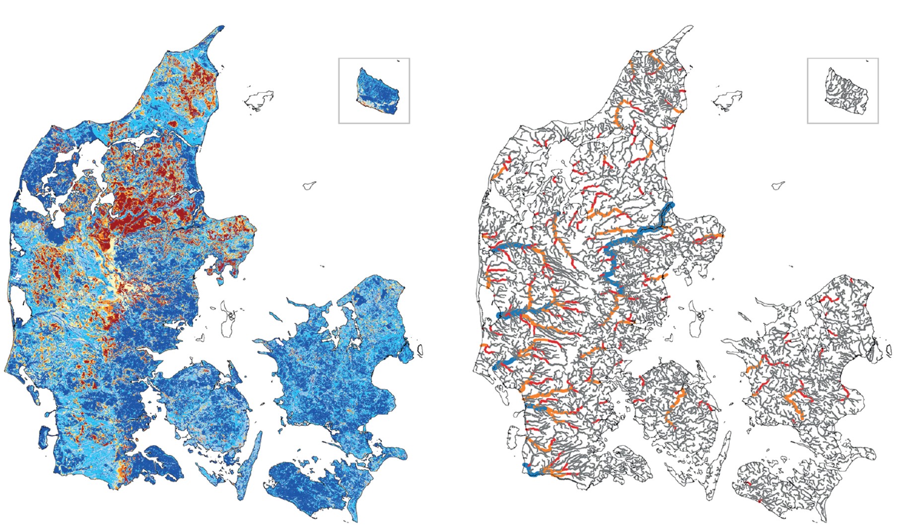
Most operational flood forecasting systems provide predictions of pluvial and fluvial floods, often neglecting groundwater flooding. Groundwater-induced floods can occur when prolonged rainfall, high river stages or elevated sea levels raise the groundwater table above the surface of the land, often occurring in low-lying areas or areas with specific soil and land-surface conditions. This study presents an operational, national-scale, integrated flood forecasting system that combines surface water and groundwater components – such as river discharge and high groundwater levels – to assess flood risk in Denmark. The system has been proven to effectively capture peak river flows and elevated groundwater levels, as it did across the country during the winter of 2024, and provide local-scale insights, as exemplified during a specific flood event in Varde, west Denmark. This study demonstrates how groundwater flooding, often neglected in operational forecasting, can be effectively incorporated at a national scale to support more informed flood management.
How to Cite
Share
Copyright (c) 2026 Jun Liu, Julian Koch, Simon Stisen, Lars Troldborg, Raphael Schneider
This work is licensed under a Creative Commons Attribution 4.0 International License.
Funding
This research was supported by public funding in Denmark.Downloads
An annual collection of articles submitted to GEUS Bulletin and published throughout 2026. Published online only. This issue is open for submissions until the end of 2026.
Cover image coming soon.

References
- Abbott, M.B., Bathurst, J.C., Cunge, J.A., O’Connell, P.E. & Rasmussen, J. 1986: An introduction to the European Hydrological System – Systeme Hydrologique Europeen, ‘SHE’, 1: History and philosophy of a physically-based, distributed modelling system. Journal of Hydrology 87, 45–59. https://doi.org/10.1016/0022-1694(86)90114-9
- Adams,T.E., Gangodagamage, C. & Pagano, T.C. 2024: Flood forecasting: A global perspective. Elsevier. https://doi.org/10.1016/C2014-0-01361-5
- Allerup, P., Madsen, H. & Vejen, F. 1997: A comprehensive model for correcting point precipitation. Hydrology Research 28, 1–20. https://doi.org/10.2166/nh.1997.0001
- Allocca, V., Di Napoli, M., Coda, S., Carotenuto, F., Calcaterra, D., Di Martire, D. & De Vita, P. 2021: A novel methodology for Groundwater Flooding Susceptibility assessment through Machine Learning techniques in a mixed-land use aquifer. Science of The Total Environment 790, 148067. https://doi.org/10.1016/j.scitotenv.2021.148067
- Becker, B., Reichel, F., Bachmann, D. & Schinke, R. 2022: High groundwater levels: Processes, consequences, and management. Wiley Interdisciplinary Reviews Water 9, 1–21. https://doi.org/10.1002/wat2.1605
- Behzad, H.M. & Nie, Y. 2024: Groundwater flooding risks overlooked. Science 384, 518–519. https://doi.org/10.1126/science.ado6820
- Cobby, D., Morris, S., Parkes, A. & Robinson, V. 2009: Groundwater flood risk management: Advances towards meeting the requirements of the EU floods directive. Journal of Flood Risk Management 2, 111–119. https://doi.org/10.1111/j.1753-318X.2009.01025.x
- Cole, S.J., Moore, R.J., Wells, S.C. & Mattingley, P.S. 2016: Real-time forecasts of flood hazard and impact: some UK experiences. FLOODrisk 2016, 3rd European Conference on Flood Risk Management, E3S Web of Conferences 7, 18015.
- DHI. 2025: MIKE SHE User Guide and Reference Manual. https://manuals.mikepoweredbydhi.help/latest/Water_Resources/MIKE_SHE_Print.pdf (accessed November 2025).
- DMI. 2025: Weather Model (HARMONIE) for DINI and IG: https://opendatadocs.dmi.govcloud.dk/Data/Forecast_Data_%0AWeather_Model_HARMONIE_DINI_IG (accessed October 2025).
- DTU, Department of Management Engineering, Kgs. Lyngby Denmark https://backend.orbit.dtu.dk/ws/portalfiles/portal/268507361/Samfunds_konomiske_konsekvenser_af_oversv_mmelser_og_investeringer_i_klimatilpasning_final_reduced.pdf (accessed November 2022).
- Frie Data. 2025: https://www.dmi.dk/frie-data. (accessed June 2025).
- Halsnæs, K., Larsen, M.A.D. & Drenck, K.L. 2022: Samfundsøkonomiske konsekvenser af oversvømmelser og investeringer i klimatilpasning. DTU for Miljøministeriet.
- Hansen, M., Vejby, J. & Koch, J. 2025: Flood mapping using Sentinel-1 imagery with topographical and hydrological contextualization: Case study from Ribe, Denmark. International Journal of Applied Earth Observation and Geoinformation 143, 104816. https://doi.org/10.1016/j.jag.2025.104816
- Henriksen,H.J. et al. 2020: Dokumentationsrapport vedr. modelleverancer til Hydrologisk Informations-og Prognosesystem. The Geological Survey of Denmark and Greenland (GEUS). Copenhagen, Denmark.
- Henriksen, H.J. et al. 2021: Udvikling af landsdækkende modelberegninger af terrænnære hydrologiske forhold i 100m grid ved anvendelse af DK-modellen: Dokumentationsrapport vedr. modelleverancer til Hydrologisk Informations- og Prognosesystem. Udarbejdet som en del af Den Fællesoffentlige Digitaliseringsstrategi 2016–2020. Initiativet Fælles Data om Terræn, Klima og Vand. The Geological Survey of Denmark and Greenland (GEUS). https://doi.org/10.22008/gpub/38113
- Henriksen, H.J., Ondracek, M. & Troldborg, L. 2023: Vandressourceopgørelse – Datarapport. Baggrundsrapport til Miljøstyrelsens samlede afrapportering omkring forvaltning af fremtidens drikkevandsressource. Metode, resultater, usikkerheder og forventede klimapåvirkninger. The Geological Survey of Denmark and Greenland (GEUS). https://doi.org/10.22008/gpub/34675
- Højberg, A.L., Troldborg, L., Stisen, S., Christensen, B.B.S. & Henriksen, H.J. 2013: Stakeholder driven update and improvement of a national water resources model. Environmental Modelling & Software 40, 202–213. https://doi.org/10.1016/j.envsoft.2012.09.010
- Jüpner, R. & Schüller, A. 2025: Operativer Hochwasserschutz. Springer Vieweg Wiesbaden. XXVIII, 239. https://doi.org/10.1007/978-3-658-46760-9
- Koch, J., Gotfredsen, J., Schneider, R., Troldborg, L., Stisen, S. & Henriksen, H.J. 2021: High resolution water table modeling of the shallow groundwater using a knowledge-guided gradient boosting decision tree model. Frontiers in Water 3, 1–14. https://doi.org/10.3389/frwa.2021.701726
- Kreibich, H., Thieken, A.H., Grunenberg, H., Ullrich, K. & Sommer, T. 2009: Extent, perception and mitigation of damage due to high groundwater levels in the city of Dresden, Germany. Natural Hazards and Earth System Sciences 9, 1247–1258. https://doi.org/10.5194/nhess-9-1247-2009
- Liu, J., Koch, J., Stisen, S., Troldborg, L. & Schneider, R.J.M. 2024: A national-scale hybrid model for enhanced streamflow estimation – Consolidating a physically based hydrological model with long short-term memory (LSTM) networks. Hydrology and Earth Systems Sciences 28, 2871–2893. https://doi.org/10.5194/hess-28-2871-2024
- Liu, J., Koch, J., Stisen, S., Troldborg, L., Højberg, A.L., Thodsen, H., Hansen, M.F.T. & Schneider, R.J.M. 2025: CAMELS-DK: Hydrometeorological time series and landscape attributes for 3330 Danish catchments with streamflow observations from 304 gauged stations. Earth System Science Data 17, 1551–1572. https://doi.org/10.5194/essd-17-1551-2025
- Merz, B. et al. 2021: Causes, impacts and patterns of disastrous river floods. Nature Reviews Earth & Environment 2, 592–609. https://doi.org/10.1038/s43017-021-00195-3
- Moore, R.J. & Bell, V.A. 2002: Incorporation of groundwater losses and well level data in rainfall-runoff models illustrated using the PDM. Hydrology and Earth System Sciences 6, 25–38. https://doi.org/10.5194/hess-6-25-2002
- Moore, R.J., Cole, S.J. & Bell, V.A. 2006: Issues in flood forecasting: Ungauged basins, extreme floods and uncertainty In: Tchiguirinskaia, I. et al. (eds): Frontiers in Flood Research, 8th Kovacs Colloquium, UNESCO, Paris, June/July 2006. IAHS Publications 305, 103–122.
- Nearing, G. et al. 2024: Global prediction of extreme floods in ungauged watersheds. Nature 627, 559–563. https://doi.org/10.1038/s41586-024-07145-1
- NOAA. 2016:National water model: Improving NOAA’s water prediction services. https://water.noaa.gov/assets/styles/public/images/wrn-national-water-model.pdf (accessed July 2025)
- Pagano, T.C., Elliott, J.F., Anderson, B.G., & Perkins, J.K. 2016: Chapter 1 - Australian Bureau of Meteorology Flood Forecasting and Warning. In: Adams, T.E. & Pagano, T.C (eds): Flood Forecasting, 3–40, Academic Press, ISBN 9780128018842, https://doi.org/10.1016/B978-0-12-801884-2.00001-3
- Palmer, T.N., Brankovic, C., Molteni, F., Tibaldi, S., Ferranti, L., Hollingsworth, A., Cubasch, U. & Klinker, E. 1990: The European Centre for Medium-Range Weather Forecasts (ECMWF) program on extended-range prediction. Bulletin of the American Meteorological Society 71, 1317–1330. https://doi.org/10.1175/1520-0477(1990)071<1317:TECFMR>2.0.CO;2
- Parkin, G. 2024: Groundwater flooding – A hidden hazard. In: Proceedings of the Institution of Civil Engineers – Civil Engineering 177, 50–52. Emerald Publishing. https://doi.org/10.1680/jcien.24.00905
- Plauborg, F.L., Refsgaard, J.C., Henriksen, H.J., Blicher-Mathiesen, G. & Kern-Hansen, C. 2002: Vandbalance på mark-og oplandsskala. Danmarks Jordbrugsforskning. DJF Rapport – Markbrug Bind 70, 45 pp.
- Price, D., Hudson, K., Boyce, G., Schellekens, J., Moore, R.J., Clark, P., Harrison, T., Connolly, E. & Pilling, C. 2012: Operational use of a grid-based model for flood forecasting. In: Proceedings of the Institution of Civil Engineers – Water Management 165, 65–77. https://doi.org/10.1680/wama.2012.165.2.65
- Scharling,M. 1999a: Klimagrid Danmark – Nedbør, lufttemperatur og potentiel fordampning 20×20 & 40×40 km. Metodebeskrivelse. Technical Report 99-12. Danish Meteorological Institute, Copenhagen, Denmark.
- Scharling, M. 1999b: Klimagrid Danmark – Nedbør 10×10 km (ver. 2). Metodebeskrivelse. Technical Report 99-15, 15–17. Danish Meteorological Institute, Copenhagen, Denmark.
- Schneider, R., Koch, J., Troldborg, L., Henriksen, H.J. & Stisen, S. 2022: Machine-learning-based downscaling of modelled climate change impacts on groundwater table depth. Hydrology and Earth System Sciences 26, 5859–5877. https://doi.org/10.5194/hess-26-5859-2022
- Schneider, R., Karlsson Seidenfaden, I., Hansen, M.F.T., Koch, J., Andreasen, M., Nilsson, B. & Stisen, S. 2025: Validating drought propagation through the entire hydrological cycle simulated with an integrated national-scale hydrological model. EGU General Assembly 2025, Vienna, Austria, 27 Apr–2 May 2025. EGU25-10370. https://doi.org/10.5194/egusphere-egu25-10370
- Seidenfaden, I.K., Skjerbæk, M.R., Henriksen, H.J., Kjeldsen, K.K. & Sonnenborg, T.O. 2025: Compound flooding from storm surges, precipitation, rivers, and groundwater – Hydrodynamic modeling in a coastal catchment. Water Resources Research 61, e2024WR037563. https://doi.org/10.1029/2024WR037563
- Smith, P.J., Pappenberger, F., Wetterhall, F., Del Pozo, J.T., Krzeminski, B., Salamon, P., Muraro, D., Kalas, M. & Baugh, C. 2016: Chapter 11 - On the operational implementation of the European Flood Awareness System (EFAS). In: Adams, T.E. & Pagano, T.C. (eds): Flood forecasting, 313–348. Elsevier. https://doi.org/10.1016/B978-0-12-801884-2.00011-6
- Stisen, S., Sonnenborg, T.O., Højberg, A.L., Troldborg, L. & Refsgaard, J.C. 2011: Evaluation of climate input biases and water balance issues using a coupled surface–subsurface model. Vadose Zone Journal 10, 37–53, https://doi.org/10.2136/vzj2010.0001
- Stisen, S., Højberg, A.L., Troldborg, L., Refsgaard, J.C., Christensen, B.S.B., Olsen, M. & Henriksen, H.J. 2012: On the importance of appropriate precipitation gauge catch correction for hydrological modelling at mid to high latitudes. Hydrology and Earth System Sciences 16, 4157–4176. https://doi.org/10.5194/hess-16-4157-2012
- Tellman, B., Sullivan, J.A., Kuhn, C., Kettner, A.J., Doyle, C.S., Brakenridge, G.R., Erickson, T.A. & Slayback, D.A. 2021: Satellite imaging reveals increased proportion of population exposed to floods. Nature 596, 80–86. https://doi.org/10.1038/s41586-021-03695-w

