
How to Cite


Share
Copyright (c) 2024 Rasmus Bødker Madsen, Frederik Alexander Falk, Ingelise Møller, Anne-Sophie Høyer

This work is licensed under a Creative Commons Attribution 4.0 International License.
Abstract
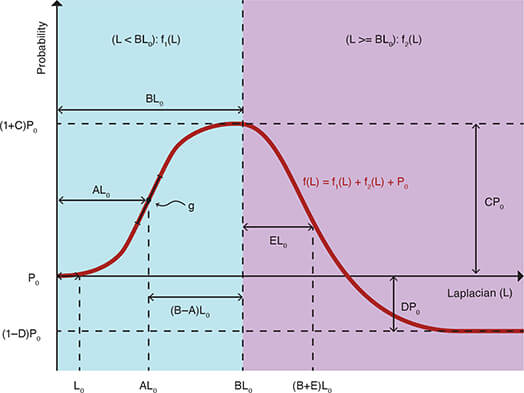
This study presents a probabilistic method for extracting informed points from geological surfaces, named INPOX. The method generates a probability map from the existing surface by calculating the Laplacian at each location and combining it with a user-defined transfer function. A set of points from the surface is then extracted with a density proportional to the probability map. The method allows a de-coupling of the most informative points in the surface from points carrying less or even biased information. INPOX can be applied on any geological surface where the user needs to retrieve the structurally relevant parts and remove the information created by the initial interpolation. Here, we test INPOX on synthetic data, with and without supressing interpolation artifacts. In both cases, the informed points extracted with INPOX outperforms a uniform probability map in recreating the original features. We show that the method requires a minimum of points to be extracted for INPOX to be more informative than a uniform point retrieval. Finally, to showcase the strength of the method in both retrieving the relevant geological features and suppressing the existing interpolation artifacts, we apply INPOX to a real case surface from the Danish national hydrostratigraphic model.
How to Cite
Share
Copyright (c) 2024 Rasmus Bødker Madsen, Frederik Alexander Falk, Ingelise Møller, Anne-Sophie Høyer
This work is licensed under a Creative Commons Attribution 4.0 International License.
Funding
The method was developed during consultancy work for the Danish EPA, while the hours for turning the results into a scientific contribution and writing the manuscript was provided by Geocenter Denmark through the project DECODE3D.Downloads
An annual collection of articles submitted to GEUS Bulletin and published throughout 2024. Published online only. This issue is open until the end of 2024.
Cover photo: a piece of fossilised wood from the Miocene brown coal deposit in Denmark (Credit: Kasia Śliwińska). Read more in Śliwińska, K. K., Denk, T., [...]
References
- Agrawal, A., Raskar, R. & Chellappa, R. 2006: What is the range of surface reconstructions from a gradient field? In: Leonardis, A., Bischof, H. & Pinz, A. (eds): Computer Vision – ECCV 2006. ECCV 2006. Lecture Notes in Computer Science 3951, 578–591. Springer. https://doi.org/10.1007/11744023_45
- Boissonnat, J.D. & Oudot, S. 2006: Provably good sampling and meshing of Lipschitz surfaces. In: SCG ’06: Proceedings of the Twenty-second Annual Symposium on Computational Geometry, 337–346. https://doi.org/10.1145/1137856.1137906
- Brus, D.J., de Gruijter, J.J. & van Groenigen, J.W. 2006: Chapter 14 designing spatial coverage samples using the k-means clustering algorithm. Developments in Soil Science 31, 183–192. https://doi.org/10.1016/S0166-2481(06)31014-8
- Enemark, T. et al. 2023: Incorporating interpretation uncertainties from deterministic 3D hydrostratigraphic models in groundwater models. Hydrology and Earth System Sciences [preprint/in press]. https://doi.org/10.5194/hess-2023-74
- Groshong, R.H. 2006: 3-D structural geology: a practical guide to quantitative surface and subsurface map interpretation. 2nd ed. 400 pp. Springer.
- Hansen, T.M. 2021: Entropy and information content of geostatistical models. Mathematical Geosciences 53, 163–184. https://doi.org/10.1007/s11004-020-09876-z
- Harker, M. & O’Leary, P. 2015: Regularized reconstruction of a surface from its measured gradient field: algorithms for spectral, Tikhonov, constrained, and weighted regularization. Journal of Mathematical Imaging and Vision 51, 46–70. https://doi.org/10.1007/s10851-014-0505-4
- Kaufmann, O. & Martin, T. 2008: 3D geological modelling from boreholes, cross-sections and geological maps , application over former natural gas storages in coal mines. Computers & Geosciences 34, 278–290. https://doi.org/10.1016/j.cageo.2007.09.005
- Kawo, N.S., Korus, J. & Gulbrandsen, M.L. 2023: Multiple-point statistical modeling of three-dimensional glacial aquifer heterogeneity for improved groundwater management. Hydrogeology Journal 31, 1525–1546. https://doi.org/10.1007/s10040-023-02658-x
- Lelliott, M.R., Bridge, D.M., Kessler, H., Price, S.J. & Seymour, K.J. 2006: The application of 3D geological modelling to aquifer recharge assessments in an urban environment. Quarterly Journal of Engineering Geology and Hydrogeology 39, 293–302. https://doi.org/10.1144/1470-9236/05-027
- Madsen, R.B., Høyer, A.-S., Andersen, L.T., Møller, I. & Hansen, T.M. 2022: Geology-driven modeling: a new probabilistic approach for incorporating uncertain geological interpretations in 3D geological modeling. Engineering Geology 309, 106833. https://doi.org/10.1016/j.enggeo.2022.106833
- Madsen, R.B., Kim, H., Kallesøe, A.J., Sandersen, P.B.E., Vilhelmsen, T.N., Hansen, T.M., Christiansen, A.V., Møller, I. & Hansen, B. 2021a: 3D multiple-point geostatistical simulation of joint subsurface redox and geological architectures. Hydrology and Earth System Sciences 25, 2759–2787. https://doi.org/10.5194/hess-25-2759-2021
- Madsen, R.B., Møller, I. & Hansen, T.M. 2021b: Choosing between Gaussian and MPS simulation: the role of data information content – a case study using uncertain interpretation data points. Stochastic Environmental Research and Risk Assessment 35, 1563–1583. https://doi.org/10.1007/s00477-020-01954-2
- Mosegaard, K. 2012: Limits to nonlinear inversion. In: Jónasson, K. (ed.): Applied parallel and scientific computing, 11–21. Springer. https://doi.org/10.1007/978-3-642-28151-8_2
- Miljøstyrelsen 2023: FOHM – Fælles offentlig hydrologisk model (Danish national hydrostratigraphic model). https://data.geus.dk/geusmap/?mapname=fohm&lang=en#baslay=baseMapDa&optlay=&extent= 168222.2222222222,6019065.972222222,873777.7777777778,6430934.027777778
- Robins, N.S., Davies, J. & Dumpleton, S. 2008: Groundwater flow in the South Wales coalfield: historical data informing 3D modelling. Quarterly Journal of Engineering Geology and Hydrogeology 41, 477–486. https://doi.org/10.1144/1470-9236/07-055
- Royse, K.R. 2010: Combining numerical and cognitive 3D modelling approaches in order to determine the structure of the Chalk in the London Basin. Computers & Geosciences 36, 500–511. https://doi.org/10.1016/j.cageo.2009.10.001
- Seifert, D., Sonnenborg, T.O., Refsgaard, J.C., Højberg, A.L. & Troldborg, L. 2012: Assessment of hydrological model predictive ability given multiple conceptual geological models. Water Resources Research 48, 1–16. https://doi.org/10.1029/2011WR011149
- Setianto, A. & Triandini, T. 2015: Comparison of Kriging and inverse distance weighted (Idw) interpolation methods in lineament extraction and analysis. Journal of Applied Geology 5, 21–29. https://doi.org/10.22146/jag.7204
- Shalev-Shwartz, S. & Ben-David, S. 2014: Understanding machine learning: from theory to algorithms. Cambridge University Press. 397 pp. https://doi.org/10.1017/CBO9781107298019
- Van Der Meulen, M.J. et al. 2013: 3D geology in a 2D country: Perspectives for geological surveying in the Netherlands. Geologie en Mijnbouw/Netherlands Journal of Geosciences 92, 217–241. https://doi.org/10.1017/S0016774600000184
- Walvoort, D.J.J., Brus, D.J. & De Gruijter, J.J. 2010: An R package for spatial coverage sampling and random sampling from compact geographical strata by k-means. Computers & Geosciences 36, 1261–1267. https://doi.org/10.1016/j.cageo.2010.04.005
- Wellmann, J.F. & Caumon, G. 2018: 3-D Structural geological models: concepts, methods, and uncertainties. Advances in Geophysics 59, 121 pp. Elsevier Inc. https://doi.org/10.1016/bs.agph.2018.09.001
- Wycisk, P., Hubert, T., Gossel, W. & Neumann, C. 2009: High-resolution 3D spatial modelling of complex geological structures for an environmental risk assessment of abundant mining and industrial megasites. Computers & Geosciences 35, 165–182. https://doi.org/10.1016/j.cageo.2007.09.001
- Yilmaz, H.M. 2007: The effect of interpolation methods in surface definition: an experimental study. Earth Surface Processes and Landforms 32, 1346–1361. https://doi.org/10.1002/esp.1473

