
How to Cite


Share
Copyright (c) 2024 Samuel Paul Jackson, Kristian Svennevig, Kristian Kjellerup Kjeldsen

This work is licensed under a Creative Commons Attribution 4.0 International License.
Abstract
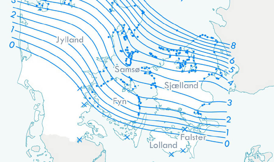
Data from an important historic article on late- and postglacial land-level changes in Denmark and the accompanying map are presented here in a new digital format. The original data were compiled in 1924 by Ellen Louise Mertz and comprise field observations of the marine limit in Denmark made over the late 19th and early 20th centuries. The original tables have been transcribed and expanded into a digital database consisting of 658 entries. The original map sheet has been georeferenced and 392 mapped points have been assigned coordinates. The points are linked to their attributes in the digital data table, making them newly amenable to geospatial analysis in a Geographic Information System. To demonstrate, we briefly present one such application, namely a reproduction and verification of the isolines of raised beach elevation from the original 1924 map.
How to Cite
Share
Copyright (c) 2024 Samuel Paul Jackson, Kristian Svennevig, Kristian Kjellerup Kjeldsen
This work is licensed under a Creative Commons Attribution 4.0 International License.
Supplementary Files
Funding
This work is supported by the Geocenter Denmark project ‘Sea-level rise and coastal flooding in Denmark: past, future, and policy’, with Geocenter partners at the Geological Survey of Denmark and Greenland, the Department of Geoscience at Aarhus University and the Department of Geosciences and Natural Resource Management at the University of Copenhagen.Downloads
An annual collection of articles submitted to GEUS Bulletin and published throughout 2024. Published online only. This issue is open until the end of 2024.
Cover photo: a piece of fossilised wood from the Miocene brown coal deposit in Denmark (Credit: Kasia Śliwińska). Read more in Śliwińska, K. K., Denk, T., [...]
References
- Christensen, C. & Nielsen, A.B. 2008: Dating Littorina sea shore levels in Denmark on the basis of data from a Mesolithic coastal settlement on Skagens Odde, Northern Jutland. Polish Geological Institute Special Papers 23, 27–38.
- Gregersen, S. & Voss, P. 2010: Irregularities in Scandinavian postglacial uplift/subsidence in time scales tens, hundreds, thousands of years. Journal of Geodynamics 50(1), 27–31. https://doi.org/10.1016/j.jog.2009.11.004
- Hansen, J.M., Aagaard, T. & Binderup, M. 2012: Absolute sea levels and isostatic changes of the eastern North Sea to central Baltic region during the last 900 years. Boreas 41(2), 180–208. https://doi.org/10.1111/j.1502-3885.2011.00229.x
- Jackson, S.P., Svennevig, K. & Kjeldsen, K.K. 2024: Ellen Louise Mertz’s 1924 ‘Overview of late- and postglacial elevation changes in Denmark’ (V.1). GEUS Dataverse. https://doi.org/10.22008/FK2/PI4GXI
- Mertz, E.L. 1924: Oversigt over de sen- og postglaciale niveauforandringer i Danmark. Danmarks Geologiske Undersøgelse, II. Række 41, 49 pp. https://doi.org/10.34194/raekke2.v41.6827
- QGIS Development Team 2021: QGIS Geographic Information System, (Version release date: October 2021) Open Source Geospatial Foundation Project. https://www.osgeo.org/projects/qgis/
- Sander, L., Hede, M.U., Fruergaard, M., Nielsen, L., Clemmensen, L.B., Kroon, A., Johannessen, P.N., Nielsen, L.H. & Pejrup, M. 2016: Coastal lagoons and beach ridges as complementary sedimentary archives for the reconstruction of Holocene relative sea-level changes. Terra Nova 28(1), 43–49. https://doi.org/10.1111/ter.12187
- SDFI (Danish Agency for Data Supply and Infrastructure) 2022a: Danmarks Topografiske Kortværk 1:25 000. https://dataforsyningen.dk/data/956 (accessed December 2022).
- SDFI (Danish Agency for Data Supply and Infrastructure) 2022b: Ortofoto forår - GeoDanmark. https://dataforsyningen.dk/data/981 (accessed December 2022).
- SDFI (Danish Agency for Data Supply and Infrastructure) 2022c: Lave Målebordsblade. https://dataforsyningen.dk/data/4519 (accessed December 2022).

