
How to Cite


Share
Copyright (c) 2023 Lærke Therese Andersen, Anne-Sophie Høyer, Mette Hilleke Mortensen, Lars Troldborg, Klaus Hinsby

This work is licensed under a Creative Commons Attribution 4.0 International License.
Abstract
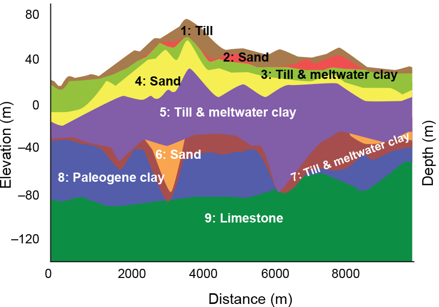
In this study, we upscale and simplify hydrostratigraphic information from a detailed model for Denmark to a pan-European scale. This is part of a larger project to develop a harmonised overview of the volume and depth of groundwater resources in a quasi-3D European groundwater resource model. A 10 km grid and a maximum of c. 10 hydrostratigraphic layers were chosen as the common scale for the European database. The Danish information is based on the national water resources model (the DK-model), where the information is significantly more detailed (100 m grid and up to 26 layers). Information was transferred from the DK-model to the quasi-3D model by a method involving computations of mean volumes and expert assessment to reduce layers in each cell. In this process, detailed hydrostratigraphic information is lost, which could otherwise be used for local groundwater flow modelling in Denmark. However, the strength of the quasi-3D model is that it still contains the volumes of all hydrostratigraphic units, both the saturated and unsaturated parts. Hence, the upscaled model can contribute to a relatively precise calculation of European groundwater resources for the quantitative assessment of groundwater status across Europe at a 10 × 10 km scale.
How to Cite
Share
Copyright (c) 2023 Lærke Therese Andersen, Anne-Sophie Høyer, Mette Hilleke Mortensen, Lars Troldborg, Klaus Hinsby
This work is licensed under a Creative Commons Attribution 4.0 International License.
Downloads
An annual collection of articles submitted to GEUS Bulletin and published throughout 2023. Published online only. This issue is open until the end of 2023.
Cover photo: satellite image is from the European Space Agency’s Copernicus Sentinel data 2023, as featured in Karlsson et al. 2023: A data set of monthly [...]
References
- Andersen, L.T., Mortensen, M.H., Troldborg, L. & Hinsby, K. 2021: GeoERA RESOURCE GROUNDWATER Deliverable 6.6. Justification of the Choices to Compile the Pan-EU Groundwater Resources Maps by All Participating Countries – Metadata Denmark. 52–62. https://repository.europe-geology.eu/egdidocs/resource/geoera%2Bresource%2Bdeliverable%2B66%2Bjustification%2Bof%2Bc.pdf (accessed September 2023)
- EGDI (European Geological Data Infrastructure) 2022: Pan-European Groundwater Resource Map: Volumes and Depths of Prime European Aquifers. https://data.geus.dk/egdi/?mapname=egdi_new_structure#baslay=baseMapGEUS&extent=-710780,1211800,6797980,5204710&layers=resource_netcdf11 (accessed November 2022)
- Hollis, J. et al. 2022: Pan-European geological data, information, and knowledge for a resilient, sustainable, and collaborative future. European Geologist 53, 5–19. https://doi.org/10.5281/zenodo.6883282
- Høyer, A.S., Jørgensen, F., Piotrowski, J.A. & Jakobsen, P.R. 2013: Deeply rooted glaciotectonism in western Denmark: Geological composition, structural characteristics and the origin of Varde hill-island. Journal of Quaternary Science 28(7), 683–696. https://doi.org/10.1002/jqs.2667
- Kivits, T., Janza, M. & Broers, H.P. 2020: GeoERA RESOURCE GROUNDWATER Deliverable 6.2. Database with information on volumes and depths at 10x10 and/or 25x25 km grids, 28 pp. https://repository.europe-geology.eu/egdidocs/resource/geoera%2Bresource%2Bdeliverable%2B62%2Bdatabase%2Bwith%2Binfo.pdf (accessed September 2023)
- Kivits, T., Rasmussen, V. & Broers, H.P. 2021: GeoERA RESOURCE GROUNDWATER Deliverable 6.4. Dataset to be included in the Information platform, 10 pp. https://repository.europe-geology.eu/egdidocs/resource/geoera%2Bresource%2Bdeliverable%2B64%2Bdataset%2Bto%2Bbe%2Bincl.pdf (accessed September 2023)
- Pedersen, S.A.S., Gravesen, P. & Hinsby, K. 2018: Chalk-glacitectonite, an important lithology in former glaciated terrains covering chalk and limestone bedrock. Geological Survey of Denmark and Greenland Bulletin 41, 21–24. https://doi.org/10.34194/geusb.v41.4333
- Sandersen, P.B.E. & Jørgensen, F. 2017: Buried tunnel valleys in Denmark and their impact on the geological architecture of the subsurface. GEUS Bulletin 38, 13–16. https://doi.org/10.34194/geusb.v38.4388
- Schoonderwoerd, E., Essink, O.G., Bos-Burgering, L., Kivits, T., Zaadnoordijk, W.J. & Broers, H.P. 2021: GeoERA RESOURCE GROUNDWATER – Deliverable 6.5. Water balance terms for the EU fresh groundwater grid. 32 pp. https://repository.europe-geology.eu/egdidocs/resource/geoera%2Bresource%2Bdeliverable%2B65%2Bwater%2Bbalance%2Bterm.pdf (accessed September 2023)
- Stisen, S., Ondracek, M., Troldborg, L., Schneider, R.J.M. & John van Til, M. 2019: National Vandressource Model – Modelopstilling og kalibrering af DK-model 2019. Danmarks og Grønlands Geologiske undersøgelse Rapport 2019/31, 1–125. https://doi.org/10.22008/gpub/32631
- Zhang, X. et al. 2021: Application of upscaling methods for fluid flow and mass transport in multi-scale heterogeneous media: A critical review. Applied Energy 303, 117603. https://doi.org/https://doi.org/10.1016/j.apenergy.2021.117603

