
How to Cite


Share
Copyright (c) 2021 Andreas Stokholm, Sine M. Hvidegaard, Rene Forsberg, Sebastian B. Simonsen

This work is licensed under a Creative Commons Attribution 4.0 International License.
Abstract
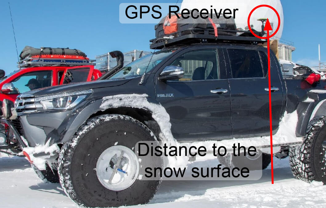
The elevation of ice sheets changes due to climate change, and satellite altimetry is the preferred tool for measuring ice sheet-wide height changes. In situ validation is needed to ensure the quality of the observed elevation changes, but the cost often limits the amount of in situ data which can be collected. As more tourists are accessing the ice sheets, citizen science might provide in situ data in an environmentally friendly and cost-efficient way. Here, we investigate the opportunistic kinematic global positioning system (GPS) profiles across the Greenland ice sheet, collected by the American-Icelandic expedition on the Greenlandic icecap 2018. The collected GPS data are in good agreement with the widely used NASA’s Operation IceBridge Airborne LiDAR data measured within ± 10 days, with an average difference of 10.7 cm ± 11.7 cm. The main difference is attributed to changes in the compaction of the snow while driving and changes in the tires’ pressure. The kinematic GPS data are then compared with data from the European Space Agency’s CryoSat-2 mission. Here, an average bias of 92.3 cm ± 65.7 cm in the two records is observed between the spring CryoSat-2 and the truck GPS data obtained largely in the dry-snow zone. This suggests that the surface penetration of Ku-band radar on the Greenland ice sheet and the observed magnitude are consistent with the literature. Finally, we compared the 2018 GPS data to a profile obtained in 2005 near Kangerlussuaq, West Greenland. Here, the records show an average ice-elevation decrease of 9 m, with peaks at 26 m. These results show that the citizen science kinematic GPS data can provide high-resolution data necessary for the validation of satellite altimetry, with the added benefit of potential direct sampling properties of the surface and firn. Linking up with citizen-science expeditions is a beneficial way of providing cost-effective satellite validations and may also have a societal impact by involving more people in the climate monitoring of ice sheets.
How to Cite
Share
Copyright (c) 2021 Andreas Stokholm, Sine M. Hvidegaard, Rene Forsberg, Sebastian B. Simonsen
This work is licensed under a Creative Commons Attribution 4.0 International License.
Funding
None declared.Downloads
An annual collection of articles submitted to GEUS Bulletin, published throughout 2021.
Cover photo: Wehrlé et al. 2022 (DOI:10.34194/geusb.v47.5284).
References
-
ACS Team & MSSL Team. 2015: CryoSat ground segment, instrument processing facility – L2 products format specification (L2-FMT). Baseline C version. Advanced Computer Systems, Doc. No.: CS-RS-ACS-GS-5123, 98 pp. https://earth.esa.int/web/guest/missions/cryosat/ipf-baseline/-/article/cryosat-ground-segment-instrument-processing-facility-l2-l2-products-format-specification-l2-fmt-6636
-
Ahlstrøm, A.P. et al. 2008: A new programme for monitoring the mass loss of the Greenland ice sheet. Geological Survey of Denmark and Greenland Bulletin 15, 61–64. https://doi.org/10.34194/geusb.v15.5045
-
Bouzinac, C. 2012: CryoSat Product Handbook. Report no., ESRIN ESA and Mullard Space Science Laboratory – University College London, ESA Esrin, Frascati, Italy.
-
Fausto, R.S., van As, D. & PROMICE project team. 2012: Ablation observations for 2008–2011 from the programme for monitoring of the Greenland ice sheet, PROMICE. Geological Survey of Denmark and Greenland Bulletin 26, 73–76. https://doi.org/10.34194/geusb.v26.4765
-
Forsberg, R., Sørensen, L. & Simonsen, S. 2017: Greenland and Antarctica ice sheet mass changes and effects on global sea level. In: Cazenave, A. et al. (eds): Integrative study of the mean sea level and its components. Space Sciences Series of ISSI 58, 91–106. https://doi.org/10.1007/978-3-319-56490-6_5
-
Howat, I.M., Negrete, A. & Smith, B.E. 2014: The Greenland Ice Mapping Project (GIMP) land classification and surface elevation datasets. The Cryosphere Discussions 8(1), 453–478. https://doi.org/10.5194/tcd-8-453-2014
-
Khan, S.A., Aschwanden, A., Bjørk, A.A., Wahr, J., Kjeldsen, K.K. & Kjær, K.H. 2015: Greenland ice sheet mass balance: a review. Reports on Progress in Physics 78(4), 046801. https://doi.org/10.1088/0034-4885/78/4/046801
-
Krabill, W., et al. 2000: Greenland ice sheet: high-elevation balance and peripheral thinning. Science 289(5478), 428–430. https://doi.org/10.1126/science.289.5478.428
-
Martin, C.F., Krabill, W.B., Manizade, S.S., Russell, R.L., Sonntag, J.G., Swift, R.N. & Yungel, J.K. 2012: Airborne topographic mapper calibration procedures and accuracy assessment. Nasa Technical Memorandum, TM–2012-215891 (February). Goddard Space Flight Center Greenbelt, Maryland, USA.
-
Nilsson, J. et al. 2015: Greenland 2012 melt event effects on Cryosat-2 radar altimetry. Geophysical Research Letters 42(10), 3919–3926. https://doi.org/10.1002/2015gl063296
-
Remy, F., Flament, T., Michel, A. & Blumstein, D. 2015: Envisat and SARAL/AltiKa observations of the Antarctic ice sheet: a comparison between the Ku-band and Ka-band. Marine Geodesy 38(suppl. 1), 510–521. https://doi.org/10.1080/01490419.2014.985347
-
Seitz, B., Mavrocordatos, C., Rebhan, H., Nieke, J., Klein, U., Borde, F. & Berruti, B. 2010: The sentinel-3 mission overview. International Geoscience and Remote Sensing Symposium (IGARSS), Honolulu, Hawaii, 25–30 July 2010, 5650772, 4208–4211. https://doi.org/10.1109/igarss.2010.5650772
-
Shepherd, A., et al. 2018: Mass balance of the Antarctic ice sheet from 1992 to 2017. Nature 558, 219–222. https://doi.org/10.1038/s41586-018-0179-y
-
Simonsen, S.B. & Sørensen, L.S.L. 2017: Implications of changing scattering properties on Greenland ice sheet volume change from Cryosat-2 altimetry. Remote Sensing of Environment 190, 207–216. https://doi.org/10.1016/j.rse.2016.12.012
-
Skourup, H., Barletta, V.R., Einarsson, I., Forsberg, R., Haas, C., Helm, V., Hendricks, S., Hvidegaard, S.M. & Sørensen, L.S. 2013: ESA CryoVEx 2011: airborne field campaign with ASIRAS radar, EM introduction sounder and laser scanner. DTU Space, Lyngby, Denmark, Technical Report 1, 120 pp.
-
Skourup, H., Einarsson, I., Forsberg, R., Haas, C., Helms, V., Hvidegaard, S.M., Nilsson, J., Olesen, A.V. & Olesen, A.K. 2012: ESA CryoVEx 2012: Airborne field campaign with ASIRAS radar, EM introduction sounder and laser scanner. DTU Space, Lyngby, Denmark, Technical Report 2, 105 pp.
-
Slater, T., Shepherd, A., McMillan, M., Armitage, T.W., Otosaka, I. & Arthern, R.J. 2019: Compensating changes in the penetration depth of pulse-limited radar altimetry over the Greenland ice sheet. IEEE Transactions on Geoscience and Remote Sensing 57(12), 9633–9642. https://doi.org/10.1109/tgrs.2019.2928232
-
Sørensen, L.S., Simonsen, S.B., Forsberg, R., Khvorostovsky, K., Meister, R. & Engdahl, M.E. 2018a: 25 years of elevation changes of the Greenland Ice Sheet from ERS, Envisat, and CryoSat-2 radar altimetry. Earth and Planetary Science Letters 495, 234–241. https://doi.org/10.1016/j.epsl.2018.05.015
-
Sørensen, L.S., et al. 2018b: Validation of CryoSat-2 SARIn data over Austfonna ice cap using airborne laser scanner measurements. Remote Sensing 10(9), 1354, 12 pp. https://doi.org/10.3390/rs10091354
-
Studinger, M. 2018: IceBridge ATM L2 Icessn elevation, slope, and roughness, Version 2. 2018 data, data set ID: ILATM2. https://doi.org/10.5067/CPRXXK3F39RV
-
Studinger, M., Koenig, L., Martin, S. & Sonntag, J. 2010: Operation icebridge: using instrumented aircraft to bridge the observational gap between icesat and icesat-2. International Geoscience and Remote Sensing Symposium (IGARSS), Honolulu, Hawaii, 25–30 July 2010, 5650555, 1918–1919. https://doi.org/10.1109/IGARSS.2010.5650555
-
Ulaby, F.T. & Stiles, W.H. 1981: Dielectric properties of snow. pp. 91–103. Lawrence, KS: Remote Sensing Laboratory, University of Kansas Center Research Inc.

