
How to Cite


Share
Copyright (c) 2020 Kristian Svennevig, Gregor Lützenburg, Marie K. Keiding, Stig Asbjørn Schack Pedersen

This work is licensed under a Creative Commons Attribution 4.0 International License.
Abstract
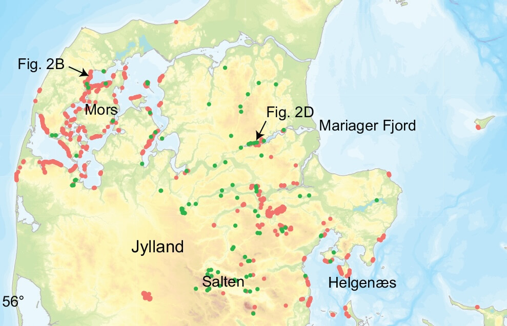
The process of coastal erosion is well known to the public and decision-makers in Denmark; however, there is little awareness of the risks posed by larger landslides. Only a few scientific studies investigate landslides in Denmark, and as a result, the country is underrepresented in international landslide inventories. Here, we present a systematically produced preliminary landslide inventory based on digital elevation models and high-resolution orthophotos. So far, the preliminary inventory documents 3026 morphological expressions of landslides close to the coast and inland, showing that landslides are more widespread in Denmark than previously recognised. A number of these landslides are near buildings and infrastructure. This paper therefore highlights the potential for geohazardous landslides to occur in Denmark on a national scale and discusses some of the implications. Two of the major questions arising from this study are (1) how to approach potential geohazards in a country with no framework or precedence for landslide hazard and risk management and (2) how landslides and associated risk in Denmark will evolve under a changing climate.
How to Cite
Share
Copyright (c) 2020 Kristian Svennevig, Gregor Lützenburg, Marie K. Keiding, Stig Asbjørn Schack Pedersen
This work is licensed under a Creative Commons Attribution 4.0 International License.
Downloads
References
-
Andersen, S.A. 1957: De jyske kildedale og deres problemer. Meddelelser Dansk Geologisk Forening 13, 438–440.
-
Burns, W.J. & Madin, I.P. 2009: Protocol for inventory mapping of landslide deposits from light detectIon and ranging (lidar) imagery. Oregon Department of Geology and Mineral Industries Special Paper 42, 30 p.
-
Busby, J.P., Gourry, J.C., Senfaute, G., Pedersen, S.A.S. & Mortimore, R. 2002: Can we predict coastal cliff failure with remote, indirect measurements? In: Jakeways, J. & McInnes, R. (eds): Instability, planning and management, 203–208. London: Thomas Telford. https://doi.org/10.1680/ipamssstgmp.31326" target="_base">https://doi.org/10.1680/ipamssstgmp.31326
-
Cruden, D.M. & Varnes, D.J. 1996: Landslides types and processes. In: Turner, A.K. & Schuster, R.L. (eds): Landslides: investigation and mitigation. Transportation Research Board Special Report 247, 36–75.
-
Gariano, S.L. & Guzzetti, F. 2016: Landslides in a changing climate. Earth-Science Reviews 162, 227–252. https://doi.org/10.1016/j.earscirev.2016.08.011" target="_base">https://doi.org/10.1016/j.earscirev.2016.08.011
-
Hansen, K., 1959. Saltenprofilet. Meddelelser Dansk Geologisk Forening 14, 1–7.
-
Hansen, K., 1975. The Salten Valley A geomorphological analysis. Dansk Geologisk Forenings Årskrift for 1974, 5–23.
-
Herrera, G. et al. 2018: Landslide databases in the Geological Surveys of Europe. Landslides 15, 359–379. https://doi.org/10.1007/s10346-017-0902-z" target="_base">https://doi.org/10.1007/s10346-017-0902-z
-
Highland, L., 2004: Landslide types and processes. Fact Sheet 2004–3072. Reston: US Geological Survey. https://doi.org/10.3133/fs20043072" target="_base">https://doi.org/10.3133/fs20043072
-
Hungr, O., Leroueil, S. & Picarelli, L. 2014: The Varnes classification of landslide types, an update. Landslides 11, 167–194. https://doi.org/10.1007/s10346-013-0436-y" target="_base">https://doi.org/10.1007/s10346-013-0436-y
-
Hutchinson, J.N. 2002: Chalk flows from the coastal cliffs of northwest Europe. Reviews in Engineering Geology 15, 257–302. https://doi.org/10.1130/reg15-p257" target="_base">https://doi.org/10.1130/reg15-p257
-
IPCC. 2014. Climate Change 2014: Synthesis Report. Contribution of Working Groups I, II and III to the Fifth Assessment Report of the Intergovernmental Panel on Climate Change. Geneva, Switzerland: IPCC, 151 pp.
-
Lykke-Andersen, H & Sørensen, P.B. 2018: Aabenraa-modellen: et landskab formet af jordskred. Geoviden 3, 16–19.
-
Mateos, R.M. et al. 2020: Integration of landslide hazard into urban planning across Europe. Landscape and Urban Planning 196, 103740. https://doi.org/10.1016/j.landurbplan.2019.103740" target="_base">https://doi.org/10.1016/j.landurbplan.2019.103740
-
Nadim, F., Pedersen, S.A.S., Schmidt-Thomé, P., Sigmundsson, F. & Engdahl, M. 2008: Natural hazards in Nordic countries. Episodes 31, 176–184. https://doi.org/10.18814/epiiugs/2008/v31i1/024" target="_base">https://doi.org/10.18814/epiiugs/2008/v31i1/024
-
Pedersen, S.A.S. 1987: Comparative studies of gravity tectonics in Quaternary sediments and sedimentary rocks related to fold belts. Geological Society (London) Special Publications 29, 165–179. https://doi.org/10.1144/gsl.sp.1987.029.01.14" target="_base">https://doi.org/10.1144/gsl.sp.1987.029.01.14
-
Pedersen, S.A.S. 2005: Structural analysis of the Rubjerg Knude Glaciotectonic Complex, Vendsyssel, northern Denmark, Geological Survey of Denmark and Greenland Bulletin 8, 192 pp. https://doi.org/10.34194/geusb.v8.4848" target="_base">https://doi.org/10.34194/geusb.v8.4848
-
Pedersen, S.A.S. 2012: Rockfalls at chalk cliffs in northern Europe. In: Eberhardt, E. et al. (eds): Landslides and engineered slopes: protecting society through improved understanding, 1127–1132. London: Taylor & Francis Group.
-
Pedersen, S.A.S. & Damholt, T. 2012: Cliff collapse at Stevns Klint, south-east Denmark. Geological Survey of Denmark and Greenland Bulletin 26, 33–36. https://doi.org/10.34194/geusb.v26.4745" target="_base">https://doi.org/10.34194/geusb.v26.4745
-
Pedersen, S.A.S., Foged, N. & Frederiksen, J. 1989: Extent and economic significance of landslides in Denmark, Faroe Islands and Greenland. In: Brabb, H. (ed): Landslides: extent and economic significance, 153–156. Rotterdam: Balkema.
-
Pedersen, S.A.S. & Gravesen, P. 2009: Structural development of Maglevandsfald: a key to understanding the glaciotectonic architecture of Møns Klint, SE Denmark. Geological Survey of Denmark and Greenland Bulletin 17, 29–32. https://doi.org/10.34194/geusb.v17.5007" target="_base">https://doi.org/10.34194/geusb.v17.5007
-
Pedersen, S.A.S. & Møller, I. 2004: Prediction and risk evaluation of chalk cliff collapse: the PROTECT project. Geological Survey of Denmark and Greenland Bulletin 4, 89–92. https://doi.org/10.34194/geusb.v4.4793" target="_base">https://doi.org/10.34194/geusb.v4.4793
-
Prior, D.B. 1973: Coastal landslides and swelling clays at Røsnæs, Denmark. Danish Journal of Geography 72, 45–48. https://doi.org/10.1080/00167223.1973.10649024" target="_base">https://doi.org/10.1080/00167223.1973.10649024
-
Prior, D.B. 1977: Coastal mudslide morphology and processes on eocene clays in Denmark. Danish Journal of Geography 76, 14–33. https://doi.org/10.1080/00167223.1977.10649071" target="_base">https://doi.org/10.1080/00167223.1977.10649071
-
Prior, D.B. & Eve, R.B. 1975: Coastal landslide morphology at Røsnæs, Denmark. Danish Journal of Geography 74, 12–20. https://doi.org/10.1080/00167223.1975.10649043" target="_base">https://doi.org/10.1080/00167223.1975.10649043
-
SDFE. 2020: Denmark’s Elevation Model, Styrelsen for Dataforsyning og Effektivisering, https://sdfe.dk/hent-data/danmarks-hoejdemodel/" target="_base">https://sdfe.dk/hent-data/danmarks-hoejdemodel/
-
Slaughter, S.L., Burns, W.J., Mickelson, K.A., Jacobacci, K.E., Biel, A., Contreras, T.A. & Washington, L.E.G. 2017: Protocol for landslide inventory mapping from lidar data in Washington State. Washington Geological Survey Bulletin 82, 1–27.
-
Svennevig, K. 2019: Preliminary landslide mapping in Greenland. Geological Survey of Denmark and Greenland Bulletin 43, e2019430207. https://doi.org/10.34194/geusb-201943-02-07" target="_base">https://doi.org/10.34194/geusb-201943-02-07

