How to Cite


Share
Copyright (c) 2008 John Tychsen, Ole Geertz-Hansen, Frands Schjøth

This work is licensed under a Creative Commons Attribution 4.0 International License.
Abstract
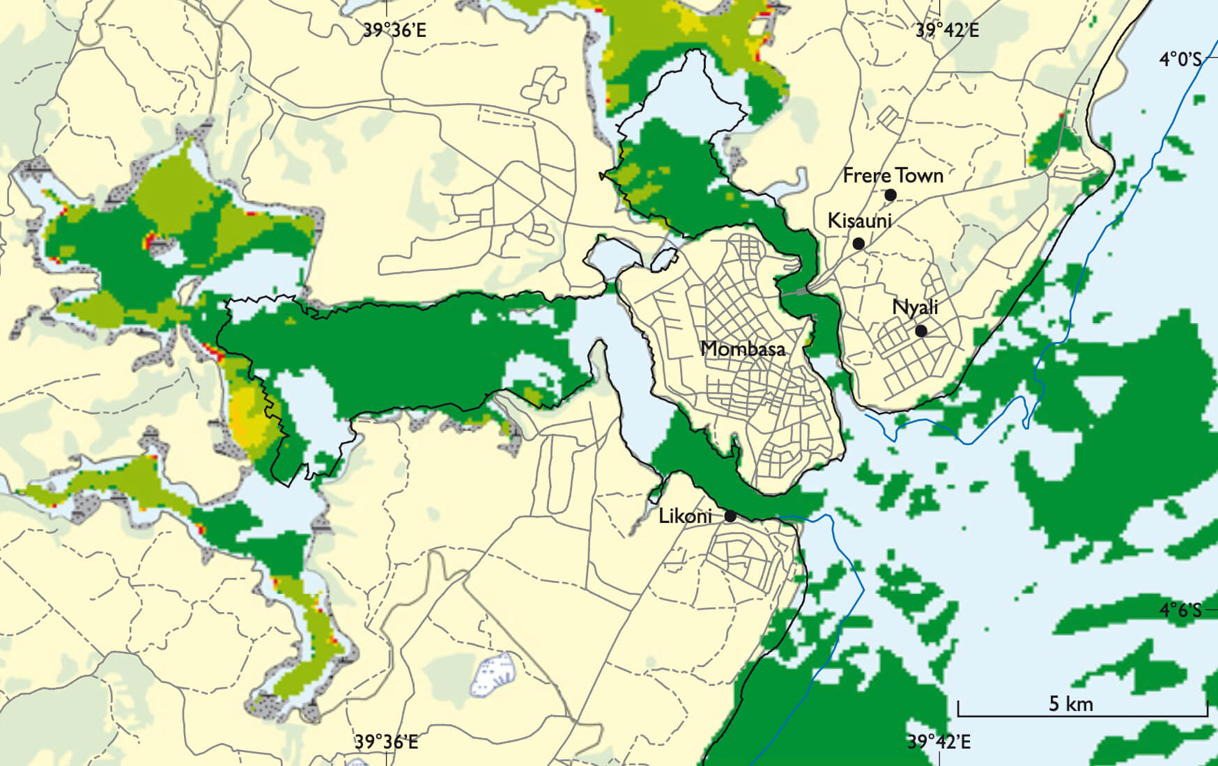
On 26 December 2004, the eastern part of the Indian Ocean was hit by a tremendous tsunami created by a submarine earthquake of magnitude 9.1 on the Richter scale off the west coast of Sumatra. The tsunami also reached the western part of the Indian Ocean, including the coastal areas of eastern Africa. Along the coast of Kenya (Figs 1, 2) it resulted in a sudden increase in water level comparable to a high tide situation. This rather limited consequence was partly due to the great distance to the epicentre of the earthquake, and partly due to the low tide at the time of the impact. Hence the reefs that fringe two thirds of the coastline reduced the energy of the tsunami waves and protected the coastal areas. During the spring of 2005, staff members from the Geological Survey of Denmark and Greenland (GEUS) carried out field work related to the project KenSea – development of a sensitivity atlas for coastal areas of Kenya (Tychsen 2006; Tychsen et al. 2006). Local fishermen and authorities often asked what would have been the effect if the tsunami had hit the coastal area during a high tide, and to answer the question GEUS and the Kenya Marine and Fisheries Research Institute (KMFRI) initiated a tsunami damage projection project. The aim was to provide an important tool for contingency planning by national and local authorities in the implementation of a national early warning strategy. The tsunami damage projection project used the database of coastal resources – KenSeaBase – that was developed during the KenSea project. The topographical maps of Kenya at a scale of 1:50 000 have 20 m contour lines, which is insufficient for the tsunami run-up simulation modelling undertaken by the new tsunami project. Therefore new sets of aerial photographs were obtained, and new photogrammetric maps with contour lines with an equidistance of 1 m were drawn for a 6–8 km broad coastal zone. The tsunami modelling is based on the assumption that the height of a future tsunami wave would be comparable with the one that reached the coastal area of Kenya in December 2004. Based on the regional geology of the Indian Ocean, it appears that the epicentre for a possible future earthquake that could lead to a new tsunami would most likely be situated in the eastern part of the ocean. Furthermore, based on a seismological assessment it has been estimated that the largest tsunami that can be expected to reach eastern Africa would have a 50% larger amplitude than the 2004 tsunami. It was therefore decided to carry out the simulation modelling with a tsunami wave similar to that of the 2004 event, but with the wave reaching the coast at the highest astronomical tide (scenario 1) and a worst case with a 50% larger amplitude (scenario 2: Fig. 3). The 2004 tsunami documented that the coastal belt of mangrove swamps provided some protection to the coastline by reducing the energy of the tsunami. Hence we included in this study a scenario 3 (Fig. 4), in which the mangrove areas along the coastline were removed. Maps for the three scenarios have been produced and show the areas that would be flooded, the degree of flooding, and the distribution of buildings such as schools and hospitals in the flooded areas. In addition, the force and velocity of the wave were calculated (COWI 2006).
How to Cite
Share
Copyright (c) 2008 John Tychsen, Ole Geertz-Hansen, Frands Schjøth
This work is licensed under a Creative Commons Attribution 4.0 International License.
Downloads
Edited by Ole Bennike and A.K. Higgins
This Review of Survey activities presents a selection of 22 papers reflecting the wide spectrum of activities of the Geological Survey of Denmark and Greenland, from the microscopic to the plate-tectonic level.
The Survey's activities in Denmark are illustrated by 13 articles. Five of them deal with petroleum-related [...]