How to Cite


Share
Copyright (c) 2008 Flemming Jørgensen, Peter B E Sandersen

This work is licensed under a Creative Commons Attribution 4.0 International License.
Abstract
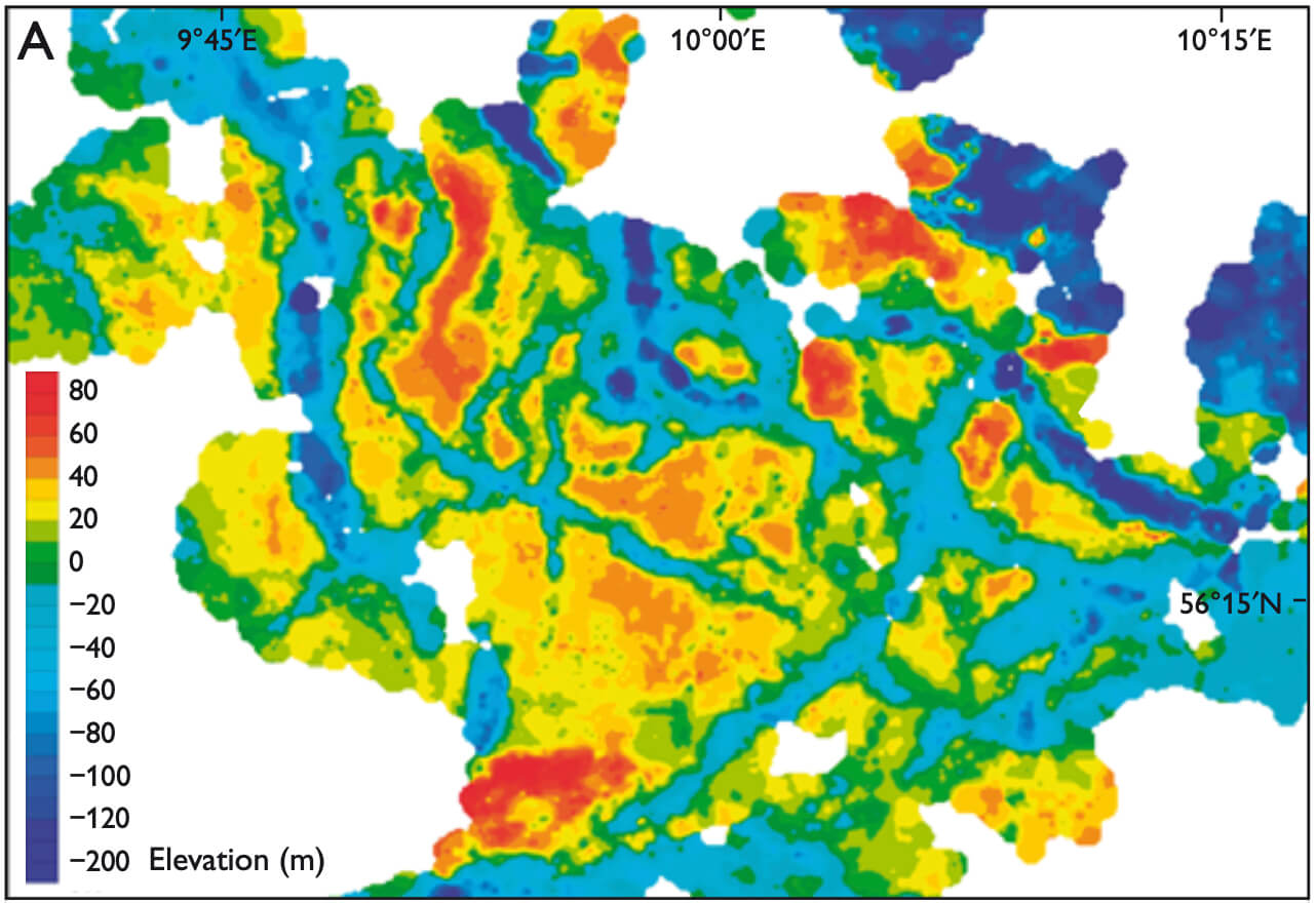
Tunnel valleys eroded by subglacial meltwater underneath the Late Weichselian ice sheet are a common feature in the Danish landscape (Ussing 1907; Smed 1998). They occur as undulating elongate depressions with hollows and thresholds and without continuously descending floors. The valleys rise tens of metres before terminating in large outwash fans, primarily along the Main Stationary Line in Jylland, but also along younger ice-margin lines formed shortly after the Last Glacial Maximum. The meltwater was driven by hydrostatic pressure gradients below the glacier towards its margin leading to subglacial erosional features, partly in the form of valleys. The term ‘tunnel valley’ was first used by Madsen (1921), who referred to tunnel-like structures below glaciers that were expected to have carried the meltwater. Worldwide, this term is used for subglacially eroded valleys; however, other terms such as ‘tunnel channel’ and ‘incision’ are also widely used for such valleys. There is general consensus that subglacial meltwater is the primary causative agent that has eroded the tunnel valleys (O’Cofaigh 1996; Huuse & Lykke-Andersen 2000; Jørgensen & Sandersen 2006). The subglacial origin is indicated by: (1) abrupt terminations at former ice margins and the association with the large outwash plains, (2) irregular longitudinal profiles, (3) the occurrence of small channels and eskers in the valleys, and (4) the non-meandering and non-dendritic appearance of the relatively straight-segmented valleys. The exact mode of meltwater erosion remains, however, poorly understood. Valleys are present not only in the landscape; they are also found buried in the subsurface. In Denmark, buried valleys have occasionally been described on the basis of borehole data and early geoelectrical methods (e.g. Sorgenfrei & Berthelsen 1954; Lykke-Andersen 1973; Binzer & Stockmarr 1994). Based on the large amount of newly collected hydrogeophysical data in Denmark, it has recently become possible to define such valleys as tunnel valleys and to acknowledge their wide distribution in the subsurface (Sandersen & Jørgensen 2003; Jørgensen et al. 2005; Jørgensen & Sandersen 2006). Analysis of these data has revealed dense networks of tunnel valleys and has significantly improved our understanding of their distribution, geometry and sedimentary infill. In the following, we review this work and identify new perspectives for the interpretation of the Quaternary succession in Denmark. The work was initiated in 1998 by the former Danish counties (amter), and is currently continued by the Geological Survey of Denmark and Greenland and the ‘miljøcentre’ (environment centres). As part of this project, the buried valleys are continuously being mapped as new data are collected.
How to Cite
Share
Copyright (c) 2008 Flemming Jørgensen, Peter B E Sandersen
This work is licensed under a Creative Commons Attribution 4.0 International License.
Downloads
Edited by Ole Bennike and A.K. Higgins
This Review of Survey activities presents a selection of 22 papers reflecting the wide spectrum of activities of the Geological Survey of Denmark and Greenland, from the microscopic to the plate-tectonic level.
The Survey's activities in Denmark are illustrated by 13 articles. Five of them deal with petroleum-related [...]