How to Cite


Share
Copyright (c) 2006 Jeroen A M van Gool, Sandra Piazolo

This work is licensed under a Creative Commons Attribution 4.0 International License.
Abstract
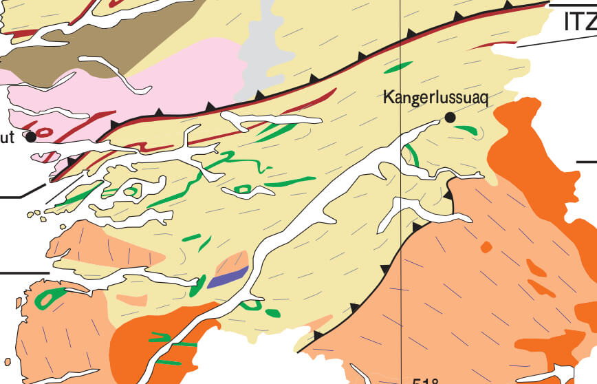
In this contribution we present data collected by more than 50 international geologists involved in geological mapping and research projects in the Nagssugtoqidian orogen of West Greenland, organised by the Geological Survey of Denmark and Greenland and the Danish Lithosphere Centre. Using a geographical information system (GIS) as a framework for visualisation and analysis of structural and lithological data, it is now possible to give a unique overview of thousands of data points, employed here within a study area of approximately 160 × 180 km in the central and northern Nagssugtoqidian orogen. The GIS methodology allows comparison, integration and analysis of datasets in terms of subject, space, and scale. This is extremely helpful in the recognition of geological patterns, such as terrain or domain boundaries and map-scale structures. Analysis of the available structural data shows clear differences in deformation patterns between the core and the northern segment of the Nagssugtoqidian orogen. One of the most prominent features is the ENE-striking Nordre Strømfjord shear zone, which transects the orogen from the coast to the Inland Ice. The data also clearly document a change from predominantly steeply dipping, ENE–WSW-trending fabrics and large, elongate structural domains in the core of the orogen, to large, open fold patterns and moderately to shallowly dipping fabrics in smaller structural domains in the north.
How to Cite
Share
Copyright (c) 2006 Jeroen A M van Gool, Sandra Piazolo
This work is licensed under a Creative Commons Attribution 4.0 International License.
Downloads
Editors: A.A. Garde and F. Kalsbeek
Central West Greenland exposes a large region of Archaean continental crust that was rifted and subsequently reworked in the Palaeoproterozoic during the Nagssugtoqidian and Rinkian orogenies. The southern margin of the Nagssugtoqidian orogen with its deformed Kangâmiut dykes is a classic example of an orogenic [...]