How to Cite
Share
Abstract
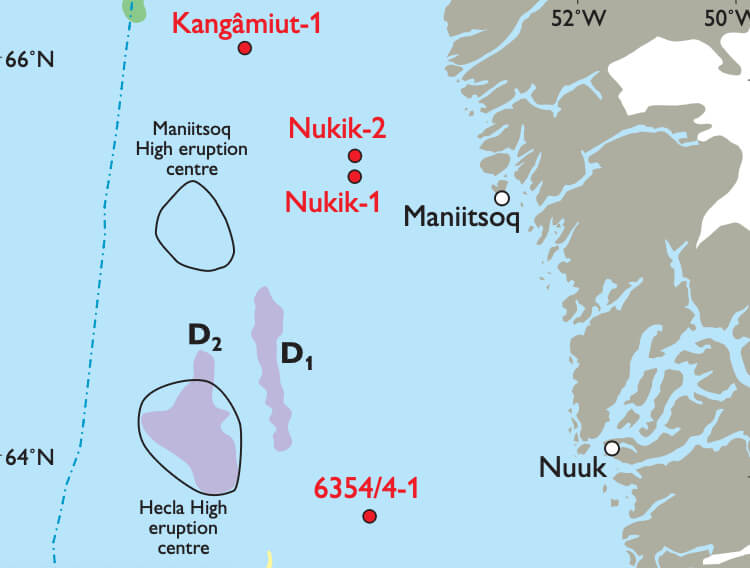
Although the structural framework of the subsurface offshore West Greenland has been well documented based on comprehensive seismic analysis (cf. Dalhoff et al. 2003), the stratigraphy of the region is less well known. The oldest documented sedimentary rocks drilled offshore West Greenland are Santonian sandstones reached at TD in the 6354/4-1 well (Fig. 1) although reworked palynomorphs of Carboniferous, Triassic and Jurassic (Kimmeridgian) age have been reported from a number of wells in the region. In order to obtain better constraints on the pre-Upper Cretaceous stratigraphy, a preliminary screening was undertaken to identify inversion structures and erosional canyons where such deeper stratigraphic levels crop out at the seabed (Nielsen et al. 2001). Sea-floor sampling at selected sites between 62° and 67°N (Fig. 1) was undertaken during the summers of 2003 and 2004. Other objectives of these cruises were to seek direct evidence of active petroleum systems, to establish further constraints on tectonic and stratigraphic models, and to obtain a better understanding of the Neogene and Pleistocene history of the region (Dalhoff et al. 2005). The most promising seabed features identified by Nielsen et al. (2001) were investigated in more detail using a wide range of techniques in order to optimise sampling positions. In 2003, these techniques included echo sounder, side-scan sonar, single-channel seismic and video inspection before sampling either by dredge, gravity corer, or by video-controlled grab. In 2004, comprehensive data acquisition with a deep-water sparker system was undertaken before sampling by dredge or gravity corer, supplemented by grab samples at selected stations.
How to Cite
Share
Downloads
Editors: Martin Sønderholm & A.K. Higgins
The Review of Survey activities presents a selection of 15 papers reflecting the wide spectrum of activities of the Geological Survey of Denmark and Greenland, from the microscopic to the plate tectonic level.
Activities in Denmark: The Survey's field of activities in Denmark is illustrated by four papers on [...]


