How to Cite


Share

This work is licensed under a Creative Commons Attribution 4.0 International License.
Abstract
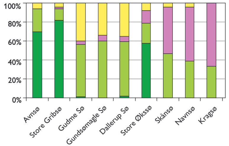
Pollen records from lake sediments have a great potential for providing information on the quantitative composition of past vegetation and land cover in the surrounding landscape. This can contribute to a better understanding of the development of the cultural landscape and interactions between human impact on the landscape and natural conditions like soil and climate. A good understanding of the history of cultural landscapes is necessary for choosing appropriate management strategies for areas dependent on cultural impact, such as heaths, meadows and dry pastures. It is also important for archaeological research concerning utilisation of the landscape in earlier periods. Furthermore, quantitative reconstructions are relevant for climate research. Here they can be used to test climate models, since model predictions of past climate can be translated into past vegetation, which can then be compared to pollen-based reconstructions. Past vegetation cover is also a necessary input to climate models, as it influences albedo, evapotranspiration and carbon storage and cycling. Quantifying vegetation from fossil pollen samples requires a detailed understanding of the way vegetation is reflected in pollen assemblages, including the approximate size of the area of vegetation represented. The relationship between pollen and vegetation is complicated by the fact that different plant species produce different amounts of pollen, and that pollen types are dispersed differently in the atmosphere, depending on their size, shape and weight. These pressing challenges in pollen analysis have attracted much attention in recent years. Models have been developed to describe and simulate species specific pollen dispersal, to quantitatively relate pollen proportions to plant abundance, as well as estimate pollen productivity and to quantify the pollen source area of different types of basins (Parsons & Prentice 1981; Prentice & Parsons 1983; Prentice 1985; Sugita 1993, 1994; Sugita et al. 1997, 1999; Broström 2002; Bunting et al. 2004). The Geological Survey of Denmark and Greenland (GEUS) has in recent years contributed to the development and validation of such models through the project AGRAR 2000 (Odgaard 1999; Nielsen 2003), where quantitative estimates of past land cover in different regions of Denmark were one of the main objectives, and through participation in the international research network POLLANDCAL (POLlen LANdscape CALibration), funded by NORDFORSK (Nordic Research Board), which focuses on further model development, validation and application.
How to Cite
Share
Downloads
Editors: Martin Sønderholm & A.K. Higgins
The Review of Survey activities presents a selection of 18 papers reflecting the wide spectrum of activities of the Geological Survey of Denmark and Greenland, from the microbial to the plate tectonic level.
Activities in Denmark: The Survey's activities in Denmark are documented by 11 papers. The main themes [...]