How to Cite


Share

This work is licensed under a Creative Commons Attribution 4.0 International License.
Abstract
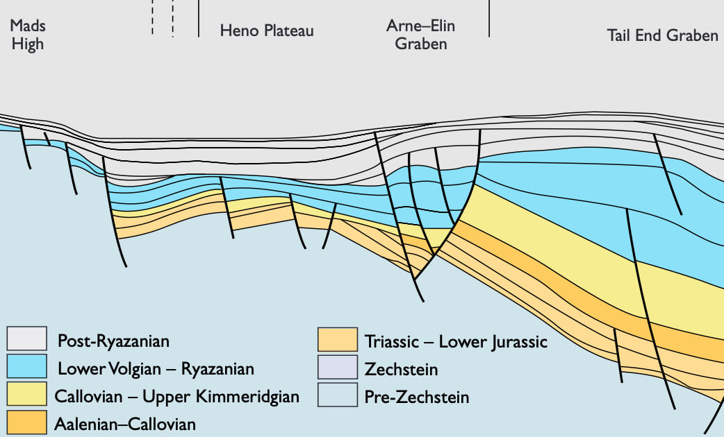
Paralic and shallow marine sandstones were deposited in the Danish Central Graben during Late Jurassic rifting when half-grabens were developed and the overall eustatic sea level rose. During the Kimmeridgian, an extensive plateau area consisting of the Heno Plateau and the Gertrud Plateau was situated between two highs, the Mandal High to the north, and the combined Inge and Mads Highs to the west. These highs were land areas situated on either side of the plateaus and supplied sand to the Gertrud and Heno Plateaus. Two graben areas, the Feda and Tail End Grabens, flanked the plateau area to the west and east, respectively. The regressive–transgressive succession consists of intensely bioturbated shoreface sandstones, 25–75 m thick. Two widespread unconformities (SB1, SB2) are recognised on the plateaus, forming the base of sequence 1 and sequence 2, respectively. These unconformities were created by a fall in relative sea level during which rivers may have eroded older shoreface sands and transported sediment across the Heno and Gertrud Plateaus, resulting in the accumulation of shoreface sandstones farther out in the Feda and Tail End Grabens, on the south-east Heno Plateau and in the Salt Dome Province. During subsequent transgression, fluvial sediments were reworked by high-energy shoreface processes on the Heno and Gertrud Plateaus, leaving only a lag of granules and pebbles on the marine transgressive surfaces of erosion (MTSE1, MTSE2).
The sequence boundary SB1 can be traced to the south-east Heno Plateau and the Salt Dome Province, where it is marked by sharp-based shoreface sandstones. During low sea level, erosion occurred in the southern part of the Feda Graben, which formed part of the Gertrud and Heno Plateaus, and sedimentation occurred in the Norwegian part of the Feda Graben farther to the north. During subsequent transgression, the southern part of the Feda Graben began to subside, and a succession of backstepping back-barrier and shoreface sediments, 90 m thick, was deposited. In the deep Tail End and Feda Grabens and the Salt Dome Province, sequence boundary SB2 is developed as a conformity, indicating that there was not a significant fall in relative sea level in these grabens, probably as a result of high subsidence rates. Backstepping lower shoreface sandstones overlie SB2 and show a gradual fining-upwards to offshore claystones that are referred to the Farsund Formation. On the plateaus, backstepping shoreface sandstones of sequence 2 are abruptly overlain by offshore claystones, indicating a sudden deepening and associated cessation of sand supply, probably caused by drowning of the sediment source areas on the Mandal, Inge and Mads Highs. During the Volgian, the Gertrud Plateau began to subside and became a graben. During the Late Kimmeridgian – Ryazanian, a long-term relative sea-level rise resulted in deposition of a thick succession of offshore claystones forming highstand and transgressive systems tracts on the Heno Plateau, and in the Gertrud, Feda and Tail End Grabens.
How to Cite
Share
Downloads
Editors: Jon R. Ineson and Finn Surlyk
The Jurassic rocks of Denmark and East Greenland record the evolution of two discrete portions of the Mesozoic rift complex, now separated by the North Atlantic Ocean. The Jurassic of Denmark and adjacent areas occurs mostly in the subsurface and research has thus focussed [...]