How to Cite


Share
Copyright (c) 2019 Björn Heincke, Robert Jackisch, Ari Saartenoja, Heikki Salmirinne, Sönke Rapp, Robert Zimmermann, Markku Pirttijärvi, Erik Vest Sörensen, Richard Gloaguen, Lisa Ek, Johan Bergström, Arto Karinen, Sara Salehi, Yuleika Madriz, Maarit Middleton

This work is licensed under a Creative Commons Attribution 4.0 International License.
Abstract
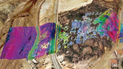
The use of Unmanned Aerial Systems (UAS), also known as drones, is becoming increasingly important for geological applications. Thanks to lower operational costs and ease of use, UAS offer an alternative approach to aircraft-based and ground-based geoscientific measurements (Colomina & Molina 2014). Magnetic and hyperspectral UAS surveys hold particular promise for mineral exploration, and several groups have recently published studies of magnetic data collected by UAS for such applications (Malehmir et al. 2017; Cunningham et al. 2018), although equivalent studies using hyperspectral data are still rare (Kirsch et al. 2018). Combining both techniques is particularly useful. Magnetic measurements play an important role in mineral exploration, since magnetisation in rocks is mainly associated with magnetite and other iron minerals, which can be used in mapping and targeting of mineral deposits (Dentith & Mudge 2014). Hyperspectral imaging (HSI) is a powerful exploration and mapping technique in areas where the rock surface is well-exposed, and where geological units and mineral compositions can be estimated from spectral features of the electromagnetic spectrum in the visual and infrared range.
How to Cite
Share
Copyright (c) 2019 Björn Heincke, Robert Jackisch, Ari Saartenoja, Heikki Salmirinne, Sönke Rapp, Robert Zimmermann, Markku Pirttijärvi, Erik Vest Sörensen, Richard Gloaguen, Lisa Ek, Johan Bergström, Arto Karinen, Sara Salehi, Yuleika Madriz, Maarit Middleton
This work is licensed under a Creative Commons Attribution 4.0 International License.
Downloads