 |
DATA ARTICLE | SHORT  |
The Rosenlund Catalogue: a GIS database of Quaternary zoological fauna in Denmark
Kristian K. Kjeldsen1  , Kim Aaris-Sørensen2, Anne B. Gotfredsen3 , Pernille Bangsgaard3 , Kasper L. Hansen3 , Kristian M. Gregersen4 , and Kurt H. Kjær2,3
Abstract
The Rosenlund Catalogue presents a digitised, Geographical Information System (GIS) data set of the Quaternary zoological fauna curated at the Natural History Museum of Denmark. The data set derives from the Quaternary Zoological Central Register and comprises 20 315 taxonomic entries linked to 6481 accessions collected between 1814 and 2022 across Denmark. Each entry is associated with contextual metadata including a journal number, locality (parish, district, county), excavation year, find context, dating method and chronozone classification. Spatial referencing is based on the pre-1970 parish division and georeferenced using ETRS89/UTM Zone 32N. The original relational database structure, consisting of linked contextual and taxonomic tables, was extracted, cleaned and migrated to interoperable formats (.xlsx and .gpkg). The resulting data set provides nationwide spatial coverage and standardised taxonomic and stratigraphic information. These data support research and heritage management applications in Quaternary zoology, archaeology, biostratigraphy, palaeoenvironmental reconstruction, and long-term biodiversity change.
Tabular abstract
| Geographical coverage | Denmark |
| Temporal coverage | Quaternary. Original data were collected 1814–2022. |
| Subject(s) | Quaternary zoology |
| Data format(s) | Data table of Quaternary zoological fauna, with spatial information of the find locations. Data table provided in .xlsx format. Point and polygon feature data provided as geopackage (.gpkg) files with attribute tables. The data consist of: The entire database archive in .xlsx and .gpkg formats (‘Rosenlund_v2p8 All’); the ‘Rosenlund_v2p8’ database in .gpkg format specific to the each of the Danish archaeological jurisdiction areas, identified through the suffix; the onshore archaeological jurisdiction areas in .gpkg format (‘Arkæologiske Ansvarsområder 2023’); the offshore archaeological jurisdiction areas in .gpkg format (‘Marinarkæologi Vest (MAV) Ansvarsområde’ and ‘Vikingeskibsmuseet Ansvarsområde’); Division of Danish parishes (Stednr. and sognekommuner) including offshore areas in .gpkg format (‘Parish Stednr Sognekommuner incl sea’). |
| Sample collection and analysis | Digitisation and GIS processing of historic data |
| Parameters | Zoological Museum’s Quaternary Zoological Collection journal number, and spatial information for the parish, district, county. |
| Related publications | Kjeldsen et al. 2026. https://doi.org/10.22008/FK2/B7GOPK |
| Potential application(s) for these data | Studies of faunal history and biodiversity change, human–animal interactions, climate and environmental reconstructions and biostratigraphy. |
Citation: Kjeldsen et al. 2026: GEUS Bulletin 62. 8431. https://doi.org/10.34194/rj5kn429
Copyright: GEUS Bulletin (eISSN: 2597-2154) is an open access, peer-reviewed journal published by the Geological Survey of Denmark and Greenland (GEUS). This article is distributed under a CC-BY 4.0 licence, permitting free redistribution, and reproduction for any purpose, even commercial, provided proper citation of the original work. Author(s) retain copyright.
Received: 25 Mar 2026; Revised: 02 Sep 2026; Accepted: 02 Sep 2026; Published: 28 Oct 2026
Competing interests and funding: The authors declare that they have no competing interests.
This study was supported by ArchaeoScience core facility at the Globe Institute.
*Correspondence: Kurtk@sund.ku.dk
Keywords: quaternary; zooarchaeological fauna; Denmark; geographical information system
Abbreviations:
BP: before present
DKC: Det Kvartærzoologiske Centralregister (Quaternary Zoological Central Register)
DOS: Disk Operating System
GIS: Geographical Information System
ICS: International Commission on Stratigraphy
IUGS: International Union of Geological Sciences
Z.M.K.: Zoological Museum København (Copenhagen)
ZM: Zoological Museum
Edited by: Harold Lovell (University of Portsmouth, UK)
Reviewed by: Youri van den Hurk (University Museum of Bergen, Norway), Sofie Folsach Hellerøe (Aarhus University, Denmark)
1 The Danish Quaternary zoological fauna collection
The Quaternary zoological fauna collection at the Natural History Museum Denmark, part of the University of Copenhagen (formerly the Zoological Museum [ZM]), Denmark, constitutes one of the most comprehensive national collections of archaeological and geological vertebrate remains in Europe. The scientific study of Quaternary vertebrate remains in Denmark formally began in 1814 with Professor Johannes H. Reinhardt, who initiated the systematic recording of zoological material. This followed the Oldsagskommissionen in 1807, which, by law, introduced the systematic registration of antiquities and the collection of artefacts in Denmark, including bones. From this initiative emerged several key institutions, including the Museum of Nordic Antiquities (later the National Museum of Denmark) and the Natural History Museum Denmark, as well as the parish boundaries (Sognebeskrivelsen), which form the basis for the present-day parish (sogn) and district (herred) system. Following Reinhardt’s death in 1845, Japetus Steenstrup continued and expanded this work, actively promoting the development of a national collection of subfossil and archaeological bone material. The subsequent merging of the Natural History Museum and the university collections under the University of Copenhagen consolidated responsibility for Quaternary zoological studies within the then ZM. Since the mid-19th century, the majority of faunal remains from the Kingdom of Denmark, including Iceland (until 1944), the Faroe Islands and Greenland have been submitted to the museum for identification and curation. Curator H. Winge should be credited with initiating a systematic registration procedure that formed the backbone of the collection’s documentation. This system was further developed by conservator Ulrik Møhl Hansen, who introduced the journal numbering system under curator Magnus Degerbøl in the 1940s. Later, curator K. Aaris-Sørensen and collection manager K. Rosenlund implemented an electronic registration system in the late 20th century, formalised in the Quaternary Zoological Central Register (DKC; Det Kvartærzoologiske Centralregister) database.
The collection currently comprises between 10 and 15 million individual specimens including both morphologically distinct and indeterminable bone fragments, which are related to 6481 separate accessions submitted to the collection. Here, we define an accession as an incoming archaeological or geological find or collection that has been given a journal number – referred to as the Z.M.K. (Zoological Museum København; i.e. Copenhagen) number. An accession can include a single find consisting of one specimen or a large find with numerous specimens. From all accessions, some 20 315 individual entries have been determined to species level or to a higher taxonomic level typically to genus or family and registered together with their respective metadata (Table 1).
The earliest data entry relates to material submitted in 1770, while the most recent entries date to 2022. The collection includes material recovered from archaeological excavations, geological exposures, peat bogs and wetlands, marine contexts, and stray finds from fields and construction activities. Find contexts span from the previous interglacials, including the Cromer-complex, Holstein and Eemian covering up to c. 850 000 year old material through the last Weichselian glaciation into the Holocene and more recent historical times. The material forms the empirical basis for research into faunal history and biodiversity change, human–animal interactions, climate and environmental reconstructions as well as biostratigraphy.
The temporal and spatial development of the Quaternary zoological collection in Denmark from the early 19th century to the present (N = 6481) is shown in Fig. 1 and demonstrates a gradual expansion from the scattered early records to the dense nationwide coverage of today. Looking at the annual accumulation of registrations, the modest activity in the 19th century is followed by strong growth in the mid- and late 20th century. Exploration of peat during the Second World War, while Denmark was occupied, increased the accession many fold to the collection. Key methodological and administrative milestones such as systematic accession protocols, Winge’s registration system, introduction of journal numbers (Curator Degerbøl) the establishment of the DKC database and later GIS implementation are indicated along the timeline (Fig. 1). Altogether, this timeline highlights how institutional development and research intensity shaped the growth of the collection over more than two centuries.
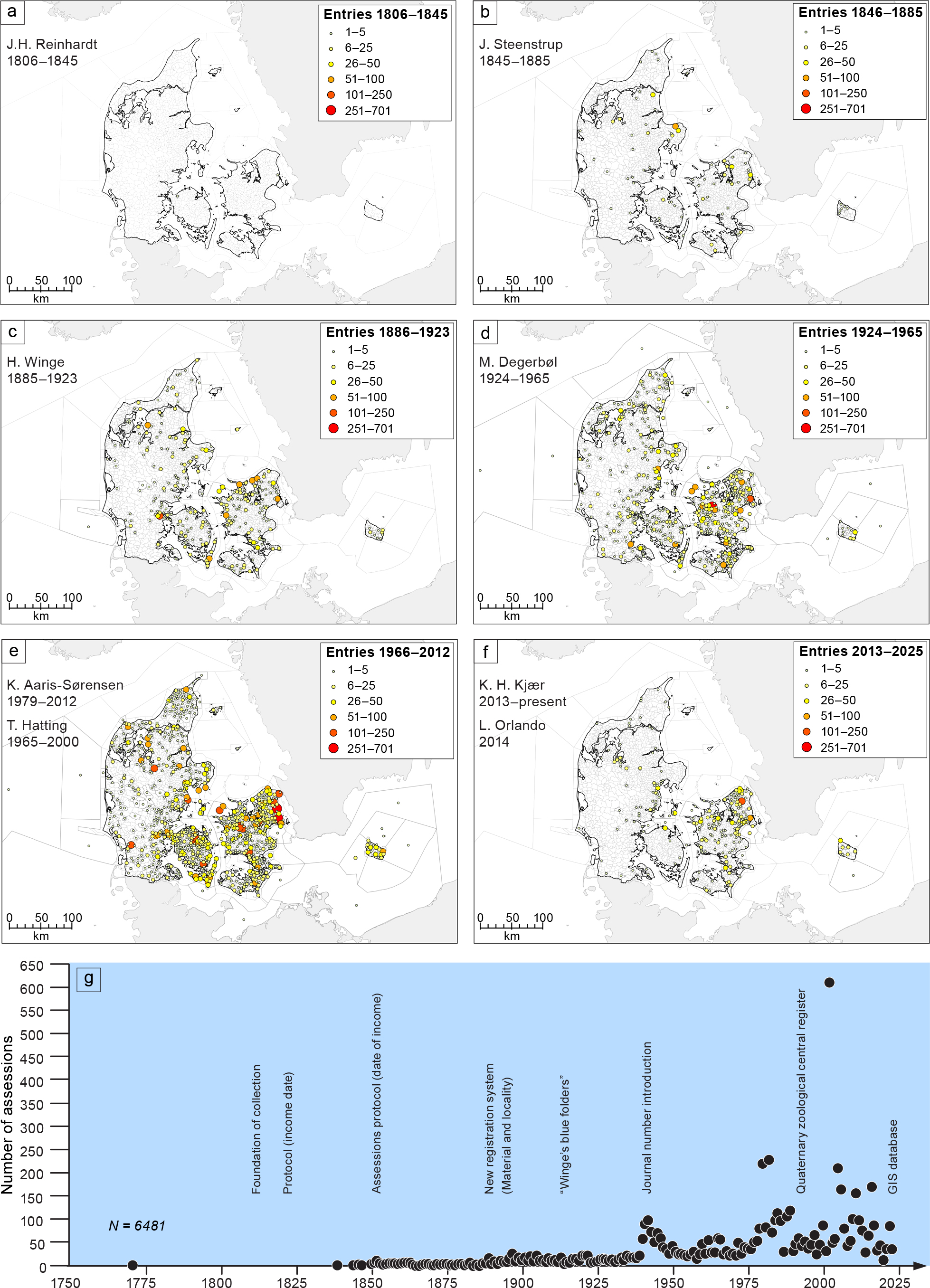
Fig. 1 The temporal and spatial development of the Quaternary zoological collection in Denmark from the early 19th century to the present (N = 6481 entries). Upper panels: geographical distribution of finds during successive curatorial periods. Lower panels: annual accumulation of registrations.
2 Data registration and structure
To document and manage the collection an electronic database system was developed. The DKC was formalised in the 1990s and originally operated using Paradox 4.5 for DOS. The database consists of two linked tables and associated forms and macros (Tables 2 and 3).
| Field Name | Description | ||
| Z.M.K. (Key Field) | Zoological Museum’s Quaternary Zoological Collection journal number. | ||
| Sort.nr. | Sorting number based on Z.M.K. number, formatted as: Year-Three-digit sequence (e.g. 7/1946 becomes 1946-007). | ||
| Fremmed nr. | External journal numbers from other museums. Includes a two-three letter institution code and the journal number. | ||
| Lokalitet | Location, using the parish division before April 1, 1970, as in Trap: Denmark (1953–1972). | ||
| Sogn | Parish | ||
| Herred | District | ||
| Amt | County | ||
| UTM | UTM coordinates (Z, E, N) | ||
| Opbevares | Physical storage location | ||
| Indkommet | Date of entry or registration | ||
| Udgravet | Excavation year(s) | ||
| Fundforhold | Description of find context: A – Archaeological, M – Field or bog (non-archaeological context/geological sediments) | ||
| Datering | Dating method: A: Archaeological-cultural. G: Geological-stratigraphic. P: Pollen analysis. C: C-14 dating | ||
| Kronozone | Chronozone classification based on Mangerud et al. (1974) | ||
| Diverse | Miscellaneous, including publication status, photographs, replicas, and project associations | ||
| Z.M.K.: Zoological Museum Copenhagen. | |||
The DKCFUND table (Table 2) contains contextual and administrative metadata for each registered lot. Key fields are in Danish and include Z.M.K. (journal number), Sort.nr. (year and running number), Fremmed nr. (external journal numbers), Lokalitet (locality), Sogn (Parish), Herred (District), Amt (county) and UTM coordinates, Opbevares (storage location), Indkommet (registration date), Udgravet (excavation year(s)), Fundforhold (archaeological or non-archaeological context), Datering (dating method), Kronozone (chronozone classification following Mangerud et al. 1974), and Diverse (miscellaneous information).
The DKCART table (Table 3) contains taxonomic identifications linked to each find via the Z.M.K. key field. It includes fields for Art (species), Artsnr. (species number), and Bemærkninger (remarks). This relational structure allows separation of contextual metadata from taxonomic data and supports multi-table queries. Importantly, the data set preserves historical catalogue terminology and therefore requires further taxonomic standardisation before analytical use.
The Holocene subdivisions and their approximate age before present (BP) according to Mangerud et al. (1974) and the current International Commission on Stratigraphy (ICS) are compared in Table 4.
| Chronozones (Mangerud et al. 1974) | Subdivision | Climatic and biostratigraphic subdivision of the Holocene epoch | Formal Subdivision of the Holocene series/epoch (IUGS) | Aligned Approx. Age (yrs BP) | |
| Subatlantic | Late | Subatlantic | Meghalayan | 2000–presenta | |
| Subatlantic | Middle | Subatlantic | Meghalayan | 2500–2000 | |
| Subatlantic | Early | Subatlantic | Meghalayan | 3000–2500 | |
| Subboreal | Late | Subboreal | Meghalayan | 4200–3000 | |
| Subboreal | Middle | Subboreal | Meghalayan | 5000–4200 | |
| Subboreal | Early | Subboreal | Meghalayan | 5700–5000 | |
| Atlantic | Late | Atlantic | Northgrippian | 7000–5700 | |
| Atlantic | Middle | Atlantic | Northgrippian | 7600–7000 | |
| Atlantic | Early | Atlantic | Northgrippian | 8200–7600 | |
| Boreal | Late | Boreal | Greenlandian | 9200–8200 | |
| Boreal | Early | Boreal | Greenlandian | 9700–9200 | |
| Preboreal | Late | Preboreal | Greenlandian | 10 200–9700 | |
| Preboreal | Early | Preboreal | Greenlandian | 11 700–10 200 | |
| Younger Dryas | Late Weichselian | Late Weichselian | 12 900–11 700 | ||
| Bølling-Allerød | Late Weichselian | Late Weichselian | 14 700–12 900 | ||
| Oldest Dryas | Late Weichselian | Late Weichselian | 17 000–14 700 | ||
| a: present refers to 2026. Based on Table 5 from Mangerud et al. (1974), proposing finer chronozone subdivisions. Blytt-Sernander classification is refined by Mangerud et al. (1974) and Walker et al. (2018, 2019). BP: Before present. IUGS: International Union of Geological Sciences. | |||||
3 Data processing
To improve accessibility and interoperability, the original DKC database was extracted to Excel, processed and cleaned, and linked to spatial data in ArcGIS Pro (ESRI n.d.) and QGIS (QGIS n.d.) software. As of 1 September 2025, the processed data set contained 20 315 individual entries, of which 19 607 (96.5%) contained spatial information.
Spatial referencing is based on parish (Sogn), district (Herred), and county (Amt), following the parish-municipality divisions pre-01 April 1970, which provide each of these three levels with a unique place number (in Danish Stednummer; Stednummerfortegnelse 1961). These differ from the church parishes (in Danish kirkesogne), and thus from here on ‘parish’ refers to the parish-municipalities. Parish centroid coordinates were extracted in ETRS89/UTM Zone 32N (EPSG:25832) and linked to database entries using Excel’s XLOOKUP function. The use of parish ensures that any samples excavated, also those prior to the use of modern geodetic instruments, could systematically be provided with a spatial location or at least an estimate of the origin. As a measure of uncertainty associated with each find location – the centroid of a given parish – the maximum distance from the centroid to the edge of the specific parish is provide in the column ‘MaxDist’. Standardised naming conventions for localities and museum acronyms ensure consistency across decades of data entry that were preserved during GIS migration. The same applies if individual addresses or geographic coordinates are provided in the original database.
As a quality control measure the location for each entry was assessed and spellings, for example, for parish, district and county names were corrected or streamlined. Where these details were missing entirely, but other spatial information allowed identification of the location, for example, a placename or address, then these details were added. In the absence of specific locality data, these records have been assigned to the Natural History Museum Denmark, more specifically to the former ZM (University of Copenhagen, Denmark), which serves as the reference location in the data set. For easier identification of these entries, they are marked by ‘Yes’ in the column ‘Home_Coord’, while ‘No’ indicates that the parish location is known. Unknown find locations (i.e. ‘Yes’ in the ‘Home_Coord’ column) comprised 3.5% of the entries in the database at the time of publication.
An example of a possible output resulting from the GIS migration is shown in Fig. 2. The relatively large proportion of entries clustered in central Copenhagen, eastern Denmark, reflects specimens for which precise geographical information was not available at the time of registration. The maps demonstrate both the nationwide coverage of the data set and regional clustering, particularly in eastern Denmark, reflecting excavation intensity and preservation potential of bone material.
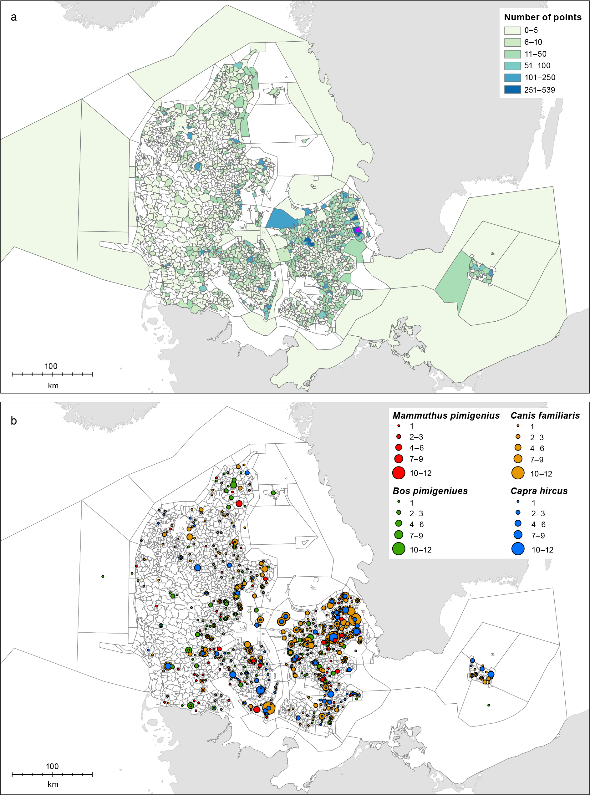
Fig. 2 Spatial distribution of the Quaternary zoological dataset across Denmark. The upper panel shows the total number of registered entries aggregated by parish, displayed as graduated colours representing cumulative counts per parish (ETRS89 / UTM Zone 32N). Darker shades indicate higher concentrations of finds. Purple triangle mark the Zoological museum and depository for the Quaternary zoological collection. The lower four panels present the spatial distribution of selected major taxa groups (e.g. Bos primigenius (aurochs); Canis familiaris (domestic dog); Capra hircus (domestic goat); Mammuthus primigenius (woolly mammoth), with proportional red circles illustrating the number of records per locality.
The administrative boundaries for Danish archaeological museums cover land and coastal waters – the latter are associated with The Viking Ship Museum (Vikingeskibsmuseet) in the east and Marinarkæologi Vest (MAV) in the west (Fig. 3). For more information on the museums, the user is referred to the Agency for Culture and Palaces website (Slots- og Kulturstyrelsen 2026). In addition to the nationwide online data, we have provided subsets according to each of the administrative boundaries within the database.
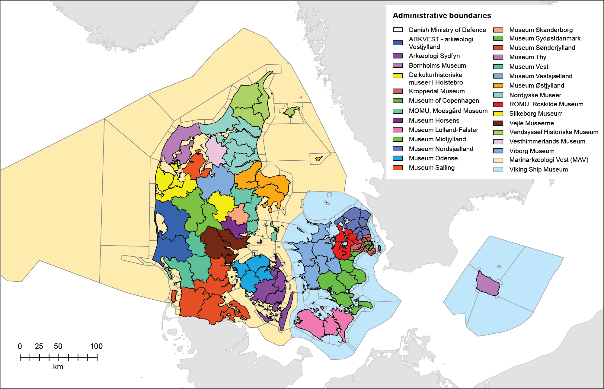
Fig. 3 Administrative boundaries for Danish archaeological museums, including domains covering coastal waters.
4 Dedication to Knud Rosenlund (1946–2024)
This catalogue is dedicated to the memory of Knud Rosenlund (08 March 1946–25 January 2024), whose life and work are inseparably interwoven with the history of the Quaternary Zoological Collections and the DKC. Knud’s generosity, intellectual sharpness, and distinctive sense of humour left an enduring mark on colleagues and collaborators alike. Through six decades of dedicated service, he contributed not only to the growth and reputation of the collections, but to the collegial spirit that sustains scholarly work.
Acknowledgements
The authors would like to thank Nils A. Thomasen for assistance with cleaning the GIS migration data. They also thank the two reviewers, Youri van den Hurk and Sofie Folsach Hellerøe, whose comments improved the manuscript.
Additional information
Authors’ contributions
Kurt H. Kjær initiated the study and Kristian K. Kjeldsen designed the GIS migration. All authors contributed to writing, review & editing (critical review of the manuscript; refinement of language and structure; substantive feedback on interpretations; review and input on figures, tables and supplementary materials). All authors approved the final manuscript.
Additional files
The entire data set including a readme-file are available at: https://doi.org/10.22008/FK2/B7GOPK