 |
DATA ARTICLE SHORT  |
An inventory of landslide events at the Møns Klint UNESCO World Heritage site, Denmark
Kristian Svennevig1*  , Samuel Paul Jackson1 , Marie Keiding1 , Jørgen Bojesen-Koefoed1 , Kurt Kjær2 , Jane Skov Lind3
Abstract
We present a point-based inventory of landslide events at Møns Klint, Denmark. It is compiled from a Danish Nature Agency (Naturstyrelsen) event list, quality-controlled by adding sources where possible and georeferenced from the listed place names to derive best-estimate cliff localities representing potential source areas. The dataset is provided as a GeoPackage and an Excel file containing metadata on date/temporal precision, location, event type, size class and source. The inventory contains 63 events, spanning from 1801 to 2024. Limitations include locality name uncertainty, variable temporal precision, uncertainty in landslide size and type, and reporting bias related to spatial accessibility and uneven documentation through time. The inventory suggests that landslides are relatively evenly distributed across the cliff. They occur throughout the year but cluster in winter and spring. The inventory provides a baseline for operational monitoring and hazard communication at Møns Klint and supports further research on event frequency, spatial distribution and links between landsliding and potential drivers such as coastal erosion, hydro-meteorological forcing and freeze–thaw processes. The dataset may also serve as a template for developing a national landslide-event inventory for Denmark.
Tabular abstract:
| Geographical coverage | Møns Klint, island of Møn, Denmark (approx. 54.94–55.01°N, 12.53–12.56°E). Events stored as point locations along the coastal cliff, spatial resolution depends on locality-name precision. |
| Temporal coverage | Historical record (1801–2024; older events included where year is available). Temporal resolution ranges from exact date to month/season or year. |
| Subject(s) | Geohazards; Quaternary geology; Coastal processes |
| Data format(s) | Analysed/compiled event inventory in GIS format (GeoPackage file) with an attribute table plus an Excel table identical to the attribute table. Data are available for download at https://doi.org/10.22008/FK2/GMYL1L |
| Sample collection and analysis | Compilation from literature and agency records; georeferenced from place names; critical source review and quality control of timing and metadata. |
| Parameters | Event locality; year/date; month/season; qualitative size description; size category; source reference; notes/quality-control comments. |
| Related publications | Kjær et al. in press: Møns Klint, Denmark: A glaciotectonic complex of global significance. GEUS Bulletin 64, 8428. https://doi.org/10.34194/bvng2t84 |
| Potential application(s) for these data | Baseline for monitoring and hazard communication; documentation for site management; integration into national landslide-event inventory; exploratory assessment of spatial clustering and seasonality. |
Citation: Svennevig et al. 2026: GEUS Bulletin 62. 8429. https://doi.org/10.34194/mcz0ak77
Copyright: GEUS Bulletin (eISSN: 2597-2154) is an open access, peer-reviewed journal published by the Geological Survey of Denmark and Greenland (GEUS). This article is distributed under a CC-BY 4.0 licence, permitting free redistribution, and reproduction for any purpose, even commercial, provided proper citation of the original work. Author(s) retain copyright.
Received: 20 Mar 2026; Re-submitted: 08 Jun 2026; Accepted: 09 Jun 2026; Published: 04 Sep 2026
Competing interests and funding: The authors declare no competing interests.
The quality control and write-up of this paper are supported by a 2025–2028 strategic research grant from the Danish Government (Forskningsreserven).
*Correspondence: ksv@geus.dk
Keywords: groundwater chemistry, dissolved inorganic carbon, PHREEQC, freshwater carbonate system
Abbreviations:
DEM: digital elevation model
DTM: digital terrain model
GEUS: Geological Survey of Denmark and Greenland
GIS: Geographical Information System
Edited by: Thomas Find Kokfelt (GEUS, Denmark)
Reviewed by: Aart Kroon (University of Copenhagen, Denmark) and two anonymous reviewers.
1 Introduction
Landslides are potentially dangerous phenomena, which may cause economic damage and loss of life (Petley 2012). At the same time, landslides are important geomorphic processes that contribute to maintaining active coastal cliffs by continually renewing and reshaping slope morphology (Lee 2008). These contrasting aspects are well reflected at Møns Klint in southern Denmark, an iconic coastal cliff that reaches heights of up to approximately 120 m and was inscribed on the UNESCO World Heritage List in July 2025 (Fig. 1).
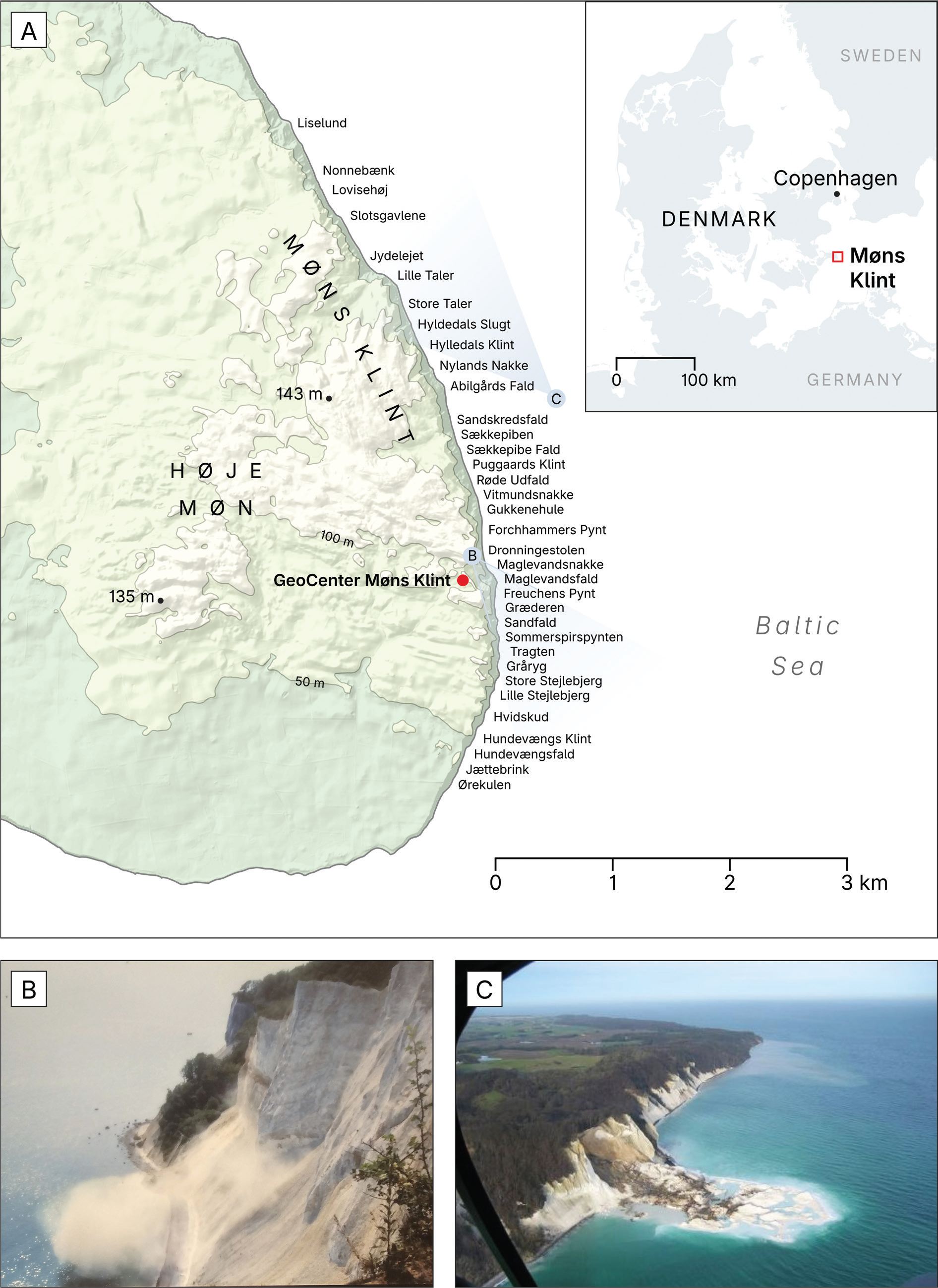
Fig. 1 Overview of the study area. A: Locality map of Høje Møn and Møns Klint showing the distribution of place names available for georeferencing. (B, C) Two famous landslides from Møns Klint demonstrate the range of types of landslides. B: The minor 1994 landslide that killed one person, the first known casualty of landslide activity in Denmark. C: The major 2007 landslide at Store Taler created a 300 m long peninsula into the Baltic Sea. Photos courtesy of Geocenter Møns Klint. The approximate perspectives of the photographs are indicated on the map (light grey shading).
At Møns Klint, landslides are probably among the dominant processes driving cliff retreat and sustaining the spectacular, highly dynamic relief. However, the site is also associated with one of the most consequential landslide events in Denmark when, in 1994, a relatively small landslide (by Møns Klint standards) caused the first known landslide fatality in the country (Fig. 1B; Pedersen 1994). This event illustrates that landslides at Møns Klint represent not only an important and highly dynamic geomorphic agent but also a geohazard with direct societal relevance.
Despite the prominence of the site and the documented impacts of individual events, relatively few studies have focused quantitatively on landslides at Møns Klint, and no formal landslide inventory has previously been published. Existing work includes early documentation of a major landslide at Liselund on north-east Møn in 1905, in which approximately 40 000 m² of an estate park reportedly disappeared within minutes (Hintze 1920). Hintze (1937) later compiled a list of several historical landslides from Møns Klint. Scientific interest increased after the fatal 1994 event (Pedersen 1994; Busby et al. 2002; Hutchinson 2002; Pedersen & Møller 2004). Subsequently, a major landslide at Store Taler in January 2007 was described by Pedersen (2007) and Pedersen & Gravesen (2009). That event produced a peninsula extending approximately 300 m into the sea, which has since been fully eroded by waves, illustrating the rapid reworking of landslide deposits on this coast (Fig. 1).
A national landslide inventory for Denmark exists, in which landslides are mapped as polygons based on morphological signatures identified in a nationwide 0.4 m LiDAR digital terrain model (DTM; Svennevig et al. 2020; Luetzenburg et al. 2022). Landslides at Møns Klint are underrepresented in such an approach because deposits and diagnostic morphology can be rapidly erased by continued coastal erosion and reworking, limiting their persistence in topographic datasets.
With the new UNESCO World Heritage designation and the future opening of the Femern Bælt link to Germany, visitor numbers at the foot of the cliff are expected to increase, and thus the exposure of people to landslide hazard is likely to grow. For this reason, it is increasingly important to improve documentation of where and when landslides occur at Møns Klint and to provide a robust baseline for future work on dynamic and static preconditioning factors and hazard management.
In this study, we present an inventory of landslide events for Møns Klint, describe how it was compiled and quality-controlled and summarise the principal characteristics and limitations of the data set. The inventory is intended as the basis for an ongoing effort to register landslides at Møns Klint and will, in future, be maintained by the Geological Survey of Denmark and Greenland (GEUS) with input from local stakeholders.
1.1 Geological setting and physiography
Møns Klint forms the coastal cliff exposure of the Høje Møn glaciotectonic complex, where glaciotectonically deformed chalk and Quaternary sediments are exposed along a 6 km long coastline. The cliff reaches heights of up to c. 120 m and is backed by the hilly terrain of Høje Møn, which rises to 143 m above sea level.
Recently, a combined glaciotectonic and landform model has been proposed to explain the structural evolution of Møns Klint (Kjær et al. 2026). The model integrates geomorphological observations from ridge orientations with stratigraphic evidence from the coastal cliffs. It suggests that the glaciotectonic architecture developed through several ice-push phases rather than a single glacial event – a hypothesis previously also put forward by Pedersen (2000). Initial thrusting and structural organisation likely began during the Middle Weichselian ice advances. Later glacial advances during the Late Weichselian reactivated and amplified the earlier structures. This produced a complex fold-and-thrust system in which chalk sheets were stacked and displaced over one another. The resulting deformation created the prominent ridge-and-hollow landscape of eastern Møn. Stratigraphic relationships within the cliff exposures provide key constraints on the timing and sequence of deformation. The model therefore reconciles geomorphological landforms with the structural geology of the cliff sections. It highlights the importance of polyphase deformation (i.e. deformed by multiple glacial advances from different directions) and structural inheritance in shaping the present landscape. Consequently, the architecture of Møns Klint reflects repeated glacier-sediment interactions over multiple glacial phases.
The steep relief, material properties and glaciotectonic architecture of the exposed units, along with continuous coastal erosion at the cliff toe, create favourable conditions for repeated landslides.
2 Data collection and main features of the new landslide inventory for Møns Klint
2.1 Source material and compilation strategy
The inventory is a compilation of reported landslide events at Møns Klint based on historical and modern sources. The starting point was a draft list assembled by the Danish Nature Agency (Naturstyrelsen), drawing on documented events in Hintze (1937), cases discussed by Hutchinson (2002) and additional unpublished information derived from internal records, archives and local knowledge. Building on this foundation, we have updated and quality-controlled the data set through review of publications, news items and technical reports in which specific events are described.
2.2 Quality control and standardisation
Where possible, original publications and reports were revisited to confirm event timing, locality and qualitative descriptions. Timing fields were standardised so that exact dates were recorded where available, while month or season information was retained where only partial temporal information exists. Locality spelling variations were harmonised to enable consistent Geographical Information System (GIS) representation. Size category assignments were applied consistently across the data set using the criteria described later. Records were checked for uniqueness of identifiers, completeness of essential fields and basic attribute integrity.
2.3 Inventory structure and attribute fields
The inventory is provided as a GIS GeoPackage (EPSG:25832; Møn_Landslide_Inventory.gpkg) containing point geometries and an accompanying attribute table (Møn_Landslide_Inventory.xlsx). It contains 63 entries (rows) and up to 11 attributes (columns) per entry. Each record contains a unique event identifier and descriptive fields intended to retain both timing information and provenance. Core fields include locality name, year, date (where known), time of year (month where known, otherwise season), qualitative size description, assigned size category, source reference and compilation notes.
2.4 Spatial representation and georeferencing
A map of the inventory shows that recorded landslides of various sizes occur along the full length of the cliff (Fig. 2). The location of the landslides is associated with some uncertainty. A key challenge is that scars and deposits often have limited persistence due to rapid coastal erosion and reworking. For example, the major landslide at Store Taler in 2007 is said to have produced a 300 m-long peninsula that persisted for 3 years. Therefore, none of the events are mappable as polygons in modern terrain models, in contrast to the national landslide inventory that is derived from morphological mapping of landslides based on the 0.4 m national LiDAR-DTM (Svennevig et al. 2020; Luetzenburg et al. 2022).
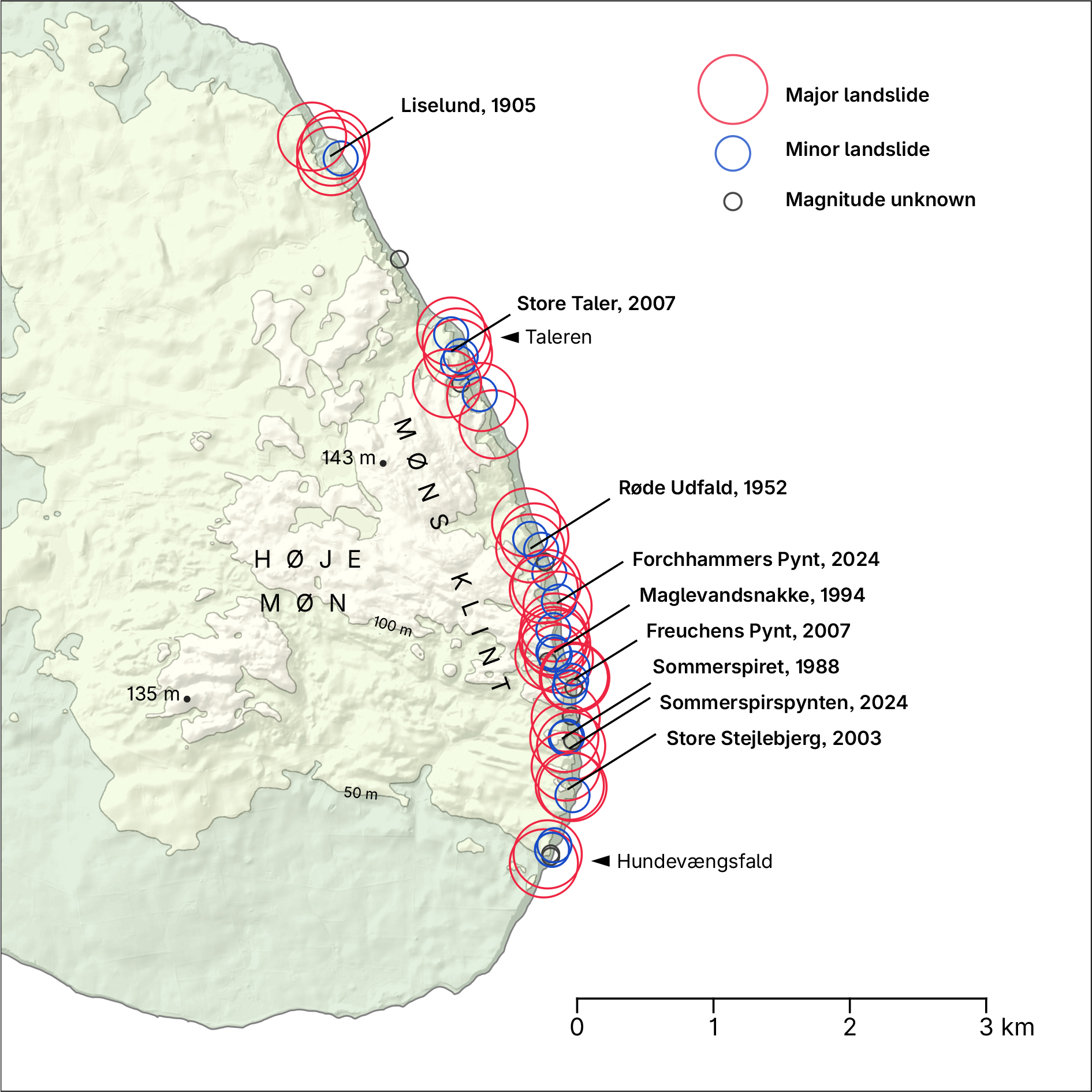
Fig. 2 Spatial distribution of landslide events at Møns Klint. Some of the more famous landslides are labelled. The map shows that landslides are distributed throughout the cliff from Taleren to Hundevængsfald. For a complete overview of events and their locality, we refer to the GeoPackage file (Møn_Landslide_Inventory.gpkg) in the database.
For this reason, and because all entries are given with a locality name, landslide events at Møns Klint are stored as a point data set. Events are georeferenced based on reported locality names along the cliff. Each point represents an approximate location intended to correspond to the likely source area in the relevant cliff section rather than the full landslide extent. This representation is appropriate for an event inventory intended primarily to document occurrence and timing and to support analysis of broad spatial patterns.
The use of locality names to georeference the landslides introduces spatial uncertainty and a form of reporting bias. Place names are not distributed uniformly along Møns Klint, and in some sections, a single locality name may cover a long distance. This is, for example, the case for Sandskredsfald, which is the only place name for 600 m in the central part of the cliff (Fig. 1A). Consequently, multiple events tend to be assigned to the same approximate point location, whilst neighbouring, unnamed cliff segments can appear artificially sparse. Spatial patterns in the data set are therefore most appropriately interpreted as reporting density by locality reference rather than as a complete representation of physical landslide density. Future entries into the database should be based on geographical coordinates rather than place names.
2.5 Qualitative size information
Magnitude information in the inventory is qualitative. Quantitative estimates of landslide area or volume are not available, as no landslides at Møns Klint have been studied in detail. To facilitate basic comparisons, events are classified into two broad categories – ‘minor’ and ‘major’ – based on the qualitative descriptions available in the sources. Events are assigned ‘unknown’ if it is not possible to assign them a category in this way. In general, ‘major’ landslides produce a peninsula that survives erosion for a relatively long time (i.e. more than 6 months), whereas ‘minor’ landslides produce only short-lived, small incursions into the sea or are expressed as piles of fallen boulders at the foot of the cliff. The 2007 landslide is a good example of a ‘major’ landslide with a long runout, whereas the fatal landslide in 1994 is an example of a ‘minor’ landslide. Following the landslide classification of Hungr et al. (2014), these would probably be classified as chalk flow or rock avalanche and rockfall, but further studies are needed to establish this with more certainty.
2.6 Bias in the timing of events
Many modern events are reported with exact dates, whereas older entries may provide only the year or general season, but dates for the timing of landslides are usually reported rather precisely (Fig. 3). There may be a bias towards smaller events being reported more often in the summertime than in the wintertime due to more people visiting the cliff here and experiencing the smaller landslides. Larger (major) landslides are, however, expected to be reported throughout the year, as the deposits from these are persistent for several months to years and thus easily observable by visitors and forest rangers from The Danish Nature Agency.
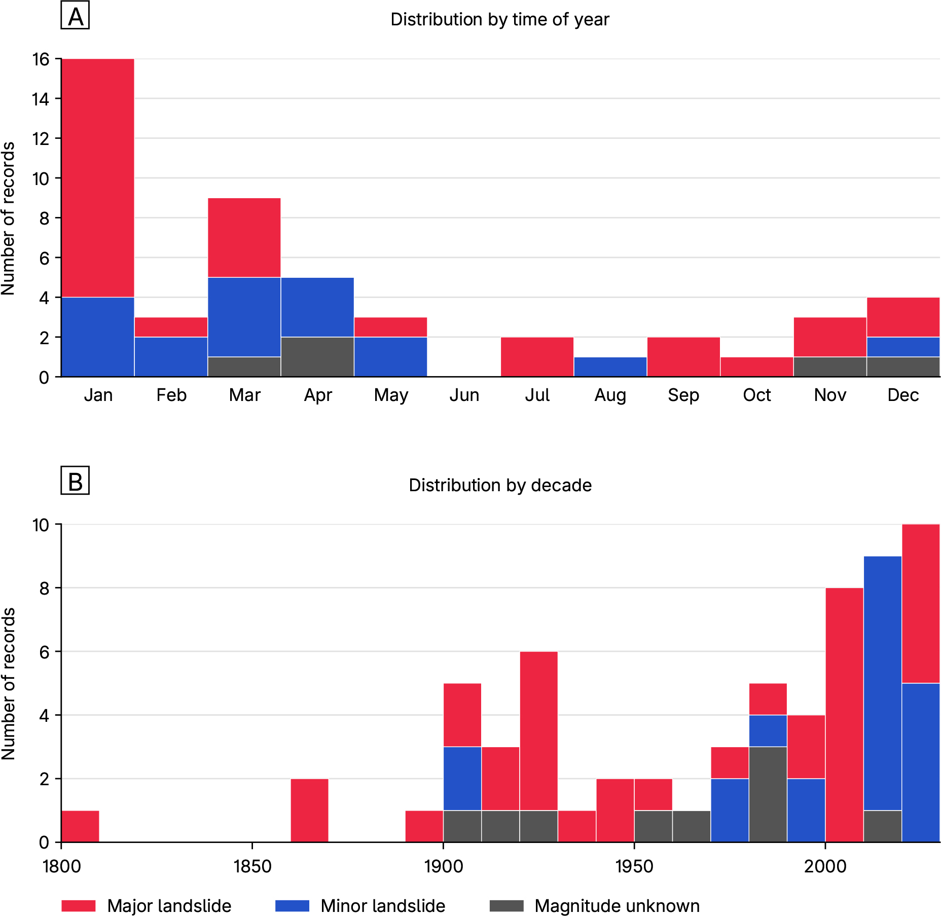
Fig. 3 Temporal patterns in the landslide inventory. A: Distribution throughout the year showing clustering in winter and spring. B: Occurrence of recorded events over time. The distribution probably mostly reflects sample bias towards more events recorded in more recent times.
The temporal distribution of recorded landslides throughout the past centuries (Fig. 3B) probably primarily reflects a sampling bias towards larger and more recent events, rather than a clear increase in landslide frequency over time. This is due to the sources available and a possible increase in visitors over this period.
2.7 Temporal patterns and potential triggering factors
The data set enables a qualitative assessment of when events are recorded throughout the year. Landslides are documented in all seasons but are more frequent in late winter and early spring. This period coincides with generally high groundwater levels in Denmark relative to the summer season and with increased landslide activity reported in other Danish settings (Svennevig et al. 2024). At Møns Klint, a number of other triggering factors have also been proposed: Hutchinson (2002) studied several chalk cliff sections in Northern Europe, one of them being Møns Klint. He suggested that chalk flows initiating as a fall are triggered when the chalk is saturated or near saturated. Pedersen & Møller (2004) suggest that a landslide on 5 July 2003 at Store Stejlebjerg was triggered by a very dry spring followed by heavy rainfall immediately preceding the cliff collapse. Nadim et al. (2008) briefly discuss chalk cliff collapse in Denmark (including Møns Klint) and mention that landslides often occur in the late winter to early spring, when groundwater saturation is highest, and freeze–thaw action triggers the rock falls, but they provide no reference for these observations.
The new landslide event inventory does not quantify drivers directly, but it provides a framework for linking future event documentation to climatic forcing data. Several mechanisms may plausibly contribute to failure at Møns Klint, acting individually or in combination over different timescales, including:
- Coastal undercutting and storm surges, which promote toe erosion and local over-steepening.
- Prolonged or intense precipitation, increasing pore-water pressures and reducing effective stress.
- Elevated groundwater levels, including seasonal and event-driven rises that can precondition failure.
- Freezing and thawing, including frost-induced weakening and frozen pore water locally impeding groundwater flow.
This can be exemplified in the winter of 2023–2024 where three relatively large (here classified as major) landslides occurred at Møns Klint within a short time interval in January of 2024. The events were preceded by the storm Babet in October 2023 (Groll et al. 2025). The nearest tide gauge to Møns Klint, 60 km to the south-west at Gedser, with continuous records since 1892, reached +189 cm above the mean water level, the highest ever recorded there (DMI 2023). This was followed by persistently high groundwater conditions during the winter and frost conditions in the days before failure. This is along the same lines as the preconditioning proposed by Nadim et al. (2008).
These processes do not, however, explain the relatively rare landslides that happen during summer, when groundwater levels are usually low, storms are rare and there is an absence of freeze-thaw processes. The summer period is when most visitors are on the beach, and thus, the exposure to landslide hazard is highest, making these rare events important to study as well (Pedersen & Møller 2004).
Ultimately, detailed studies of individual landslide events are needed to help quantify what preconditions them. Disentangling the relative importance of triggers will require targeted monitoring and event-based documentation. Priorities include groundwater level and pore-pressure measurements in the cliff, wave-climate and toe erosion monitoring and repeat topographic-change detection (e.g. Digital elevation model, DEM, differencing) to quantify pre- and post-failure morphology.
2.8 Outlook and pathways for data set improvements
While the inventory is dominated by qualitative size information and locality-name georeferencing, it provides a structured baseline for continued documentation and future quantification.
It is possible, at least in part, to quantify some of the events back in time. For approximately the past 80 years, aerial imagery may offer opportunities to reconstruct selected events and estimate approximate scar extents. Higher-frequency satellite imagery, mainly since the advance of the Sentinel-2 (2015) and Planet (2016) constellations, can support event detection and timing constraints for major failures. Future work may extend the data set by adding landslide-type classifications (sensu Hungr et al. 2014) where descriptions or imagery allows, and by quantifying pre- and post-event elevation models, morphological mapping and runout analysis of future events. These approaches could also be applied to a small set of major historical events (e.g. 1952 and 2007) where detailed photos may be obtained for analysis to better constrain volumes, runout characteristics and likely failure mechanisms.
The event-inventory approach introduced here is also intended to support development of a national landslide-event inventory for Denmark: a point database of landslide-related events (for example, observed fracture opening, toe uplift or individual long-runout landslides) that supplements the national landslide inventory (Svennevig et al. 2020; Luetzenburg et al. 2022). At Møns Klint and other Danish chalk cliffs such as Stevns Klint, an event typically corresponds to a discrete cliff failure with a recognisable (albeit often quickly erodible) deposit (Pedersen & Damholt 2012). In many other Danish settings dominated by glacial deposits, landslides are slow-moving, long-lived morphological features with dormant periods, and landsliding is expressed as episodes of enhanced movement affecting parts of, or entire, landslides. Such episodes may manifest as fracture opening, toe uplift or damage to infrastructure. These processes are not readily captured in the national landslide inventory, which maps the morphological entity that is the landslide, but are better suited to a national landslide-event inventory.
Monitoring of landslides at Møns Klint may also be supported by a local seismic network installed in February 2025 and planned for operation until the end of 2027, which can provide an independent record of failure activity during this period. Comparable seismic monitoring approaches have been used for coastal cliff-failure detection elsewhere (e.g. at Rügen, Dietze et al. 2020), supporting the feasibility of developing event catalogues from the Møns Klint seismic network. Furthermore, wave run-up measurement can be quantified via e.g. video to estimate coastal erosion potential and the coupling to landslide preconditioning (Harley & Kinsela 2022).
Acknowledgements
We thank retired forest manager (skovfoged) of the Danish Nature Agency (Naturstyrelsen) H.C. Gravesen for initiating the landslide inventory. We also acknowledge colleagues and local stakeholders at Møns Klint, namely, Geocenter Møns Klint, for discussions and input supporting compilation and quality control. Aart Kroon (University of Copenhagen, Denmark) and two anonymous reviewers are thanked for their constructive reviews.
Additional information
Author contributions
KS designed, led the study and wrote the initial manuscript draft. SPJ contributed to data set structuring, figure drafting, GIS processing and manuscript revision. MK contributed to the compilation and review of source material. JBK contributed to quality control and georeferencing of the database. KK and JSL contributed to review and editing.
AI Declaration
AI-assisted tools, specifically ChatGPT (GPT-5 Thinking) and Grammarly (free version), were used during the writing for proofreading and minor language edits (grammar, structure, clarity and style). These tools were not used to generate scientific content, results, interpretations or references.
Additional files
The data, in the form of a geopackage file (Møn_Landslide_Inventory.gpkg) and an Excel file (Møn_Landslide_Inventory.xlsx), are available for download at https://doi.org/10.22008/FK2/GMYL1L