 |
RESEARCH ARTICLE  |
Lithostratigraphy of the Portfjeld Group (Ediacaran – lowermost Cambrian) of North Greenland
Abstract
The Portfjeld Formation, as originally defined, is the lowermost lithostratigraphic unit of the mainly Lower Palaeozoic Franklinian Basin in southern Peary Land, central North Greenland. The unit crops out semi-continuously from Valdemar Glückstadt Land to Nordenskiöld Fjord but is also recognised locally in northern parts of Peary Land and Wulff Land (western North Greenland). Regionally, it provides a key record of the early, pre-break-up history of the basin. The type succession in southern Peary Land has thus been the focus of recent biostratigraphical, sedimentological and geochemical study. This has demonstrated the composite nature of the unit, a lower interval (c. 190 m thick) of carbonate ramp deposits of Neoproterozoic (late Ediacaran) age being overlain at a karstic unconformity by a shallow marine, mixed carbonate–siliciclastic interval (c. 100 m thick) of probable earliest Cambrian age. Lithostratigraphic revision of this succession is presented here. The Portfjeld Formation throughout North Greenland is elevated to the rank of group, and two new formations are defined in this group in southern Peary Land and immediately adjacent areas: the Ediacaran carbonate-dominated unit is referred to the Slusen Formation, the upper mixed siliciclastic–carbonate unit to the Glaciologelv Formation.
Citation: Ineson et al. 2024: GEUS Bulletin 57. 8375. https://doi.org/10.34194/geusb.v57.8375
Copyright: GEUS Bulletin (eISSN: 2597-2154) is an open access, peer-reviewed journal published by the Geological Survey of Denmark and Greenland (GEUS). This article is distributed under a CC-BY 4.0 licence, permitting free redistribution, and reproduction for any purpose, even commercial, provided proper citation of the original work. Author(s) retain copyright.
Received: 07 May 2024; Revised: 03 July 2024; Accepted: 27 August 2024; Published: 11 October 2024
Competing interests and funding: The authors declare no competing interests.
Funding for fieldwork in 2006 was supported by the Danish Natural Science Research Council (FNU Jr. nr. 272-05-0293).
*Correspondence: [email protected]
Keywords: Neoproterozoic, Slusen Formation, Glaciologelv Formation, carbonate ramp, karst
Abbreviations:
BACE: BAsal Cambrian Excursion
Edited by: Karen Dybkjær (GEUS, Denmark)
Reviewed by: Paul Smith (Oxford University Museum of Natural History, UK), Keith Dewing (Natural Resources Canada, Canada)
1. Introduction
The basal sedimentary strata of the Franklinian Basin in southern Peary Land and adjacent areas of North Greenland (Figs 1, 2) were defined formally as the Portfjeld Formation by Jepsen (1971; see also O’Connor 1979; Higgins et al. 1991a; Ineson & Peel 1997). This formation comprises a heterogeneous succession up to 300 m thick that is dominated by dolostones but includes prominent siliciclastic units and minor limestone intervals. Strata referred to this formation are also recognised in north-eastern Peary Land and northern parts of central and western North Greenland (Christie & Ineson 1979; Peel 1982; Higgins & Soper 1985; Surlyk & Ineson 1987; Higgins et al. 1991a; Ineson & Peel 1997), and inferred correlatives (referred to the Ella Bay Formation) crop out on Ellesmere Island, Nunavut, Arctic Canada (Long 1989; Dewing et al. 2004). The Portfjeld Formation was previously ascribed a probable early Cambrian age, based on limited fossil evidence (Peel 1988) and correlation to Canada where lower Cambrian fossils were reported by Long (1989) from the Kennedy Channel Formation that is overlain by the Ella Bay Formation on Judge Daly Peninsula. Subsequent detailed mapping of Ellesmere Island demonstrated that the fossiliferous strata were emplaced tectonically from the Ellesmere Group, which overlies the Ella Bay Formation; a probable Neoproterozoic age was proposed for the Ella Bay Formation and potentially for the correlative Portfjeld Formation in North Greenland (Dewing et al. 2004; Peel & Skovsted 2021).
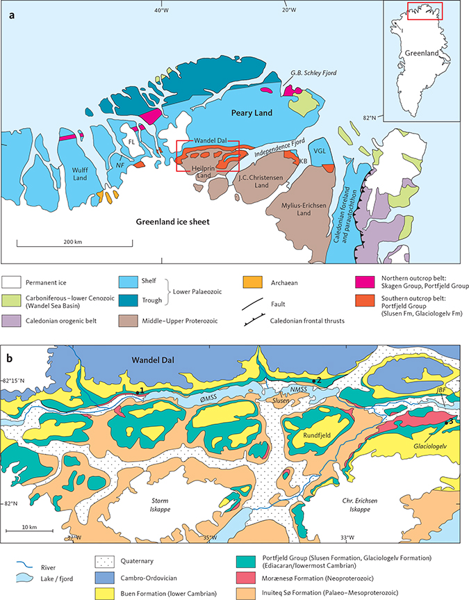
Fig. 1 Geological maps. a: The southern and northern outcrop belts of the Portfjeld Group across North Greenland; inset shows the location of the study area and Inglefield Land (I) in northernmost Greenland. FL: Freuchen Land. KB: Kap Bernhard. NF: Nordenskiöld Fjord. VGL: Valdemar Glückstadt Land. Red box indicates type area (Fig 1b). b: The type area of the Portfjeld Group in southern Peary Land and Heilprin Land; modified from the digital Greenland geological map at a scale of 1:500 000 (Kokfelt et al. 2013). The locations (1–3) of the type and reference sections of the new formations (Slusen Formation, Glaciologelv Formation) are indicated: (1): Type Slusen Formation, reference Glaciologelv Formation. (2): Type Glaciologelv Formation, reference Slusen Formation. (3): Reference Glaciologelv Formation. JBF: Jørgen Brønlund Fjord. NMSS: Nedre Midsommersø. ØMSS: Øvre Midsommersø.
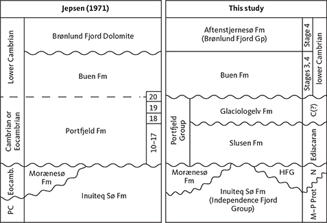
Fig. 2 Lithostratigraphic scheme of the Precambrian – lower Cambrian of southern Peary Land showing the relationship of the revisions presented here to the original definition of Jepsen (1971); the numbers (10–20) refer to the lithological units in the type section described by Jepsen (1971). C(?): Inferred lowermost Cambrian. Eocamb.: Eocambrian. HFG: Hagen Fjord Group. M–P Prot.: Meso – Palaeoproterozoic. N: Neoproterozoic. PC: Precambrian. Fm: formation. Gp: group.
Detailed sedimentological and stratigraphic investigation of the Portfjeld Formation in southern Peary Land in 2006 revealed the composite nature of the formation in this area, a prominent, regionally persistent karstic surface separating a lower carbonate-dominated unit (150–200 m thick) from an upper mixed siliciclastic–carbonate unit (c. 100 m thick; Fig. 3a, b). Preliminary isotopic data suggested a Neoproterozoic age for the lower unit (Ineson et al. 2007). Recent biostratigraphic re-analysis of the lower carbonates revealed a rare but well-preserved micropalaeontological assemblage that includes acritarchs, cyanobacteria, and putative eggs and embryos; in association with the δ13C isotope data, this microbiota confirms a late Ediacaran (latest Neoproterozoic) age (Willman et al. 2020; Rugen et al. 2022). Although unfossiliferous, the upper unit of the Portfjeld Formation shows an isotopic signal that is compatible with an earliest Cambrian age (Willman et al. 2020).
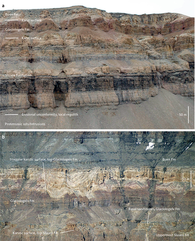
Fig. 3 General views of the Portfjeld Group in southern Peary Land. a: The Portfjeld Group (Slusen and Glaciologelv Formations) on the northern side of Rundfjeld, just south of the eastern end of Nedre Midsommersø, illustrating in particular the well-stratified, banded and cyclic nature of the Slusen Formation; the prominent dark unit in the lower Slusen Formation forms an important marker throughout the southern outcrop belt. b: View of the upper Portfjeld Group on the south side of Øvre Midsommersø showing the two reddened karstic surfaces bounding the Glaciologelv Formation. The internal architecture of the orange fluvial sandstones at the base of the Buen Formation records episodic syndepositional subsidence of the karstic depressions (dolines) at the top of the Portfjeld Group.
Given this clear confirmation of the composite nature of the Portfjeld Formation in southern Peary Land, it is considered inadvisable to retain the definition of Jepsen (1971) both on lithostratigraphic grounds and with a view to a more nuanced understanding of the early evolution of the Franklinian Basin. The aims of this paper, therefore, are first to elevate the Portfjeld Formation, as recognised widely in North Greenland, to the rank of group, and second to define and describe two new formations in the Portfjeld Group in southern Peary Land and immediately adjacent areas (Fig. 2). The detailed stratigraphy of these early Franklinian Basin deposits is of wider significance, however, both in charting patterns of early syn-rift subsidence and subsequent crustal break-up and as they host two palaeobiologically important Lagerstätten – the recently reported Ediacaran biota of the Portfjeld Group (Willman et al. 2020) and the well-documented lower Cambrian Sirius Passet biota in the overlying Buen Formation (Peel 2010; Ineson & Peel 2011; Harper et al. 2019).
2. Regional setting
Northern Greenland formed part of a major east–west-trending extensional basin, the Franklinian Basin, from the latest Proterozoic to the Devonian. This basin extended almost 2000 km across northern Greenland and the Canadian Arctic Islands; the two areas can be correlated closely at many stratigraphic levels (Trettin 1989; Higgins et al. 1991a, b; Trettin et al. 1991; Faehnrich et al. 2023). Two discrete elements characterised the basin – a predominantly marine shelf to the south underlain by Precambrian cratonic basement, passing north into a deep-water basin. The boundary between these two regimes was controlled by major east–west structural lineaments that were variably active during the history of the basin; the boundary shifted southwards with time, following the successive activation of these structures (Surlyk et al. 1980; Higgins et al. 1991a; Surlyk 1991). The basin fill has a total thickness approaching 8 km; the shelf succession is carbonate-dominated, but an important siliciclastic formation is represented in the lower Cambrian. Deep-water basinal facies are largely siliciclastic with discrete intervals of redeposited carbonate, shed from the coeval southern shelf regime. The Franklinian Basin was deformed and uplifted during the Ellesmerian Orogeny in the Late Devonian – Early Carboniferous. Pervasive deformation and metamorphism were restricted to the deep-water basinal deposits in the north, though adjacent outermost shelf strata were involved in thin-skinned tectonics (Fig. 1; Soper & Higgins 1990). The shelf deposits of southern Peary Land, under focus here, are undeformed, dipping gently towards the north.
The extensional nature of the Franklinian Basin, evolving into a passive margin setting in the Cambrian, is well documented (Higgins et al. 1991a; Surlyk 1991; Hopper & Ineson 2021), but the early syn-rift history and the timing of continental break-up remain poorly understood. The Portfjeld Group (as redefined here) is a key element in the early basin record, particularly as it is capped by a regional unconformity that is inferred to represent break-up and the onset of seafloor spreading (Higgins et al. 1991a; Surlyk 1991; Hopper & Ineson 2021).
3. Lithostratigraphy
The lithostratigraphy of the Portfjeld Formation of Jepsen (1971) is formally revised here: the Portfjeld Formation is raised in rank to a group, and two new formations (Slusen Formation, Glaciologelv Formation) are defined in the southern outcrop belt.
3.1 Lithostratigraphic framework of North Greenland
3.1.1 Portfjeld Group
revised unit
History. Defined and mapped as a formation in southern Peary Land by Jepsen (1971) and recognised more widely in North Greenland by Christie & Ineson (1979), O’Connor (1979), Peel (1982) and Higgins & Soper (1985).
Type area. Wandel Dal, southern Peary Land (Fig. 1).
Thickness. In the type area of southern Peary Land, the group is 200–300 m thick, thinning south-eastwards to 50–70 m in eastern J.C. Christensen Land. In the northern outcrop belt, the thickness of the group ranges from 300 to 700 m, thickening northward to the northern limit of the group.
Lithology. The Portfjeld Group is a pale weathering, dolostone-dominated succession with subordinate sand-rich siliciclastic units and minor limestones. In southern Peary Land, the group is well-stratified and banded; a prominent dark stripe dominates exposures along Wandel Dal (Fig. 3a). Varied microbial carbonates typify the type area, including thrombolitic bioherms and biostromes and mesoscopic domal stromatolites. Cyclic grainstone-rich facies characterise certain levels, displaying intraclastic and ooidal fabrics; giant ooids occur at some levels. The grainstones display planar, trough and hummocky cross-stratification. Siliciclastic sandstones occur locally at the base of the group and about 200 m above the base, within and above a prominent brecciated karstic surface. Detailed descriptions and illustrations of the stratigraphic succession of the Portfjeld Group in the type area are provided here under the component formations.
In the northern outcrop belt, the Portfjeld Group is characterised by a thick, uniform succession of pale grey dolostones displaying relict cross-stratified grainstone fabrics. Subordinate microbial carbonates form discrete biostromal units that typically exhibit columnar stromatolites, although complex domal stromatolite patch reefs occur locally near the northern shelf margin, interdigitating with cross-bedded grainstones (Ineson & Peel 2011).
Fauna, flora and age. Although essentially unfossiliferous and lacking an ichnofauna, a rare microbiota has been recovered from the lower Portfjeld Group in southern Peary Land; this includes acritarchs, cyanobacteria, putative eggs, problematic tubular fossils, embryos and red algal thalli (Willman et al. 2020; see Slusen Formation, below). Furthermore, the lower Portfjeld Group in this area exhibits a marked negative carbon isotope excursion (–12‰; Willman et al. 2020; Rugen et al. 2022). The palaeontological and isotopic data together indicate a general late Ediacaran (Neoproterozoic) age for this level of the group in southern Peary Land.
Fossils have not been recovered from the upper Portfjeld Group in southern Peary Land, nor from the entire group in the northern outcrop belt. The group is overlain unconformably by the Buen Formation, which has yielded fossils of early Cambrian age (Stages 3 and 4; Peel & Willman 2018), and the Portfjeld Group regionally is thus assigned a latest Neoproterozoic – earliest Cambrian age.
Depositional environment. The Portfjeld Group records deposition on a carbonate ramp and shallow-water carbonate platform that bordered the embryonic deep-water part of the Franklinian Basin (Higgins et al. 1991a). Details of the depositional facies and setting in the type area of southern Peary Land are provided below under the Slusen and Glaciologelv Formations. In the northern outcrop belt, the Portfjeld Group is dominated by shallow-water, high energy platform facies that accumulated in an outboard, marginal setting at the transition to the deep-water basin (Surlyk & Ineson 1987; Higgins et al. 1991a; Ineson & Peel 1997, 2011).
Boundaries. In southern Peary Land, and to the south-east (Heilprin Land, J.C. Christensen Land), the Portfjeld Group unconformably overlies a range of Precambrian units – the Palaeoproterozoic–Mesoproterozoic Independence Fjord Group or the Neoproterozoic Morænsesø Formation in southern Peary Land and northern Heilprin Land, the Neoproterozoic Hagen Fjord Group in south-east Heilprin Land and northern J.C. Christensen Land. The unconformity is characteristically flat but locally the basal strata onlap an irregular weathered regolith (see Slusen Formation, below). At the eastern end of the northern outcrop belt, the Portfjeld Group unconformably overlies Precambrian sedimentary strata and volcanics, locally with significant relief (Christie & Ineson 1979). Westwards, from north-west Peary Land to northern Wulff Land, the Portfjeld Group overlies with apparent conformity, the Skagen Group (Higgins & Soper 1985; Surlyk & Ineson 1987; Higgins et al. 1991a).
The Portfjeld Group is everywhere overlain unconformably by the lower Cambrian Buen Formation (Fig. 3). In southern Peary Land, along Wandel Dal (Figs 1, 3), the unconformity is planar at a large scale, but highly irregular in detail, ranging from a mesoscale sutured surface to a series of isolated steep-sided depressions (dolines) up to several hundreds of metres across and tens of metres deep, filled with basal fluvial sandstones of the Buen Formation (Fig. 3b). This karstic imprint at the unconformity is widespread, being also in evidence in north-west Peary Land (Ineson & Peel 2011; Smith & Moseley 2022) and central and western North Greenland (Davis & Higgins 1987). At Kap Bernhard, north-east J.C. Christensen Land, in contrast, where the unconformity represents a more significant erosion surface (the upper Portfjeld Group being absent), the unconformity surface is flat and planar (see Slusen Formation, below).
Distribution. The Portfjeld Group crops out in two broad east–west belts (Fig. 1a). The southern outcrop belt extends from the head of Nordenskiöld Fjord, south of Freuchen Land, eastwards to eastern Valdemar Glückstadt Land (Fig. 1a). Excellent, continuous exposures occur on both sides of the valley of Wandel Dal in southern Peary Land. South-west of Nordenskiöld Fjord, the Portfjeld Group is not recognised in situ, but bedded slabs derived from the group form a prominent component of a megabreccia sheet up to 270 m thick that is well-exposed in southern Wulff Land (Hurst & Peel 1979; Peel & Wright 1985; Surlyk & Ineson 1987). The Portfjeld Group is absent in Inglefield Land in North-West Greenland where the Dallas Bugt Formation (equivalent to the Buen Formation) rests directly on Precambrian rocks.
The northern outcrop belt is discontinuous but is traceable from north-east Peary Land to northern Wulff Land within folded and/or faulted terranes, marginal to the North Greenland Fold Belt. The Portfjeld Group crops out in faulted inliers in the east and in the cores of major anticlines in central and western North Greenland.
Subdivision. In southern Peary Land and immediately adjacent areas to the south-east (Heilprin Land, J.C. Chriestensen Land, Valdemar Glückstadt Land), the Portfjeld Group is herein formally subdivided into two formations, the Slusen and Glaciologelv Formations. The Portfjeld Group in the northern outcrop belt is presently undifferentiated; detailed correlation with the southern area and potential formal subdivision necessitate future stratigraphical and geochemical investigations.
3.2 Lithostratigraphy of the Portfjeld Group in southern Peary Land and adjacent areas
3.2.1 Slusen Formation
new formation
History. Previously forming the lower two-thirds of the Portfjeld Formation in southern Peary Land as defined by Jepsen (1971); the new Slusen Formation corresponds to units 10–17 of Jepsen (1971; Fig. 2).
Name. After Slusen [the sluice], the short river that connects the two large elongate lakes Øvre Midsommersø and Nedre Midsommersø (Figs 1b, 4).
![Click to Enlarge View Fig. 4 Slusen [the sluice], the short river linking the two lakes, Øvre Midsommersø in the distance and Nedre Midsommersø in the foreground (viewed towards the west). The Portfjeld Group is particularly well-exposed in the steep cliffs on both sides of Øvre Midsommersø.](https://geusbulletin.org/index.php/geusb/article/download/8375/version/2872/14542/50928/8375_F0004.jpg)
Fig. 4 Slusen [the sluice], the short river linking the two lakes, Øvre Midsommersø in the distance and Nedre Midsommersø in the foreground (viewed towards the west). The Portfjeld Group is particularly well-exposed in the steep cliffs on both sides of Øvre Midsommersø.
Type section. Cliff exposures on the north side of the river entering the head of Øvre Midsommersø (Figs 1b [locality 1], 5, 6; 82°14´N, 36°06´W).
Reference section. 1 km north of the small peninsula in the middle of the northern shore of Nedre Midsommersø; the section broadly follows the gully paralleling an NNW–SSE-trending dyke (Figs 1b [locality 2], 7, 8; 82°15´N, 33°25´W).
Thickness. The Slusen Formation is 192 m thick in the type section (Fig. 6). Although semi-continuous exposures eastward along Wandel Dal indicate a broadly consistent thickness in this west–east profile, the Slusen Formation is only about 167 m thick in the reference section (Fig. 8) due primarily to onlap onto a minor topographic high at the basal unconformity (see Fig. 7). The formation is about 50–70 m thick at the northern end of the Kap Bernhard cliff section, eastern J.C. Christensen Land (O’Connor 1979 and unpublished field notes and sections).
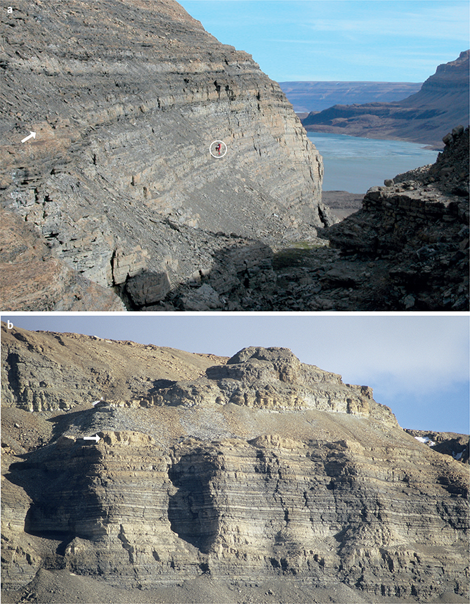
Fig. 5 Slusen Formation. a: View of the lower Slusen Formation at the type section above the western shores of the Øvre Midsommersø lake. Stacked pale weathering grainstone-dominated cycles at the base of the formation are succeeded by darker mid-ramp and outer ramp facies (above encircled figure); a microfauna with late Ediacaran affinities was obtained from samples taken laterally from the arrowed horizon. b: The Slusen Formation about a kilometre west of the type section showing the development of thrombolitic microbial mounds at a discrete horizon (arrowed) in the middle of the formation.
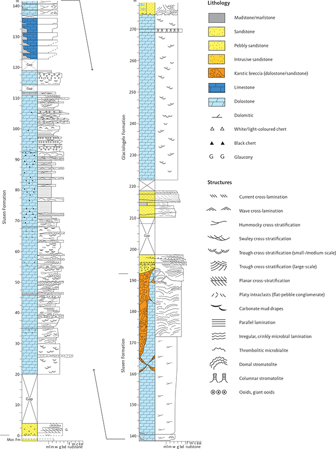
Fig. 6 Type section of the Slusen Formation and reference section of the Glaciologelv Formation, western Øvre Midsommersø (Fig. 1b, locality 1). The Slusen Formation mounds illustrated in Fig. 5b occur laterally to the type section at the 117 m level; due to access difficulties, the succeeding cyclic interval (123–136 m) was estimated from photographs. Details of the primary cyclicity in the upper 50 m of the Slusen Formation are obscured by intense karst-related fracturing and brecciation. The Glaciologelv Formation reference section illustrates the fluvial sandstones at the base of the formation, draping the top-Slusen Formation karst surface. Mor: Morænesø. Lithology/grain-size abbreviations: ml: marlstone. m: lime mudstone. w: wackestone. g: grainstone. bd: boundstone. Rudstone subdivisions: f: fine. m: medium. c: coarse. co: cobble. The accompanying legend is applicable to Figs 8 and 12.
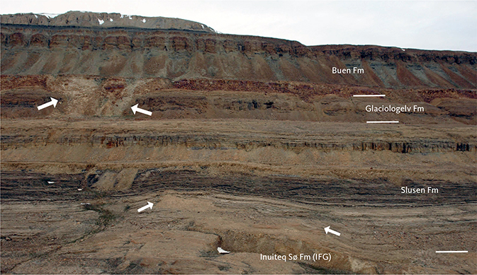
Fig. 7 Portfjeld Group on the northern side of the Nedre Midsommersø lake, approximately 1 km west of the Slusen Formation reference section and the Glaciologelv Formation type section. At this locality, the basal unconformity is markedly irregular, the lower Slusen Formation onlapping prominent knolls of weathered Proterozoic sandstone (small arrows). The upper Glaciologelv Formation is disrupted by a wide doline (large arrows) infilled with basal Buen Formation sandstone. IFG: Independence Fjord Group.
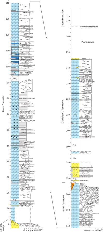
Fig. 8 Reference section of the Slusen Formation and type section of the Glaciologelv Formation, Nedre Midsommersø (Fig. 1b, locality 2), exhibiting the cyclic nature of both the Slusen Formation and the carbonates of the Glaciologelv Formation. Ind.: Independence. Lithology/grain-size abbreviations: ml: marlstone. m: lime mudstone. w: wackestone. g: grainstone. bd: boundstone. Rudstone subdivisions: f: fine. m: medium. c: coarse. co: cobble. For legend, see Fig. 6.
Lithology. The Slusen Formation is a carbonate-dominated succession composed mainly of dolostones with subordinate limestones; siliciclastic facies occur locally at the base and top of the formation (Figs 6, 8). The carbonates show a range of weathering colours, from pale silvery grey through fawn – khaki and mid grey – brown to dark grey or black. These commonly alternate cyclically on various scales to produce a strikingly banded or striped outcrop, which is readily traced across southern Peary Land (Figs 3a, 5b, 7). The uppermost, karstified dolostones weather a rusty red-brown colour (Fig. 3b). Although mainly dolomitised, relict structures (often spectacularly preserved) record a spectrum of carbonate facies from cherty laminated mudstones through wackestones and ooid–intraclast packstones to ooid grainstones; the packstone–grainstone facies often show trough cross-bedding or hummocky cross-stratification. Microbial fabrics are common, ranging from crinkly lamination and micro/mesoscale columnar and hemispherical domal stromatolites to thrombolitic bioherms and biostromes.
A thin siliciclastic unit, up to 5 m thick, occurs locally at the base of the formation. It comprises medium- to coarse-grained sandstone, sometimes pebbly or glauconitic, showing planar cross-bedding in 5–20 cm sets, locally forming herringbone couplets, that indicate dominant northward directed palaeocurrents (Kirkland et al. 2009). North of Nedre Midsommersø, the basal unconformity is markedly irregular (Fig. 7), and the relict regolithic topography is onlapped by coarse pebble – cobble breccio-conglomerates that wedge out laterally within only a few metres; the pebble and cobble clasts are composed of quartzite derived locally from the underlying Inuiteq Sø Formation (Independence Fjord Group).
The succeeding dolostone-dominated succession comprises two discrete sedimentary packets that often form separate topographic steps along the north side of the Midsommer lakes. The lower packet (c. 120 m thick) begins with a 25–30 m thick succession of pale to mid grey weathering dolostones showing relict grainstone fabrics (ooid/peloid/intraclast) and trough cross-bedding (Fig. 9a), with thin microbial (stromatolitic) beds in places. This basal unit darkens upwards, passing up into an interval (25–40 m thick) of stacked coarsening upward cycles, typically 2–5 m thick, comprising dark laminated dolostones (mudstone/wackestone) grading up into swaley and hummocky cross-stratified packestones and grainstones, locally capped by a thin stromatolitic bed (Figs 6, 8). This cyclic succession passes up into a distinctive dark grey – black dolostone unit (typically 25–35 m thick) that is an important marker throughout the outcrop of the Slusen Formation (Figs 3, 5–8, 9b; O’Connor 1979); the fossil biota recorded by Willman et al. (2020) was derived from samples collected near the base of this unit. Although laminated, cherty carbonate mudstone fabrics dominate (Fig. 9c), this dark dolostone unit also includes thin, often lenticular thrombolitic microbialites and isolated wackestone/packstone beds showing hummocky cross-stratification. The lower sedimentary packet of the Slusen Formation is capped by a thick (7–10 m), poorly stratified unit of thrombolitic dolostone that forms a prominent cliff in most sections (Figs 3a, 5b). Though a laterally persistent biostromal body in eastern exposures (Fig. 3a), it shows a more complex architecture in the west, around Øvre Midsommersø, forming laterally impersistent mounds with depositional relief of up to 7 m that developed atop stratiform ooid grainstone bodies (Fig. 9b, d). Farther west, this unit loses its prominent, cliff-forming character.
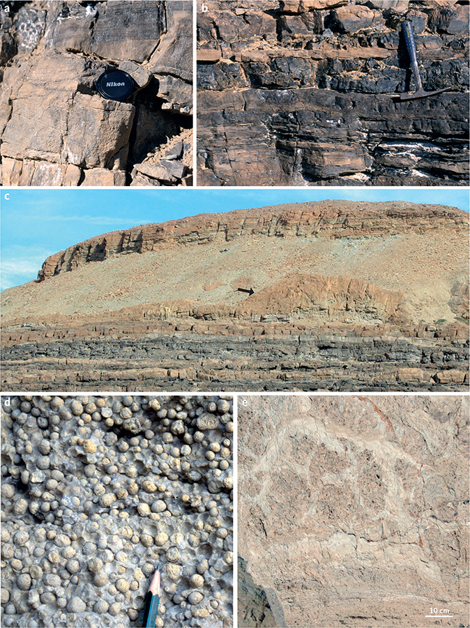
Fig. 9 Lower Slusen Formation, representative lithologies from the type area, Øvre Midsommersø. a: Trough cross-bedded grainstones (dolostones); type section, 23 m above base. b: Dark laminated dolostones and black cherts; type section, 83 m above base. c: Slusen Formation, c. 1 km west of the type section, showing the abrupt boundary (equivalent to 92.5 m in the type section) between the dark outer ramp dolostones and the overlying cyclic ooidal grainstones and capping thrombolitic mounds. The relief on the arrowed mound is about 5 m. d: Giant ooids; grainstones immediately beneath the mounds illustrated in Fig. 9c. Pencil tip for scale. e: Internal thrombolitic fabric typical of the microbial mounds illustrated in Fig. 9c; photograph from a fallen slab about 4 km west of the type section.
The upper sedimentary packet of the Slusen Formation (c. 75 m thick) is characterised by a lower, cyclic, mixed siliciclastic–carbonate succession that becomes more homogeneous and carbonate-dominated upwards and is capped by a rusty, locally irregular karstic surface (Figs 3, 6, 8). The lower 25–30 m consists of well-developed cycles, 1.5–4 m thick, composed of limestones and/or dolostones interbedded with green-grey or purple marlstones (Figs 3, 6, 8, 10a, b); individual cycles are rich in marlstone at the base and carbonate-dominated at the top. Pale grey limestones are locally preserved in the lower 10–15 m, passing up or laterally across a diachronous front into brownish weathering dolostones (Fig. 10a). The carbonate beds, typically 5–20 cm thick, comprise wackestones, packstones and intraclastic grainstones showing hummocky cross-stratification. Bed bases are often defined by flat-pebble conglomerate divisions up to several tens of centimetres thick with scoured bases and megarippled undulating tops; complex, opposed imbrication fabrics are common. With decreasing siliciclastic content upwards, the succeeding c. 25–30 m thick dolostone succession comprises amalgamated hummocky and swaley cross-stratified cycles (Figs 6, 8). These grade up into the uppermost Slusen Formation unit (25–30 m thick) that retains the cyclic pattern but is increasingly dominated up-section by microbial dolostones showing regular mesoscale, laterally linked hemispherical domes (0.5–2 m diameter, 20–40 cm synoptic relief; Fig. 10c). Where the karstic overprint is less penetrative, it is evident that this stromatolitic dolostone facies alone forms the upper 10–20 m of the formation.
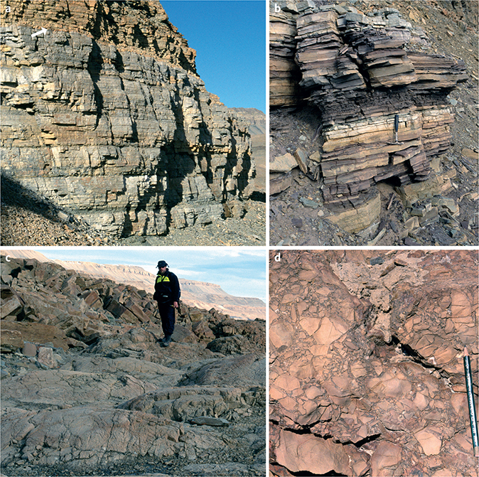
Fig. 10 Upper Slusen Formation, representative lithologies from the type area, Øvre Midsommersø. a: Marlstone – limestone/dolostone cycles equivalent to the 123–140 m interval in the type section (Fig. 6); photograph about 4 km west of the type section, the cycles are 2–3 m thick. The weathering change from pale grey (limestone) to orange (dolostone) at the top of the image (arrowed) marks the dolomite front. b: Close-up of the marlstone – limestone/dolostone cyclic facies; the thin, lenticular carbonate beds (e.g. at the hammer) commonly display hummocky cross-stratification. c: Mesoscale domal stromatolites characterise the upper levels of the Slusen Formation (172–194 m in the type section (Fig. 6) and 141–167 m in the reference section (Fig. 8)); photograph from c. 1 km east of the type section. d: Karstic breccia, uppermost Slusen Formation, type section.
The karstic nature of the upper boundary of the Slusen Formation (see Boundaries) becomes increasingly evident in the upper c. 20 m of the formation. Dissolution cavities and vugs with early haematitic linings and drusy carbonate cements are common, and sub-vertical brecciated fracture planes coalesce to form irregular zones of clast-supported breccia (Fig. 10d). Sandstone matrix becomes increasingly common in the karstic breccias upwards. The uppermost levels of the formation are thus very variable laterally, passing from reddened and fractured yet in situ stromatolitic dolostones to broad zones (metres to tens of metres across) of sandy breccia, both clast- and matrix-supported.
Fauna, flora and age. The Slusen Formation contains a variety of microscopic fossils, but no macroscopic fossils have been discovered (Peel 1988; Willman et al. 2020; Peel & Willman 2022; Willman & Peel 2022). The microscopic, phosphatised fossils were derived from dolostone near the base of the distinctive dark dolostone unit in the lower part of the formation (Fig. 5a) and consist of a three-dimensionally preserved biota including acritarchs, cyanobacteria, red algal thalli, problematic tubular fossils and putative eggs and embryos. This well-preserved and diverse assemblage is similar in composition and preservation to the Ediacaran age Doushantuo Formation Lagerstätte in China (e.g. Xiao et al. 1998, 2014; Zhang et al. 1998).
A negative carbon isotope excursion of –12‰ expressed across the reference section of the Slusen Formation currently supports a late Ediacaran age assignment (Willman et al. 2020; Rugen et al. 2022). A precise correlation with the global Neoproterozoic carbon isotope profile remains unclear, however, as the nature of the chemostratigraphic trend shares similarities with both the global Shuram Excursion of late Ediacaran age and the BAsal Cambrian Excursion (BACE; Rugen et al. 2022).
The combined palaeontological and isotopic evidence indicates a general late Ediacaran, Neoproterozoic age for the Slusen Formation.
Depositional environment. The facies represented in the Slusen Formation testify to a storm-dominated carbonate ramp setting. The shallow-water inner ramp was characterised by siliciclastic tidal sands, carbonate sand shoals and stromatolite tracts, the mid-ramp by carbonate storm sands, and the outer ramp by carbonate muds. Microbial bioherms and biostromes developed during a major ramp drowning event.
Boundaries. In southern Peary Land and northern Heilprin Land, the Slusen Formation rests unconformably on sandstones of the Inuiteq Sø Formation, part of the Palaeoproterozoic–Mesoproterozoic Independence Fjord Group (Fig. 11a), or locally on erosionally truncated outliers of the Morænesø Formation (Neoproterozoic tillites and carbonates of inferred Marinoan affinity; Kirkland et al. 2009); for details of Proterozoic stratigraphy, see Sønderholm & Jepsen (1991). Being observed in cliff sections, the basal unconformity appears planar on a large scale but locally shows significant relief. On the northern shores of Nedre Midsommersø, for example, relief of up to 30 m is evident, the lower dolostones of the Slusen Formation onlapping knolls of deeply weathered regolithic sandstone of the Independence Fjord Group (Fig. 7). This positive relief is locally highly asymmetric, with steep, locally subvertical western and northern slopes, possibly representing degraded fault scarps.
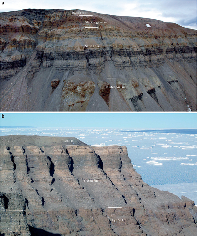
Fig. 11 a: Portfjeld Group at northern Rundfjeld, south of Nedre Midsommersø, showing the basal unconformity overlying Independence Fjord Group quartzites and sills (dark, right); central conglomeratic wedge in the Inuiteq Sø Formation potentially related to pre-Portfjeld Group faulting (see Fig. 7). b: The Slusen Formation at Kap Bernhard, NE J.C. Christensen Land (Fig. 1a), unconformably overlies the karstified(?) Fyn Sø Formation (Neoproterozoic Hagen Fjord Group) and is overlain at a sharp flat unconformity by the Buen Formation. The Glaciologelv Formation is absent in this eastern area.
South-east of the type area, the Slusen Formation unconformably overlies shelf strata on the western margin of the Hekla Sund Basin, a Neoproterozoic extensional basin of Iapetus affinities (Clemmensen & Jepsen 1992; Sønderholm et al. 2008). In south-eastern Heilprin Land (Fig. 1), the Slusen Formation unconformably overlies the Catalinafjeld Formation (Hagen Fjord Group), whereas at Kap Bernhard, north-east J.C. Christensen Land, the Slusen Formation rests unconformably on dolostones of the Fyn Sø Formation, the uppermost formation of the Hagen Fjord Group (Fig. 11b). The unconformity surface at Kap Bernhard is planar although exposures at the northern end of the cliff-line reveal normal faults that displace strata of the Fyn Sø Formation yet are truncated at the base Slusen Formation unconformity.
In southern Peary Land, and probably west to the head of Nordenskiöld Fjord, south of Freuchen Land (Fig. 1), the upper boundary of the Slusen Formation is a distinctive, reddened karstic unconformity, overlain by cross-bedded coarse-grained pebbly sandstones or poorly exposed fine-grained siliciclastic sediments at the base of the Glaciologelv Formation, as defined here (Figs 3b, 6, 8). Although sub-planar and occurring at a consistent stratigraphic level, this unconformity is locally irregular in detail with prominent mounds of relict dolostone projecting up to 5 m above depressions floored by sandy karstic breccia. At Kap Bernhard, north-east J.C. Christensen Land, the Glaciologelv Formation is absent due to regional south-eastward truncation at the base of the Buen Formation (upper lower Cambrian); the Slusen Formation is thus overlain unconformably by the Buen Formation at this locality (Fig. 11b).
Distribution. The Slusen Formation is recognised from the head of Nordenskiöld Fjord, south of Freuchen Land, eastwards along Wandel Dal in southern Peary Land to easternmost Valdemar Glückstadt Land. Accessible, well-exposed sections are particularly common along the northern shores of the Midsommer lakes in Wandel Dal. Exposure in the eastern outcrops, in J.C. Christensen Land and Valdemar Glückstadt Land, is generally poor, with the exception of the precipitous cliffs at Kap Bernhard (Fig. 11b).
3.2.2 Glaciologelv Formation
new formation
History. The succession referred here to the new Glaciologelv Formation previously formed the upper third of the Portfjeld Formation in southern Peary Land as defined by Jepsen (1971); the Glaciologelv Formation corresponds to units 18–20 of Jepsen (1971; Fig. 2).
Type section. About 1.5 km north of the small peninsula in the middle of the northern shore of Nedre Midsommersø (Figs 1b [locality 2], 7, 8; 82°15´N, 33°25´W); the section is at the head of the gully where the cross-bedded, grainstone-dominated dolostones that typify the formation are well-exposed.
Reference sections. Accessible, complete sections through the Glaciologelv Formation are scarce, and the type section at Nedre Midsommersø is supplemented by reference sections immediately north of the western end of Øvre Midsommersø (Figs 1b [locality 1], 6; 82°14´N, 36°06´W), and along the southern bank of Glaciologelv, a small river south of the head of Jørgen Brønlund Fjord (Figs 1b [locality 3], 12; 82°10´N, 31°18´W). The former illustrates details of the basal siliciclastic interval and the latter the uppermost c. 20 m of the formation, intervals that are incomplete or covered at the type section.
Thickness. Accessible sections are generally incomplete (see Figs 6, 8) but based on lateral correlation between type and reference sections, the Glaciologelv Formation is estimated to be about 100 m thick in southern Peary Land. The thickness probably varies by at least 20–30 m laterally, however, due to the clear irregularity of the karstic surfaces at the base and top of the formation, as observed in inaccessible cliff sections (Fig. 3).
Lithology. The Glaciologelv Formation is composed of three discrete elements that are recognised in all studied sections, albeit variably exposed and developed. The basal siliciclastic unit, 15–30 m thick, forms a recessive weathering ledge above the karstified top of the Slusen Formation (Figs 3, 7). It comprises a laterally variable alternation of prominent, rusty weathering lenticular sandstone bodies and more recessive finer-grained deposits. The sand bodies are up to 8 m thick and comprise pebbly coarse- to very coarse-grained sandstones showing large-scale trough cross-bedding (Fig. 13a), grading up to trough and planar cross-bedded, medium- to fine-grained sandstone and current-rippled fine-grained sandstones and heteroliths; the sedimentary structures indicate sediment transport towards the north (Kirkland et al. 2009).

Fig. 12 Reference section of the Glaciologelv Formation on the southern bank of the Glaciologelv river, south of Jørgen Brønlund Fjord (Fig. 1b, locality 3). This section illustrates the uppermost levels of the formation (generally poorly exposed or inaccessible in the Midsommersø sections) and details of the irregular karstified unconformity with the Buen Formation. Lithology/grain-size abbreviations: carbonate: ml: marlstone. m: lime mudstone. w: wackestone. g: grainstone. Siliciclastic: vf: very fine. f: fine. m: medium. c: coarse. vc: very coarse. For legend, see Fig. 6.
The middle and dominant unit of the formation (c. 50 m thick) comprises a uniform succession of mid grey-brown weathering dolostones, often reddening upwards, that show relict grainstone fabrics (coarse sand grade) and are typically trough cross-bedded (Figs 8, 13b). Finer-grained, hummocky cross-stratified intervals, c. 0.5 m thick, alternate with trough cross-bedded dolostone packets up to 6 m thick in the lower 30 m; the former intervals thin upwards and above 30 m, the succession is composed solely of the coarse, cross-bedded grainstone facies (Fig. 8). A distinctive c. 2 m thick columnar stromatolite bed marks this shift from cyclic to amalgamated grainstones (Figs 8, 13c). The upper boundary of this middle unit is a sharp, irregular scalloped surficial karst surface (karren), well exposed in the Glaciologelv section, south of Brønlund Fjord (Figs 12, 14a).
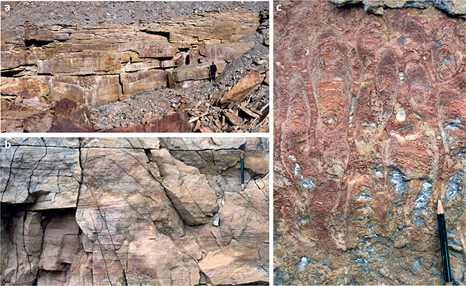
Fig. 13 Lower–middle Glaciologelv Formation, representative lithologies. a: Pebbly coarse- to very coarse-grained sandstones at the base of the Glaciologelv Formation showing large-scale trough cross-bedding; person for scale (right). Øvre Midsommersø reference section, 190–198 m. b: Trough cross-bedded grainstones (dolostones), type section 235 m; pencil (top right) for scale. c: Columnar stromatolites, type section, 232 m.
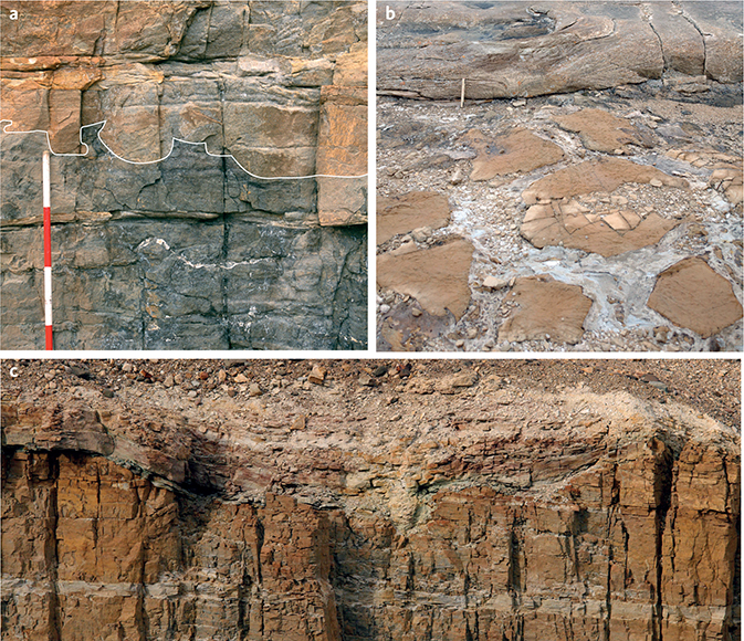
Fig. 14 Upper Glaciologelv Formation. a: Surficial karstic surface (karren) at the boundary between the cross-bedded dolostones of the middle Glaciologelv Formation and the overlying dolomitic sandstones; pedestals and scalloped depressions on the surface are outlined. Staff divisions are 20 cm; Glaciologelv reference section, 2 m (Fig. 12). b: Pale intrusive sandstones separating polygonal blocks of orange-brown dolomitic sandstone. Measuring stick (20 cm), top left, for scale; Glaciologelv reference section, 10 m (Fig. 12). c: Irregular reddened upper boundary of the Glaciologelv Formation draped by pale sandstones of the Buen Formation. Estimated up to 5 m relief on the surface at this locality. Glaciologelv reference section, 21.5 m (Fig. 12).
The upper unit of the Glaciologelv Formation is a c. 20 m thick succession of cross-bedded siliciclastic sandstones, often with carbonate intraclasts and a dolomite cement, and sandy dolostones. The unit is covered in the type section and is best observed at Glaciologelv, south of Jørgen Brønlund Fjord (Figs 1b, 12). Sandwiched between the surficial exposure surface at the base (Fig. 14a) and the highly irregular karstic profile at the top (the Glaciologelv Formation – Buen Formation unconformity, see Boundaries), the depositional fabric of this unit is often obscure. In addition to karst-related collapse, the succession also shows evidence of in situ brecciation and extensive sand fluidisation and injection (Figs 12, 14b). The primary sedimentary lithologies are cross-bedded medium- to coarse-grained, locally coarse to very coarse pebbly sandstones interbedded with sandy dolostones (grainstones). Trough and less commonly planar cross-sets, locally in herringbone couplets, are typically 5–20 cm thick and indicate bimodal but dominantly eastward-directed palaeocurrents (Kirkland et al. 2009); hummocky cross-stratification is observed locally.
Fauna/flora and age. Fossils are not known from the Glaciologelv Formation. Its age is constrained stratigraphically by the Ediacaran biota of the underlying Slusen Formation (Willman et al. 2020) and by lower Cambrian (Cambrian Series 2, Stage 3–4) fossils from the upper member of the overlying Buen Formation (Vidal & Peel 1993; Peel & Willman 2018; Wallet et al. 2021). Trace fossils indicative of a lower Cambrian age are common in sandstones and siltstones in the upper part of the lower member of the Buen Formation (Bryant & Pickerill 1990). The stratigraphic expression of carbon isotopes at the type section of the Glaciologelv Formation has been suggested to best correlate with the global Cambrian, Fortunian record (Rugen et al. 2022). The Glaciologelv Formation is thus considered to be of probable earliest Cambrian age.
Depositional environment. The basal siliciclastic succession represents a fluvial setting (channels and overbank/interfluve), whereas the middle dolostones attest to high energy, shallow marine processes on a carbonate platform, probably shallowing from middle–upper shoreface to the intertidal zone and capped by an ephemeral exposure surface. The succeeding mixed siliciclastic–carbonate deposits are also shallow marine in origin, influenced both by storms and tides.
Boundaries. The Glaciologelv Formation is bounded by two karstic unconformities, often delineated by distinctive reddened, or locally greenish, horizons (Figs 3, 11a, 14c). The base (see Slusen Formation) is a subplanar surface but irregular in detail with up to at least 5 metres of demonstrable relief where positive zones of fractured yet broadly in situ upper Slusen Formation dolostone rise above dolostone breccia with a sandstone matrix. Siliciclastic sediments at the base of the Glaciologelv Formation drape this irregular surface. The upper karstic unconformity between the Glaciologelv Formation and the lower Cambrian (Cambrian Series 2, Stage 3–4) Buen Formation is strikingly irregular, ranging from a sharp, metre-scale sutured surface to deep depressions up to several hundreds of metres across and tens of metres deep filled with basal Buen Formation fluvial sandstones (Figs 3b, 7, 14c).
Distribution. The Glaciologelv Formation is recognised from the head of Nordenskiöld Fjord in the west across southern Peary Land, particularly in the type area in the valley of Wandel Dal, to the northern shores of Independence Fjord in the east (Fig. 1a). Farther eastward, the Glaciologelv Formation is probably present, albeit thin (<20 m), in northern J.C. Christensen Land (O’Connor 1979 and unpublished field notes) but is apparently truncated south-east of these exposures. At Kap Bernhard, eastern J.C. Christensen Land, the Glaciologelv Formation is absent, and the Buen Formation rests directly on the Slusen Formation (Fig. 11b); a similar relationship is likely in eastern Valdemar Glückstadt Land (O’Connor 1979 and unpublished field notes).
Acknowledgements
We extend our thanks to Jørgen A. Bojesen Koefoed, Chris Kirkland and Lars Stemmerik for assistance and companionship in the field, and to Stine Øckenholt and Jette Halskov for graphical inputs. Funding for fieldwork in 2006 from the Danish Natural Science Research Council is gratefully acknowledged. We also acknowledge the pioneer stratigraphic studies on this succession carried out by Hans Jepsen and Bernard O’Connor. This paper has benefitted greatly from the detailed and constructive comments provided by the two referees.
Additional information
Author contributions
JRI: Funding acquisition; Conceptualisation; Investigation; Visualisation; Writing – original draft; Writing – review and editing.
JSP: Conceptualisation; Investigation; Writing – original draft; Writing – review and editing.
SW: Investigation; Writing – original draft.
EJR: Investigation; Writing – original draft.
MS: Investigation.
PF: Investigation.
