 |
PREFACE  |
The Rødryggen-1 and Brorson Halvø-1 fully cored boreholes (Upper Jurassic – Lower Cretaceous), Wollaston Forland, North-East Greenland – an introduction
Abstract
Two fully cored boreholes, the Rødryggen-1 and the Brorson Halvø-1, were drilled in Wollaston Forland, North-East Greenland, in 2009 and 2010, respectively. The objective was to test the stratigraphic development of the Upper Jurassic – Lower Cretaceous mud-dominated succession in two different settings within the same fault block of a developing half-graben: centrally (Rødryggen-1 borehole) and near the uplifted crest of the rotating fault block (Brorson Halvø-1 borehole). The drilled deposits are equivalent to the principal petroleum source-rock sequence of the petroliferous basins of North-West Europe, Siberia, and basins off eastern Canada and provide a new record of an important phase of marine deoxygenation in the proto-North Atlantic region.
Citation: Bojesen-Koefoed et al. 2023: GEUS Bulletin 55. 8350. https://doi.org/10.34194/geusb.v55.8350
Copyright: GEUS Bulletin (eISSN: 2597-2154) is an open access, peer-reviewed journal published by the Geological Survey of Denmark and Greenland (GEUS). This article is distributed under a CC-BY 4.0 licence, permitting free redistribution, and reproduction for any purpose, even commercial, provided proper citation of the original work. Author(s) retain copyright.
Received: 26 May 2023; Revised: 27 Jun 2023; Accepted: 27 Jun 2023; Published: 21 Dec 2023
Competing interests and funding: None declared
The drilling campaign was funded by GEUS in collaboration with a large number of companies of the international petroleum industry, which for contractual reasons cannot be named.
*Correspondence: [email protected]
Keywords: stratigraphic boreholes, technical data, sedimentology, biostratigraphy, geochemistry
Abbreviations:
GEUS: Geological Survey of Denmark and Greenland
TD: total depth
GR: gamma ray
b.rfl.: below reference level
Edited by: Karen Dybkjær (GEUS, Denmark)
Reviewed by: Not peer reviewed.
1. Introduction
In 2007–2008, the Geological Survey of Denmark and Greenland (GEUS) initiated a major collaborative project with a consortium of companies of the international petroleum industry with the aim of addressing aspects of the geology of North-East and North Greenland, which were generally recognised as being insufficiently studied. One such aspect was the elucidation of the imperfectly known stratigraphy, sedimentary and lithologic development, and petroleum generation potential of the Upper Jurassic – Lower Cretaceous succession, equivalent to the well-known petroleum source-rock succession of the North Sea graben system, that is, the Kimmeridge Clay sensu lato. In North-East Greenland, the equivalent succession is widely distributed, and a considerable number of outcrop samples as well as some samples from cored shallow boreholes had been analysed previously, generally showing surprisingly poor petroleum generation potential. This was suspected to be the result of a combination of poor representation in the sample set of the more prolific intervals and adverse effects of weathering of outcrop samples. Hence, a drilling program was designed to obtain full core representation of the entire stratigraphic succession ranging from the Oxfordian to the Ryazanian. Three fully cored boreholes were planned, the first of which, the Blokelv-1 borehole, was drilled in Jameson Land in 2008. Blokelv-1 penetrated 233.8 m of Oxfordian–Volgian deposits, intruded by a few basaltic sills, as reported in a series of papers published in a volume edited by Ineson & Bojesen-Koefoed (2018). Two additional boreholes, both situated in Wollaston Forland, the Rødryggen-1 and Brorson Halvø-1 boreholes, were drilled in 2009 and 2010, respectively (Fig. 1). These boreholes aimed at testing that part of the succession not drilled by the Blokelv-1 borehole whilst attaining a reasonable stratigraphic overlap. The two boreholes were planned to be drilled centrally within, and near the uplifted crest of, a rather narrow half-graben, which evolved during the time of deposition, thus allowing the assessment of the effects of synsedimentary tectonic movements on the nature of the deposits. The main results of the drilling are reported in a series of papers dealing with stratigraphy (Alsen et al. 2023, this volume): sedimentology and basin evolution (Hovikoski et al. 2023a, this volume), mineralogy and diagenesis (Olivarius et al. 2023, this volume) and organic geochemistry and petroleum potential (Bojesen-Koefoed et al. 2023, this volume). The aim of this paper is to introduce the location, drilled successions, drilling procedure and technical specifications of the Rødryggen-1 and Brorson Halvø-1 boreholes.
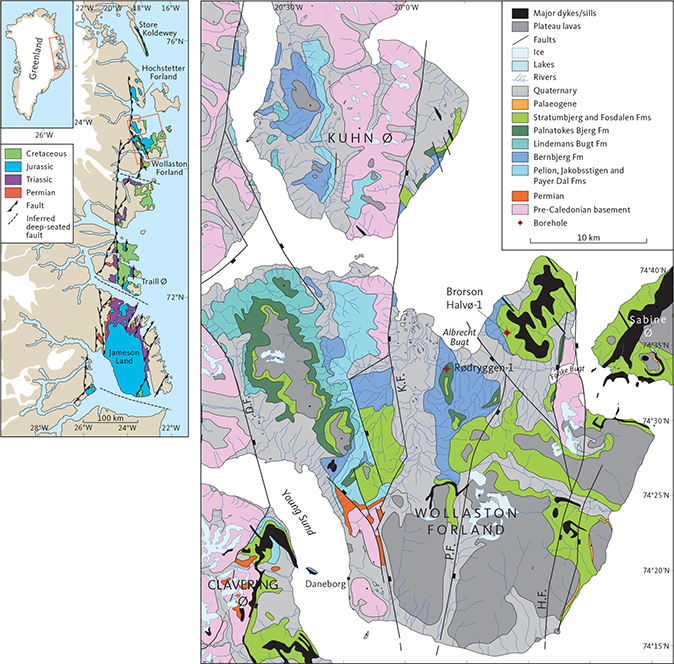
Fig. 1 Location maps. Overview map (left; Modified from Surlyk et al. 2023). Positions of the Rødryggen-1 and Brorson Halvø-1 boreholes in Wollaston Forland are shown on a simplified geological map (right; Modified from Surlyk et al. 2021). K.F.: Kuhn fault; P.F.: Permpas Fault; H.F.: Hühnerbjerg Fault; D.F.: Dombjerg Fault. The Dombjerg Fault was the main fault to control the position of the coastline during the Late Jurassic. The Permpas–Hühnerbjerg block(s) was bounded by the Kuppel and Hühnerbjerg Faults during the Late Jurassic.
2. Drilling and samples
2.1 Rødryggen-1 borehole
Drilling and technical specifications of the Rødryggen-1 fully cored borehole are summarised in Table 1. The Rødryggen-1 borehole was drilled from 27 July to 16 August 2009 at the Rødryggen locality, central Wollaston Forland. The drilling rig and the drill camp were mobilised by helicopter (sling and cabin load) from the military station at Daneborg approximately 30 km to the SSW of the drill site (Fig. 1). Rødryggen (“Red Ridge”) is a prominent NS-oriented, elongated hill, separating two broad depressions: Storsletten to the west and Sumpdalen to the east. The drill-site was selected during the 2008 field season by Henrik Nøhr-Hansen and Jørgen A. Bojesen-Koefoed. The well location was chosen with the aim of testing the Upper Jurassic – Lower Cretaceous succession centrally in the westward-tilted Permpas–Hühnerbjerg fault block. The rig was placed on outcrops of the bright yellow-weathering mudstones of the Albrechts Bugt Member of the Palnatokes Bjerg Formation (Figs 2 and 3). Debris from the overlying Rødryggen Member of the Palnatokes Bjerg Formation unit imparts a conspicuous red colour to the Rødryggen hill and thus forms the basis for its name. The rig and the drilling team spent 22 days on the location, with only 11 effective days of drilling. The marked discrepancy between time on location and time spent on active drilling was caused by prolonged periods of very bad weather with strong winds and large volumes of snow and rain, which tended to liquefy the upper decimeters of the very muddy ground, thus creating massive problems for camping and for the stability of the rig.
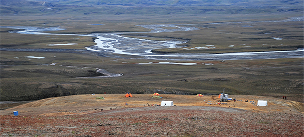
Fig. 2 The Rødryggen-1 drill-site and camp, viewed approximately towards the west with the broad plain of Storsletten as backdrop (Photo: Annette Ryge). The rig was placed on the brightly coloured, yellow-weathering mudstones of the Albrechts Bugt Member (Palnatokes Bjerg Formation). The overlying Rødryggen Member (Palnatokes Bjerg Formation) in the foreground consists of purple to brick-red mudstones. Debris from this unit imparts the slopes of the landscape with a reddish colour that can be seen from afar, and from which is derived the location’s name Rødryggen, meaning “the red ridge.”
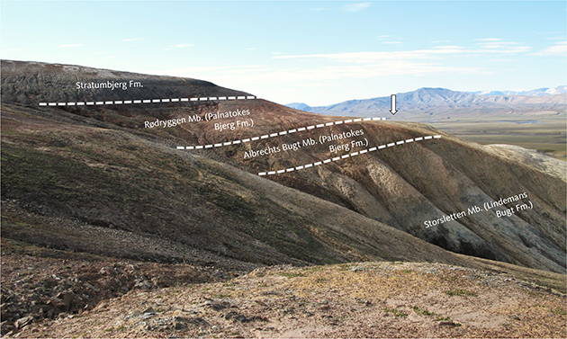
Fig. 3 Section at Rødryggen viewed approximately from the north in 2008 when the drill-site was selected. Arrow indicates the approximate position of the borehole (Photo: Jørgen A. Bojesen-Koefoed).
The drilled succession is summarised in Table 2. The borehole penetrated 24.4 m of the Albrechts Bugt Member of the Palnatokes Bjerg Formation (light grey, yellow-weathering mudstones), followed by 72.6 m of the Lindemans Bugt Formation (dark grey/black laminated mudstones), a succession that was later defined as a new member, the Storsletten Member (Alsen et al. 2023, this volume). Beneath the Lindemans Bugt Formation, the borehole encountered 137.5 m of the Bernbjerg Formation (dark grey mudstones with occasional thin sandstone stringers and carbonate-filled thin fractures) before reaching total depth (TD) at 234.5 m below reference level (b.rfl.; top of casing). For details of the sedimentology, the mineralogy and diagenesis, and the organic geochemistry and petroleum potential see Hovikoski et al. (2023a, this volume) Olivarius et al. (2023, this volume) and Bojesen-Koefoed et al. (2023, this volume), respectively.
A total gamma-ray (GR) wireline log was collected in the borehole over the interval 0–209 m b.rfl., later supplemented by spectral-GR and bulk-density scanning of the cores over the interval 192.56 m to 234.54 m. The wireline log and the scanned GR core logs were then merged into one single total GR log.
The core recovery was 99%, with losses of core primarily occurring in the uppermost part of the succession, which was affected by surface weathering. The core quality was mostly excellent, with significant fracturing only found in intervals scattered throughout the succession, whilst coherent core in general predominated (Fig. 4). A total of 70 whole core samples for gas analysis, each c. 10 cm in length, were collected on site at approximately 3 m intervals and stored in airtight containers immediately after the cores were extruded from the core barrel. A large number of samples for different types of analyses were subsequently collected from the core. Most of these analyses are reported in papers by Alsen et al. (2023, this volume), Hovikoski et al. (2023a, this volume), Olivarius et al. (2023, this volume) and Bojesen-Koefoed et al. (2023, this volume). Additional data are reported by Hovikoski et al. (2023b), whereas a minor volume of miscellaneous data that have not found a place in the publications listed above are reported in internal GEUS reports.
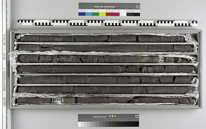
Fig. 4 Example of core quality and recovery, Rødryggen-1 borehole, 59.81 – 66.16 m, Lindemans Bugt Formation (Photo: John Boserup).
2.2 Brorson Halvø-1 borehole
Drilling and technical specifications of the Brorson Halvø-1 fully cored borehole are summarised in Table 1. The Brorson Halvø-1 borehole was drilled from 30 July to 14 August 2010 at Brorson Halvø (Brorson Peninsula), northeastern Wollaston Forland. The Brorson Halvø-1 borehole was the second to be drilled during the 2010 field season, and the drilling rig and camp were mobilised from the first drill site on the island of Store Koldewey, approximately 200 km north of the Brorson Halvø drill-site (Fig. 1). The rig frame was transported by helicopter in one piece as sling load directly from the Store Koldewey drill site to the Brorson Halvø drill site. The drilling team, the drill camp and other equipment were moved either directly by helicopter or via Danmarkshavn by Twin Otter plane to Daneborg and from there by helicopter to the Brorson Halvø-1 drill-site. The original drill site was selected during the 2008 field season by Henrik Nøhr-Hansen and Jørgen A. Bojesen-Koefoed, later redefined by Morten Bjerager and Michael B.W. Fyhn in 2009, and eventually, for practical reasons, moved another few 100 m by Stefan Piasecki and Jørgen A. Bojesen-Koefoed in 2010 to secure a stable substratum for the rig. A consequence of this last relocation of the drill site was the drilling of part of the Stratumbjerg Formation and the entire Rødryggen Member of the Palnatokes Bjerg Formation, which was initially not planned.
The well location was selected with the aim of testing the Upper Jurassic – Lower Cretaceous succession near the uplifted crest of the westward-tilted Permpas-Hühnerbjerg fault block. The rig was placed on outcrops of the dark-grey mudstones of the Stratumbjerg Formation (Fig. 5). The rig and the drilling team spent 14 days on the location, with 10 effective days of drilling.
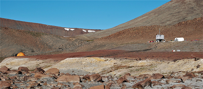
Fig. 5 The Brorson Halvø-1 drill site viewed approximately towards the ENE. The drill-rig stands on the dark grey mudstones of the Stratumbjerg Formation with the well-defined contact to the bright red Rødryggen Member clearly visible below. Downhill, the contact between the Rødryggen Member and the underlying Albrechts Bugt Member (yellow) stands out. The contact to the Storsletten Member (grey), in turn, underlying the Albrechts Bugt Member appears somewhat gradational, but in a clean section, it is very well defined (see Fig. 6; Photo: Annette Ryge).
The drilled succession is summarised in Table 2. The borehole penetrated 8.7 m of the Stratumbjerg Formation (dark-grey mudstones), followed by 21.3 m of the Rødryggen Member (purple to brick-red mudstones) and 7.5 m of the Albrechts Bugt Member (light grey, yellow-weathering mudstones) of the Palnatokes Bjerg Formation. Beneath the Palnatokes Bjerg Formation, the borehole encountered 8.0 m of the Lindemans Bugt Formation (dark grey/black laminated mudstones), later referred to the new Storsletten Member (Alsen et al. 2023, this volume), and eventually, 180.1 m of the Bernbjerg Formation (dark grey mudstones with occasional thin sandstone stringers and carbonate-filled, thin fractures). TD was reached at 225.6m b.rfl. (top of casing). Drilling was terminated due to notable water production from the borehole at TD. For details of the sedimentology, the mineralogy and diagenesis, and the organic geochemistry and petroleum potential, see Hovikoski et al. (2023a, this volume), Olivarius et al. (2023, this volume) and Bojesen-Koefoed et al. (2023, this volume), respectively.
A total GR wireline log was collected in the borehole over the interval 0–210 m b.rfl., later supplemented by spectral-GR and bulk-density scanning of the cores over the interval 193 m – 225.6 m. The wireline log and the scanned GR core logs were then merged into one single total GR log.
The core recovery was 99%, with significant losses of recovery mainly in the uppermost part of the succession, which was affected by surface weathering. The core quality was mostly excellent, with significant fracturing only found in intervals scattered throughout the succession, whilst coherent core predominated (Fig. 6). A total of 34 whole-core samples for gas analysis, each c. 10 cm in length, were collected on site and stored in airtight containers immediately after the cores were extruded from the core barrel. A large number of samples for different types of analyses were subsequently collected from the core. Most of these analyses are reported in papers by Alsen et al. (2023, this volume), Hovikoski et al. (2023a, this volume), Olivarius et al. (2023, this volume) and Bojesen-Koefoed et al. (2023, this volume). Additional data are reported by Hovikoski et al. (2023b), whereas a minor volume of miscellaneous data that have not found a place in the publications listed above are reported in internal GEUS reports.
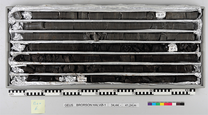
Fig. 6 Example of core quality and recovery, Brorson Halvø-1 borehole, 34.44–41.24 m, Albrechts Bugt Member of the Palnatokes Bjerg Formation (light grey) and the sharp boundary with the underlying Storsletten Member of the Lindemans Bugt Formation (dark grey; Photo: John Boserup).
2.3 Perspectives
The primary data from the three fully cored, complementary boreholes Blokelv-1, Rødryggen-1 and Brorson Halvø-1 are presented in Ineson & Bojesen-Koefoed (2018) and this volume. Together these cored sections represent a unique geological archive from a high latitude setting, recording a key period when super-regional deoxygenation prevailed in the marine waters of the proto-North Atlantic region. Though the significance of this archive may have waned commercially, given the imperative to adopt carbon-free energy sources, its continued importance lies in understanding the climatic, tectonic and oceanographic factors involved in watermass stratification, deoxygenation and carbon burial, as examined recently by Hovikoski et al. (2023b). It is predicted that this integrated core record will be the source of much multidisciplinary research in future years.
Acknowledgements
The drilling teams including John Boserup, Anders Clausen, Annette Ryge, Peter Turner, Lars (Lasse) Thomsson, Andreas Hjort Frandsen and Anders Pilgaard are thanked for their hard work and stamina, and for maintaining good spirits, particularly during the very challenging 2009 field season. The pilots Finn Rusanes and Göran Lindmark (both Air Greenland) are thanked for diligent sling-work under very difficult conditions. Twin Otter plane support by Nordlandair (Akureyri, Iceland) is gratefully acknowledged. Jesper Weiss Andersen and Thea Weiss Andersen (in 2009 only) did an excellent job running the logistics of the 2009 and 2010 expeditions.
Additional information
Author contributions
JABK: Conceptualisation; Writing – Original Draft; Funding Acquisition; Project Administration; Investigation; Writing – Review & Editing. PAL: Conceptualisation; Funding Acquisition; Investigation; Writing – Review & Editing. MBJ: Investigation; Writing – Review & Editing. JHOV: Investigation; Writing – Review & Editing. JI: Conceptualisation; Writing – Original Draft: Investigation; Writing – Review & Editing. PJ: Investigation. MOL: Investigation; Writing – Review & Editing. SP: Conceptualisation; Investigation; Writing – Review & Editing. HV: Investigation; Writing – Review & Editing.
Additional files
None provided
