MAP DESCRIPTION
Descriptive text to the Geological map of Denmark, 1:50 000, Møn 1511 I, 1511 IV and 1512 II
Stig A. Schack Pedersen*1 , Peter Gravesen1
1Geological Survey of Denmark and Greenland (GEUS), Copenhagen, Denmark.
Citation: Pedersen & Gravesen. 2022: GEUS Bulletin 51. 8336. https://doi.org/10.34194/geusb.v51.8336
Copyright: GEUS Bulletin is an open access, peer-reviewed journal published by the Geological Survey of Denmark and Greenland (GEUS). This article is distributed under a CC-BY 4.0 licence, permitting free redistribution, and reproduction for any purpose, even commercial, provided proper citation of the original work. Author(s) retain copyright.
Received: 04 Feb 2019; Accepted: 18 Apr 2021; Published (in Danish): 14 Dec 2021; Published (in English): 16 Dec 2022
Competing interests and funding: None declared.
Funded by GEUS.
*Correspondence: sasp@geus.dk
Keywords: Geological map, Quaternary stratigraphy, Cretaceous chalk, glacial tectonics, landslides
Abbreviations:
BP: years before present
OSL: optically stimulated luminescence
TL: thermoluminescence
GEUS: Geological Survey of Denmark and Greenland
LGM: Late Glacial Maximum
Edited by: Adam A Garde (GEUS, Denmark)
Translated by: Adam A Garde, 2022. This work was originally published in Danish (https://doi.org/10.34194/geusb.v48.8293)
Reviewed by: Helena Alexanderson (Lund University, Sweden) & Nikolaj Krogh Larsen (University of Copenhagen, Denmark)
Abstract
The geological map sheet Møn covers the island of Møn, the smaller adjacent islands Langø, Lindholm and Nyord as well as adjacent parts of Sjælland and Lolland. It comprises the geodetic map sheets 1511 I and 1511 II and areas on bordering sheets. Møn is surrounded by the Baltic Sea with the bay of Hjelm Bugt to the south, the straits of Grønsund and Ulvsund to the west, and the bays of Stege Bugt and Fakse Bugt to the north.
Møn is divided into three glaciomorphological areas, namely a high, hilly landscape of Høje Møn to the east, a hummocky to parallel ridge landscape to the west and areas of marine deposits around Nyord and Ulvshale. The composite ridge landscape of Høje Møn constitutes a glaciotectonic complex comprising four individual glaciodynamic sequences, with the hill Aborrebjerg as the highest point (143 m a.s.l.). The parallel ridge hills consist of thrust-fault-displaced chalk sheets with superimposed glacial deposits. The thrust sheets are up to 80 m thick, of which 60 m constitute Maastrichtian chalk. The vertical displacement of the thrust sheets is about 150 m measured from the primary, undeformed pre-Quaternary surface located 25–30 m below sea level. The pre-Quaternary surface consists of chalk of Late Maastrichtian age, which forms a carbonate platform in the subsurface of Møn about 27 m below sea level. Chalk displaced by glacial tectonics is not restricted to Høje Møn but also appears in smaller thrust sheets and rafts in the small-ridged landscape around Stege Nor. In the chalk sheets along Møns Klint, most of the Late Maastrichtian succession is exposed. Cliff sections with chalk are also exposed at Hvideklint along the south coast of the island. However, here the glaciotectonic shear deformation has commonly altered the lithology into a chalk glacitectonite.
The oldest Quaternary units deposited on the pre-Quaternary unconformity are Saalian till as well as sand and clay from the Eemian Interglacial. These units are overlain by Early Weichselian sand. The next Quaternary succession, the Ristinge Klint Till Formation, was deposited during the Ristinge ice advance in the early Middle Weichselian about 55 000–50 000 years ago. Then followed the Kraneled Formation (new formation) consisting of fluvial and lacustrine deposits. The following Klintholm Till Formation (adjusted formation) was deposited during the Klintholm ice advance 35 000–32 000 years ago. The Klintholm Till Formation is overlain by a more than 10 m thick unit of greyish glaciolacustrine clay with dropstones. Glaciofluvial sand with thin-layered intercalations of laminated mud and diamictites of the Kobbelgård Formation (new formation) are related to this unit and interpreted as deposited in a huge, partly ice dammed lake covering a large part of the present Baltic Sea and the southern part of Kattegat 32 000 to 28 000 years ago. The Kobbelgård Formation is overlain by sand and gravel of the Stubberup Have Formation (new formation) and tills of the Mid Danish Till Formation deposited by the NE Ice Advance from central Sweden about 23 000–20 000 years ago.
Relatively shortly after the NE ice had melted away, the Young Baltic Ice advanced from the eastern part of the Baltic area. North-directed compressive deformation during this advance created the glaciotectonic complex of Møns Klint including the new unit Møns Klint Glaciodynamic Sequence. In the southern part of the complex, a steeply inclined imbricated fan was formed; towards the foreland to the north, the thrust faults became gently dipping and the tip-zone of thrusting is located under the landslides at Liselund. The composite ridges form a characteristic hilly landscape with elongate crests trending E–W.
The curved coastline along Hjelm Bugt was formed by a glacial lobe, north of which a push moraine was built up. A number of spillways striking radially northward from the lobe were formed by meltwater discharged from its glacier ports, including the Borre, Maglemose and Røddinge depressions. Deposition of sand and gravel of the Ny Borre Formation (new formation) took place at this time. During the advance of the Young Baltic Ice over southern Denmark to the Eastern Jutland stationary line, a relatively thin lodgement till of the Lolland Till Formation was deposited, which is rich in chalk due to its truncation of the upthrusted chalk sheets.
Towards the end of the Weichselian glaciation c. 17 000 years ago, the Young Baltic Ice melted back, leaving a residual ice cap in Skåne from where a recessive ice advance towards south-west reached Møns Klint, resulting in superimposed glaciotectonic deformation. During the Late Weichselian, freshwater lakes in the Hjelm, Tøvelde and Høje Møn areas were filled by clay and gyttja, with deposition that continued into the Holocene.
During the Holocene, the former spillways were turned into fjords during the Atlantic transgression. Marine deposits mirroring the Littorina Sea are thus found in Maglemose and Borre Sømose. After the Atlantic transgression had established a sea level more or less corresponding to that of today, accretion of marine forelands and formation of a spit system started. In particular, this is the case for the areas of Ulvshale and Nyord. At the same time, vegetation migrated out into the numerous fjords, and peat began to accumulate. The last phase of sedimentation is confined to the formation of beach ridges in the coastal areas, typically covered by aeolian dunes, as can be seen on the coast at Klintholm Havn and Råbylille as well as along the north-eastern coast of Ulvshale.
Introduction
Topography
The geological map sheet Møn at scale 1:50 000 comprises the northern part of the topographic map sheet 1511 I, the southern half of 1512 II and a smaller part of 1511 IV (Fig. 1). It covers the island of Møn and the surrounding sea with the islands of Nyord, Lindholm and Langø, as well as smaller parts of south-eastern Sjælland and north-eastern Falster. The map area is located within 11°15’–11°42’ E and 54°47’–55°04’ N. All place names mentioned in the text are found in the map figures here and the accompanying map sheet (available online as a supplementary file and as a supplement to the printed version.)
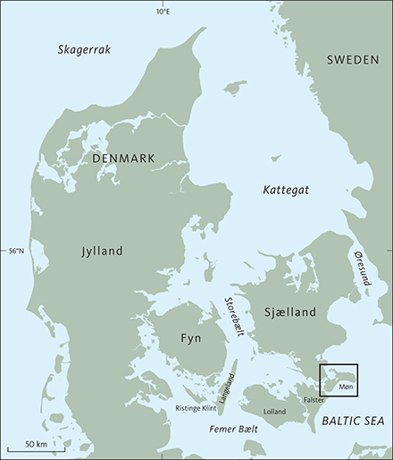
Fig. 1 Index map of Denmark with the position of the map sheet Møn.
The part on south-eastern Sjælland covers a small triangular area extending from Kalvehave in the north to Sandvig Kohave with the forest of Viemose Skov to the south, and westwards from Kalvehave to Langebæk. In the west, the area reaches an altitude of 46 m a.s.l. and consists of a morain plateau sloping gently towards the coasts, where Holocene marine deposits of clay and sand occur in several places, mainly at Kindvig Hoved.
A small part of the map sheet area on north-eastern Falster next to Grønsund north of Korselitse Østerskov and east of Stubbekøbing consists of till and Holocene clay deposits in Noret. Towards Grønsund Færgebro and along the coast towards Grønsund, the angular foreland also comprises marine deposits, mainly sand, gravel and beach cobbles of flint (Klint et al. 2017).
Based on the topography, Møn comprises three characteristic geomorphological terrains: (1) the high, hilly landscape of Høje Møn, (2) the glaciomorphological landscape around Stege Nor, and (3) the flat marine foreland around Nyord and Ulvshale. The highest part of Møn is in Store Klinteskov, the woodland that characterises Høje Møn. Aborrebjerg at 143 m a.s.l. forms a marked ridge above the Aborresø lake. Several other hills, including Kongsbjerg, Lollikebakke, Lindebakker and Store Ørnebjerg, reach elevations above 130 m. Lakes with the highest altitude of water table in Denmark, almost 90 m a.s.l., are located here, namely Aborresø, St. Geddesø and Hunesø. The most dramatic topography is found at Dronningestolen with an almost vertical fall of 130 m to sea level.
A N–S-trending lowland around Borre Sømose and Busemarke Mose with elevations down to only 1 m above sea level separates Høje Møn from the glaciomorphological landscape around Stege Nor with general elevations around 25 m and local hilly areas up to c. 40 m above sea level.
Møn’s surface is dominated by glacial Weichselian sediments with a high content of chalk, apart from large areas with Holocene deposits at Kostervig, Nyord, Ulvshale, Maglemose, Borre Sømose, Busemarke Mose, Råbylille Sø and Råby Sø. Particularly Høje Møn with Møns Klint and Hvideklint at Hjelm Bugt are examples of glaciotectonic cliffs with intercalations of large chalk sheets within till and meltwater deposits, with characteristic surface expressions particularly in the former area.
All of the flat marine foreland at Ulvshale lies between 1–3 m a.s.l. The highest elevations are elongate aeolian ridges deposited on beach ridges. The dammed area at Klostervig and former fjord areas such as Borre Sømose and Maglemose also belong to this landscape group. The southernmost point of Møn at Hårbølle Havn constitutes a marine angular foreland. Large parts of Møn’s coasts, especially in the south and east, but also in the north-east, consist of modified cliffs separated by marine forland. The coast to the west and south from Ulvshale is lobate, with the largest embayments at Stege Nor and Fanefjord.
Hjelm Bugt, Fakse Bugt and Stege Bugt, which partly encircle Møn, are shallow marine areas with few incisions of deeper sounds such as Grønsund between Møn and Falster (up to 23 m deep) and Ulvsund between Sjælland and Møn (up to 18 m deep). There are only a few small islands in these waters; Nyord and Langø are the largest.
Methods
The systematic geological mapping of the Danish land surface is traditionally also seen as a mapping of the Quaternary geology, because more than 90% of the land surface consists of Quaternary deposits. The mapping is carried out by the Geological Survey of Denmark and Greenland (GEUS) by walking through the landscape with a hand auger. At intervals of c. 100 m, a soil sample is collected at 1 m depth, attached to a small groove at the tip of the spear. The sample thus represents the subsurface material below the soil horizon and any cultural layers. The nature of the collected sample is determined on location and noted on a field map. In this way, boundaries between different deposits can be determined in the field, and a sufficient number of observations within each mapped polygon is ensured. The sample spacing may commonly be closer than 100 m, especially where geological boundaries need to be established (Gravesen et al. 2006; Jakobsen et al. 2015). Information from road cuttings, gravel pits, other digging activity and coast profiles is also used.
In the field, about 40 different types of lithological units are distinguished and marked on a field map at scale 1:25 000 with their appropriate symbols. These preliminary field maps are digitised and stored in GEUS’ database and are accessible at www.geus.dk. They constitute the basis for the published geological map.
The principles of establishing the different types of Quaternary deposits are described in Pedersen et al. (2015). In the following descriptions, each unit is assigned to a Marine Isotope Stage (MIS), following Cohen & Gibbard (2012). All age data presented in this map sheet description follow the systematics of Houmark-Nielsen et al. (2017).
The data collected during the systematic geological surface mapping is stored in GEUS’ archives. Seventy per cent of the land area shown on the map sheet is till, which amounts to 218 km2 on Møn itself besides smaller areas on Sjælland and eastern Falster. The sandy–clastic glacial deposits are dominated by meltwater sand and gravel, which cover 11% of the land surface. The remaining part mainly comprise Holocene marine and freshwater deposits (10 and 7%, respectively) besides chalk (1%) mainly on Høje Møn, as well as lakes and unmapped areas of towns, roads (1%).
Since around 1985, the cliffs on southern, eastern and northern Møn have been subject to several studies including several unpublished MSc dissertations. The results of raw material and groundwater investigations have been published in various reports. Results from all these studies have been included in the present map sheet description.
History of geological mapping on and around Møn
The first geological observations on Møn were published by Pontoppidan (1768), who demonstrated the geological structure of the southern part of Møns Klint from Vidskud via Græderen and Sommerspiret to Dronningestolen in a wood carving (see section on Møns Klint).
Puggaard (1851, 1852) performed a meticulous measurement of the structures all along Møns Klint and used this to describe the geological structure of the entire island. Puggaard fully supported a glaciotectonic mechanism for the formation of Møns Klint, but it was not generally accepted prior to Johnstrup’s (1874) publication, which stated that the chalk sheets were formed by pressure from an E–W-directed Baltic ice stream through the Baltic Sea. Furthermore, Johnstrup pointed out the correlation between Rügen and Møn, and concluded that at both sites the chalk sheets with their cover of till were pushed up and imbricated.
K.A. Grønwall suggested already in 1906 that a geological map of the entirety of Møn should be produced. Hintze (1937) published a map of Høje Møn, which retained a block-tectonic interpretation of the deformation structures in Møns Klint. All subsequent studies support a glaciotectonic interpretation (Konradi 1973; Berthelsen et al. 1977; Pedersen 1988, 2000, 2011; Houmark-Nielsen 1994). Hintze (1937) interpreted all depressions on his map, which had no outlet, as some sort of karst phenomena, although almost all were caused by melting of dead-ice bodies left behind when the Young Baltic Ice retreated.
Milthers (1948) compiled a Quaternary map of Denmark at scale 1:320 000. However, on Møn, he only differentiated between till landscapes, dammed marine deposits and beach ridge complexes.
V. Haarsted presented a geomorphological map and a map of Quaternary deposits of Møn at scale 1:20 000 at a meeting of the Danish Geological Society, January 1955. An overview map in the minutes from the presentation contains a summary of the geological features, where elongate ridges are interpreted as ice stationary lines. Valleys and eskers are also marked (Haarsted 1956).
A compilation of Quaternary maps of Denmark at scale 1:200 000 (Pedersen 1989) included information from drilling and aerial photographs. This allowed a designation of Høje Møn as consisting of chalk, and a few chalk sheets were shown in the easternmost part of the island.
The mapping for the present map sheet of Møn was performed by several different geologists and at various times. V. Haarsted, who was headmaster at the secondary school of Holte Gymnasium, carried out his mapping until 1959. V. Münther and A.V. Nielsen mapped smaller areas between 1966 and 1972. The present authors completed the mapping in 2004–2006, following the publication of a preliminary map of eastern Møn (Pedersen & Gravesen 2005).
Pre-Quaternary deposits
Late Cretaceous (99.6–66.0 Ma) chalk underlies Møn’s Pleistocene deposits. Møn is located on the southern part of the Ringkøbing–Fyn High (Sorgenfrei & Buch 1964; Sorgenfrei 1966: Håkansson & Pedersen 1992; Surlyk et al. 2013). In this region, chalk and limestone deposits about 500 m thick were laid down, whereas the equivalent deposits in the Danish Basin to the north are up to 2000 m thick (Surlyk et al. 2013). Most of these deposits are chalk. Relatively thin layers of chalk (<500 m thick) also occur in the German Basin south of the Ringkøbing–Fyn High (Surlyk et al. 2013).
There are no deep boreholes on Møn. The nearest one is the 2.5 km deep Ørslev-1 borehole on Falster, drilled by the oil company Gulf in 1967–1968 (Nielsen & Japsen 1991; GEUS 1997). The base of the chalk is located at 450 m depth. The deepest part of the borehole comprises Carboniferous deposits, and seismic data suggest that crystalline basement occurs less than 3 km below surface. Layers of rock salt, which forms pillows and small diapirs on Lolland, occur at a depth of 1.5 km.
Late Cretaceous chalk
The chalk is exposed on Møn intercalated with Quaternary deposits in many coast profiles affected by glacial tectonics, but only occurs in situ in boreholes. Borehole data show that the pre-Quaternary surface is located 25–40 m below sea level in large parts of Møn, forming a relatively planar surface that only locally reaches greater depths (see profiles on the map sheet and in Houmark-Nielsen 2003). Its position below the imbricated chalk sheets at Høje Møn is poorly constrained but possibly deeper. North of Hvideklint and in the area between Elmelunde and Borre, the chalk appears to reach sea level, but this is probably due to glaciotectonic uplift of chalk sheets (Fig. 2).
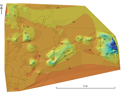
Fig. 2 The top of chalk below the Quaternary deposits, including chalk sheets dislocated by glacial tectonics. Contour lines with 10 m intervals shown above and below sea level.
The chalk is a white, greyish white or yellowish, soft, sludgy calcareous rock (Fig. 3), which almost exclusively consists of coccoliths, micrometre-sized plates from marine algae (coccospheres). Larger fossils of molluscs, bivalves, brachiopods, echinoids and siliceous sponges also occur. The chalk is commonly thoroughly bioturbated by benthic animals (Surlyk 1971, 2017; Surlyk & Håkansson 1999).
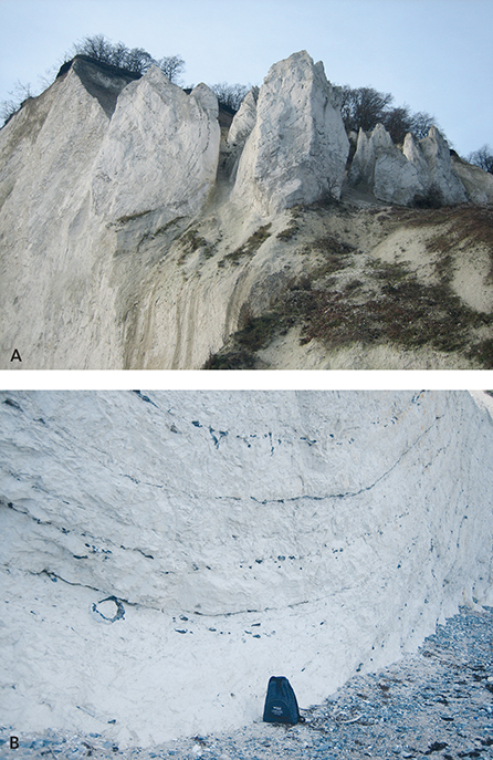
Fig. 3 Pale grey chalk with black flint layers. A: Folded flint layers in the chalk cliff of St. Stejlbjerg, southern Møns Klint. The chalk cliff is here almost 100 m high. B: Close-up of black flint layers in chalk. The large, circular flint concretion in the lower left of the photo is interpreted as formed around a Paramoudra burrow in the Cretaceous sea floor.
The chalk contains more or less coherent layers of black flint (Fig. 3; Madsen & Stemmerik 2010), which locally provide evidence that the chalk was deposited on shallow banks (Surlyk et al. 2006) in a sea that covered most of northern Europe, and where clastic sedimentation was almost absent (Fig. 4). However, thin cyclic deposits of marl occur in parts of the Maastrichtien. The Late Cretaceous chalk in eastern Denmark is divided into two formations: the Mandehoved Formation comprising two members (Campanien) and the Møns Klint Formation, which comprises five members and is named after the cliffs in the eastern part of Møn (Late Campanien – Maastrichtien; Surlyk et al. 2013). The division is based on investigations at Stevns Klint (Surlyk et al. 2006) and analyses from the c. 440 m Stevns-1 deep borehole (Fig. 5; Surlyk et al. 2013). The type profile itself comprises several of the five members. The age of the chalk has been determined by means of macro- and microfossils from the cliffs of Høje Møn and Hvideklint, which yield ages from Lower and Upper Maastrichtien (Surlyk 1984; Surlyk & Håkansson 1999; Thomsen 1995; Jelby et al. 2014).
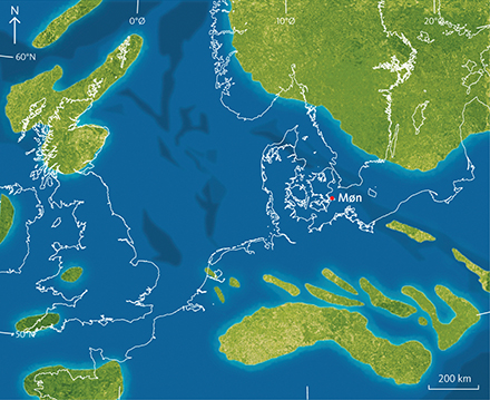
Fig. 4 Palaeogeographic map of the Late Cretaceous sea in Northern Europe. Green: land areas. Blue: sea. From Gravesen et al. (2017) after Damholt & Surlyk (2012).
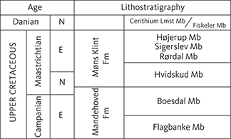
Fig. 5 Stratigraphic division of the uppermost Cretaceous and lowermost Danian in eastern Denmark (after Surlyk et al. 2006, 2013).
Glacial and interglacial deposits
Data and interpretation
A packet of glacial sediments up to 50–100 m thick rests on the pre-Quaternary surface. Most of them were deposited during the last part of the Weichselian glaciation c. 75 000–11 700 years ago. Few traces of older deposits from the Saalian glaciation (390 000–130 000 years ago) and the Eemian interglacial (130 000–115 000 years ago) are also present. On most of Møn, the glacial sediments have been deformed, folded and faulted by glaciotectonic processes, while large sheets of chalk have been pushed up from below the preQuaternary surface under Møn itself or surrounding areas, now covered by the sea (e.g. Berthelsen 1979; Pedersen 2000). Along with slide-sheets of chalk in tills and coherent chalk particles in the clastic deposits the dislocated chalk sheets can be considered part of the Quaternary deposits.
During the mapping, the following glacial deposits were differentiated: clayey till (ML), sandy till (MS) and gravelly till (MG). Add to these glaciofluvial gravel (DG), glaciofluvial sand (DS), glaciolacustrine silt (DI) and glaciolacustrine clay (DL) as well as late-glacial deposits: freshwater gravel (FG), freshwater sand (FS), freshwater clay (FL) and chalk (SK). A complete overview of the deposits and symbols can be found in Pedersen et al. (2015, appendiks 2).
The Quaternary stratigraphy is based on mapping, literature, data and studies of profiles on the southern, eastern and northern coasts of Møn and in a few gravel pits (Fig. 6A). In addition, the cross-sections shown on the geological map contribute much to the understanding of the glacial stratigraphy. A correlation at formation level using the cross-sections is shown in Fig. 25. Data from GEUS’ borehole data archive and Jupiter database have been used for the construction of these profiles (Gravesen & Fredericia 1984). A map of important geological localities on Møn is shown in Fig. 6B.
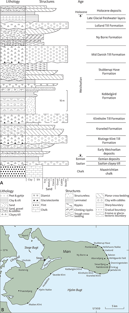
Fig. 6 A: Schematic stratigraphic log of the Quaternary interglacial, glacial and Holocene deposits occurring in the Møn map sheet area. B: Locations of geographic names with reference to geological type localities.
Older Quaternary deposits: Saalian, Eemian, Early and early Middle Weichselian (MIS 6, 5e, 5a–5d and 4)
A few scattered deposits of Saalian and Eemian age, Marine Isotope Stage (MIS) 6 age and even younger ages have been found in the cliffs (Fig. 6A), forming fragments and small, thin sheets in the strongly deformed glaciotectonic units. Despite being allochthonous, it is likely that deposits of this age have occurred in parts of Møn.
Saalian (MIS 6)
A single layer of clayey till beneath Eemian deposits at Kraneled and two similar beds at both Hellehavn Nakke og Stubberup Have are assumed to be of Saalian age (Fig. 8; Hyde 1986). Several other localities probably also contain Saalian clayey till, although the widespread glaciotectonic effects make this interpretation uncertain (Puggaard 1851; Hintze 1937; Hyde 1986; Houmark-Nielsen 1994). The clayey till layers are less than 3 m thick (Fig. 7) and are probably of Late Saalian (Warthe) age. The glaciotectonic deformation of both the Saalian and Eemian layers took place in the Middle or Late Weichselian (Berthelsen 1973; Aber 1979; Pedersen & Gravesen 2009; Houmark-Nielsen 2010).
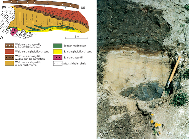
Fig. 7 Eemian deposits at Hjelm Nakke. A: Field sketch of the Saalian, Eemian and Weichselian deposits after Berthelsen et al. (1977). B: Clay and glaciofluvial sand (Saalian?) overlain by marine Eemian clay. Photo: Tove Stockmarr (1996).
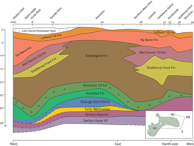
Fig. 8 Composite section showing the thicknesses and horizontal distribution of the lithostratigraphical units along the south, east and north coast cliffs of Møn based on selected vertical logs. The index map shows where the section changes orientation. Note different horizontal and vertical scales. Based on Houmark-Nielsen (2010) and Gravesen et al. (2017).
Eemian (MIS 5e)
In the Eemian Interglacial, Denmark was surrounded by sea. It is assumed that the Eemian sea covered parts of Møn (Seidenkrantz et al. 2000), although it is difficult to establish its precise extent because of the subsequent glaciotectonic disturbances. The presence of the Eemian sea has been documented from the North Sea, through the Danish straits and far into the Baltic Sea in the east, presumably with an Early Eemian connection through Karelen in Finland to the White Sea in the north-east (Knudsen et al. 2011). The Early Eemian Baltic transgression appears to have taken place from the east, with the oldest marine deposits in the Finnish Bay and the youngest in eastern Denmark, the Netherlands and Germany (Kristensen et al. 2000).
The dominant deposits on Møn are greenish to greenish black marine clay (Cyprina clay). Its thickness is locally up to c. 2 m (Fig. 7) but in most places only about 0.5 m. The glaciotectonic deformations make these estimates uncertain.
Marine fossils have been found in sand and clay deposits along the north coast of Møn at Øksnehøj/Orebjerg, Pomlerende and Stubberup Have and in several parts of Møns Klint, mainly in the falls but also along ridge flanks, e.g. at Hundevangsfald, Hvidskudsnakke, Lille Stejleberg, Store Stejlebjerg, Grårygfald, Fruerstuefald, Nælderende, Sandfaldet, Skrædderrenden, Maglevands-klinten/faldet, Dronningestolen, Vitmunds Nakke, Søndre Hylledalsklint, Taleren and Jydeleje Fald (Puggaard 1851; Madsen et al. 1908; Ødum 1933; Hintze 1937; Hansen & Nielsen 1960; Hyde 1986). Eemian deposits also occur at Kraneled Klint east of Klintholm on the south coast of Møn (Houmark-Nielsen 1994) and at two localities in the cliff between Hjelm Nakke and Hvideklint (Fig. 7; Berthelsen et al. 1977; Stockmarr 1996). In addition, gyttja and sand with freshwater molluscs and plant fossils from an interglacial period have been found under marine deposits, for example at Store Stejlebjerg (N. Hartz in Hintze 1937). This Eemian transition from freshwater to marine deposits is also known from other Baltic localities (Kristensen et al. 2000; Knudsen et al. 2011).
Macrofossils have been found in both sand and sticky clay. Marine molluscs in the clay have commonly been affected by glaciotectonic deformation, but nevertheless appear to remain in situ. The number of different species (Ødum 1933; Hintze 1937) is small compared to the extensive list of marine Eemian fossils listed in Madsen et al. (1908).
The lithology, age and fossil content of the fossiliferous deposits have been debated, but foraminiferal studies have demonstrated marine Eemian faunas at Hjelm Bugt, Kraneled and Pomlerende (V. Madsen in Hintze 1937; Berthelsen et al. 1977; J. Frederiksen in Hyde 1986; P. Kristensen in Houmark-Nielsen 1994); this supports the presence of marine macrofossils in these deposits. Local occurrences of sand and clay intercalated between layers of clayey till, which all contain Eemian foraminifera, show that these occurrences have been redeposited and that the beds are younger than Eemian (Konradi 1973).
The foraminifera in the Eemian deposits belong to a boreo-lusitanian, nearshore shallow-water fauna (Berthelsen et al. 1977), comparable to faunas from other localities in the western Baltic Sea and in the North Sea (Konradi 1976; Knudsen 1991). These species lived in sea water that was a little warmer and more saline than at present (Houmark-Nielsen 1994).
Age determinations of Eemian deposits from Klintholm–Kraneled by means of optically stimulated luminescence (OSL) and thermoluminescence (TL) have yielded considerably younger ages than expected (younger than 115 000 years before present (BP)). This discrepancy was discussed by Houmark-Nielsen (1994, 2008, 2010). Amino acid dating of selected molluscs (Arctica islandica, Turritella communis and Nassa reticulata from Klintholm, Arctica islandica and Turritella communis from Stubberup Have and Turritella communis from Hjelm Nakke (Petersen 1984; Miller & Mangerud 1985; Houmark-Nielsen 1994, 2008)) supports an Eemian age of the deposits from these cliff profiles.
Early and early Middle Weichselian (MIS 5a5 d, MIS 4)
In Early and early Middle Weichselian, Møn was probably ice-free, with surface conditions dominated by solifluction and limited fluvial transport and deposition. Redeposited Eemian macrofossils occur in deposits from this period (Houmark-Nielsen 1994), which have estimated thicknesses of 2–20 m.
Middle and Late Weichselian (MIS 3, 2)
The most widespread glacial units in the map area were deposited in Middle Weichselian (74 000–29 000 years ago) during the last part of the latest ice age and in Late Weichselian (29 000 to c. 11 700 years ago, Fig. 6A), but only parts of these time intervals are represented.
Because of the extensive glaciotectonic disturbance of the Quaternary deposits on Møn, it is difficult to make appropriate formal descriptions of existing lithostratigraphic units, establish new ones and document their extent, despite good exposure. Nevertheless, a number of geological cliff profiles with descriptions of the lithologies and interpretations of their formation have been published in recent years, for example by Houmark-Nielsen (1994) and Gravesen et al. (2017) in reports and unpublished MSc theses. In addition, hydrogeological mapping (Rambøll 2006, 2007) has contributed to the present understanding of the three-dimensional geological structure in the interior parts of Møn where there are few outcrops. This information, combined with the systematic surface mapping, profiles in gravel pits, information from boreholes and geophysical data, has contributed to the establishment of new and revisions of existing Middle and Late Weichselian geological formations presented in the following. All quoted ages are based on Houmark-Nielsen et al. (2017).
A profile along southern, eastern and north-eastern Møn has been constructed from selected logs (Fig. 8). The profile begins at Madses Klint in the south, follows the south-eastern and eastern coasts with Møns Klint, continues towards north-east to Hellehavn Nakke and terminates on the north coast at Brunshoved. The profile illustrates the overall lithostratigrafic structure and the horizontal and vertical extent of each unit. The different units and their formal division into formations are described below.
Ristinge Klint Till Formation (MIS 3)
Name and history. The formation is named after Ristinge Klint on Langeland, a classical locality which has contributed to the general understanding of the geological structure of Denmark (Madsen et al. 1908; Madsen 1916). Andersen (1945) and Berthelsen (1973) called the till unit the “Gammel Baltiske Till” (old Baltic till). Houmark-Nielsen (1987) formally erected the Ristinge Klint Till Formation and presented a detailed description of its history of formation. He showed that the deposition of the till, which contains fine-grained gravel with a Baltic provenance, was related to an ice advance from south-east (Sjørring et al. 1982). On Møn, Houmark-Nielsen (1994) called the formation “Grey-red till, Unit 4” at Klintholm.
Type locality. Ristinge Klint on Langeland (Houmark-Nielsen 1987).
Lithology. The formation consists of grey to reddish grey till. The reddish colour is due to a high content of Lower Palaeozoic Baltic sandstone and limestone. The lower part of the formation consists commonly of layered, grey to whitish till with a high content of fragmented, sheared and folded chalk and smeared out by glaciotectonic deformation, a glacitectonite (Fig. 9; Banham 1977; Pedersen 1988). The upper part of the till is reddish grey with reddish sand and sandstone, which can be commonly found on the beach below the cliffs. Fine-grained gravel and clasts are dominated by Baltic material (Berthelsen et al. 1977; Hyde 1986; Houmark-Nielsen 1994; Stockmarr 1996; Smed 2010). Redeposited Eemian material occurs locally. In the cliff profiles of north-eastern Møn, till fabric measurements show a poorly defined easterly orientation with a shallow to moderate easterly plunge (50 measurements in Hyde 1986). Disregarding the fact that the till has also been affected by subsequent glaciotectonic dislocation in this area, these measurements show a well-defined ice movement from east to west. This provenance is supported by indicator counts of fine gravel showing 25% limestone (of which two thirds are Palaeozoic), a low content of flint (<5%) and up to 15% sedimentary gravel, mainly consisting of sandstone (Hyde 1986). Lithological symbols: ML, MS.
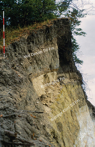
Fig. 9 Red-brown clayey till of the Ristinge Klint Till Formation at Store Stejlebjerg, Møns Klint. The formation rests unconformably on top of the Cretaceous chalk of the Møns Klint Formation. Fine-grained lithologies of the Kobbelgård Formation overlie the Ristinge Klint Till Formation. At the top, clayey till of the Mid Danish Till Formation is present. For scale, the units on the ranging pole are 20 cm wide.
Boundaries and thickness. At Klintholm, the lower boundary of the formation is a glaciotectonic unconformity above older, presumably Early or early Middle Weichselian deposits. At Hvideklint and Hjelm Nakke, the formation commonly rests on chalk. The upper boundary against the Kraneled Formation is sedimentary and erosive.
The thickness of the formation is probably a few metres at Hvideklint – Hjelm Nakke, 4 m at Klinthavn, 1 m at Høje Møn, 3 m at Hellehavn Nakke and 2 m at Pomlerende (Hyde 1986; Houmark-Nielsen 1994; Stockmarr 1996).
Extent and correlation. The formation occurs at a number of different localities, for instance Hjelm Nakke – Hvideklint (probable), Høje Møn, Klintholm, Hellehavn Nakke and Pomlerende. This indicates that the formation previously had a larger extent in southern and eastern Møn, and it probably exists in large parts of Denmark (Houmark-Nielsen 1987, 2007).
Age. The formation was deposited as part of the Ristinge Ice Advance between 55 000 and 50 000 years ago (Houmark-Nielsen 2010; Houmark-Nielsen et al. 2017).
Depositional environment. The till is a lodgement till. Its content of Baltic fine-grained gravel and clasts and the glaciotectonic structures show that the glacier movement was from south-east towards north-west (Houmark-Nielsen 1999; Smed 2010), called the Ristinge Ice Advance (Houmark-Nielsen 1987; Houmark-Nielsen et al. 2017).
Kraneled Formation (MIS 3)
New formation
Name and history. The Kraneled Formation is named after the locality of Kraneled east of Klintholm on southern Møn (Fig. 6B). Houmark-Nielsen (1994) described it as “Glaciofluvial and lacustrine deposits, Unit 5”, while it was called “Klintholm Beds” in Houmark-Nielsen & Kjær (2003) and “Klintholm” in Houmark-Nielsen et al. (2017).
Type locality and type profile. The type locality is Kraneled Klint east of Klintholm (Fig. 10; Houmark-Nielsen 1988, 1994). The type profile is shown in Houmark-Nielsen (1994, fig. 5, unit 5).
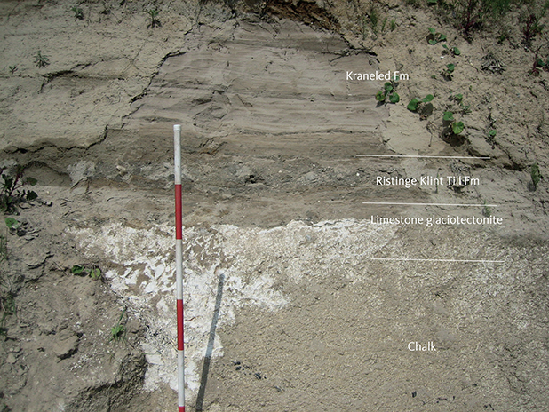
Fig. 10 Fine-grained meltwater deposits of the Kraneled Formation resting on the Ristinge Klint Till Formation. Between the till and the underlying chalk, a chalk-glacitectonite occurs. Kraneled cliff, Klintholm.
Lithology. The lower part of the formation consists of cross-bedded and imbricated sand and gravel. The upper part is cross-bedded sand changing upwards into fine-grained sand and horizontally laminated clay (Fig. 10). A few plant remains may be present. Lithological symbols: DL, DS, DG.
Boundaries and thickness. The lower boundary against the Ristinge Klint Till Formation is sharp and erosional. The upper boundary is a gradual sedimentary transition to the Klintholm Till Formation.
The thickness of the formation is around 4 m at Klintholm and 2 m at Tøvelde Klint, but larger in western Møn, about 7 m in wells.
Extent and correlation. Because of poor exposure, it is difficult to establish the lateral extent of the formation. It occurs along Hjelm Bugt and on western Møn.
Drilling investigations at Kriegers Flak in the Baltic Sea east of Møn document the presence of interstadial lacustrine deposits 40 000–35 000 years ago, which probably correspond to the Kraneled Formation (Anjar et al. 2010, 2012). Deposits of the same age occur within the large ice-dammed lake area at Brorfelde on Sjælland, where mammoth tusks have been found in thick sandy deposits dated at 44 000 BP (Selsing 1982).
Interstadial deposits on Sejerø west of Sjælland have been dated to c. 36 000 years ago, i.e. prior to the deposition of the Klintholm Till Formation and probably contemporaneous with the Kraneled Formation deposits. The plant content in the lacustrine deposits on Sejerø indicate an open, treeless area with tundra vegetation (Kolstrup & Houmark-Nielsen 1991; Bennike et al. 2007). The fine-grained part of the Kraneled Formation may represent the same depositional environment as on Møn during the Sandnæs Interstadial period.
Age. The formation has an age of c. 45 000–35 000 BP (Houmark-Nielsen et al. 2017) and was therefore probably formed during the first phase of the Sandnæs Interstadial.
Depositional environment. The lowermost, coarse-grained glaciofluvial material was probably deposited in a meltwater river in a periglacial area. The overlying deposits point to lacustrine deposition. The landscape was presumably open, with sparse Arctic tundra vegetation.
Klintholm Till Formation (MIS 3)
Revised formation
Name and history. The formation is named after the small town of Klintholm on the south coast of Møn. It has been described by Houmark-Nielsen (1994) as “Thick grey diamicton” and by Krüger og Kjær (1999) as “Unit 6”. The till deposit has subsequently been described as “Klintholm Till” (Houmark-Nielsen & Kjær 2003; Houmark-Nielsen 2008, 2010; Houmark-Nielsen et al. 2016).
Type locality and type profile. Kraneled east of Klintholm. A reference profile is found at Kobbelgård west of Klintholm (Fig. 11; Houmark-Nielsen 1988, 1994, fig. 5, unit 6).
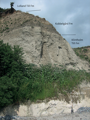
Fig. 11 Grey clayey till of the Klintholm Till Formation at Kraneled cliff, Klintholm. The section also contains deposits of chalk as well as deposits of the Ristinge Klint Till, Kobbelgård and Lolland Till Formations.
Lithology. The Klintholm Till Formation consists of massive, silty and sandy till with a moderate clast content (Figs 6, 11). In its uppermost part dark brown, massive and locally stratified clayey till may occur. Redeposited shells and shell fragments of marine Eemian molluscs may also occur. Lithological symbols: ML, MS.
Boundaries and thickness. The thickness of the formation is c. 2.6 m at Madses Klint, 3.6 m at Hjelm Nakke – Hvideklint, 4 m at Tøvelde Klint, 3–5 m at Klintholm, 3 m at Møns Klint, c. 1.5 m at Hellehavn Nakke and 1.8 m at Stubberup Have (Hyde 1986; Houmark-Nielsen 1994; Stockmarr 1996; Gravesen et al. 2017).
The lower boundary of the Klintholm Till Formation is mostly a gradual transition from clayey till downwards to sand and mud of the Kraneled Formation, but locally, may also be a glaciotectonic unconformity. The upper boundary is gradational from clayey till to mud of the Kobbelgård Formation.
Extent and correlation. The Klintholm Till Formation has a wide extent from Møn to Falster (Korselitse) and southern Sjælland (Houmark-Nielsen 2010).
Age. The Klintholm Till Formation was laid down during the Klintholm Ice Advance, dated at c. 35 000–32 000 BP (Houmark-Nielsen 2010; Houmark-Nielsen et al. 2017).
Depositional environment. The formation is interpreted as a lodgement till deposited by a glacier with a general movement from south-east towards north-west. This can be demonstrated by the content of indicator erratics of fine gravel, clast fabric orientations and glaciotectonic structures. Smed (2010) counted and analysed clasts and showed that a part of the glacier movement was first from north-east to south-west through Sweden, and then changed to a westerly direction towards Denmark (see also Ukkonen et al. 2007). The ice advance was called the “Klintholm Isstrøm” by Houmark-Nielsen et al. (2017).
Kobbelgård Formation (MIS 3)
New formation
Name and history. The Kobbelgård Formation is named after the cliff at Kobbelgård, Hjelm Bugt, southern Møn, where interstadial lacustrine, glacial lacustrine and glacial fluvial deposits occur. The deposits have been studied particularly well near Klintholm Havn in the two cliffs at Kobbelgård and Kraneled (Houmark-Nielsen 1988, 1994, 2003, 2010; Krüger & Kjær 1999; Houmark-Nielsen et al. 2016), where a sequence that also comprises the Klintholm Till and Kraneled Formations (Fig. 8) has been described in detail and interpreted based on age determinations, sedimentology and the content of plant and animal fossils.
The lower part of the clayey deposits is known from previous investigations on Møn (e.g. Puggaard 1851; Hintze 1937; Hansen & Nielsen 1960; Berthelsen et al. 1977) and described as a clay deposit with minor clast content (“Stenfattigt ler”, Hyde 1986). A characteristic vertical joint pattern (“søjleforkløftning”, Berthelsen et al. 1977) has led to the informal name elephant-foot clay because eroded and commonly folded exposures may resemble elephant feet. At Klintholm, the layers have been described by Houmark-Nielsen (1994) as “Lower lake sediments, Unit 7” as a part of “Upper Kobbelgård Beds” by Houmark-Nielsen et al. (2016).
The upper part of the formation mainly comprises the fossil-rich part of the lacustrine deposits at Klintholm, which consist of clay, silt and diamict deposits. They have been described as “Upper lake sediments, Unit 8”, by Houmark-Nielsen (1994) and “Upper Kobbelgård beds” or “Kobbelgård Beds” (Houmark-Nielsen & Kjær 2003; Houmark-Nielsen 2010). They have also been described by Krüger & Kjær (1999).
Type locality and type profile. The type locality for the Kobbelgård Formation is Kobbelgård Klint and Kraneled Klint, west and east of Klintholm Havn, respectively, where several partial profiles have been measured (see Houmark-Nielsen 1994 fig. 5, unit 7, unit 8; Houmark-Nielsen 1988, 1994; Krüger & Kjær 1999).
Lithology. The lowest part of the formation consists of clay/mud with thin sandy layers and many dispersed clasts (Fig. 12). The clayey deposit contains numerous joints. Cross-bedded and horizontally bedded sand occurs locally at the base of the formation, in places with redeposited shells derived from Eemian deposits.
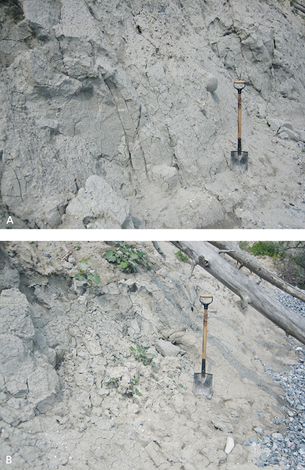
Fig. 12 Lacustrine deposits of grey, silty clay with scattered pebbles of the Kobbelgård Formation. A: Typical glaciolacustrine clay with widely spaced dropstones. B: Clay at Liselund in the dislocation horizon at the toe of a landslide.
The clay is sticky and silty, calcareous and dark grey, with thin layers of sand and commonly dispersed clasts. The content of clay and silt is 90–94%; the remainder is sand and fine-grained gravel, the latter almost entirely consisting of Palaeozoic limestone (Hyde 1986). Apart from joint systems, the only visible structure is indistinct layering in the clayey part, which is difficult to discern. Scattered plant remains consist of leaves and detrital plant material, as well as pollen from an Arctic flora (Kolstrup & Houmark-Nielsen 1991).
The upper part of the formation consists of a number of alternating layers of massive clay and silt as well as discontinuous layers of fine sand with intercalations of clayey diamictites towards the top (Fig. 13). Plant remains including leaves and fine-grained detritus also occur, and an extensive micro- og macroflora has been described (Kolstrup & Houmark-Nielsen 1991; Bennike et al. 1994, 2007). Clasts and fine gravel in the diamict deposits are dominated by Palaeozoic limestone and shale, but the uppermost layers contain a mixture of local material and rock fragments from the Baltic area. Lithological symbols: DL, DI, DS, ML.
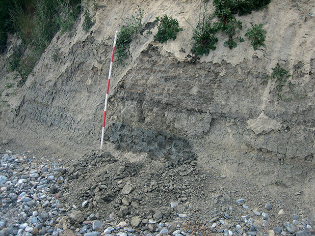
Fig. 13 Grey, silty and fine-grained, horizontally laminated clay of the Kobbelgård Formation. Kobbelgård cliff, Klintholm. For scale, the units on the ranging pole are 20 cm wide.
Boundaries and thickness. The lower boundary towards the Klintholm Till Formation is commonly gradational. The upper boundary to the Mid Danish Till Formation is a glaciotectonic unconformity. The thickness of the Kobbelgård Formation reaches up to 15 m at Klintholm but varies at other localities, with approximate values as follows: Madses Klint: 7.5 m, Hjelm Nakke – Hvideklint: 12.5 m, Tøvelde Klint: 7.5 m, Møns Klint: 12 m, Liselund: 5 m, Hellehavn Nakke: 11 m and Stubberup Have: 7 m (Ødum 1933; Hintze 1937; Hyde 1986; Houmark-Nielsen 1988, 1994; Stockmarr 1996; Houmark-Nielsen et al. 2016; Gravesen et al. 2017).
Extent and correlation. The formation has a wide extent on southern, eastern and north-eastern Møn. The upper part, rich in fossils, is mainly encountered on the south coast. Parts of the formation are probably contemporaneous with deposits on Kriegers Flak (Anjar et al. 2010, 2012). The formation is also exposed along the east coast of Falster, for example at Korselitse (Houmark-Nielsen 2010; Gravesen et al. 2017).
Age. The deposits are from the Middle Weichselian, MIS 3. The formation rests on the Klintholm Till Formation, which has an age of 35 000–32 000 BP (Houmark-Nielsen et al. 2017).
A number of 14C, OSL and TL age determinations on plant material and sediments from the Kobbelgård Formation have yielded ages spreading through the last part of the Middle Weichselian, with ages of 35 000–20 000 years using the OSL method and 37 000–25 000 using the 14C method (Houmark-Nielsen 2010).
Collectively, the age determinations from Klintholm indicate that the most likely age is between 32 000 and 28 000 BP (Houmark-Nielsen & Kjær 2003; Houmark-Nielsen 2008, 2010; Houmark-Nielsen et al. 2016, 2017). The age of the formation is 32 000–28 000 BP, representing deposition during the last part of the Sandnæs interstadal (Sandnæs Mildningen, Houmark-Nielsen et al. 2017).
Depositional environment. At the end of the cold period, about 32 000 years ago, when the ice of the Klintholm Ice Advance melted away, a large glacial lake was formed, which covered all of southern, eastern and northern Møn and possibly also an even larger Baltic area, as suggested by Hansen (1965) and Houmark-Nielsen (1994). Sand and gravel were deposited first, where meltwater entered the lake. Widespread deposition of clay and silt followed, and ice rafts transported clasts into the lake, which were deposited as dropstones. Fine sand was blown out over the lake from the barren surrounding landscape and deposited as thin strata. As the climate became warmer and less meltwater was supplied from the Baltic ice, the size of the lake diminished, and an Arctic vegetation with grasses herbs and a few small trees like Pinus and Betula was established around the lake.
From 30 000 to 28 000 BP, the lake was probably restricted to an area around Klintholm. Mud (clay, silt and fine sand) was deposited from suspension, while diamictites were deposited from mud streams and/or ice rafts. Also, fine aeolian sand and silt deposits have been documented (Houmark-Nielsen 1994; Krüger & Kjær 1999). The vegetation around the lake was subarctic with many herbs and shrubs, but treeless. The increasingly warmer subarctic climate led to increasing vegetation in and around the lake. Lateral cross-bedded, fine-grained dunes were laid down by adjacent river systems, which also carried sand and gravel out into the lake (the Stubberup Have Formation).
A mammoth tooth found at Slotshøj, Stege Nor (Aaris-Sørensen et al. 1990) may indicate the former presence of a large grassy area around the lake. At this time, large grassy and herbaceous plains with mammoths and other large animals have been present in Denmark (Aaris-Sørensen et al. 1990) and southern Sweden (Berglund et al. 1976; Ukkonen et al. 2007).
Stubberup Have Formation (MIS 3)
New formation
Name and history. Named after the northern part of Møns Klint in the area around Stubberup Have.
Type locality and type profile. Stubberup Have (Fig. 14; Hyde 1986).
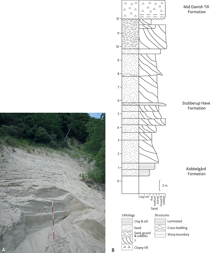
Fig. 14 A: Medium- and coarse-grained, cross-bedded sand of the Stubberup Have Formation at the cliff of Stubberup Have, the type locality for the formation. The units on the ranging pole are 20 cm wide. B: Sedimentological log of the Stubberup Have Formation.
Lithology. The formation consists of sand, gravel and occasionally stones (Figs 8, 14). Sedimentary structures comprise ripples, horizontal bedding, large-scale cross-bedding and coarse-grained channel structures with gravel and stones, which have incised into the underlying layers of sand. Fine-grained, well sorted sand and silt with climbing ripples are also encountered.
Boundaries and thickness. The thickness of the Stubberup Have Formation is quite variable (Fig. 8), with the following observations: Madses Klint: 1.3 m, Hjelm Nakke – Hvideklint: 4.5 m, Tøvelde Klint: 5 m, Møns Klint: 1.4 m, Liselund: 10 m, Hellehavn Nakke: 11 m and Pomlerende: at least 3 m (Hintze 1937; Hyde 1986; Stockmarr 1996; Gravesen et al. 2017). A few boreholes point to thicknesses of up to 20 m, but the layers may have been disturbed by glaciotectonics.
The formation has a sharp lower depositional boundary against the Kobbelgård Formation (Fig. 8). Towards west from the Tøvelde and Klintholm cliffs towards Madses Klint, the boundary is probably interdigitating. The upper boundary against the Mid Danish Till Formation is a sharp glaciotectonic unconformity.
Extent and correlation. The Stubberup Have Formation is found in large parts of Møn.
Age. The age of the Stubberup Have Formation is likely the same age as the Kobbelgård Formation (32 000–28 000 BP; Houmark-Nielsen et al. 2017).
Depositional environment. The depositional environment was a plain with braided rivers, which formed small ripples and larger dunes. Lacustrine conditions locally prevailed, and the deposition of silt and fine-grained sand as climbing ripples suggests a large sediment supply.
Mid Danish Till Formation (MIS 2)
Name and history. The Mid Danish Till Formation was established by Houmark-Nielsen (1987) for the lithological till unit that extends from the eastern boundary of Denmark to the Eastern Jutland stationary line. At the type locality of Ristinge Klint on Langeland, the formation forms a homogenous lithological unit about 15 m thick within the imbricated sheets that comprise the glaciotectonic complex of Ristinge Klint. The geological basis for the establishment of the formation can be found in Houmark-Nielsen (1987).
Type locality and type profile. Ristinge Klint on Langeland (Houmark-Nielsen 1987). The reference profile on Møn is at Madses Klint (Fig. 15).
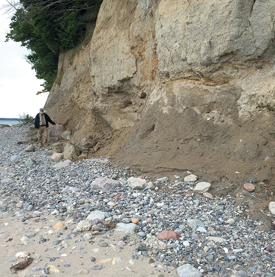
Fig. 15 Grey clayey till of the Mid Danish Till Formation, Madses Klint.
Lithology. The formation consists of massive, calcareous till, commonly with a high content of chalk clasts. Where the till has been affected by glaciotectonic shear, the chalk erratics may be classified as “glacitectonite” (Pedersen et al. 2018). Lithological symbol: ML.
Boundaries and thickness. The formation has a sharp contact against the underlying Stubberup Have Formation, usually a glaciotectonic unconformity (Fig. 6). It is overlain by the Ny Borre Formation with a sharp depositional boundary.
On Møn, the thickness of the Mid Danish Till Formation is very variable but may reach a thickness of up to 10 m. The following thicknesses have been observed: Madses Klint: 3.5 m, Hjelm Nakke – Hvideklint: 6 m, Tøvelde: 4 m, Møns Klint: 9 m, Liselund: 3 m, Pomlerende: variable thicknesses, Stubberup Have: 5.5 m and Brunshoved: 8 m. (Ødum 1933; Hansen & Nielsen 1960; Berthelsen et al. 1977; Hyde 1986; Stockmarr 1996; Gravesen et al. 2017).
Extent and correlation. The Mid Danish Till Formation covers all of Møn except the Klintholm area.
Age. The age of the formation is c. 23 000–20 000 BP (Houmark-Nielsen et al. 2017) and it was deposited during the Late Glacial Maximum (LGM) of the Weichselian glaciation.
Depositional environment. The Mid Danish Till Formation is a lodgement till deposited by a glacier. Glaciotectonic orientation parameters, clast content and indicator counts of fine gravel show that the glacier moved from north-east towards south-west (Berthelsen et al. 1977; Aber 1979; Hyde 1986; Stockmarr 1996; Smed 2010).
The formation was deposited during the maximal extent of the Scandinavian ice cap in the last part of the Weichselian glaciation. The main stationary line for this ice advance was located 100 km south and west of Møn, stretching from Flensburg and north of Hamburg to Brandenburg and then turning south of Berlin and into northern Poland, the so-called maximum Brandenburg ice-marginal stationary line (Smed & Ehlers 2002; Ehlers et al. 2004).
Ny Borre Formation (MIS 2)
New formation
Name and history. The formation is named after the village of Ny Borre south of Borre on eastern Møn. It includes the surficial glaciofluvial and glaciolacustrine deposits of sand and gravel that occur in large parts of Møn. These deposits have not previously been formally named. Sand and gravel from the Ny Borre Formation are excavated, for example, in the Ny Borre gravel pit.
Type locality and type profile. The type locality is in the active gravel pit at Ny Borre. The type profile is shown in Fig. 16, a layered sandy sequence comprising both coarse- and fine-grained deposits.
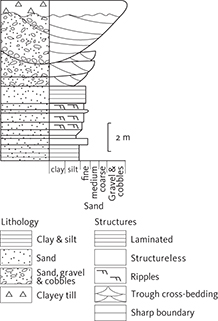
Fig. 16 Sedimentological log of the fluvial–lacustrine sequence of the Ny Borre Formation at the type locality in the Ny Borre gravel pit.
Lithology. The formation consists of layered silt, sand and gravel. The coarse-grained sand is found in many places on Møn. The grain size is variable, depending on the local depositional environment. The lower part consists of alternating layers of fine- to medium-grained sand and silt as well as lenses of coarse-grained sand and occasional layers of clay. The layers are inclined locally and may be part of channel deposits of larger foresets, which point to a current direction from south and southwest (Fig. 17). The upper and more widespread part consists of cross-bedded, coarse sand, intercalated with gravel in larger channel structures. Lithological symbols: DS, DG, DI, FS, FG.
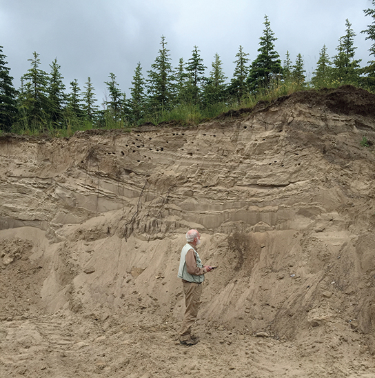
Fig. 17 Inclined, alternating silt, sand and gravel layers in a lacustrine sequence of the Ny Borre Formation. Ny Borre gravel pit.
Boundaries and thickness. The lower formation boundary against the Mid Danish Till Formation is sharp and mainly depositional. The lower and upper boundaries can be observed at the same localities.
The upper boundary against the Lolland Till Formation is also sharp and commonly a glaciotectonic unconformity. It can be observed in a number of coastal cliffs, for example Madses Klint, Hjelm Nakke, Hvideklint, Tøvelde, Møns Klint and in the cliffs north of Høje Møn (Liselund, Stubberup Have and Pomlerende). The thickness of the formation is 5–10 m in large parts of the island but may be greater in the large channels. At the type locality of the Ny Borre gravel pit, the thickness is c. 6 m (Storstrøms amt 2004; Region Sjælland 2012). The thickness variation in the cliffs, where the formation is overlain by the Lolland Till Formation, is as follows: Madses Klint: 12 m, Hvideklint: 6 m, Tøvelde: 1.5 m, Møns Klint: 5.5 m, Liselund: at least 4.5 m, Pomlerende: up to 3 m and Stubberup Have: 5.5 m (Hintze 1937; Hyde 1986 ; Stockmarr 1996).
Extent and correlation. The formation extends over large parts of Møn and is shown on the geological map as a surficial deposit or immediately under the Lolland Till Formation. This is also observed in Rambøll (2006). Here, its extent follows a number of valleys, from north to south comprising Borre Sømose, Maglemose, Klostervig and the lowland bordering Stege Nor, the Røddinge lowland and Fanefjord, which are all tunnel valleys or draining channels from the melting Young Baltic Ice. The esker of Råbylille Ås is located in a supposed tunnel valley extending from Kobbelgård to Stege Nor. The esker of Fanefjord Ås is found in the Fanefjord tunnel valley (Smed 2014). A variety of the Ny Borre Formation sediments is found in both of these tunnel valleys, as well as in hat-shaped hills in south-western Møn (Berthelsen 1980).
Age. The Ny Borre Formation is regarded as having been deposited during the Young Baltic Ice Advance, presumably 19 000–18 000 BP (Houmark-Nielsen et al. 2017).
Depositional environment. The formation represents several successive depositional environments formed by meltwater from the Young Baltic Ice: a glaciofluvial environment where sand and gravel were deposited on valley sandurs, which developed in a number of large draining channels eroded into the Mid Danish Till Formation, and a glaciolacustrine environment with deposition in variably ice-dammed elongate lakes perpendicular to the ice margin. Layers of sand and gravel were also deposited in near-surface eskers and hat-shaped hills.
Lolland Till Formation (MIS 2)
Name and history. The Lolland Till Formation is named after Lolland in south-eastern Denmark and was established by Pedersen et al. (2015) in the Sakskøbing map sheet description. The till that covers the landscapes of south-eastern Denmark are traditionally assigned to the lodgement till deposited by the Young Baltic Ice Advance. In the southern and central parts of eastern Jylland, the till is called the East Jylland Till Formation (Houmark-Nielsen 1987), while lodgements from the subsequent glacial re-advance, which completed the ice cover of Denmark, are called the Bælthav Till Formation.
Type locality and reference profile. The type locality of the Lolland Till Formation is the Birket gravel pit on Lolland (Pedersen et al. 2015). On Møn, there is a reference profile at Kobbelgård (Fig. 18; Houmark-Nielsen 1994).
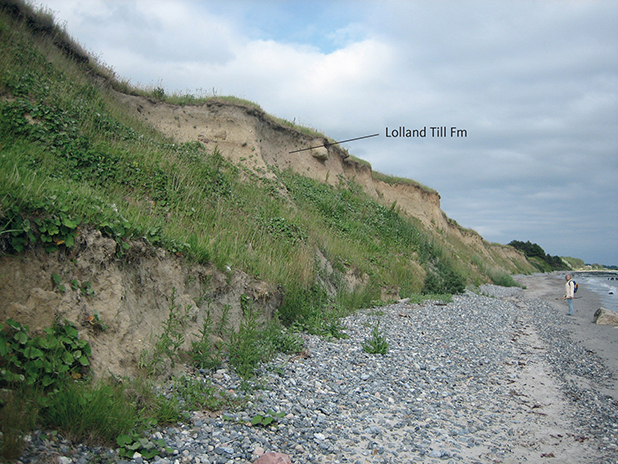
Fig. 18 Greyish brown clayey till of the Lolland Till Formation in the uppermost part of the cliff at Kraneled, Klintholm.
Together with the Ny Borre Formation, the Lolland Till Formation forms the predominant surficial lithology of Møn, comprising 80% of the land area. Access to exposures through the formation can be difficult as the till forms the uppermost part of the relatively high coastal profiles. Here the formation is seen to be draped over all other lithologies, and in several of the profiles it rests unconformably on older deposits, disturbed by glaciotectonic processes.
Lithology. The formation consists of silty, brown to yellowish brown till (Fig. 19). The lithology is commonly massive and compact but may also contain a weak horizontal stratification. The clast content is relatively low, although a few clasts of chalk are present (Houmark-Nielsen 1994; Smed 2010; Gravesen et al. 2017). Till layers with a very high content of chalk may be classified as chalk-glacitectonite (Banham 1977; Pedersen 1988), as described in Pedersen et al. (2018). Counts of indicator erratics of fine gravel from several localities (Hyde 1986; Houmark-Nielsen 1994) show that Palaeozoic carbonate grains are more common than Cretaceous ones. Lithological symbols: ML, MS.
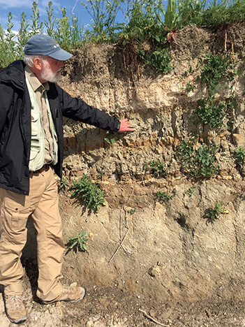
Fig. 19 Grey-brown, clayey till of the Lolland Till Formation below Late Weichselian freshwater deposits at Tøvelde Klint. At the top of the lacustrine succession a calcareous gyttja is seen.
Boundaries and thickness. The lower boundary is the glaciotectonic unconformity at the base of the formation. The formation mostly rests on the Ny Borre Formation, except in the Klintholm area where it rests on the Kobbelgård Formation (Fig. 8). In large parts of Møn, the upper boundary is also the terrain surface. However, it is overlain by Late Weichselian freshwater deposits, for example at Tøvelde Klint and Hjelm Nakke, and locally by Holocene marine deposits. In both cases the boundaries are sharp.
The thickness is generally 1–3 m. Borehole data suggest it may be thicker, although potentially affected by glacial tectonic disturbance. In the cliffs, the following thicknesses have been measured: Madses Klint: 2 m, Hvideklint: 2 m, Tøvelde Klint: 2.8 m, Klintholm: 0.8 m, northern Møns Klint: 0.8 m, Stubberup Have: 2 m, Liselund: 1.5 m, Pomlerende; 0–2 m, Hellehavn Nakke: 2 m and Brunshoved: at least 2 m (Hyde 1986; Gravesen et al. 2017). Thin strata from the formation have also been found in the hat-shaped hill of Præstebjerg on southwestern Møn (Berthelsen 1980). The formation is absent from the highest part of Møns Klint.
Extent and correlation. The Lolland Till Formation extends over the entire area of Lolland, Falster and Møn and on the islands of the strait of Smålandsfarvandet.
Age. The Lolland Till Formation has an age of 18 000– 17 000 BP (Noe-Nygaard et al. 2017).
Depositional environment. The melting of the NorthEastern Ice left Møn, Falster, Lolland and the strait of Smålandsfarvandet as a hummocky moraine plateau. This was subsequently covered by the Young Baltic Ice Advance, which spread from the north-eastern Baltic Sea towards west.
Analyses of clast fabrics and glaciotectonic deformation combined with a high content of Palaeozoic limestone show that the till was deposited by a glacier moving from south-east towards north-west (Hyde 1986).
While the Young Baltic Ice was advancing, its frontal part was spread out with movements towards its margins, with an advance towards central Denmark on its northern flank and towards northern Germany on its southern flank. On Lolland, this meant that the initially E–W-oriented ice stream was turned counterclockwise into a NW-directed flow. Finally, the flow direction was rotated still further towards NNW The NW- and NNWdirected ice advance stopped at the Eastern Jutland Stationary Line in the central part of Djursland, where the meltback resulted in the extramarginal outwash plain of Tirstrup Hedeslette (Pedersen & Petersen 1997). From here, the ice melted back with oscillatory movements, which resulted in the Bælthav Ice Advances, where a series of stationary lines have been mapped (Milthers 1948). On Møn, this resulted in till deposition, while the Lolland Till Formation was split into two till units separated by a thin layer of meltwater sand in parts of Lolland and Falster.
Late Weichselian (Late Glacial, MIS 2)
Deposits from the last part of Late Weichselian (Senglacial) are mainly known from Hjelm and Tøvelde on the south coast of Møn, where freshwater deposits comprise large parts of the Late Glacial period between 17 000 and 11 700 BP: Oldest Dryas, Bølling, Older Dryas, Allerød and Younger Dryas (Kolstrup 1982; Noe-Nygaard & Heiberg 2001). Tøvelde, which is one of the best investigated localities, comprises an almost complete Late Glacial profile (Fig. 20).
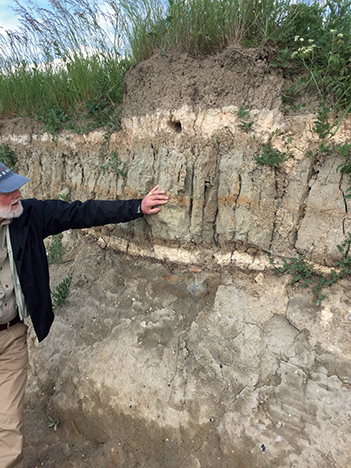
Fig. 20 Late Weichselian – Holocene lacustrine deposits at Tøvelde, formed in a shallow depression of the till of the Young Baltic Ice Advance.
Late Glacial freshwater deposits have also been found in bogs on Høje Møn (Hintze 1937), whereas no marine deposits are known from this period on Møn. At Madses Klint, there are layers of calcareous gyttja and peat on top of the Young Baltic Lolland Till Formation. These layers may be either late glacial or postglacial in age but have not been dated (Fig. 21). Late Glacial deposits also occur at the base of the Borre Sømose profile (Mikkelsen 1949). The freshwater sediments mainly consist of clay (TL), silt (TI), gyttja (TP), peat (TT), sand (TS), gravel (TG) and variegated layers (TV).
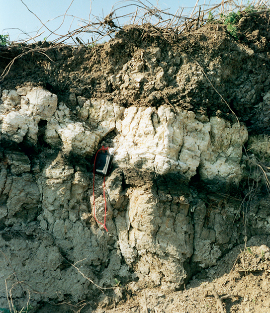
Fig. 21 The Late Weichselian freshwater deposits high up in the section at Madses Klint, which contains a bed of 20 cm thick calcareous gyttja. Photo: Tove Stockmarr.
The deposits at Tøvelde are well exposed along c. 100 m in the coastal cliff at Tøveldestenen (the Tøvelde boulder) and comprise several small lake basins, which gradually developed into a larger lake. The exposure at Hjelm is more restricted, located high up in the coastal profile and difficult to access (Heiberg 1991). The lake basins of these two well-described localities show an extensive freshwater fauna and flora as well as terrestrial animals from around the lakes (Johansen 1904; Heiberg og Bennike 1997; Noe-Nygaard & Heiberg 2001). The fauna comprises terrestrial rodents, amphibians, snails, bivalves and insects as well as freshwater fish, snails, bivalves and insects. The deposits are collectively up to 3.8 m thick.
Deposits in several bogs on Høje Møn have also been studied (Hintze 1926, K. Jessen in Hintze 1937). In some of them, a Late Weichselian freshwater sequence of clay from Older Dryas, gyttja from Allerød and clay from the Younger Dryas have been found, overlain by Holocene deposits.
Late Weichselian development (Late Glacial)
In the late Weichselian, at about 16 000 BP, a large icedammed Baltic meltwater lake, the Baltic Ice Lake was formed. On Møn, a variable deposition of mainly peat and gyttja took place in the smaller lake depressions at Hjelm og Tøvelde. The lake basins were formed in an elevated area by the melting of isolated ice bodies left behind from the retreating Young Baltic Ice. The climatic conditions constituted an important control on the sedimentation in the shallow lakes, but the deposition was also affected by variations in the elevation of the Baltic Ice Lake (Kolstrup 1982; Noe-Nygaard & Heiberg 2001; Noe-Nygard et al. 2017; Rosentau et al. 2017).
In the Oldest Dryas, a low tundra vegetation spread over a previously barren landscape. Sand, silt and resedimented till with plant material was washed out into the shallow lakes at Hjelm and Tøvelde or transported from the bordering areas by solifluction. The plant material comprises for example Salix herbacea, Artemisia, Poaceae and Cyperaceae.
In the warmer Bølling interstadial, plants such as sea buckthorn and dwarf birch were introduced along with Dryas and horsetail. This led to an increasing content of humus in the soil. Increasing precipitation caused leaching of chalk from the calcareous till and sand into newly established shallow lakes. In these lakes, fossils of fish have been encountered, and land snails lived around them. In the last part of the Bølling interstadial, sand with a humus content was deposited in a boggy, lacustrine environment.
The climate became colder and dryer during the Older Dryas, and dwarf birch declined. Calcareous clay with dropstones was deposited in the lakes. Unsorted soil was washed out into the basins, and the leaching of calcareous material stopped.
It became considerably warmer in the Allerød interstadial than during the previous time intervals, despite short cold spells. Common birch appeared, and gyttja and peat were formed in the shallow lakes at the beginning of the interstadial. Leaching of the calcareous till increased, which resulted in lake deposition of calcareous gyttja predominantly consisting of characean algae. These algae can absorb Ca2+-ions from the water and precipitate lacustrine chalk. The water level of the lakes was variable but lowered towards the end of the interstadial, again resulting in deposition of algal and detrital gyttja (Fig. 20). A diversified fauna and flora existed around the lakes.
During the last part of the Late Weichselian, Younger Dryas, the climate again became colder, and the water level of the lakes gradually increased. The deposits became sandier, with laminated layers of silt and clay devoid of characean algae, and with dropstones and abundant plant remains. The sedimentation documents the infill of the lakes with material from the surrounding treeless landscape. 11 700 BP the Late Weichselian was succeeded by the Holocene with a generally warmer climate.
During the different phases of the Baltic Ice Lake from the Weichselian to Holocene, the sea level around Møn, Fakse Bugt and Hjelm Bugt underwent marked changes, resulting in a range of different laguna-, coastal, fluviatile, lacustrine and bog deposits during the Late Weichselian (Jensen 1993; Bennike & Jensen 1995; Jensen et al. 1997).
Holocene deposits (Postglacial, MIS 1)
The Holocene (Postglacial) after 11 700 BP is divided into Preboreal, Boreal, Atlantic, Subboreal and Subatlantic time (the present). These units have been determined in a few localities, where the profiles commonly contain both freshwater and marine deposits. The most complete profile is in the Borre Sømose depression (Fig. 22; Mikkelsen 1949). Part of the Holocene succession has also been investigated in connection with study of the late glacial Tøvelde profiles (Noe-Nygaard & Heiberg 2001).

Fig. 22 Section through Borre Sømose showing the development from the late Late Weichselian towards the last part of the Holocene. The numbers 1–21 show the positions of shallow boreholes. From Gravesen et al. (2017), modified from Mikkelsen (1949).
Freshwater deposits
There are five different types of Holocene freshwater deposits: peat (FT), gyttja (FP), clay (FL), sand (FS) and heterolithic deposits (FV). The freshwater deposits comprise c. 7% of the land area. They consist of two main age groups: those intercalated with and on top of the marine postglacial deposits and those in the isolated depressions (bogs and lakes) in the hummocky till landscape, commonly resting on late glacial deposits.
Figure 22 illustrates an almost continuous depo sitional sequence in Borre Sømose, from Preboreal to Subatlantic time, where the postglacial sequence is seen to rest on the late glacial deposits. A large number of isolated occurrences of peat are shown on the geological map. They were formed in the remnants from isolated bodies of buried ice left behind from the melting glacier. Other scattered freshwater deposits were formed in shallow depressions of the flat and hummocky moraine landscapes. Larger lakes such as Røddinge, Råby and Råbylille lakes were overgrown in the Holocene, and peat was formed, for example in Busemarke Mose. The largest of the freshwater basins is Borre Sømose (see the section on the Holocene evolution). Overlying late glacial deposits in bogs on Høje Møn, there are also Holocene deposits, the oldest of which are of Boreal age (Hintze 1926, Jessen in Hintze 1937).
As already mentioned, the freshwater deposits are dominated by peat with evidence of a Preboreal, Boreal, Atlantic, Subboreal and Subatlantic vegetational development similar to that in other parts of central and southern Denmark (Noe-Nygaard et al. 2017). Large parts of a bear skeleton, most likely from the early Holocene (Jessen 1929), have been found in Kam Mose.
Marine deposits
The marine Holocene deposits form about 10% of the land area and comprise gyttja and organic mud (HP), clay (HL), sand (HS) and gravel and stones in beach ridges (HG). Marine deposits dominated by beach ridges are common along the coasts. The beach ridges outline angular forelands and crescentic spits at protruding coasts and points, for example at Hårbøllebro. Ulvshale is a large plain of coarse-grained beach ridges underlain by marine sand deposits about 7.5 m thick with postglacial shells and a high organic content. Nyord was probably formed as an overgrown foreland protected by an adjacent, 20 m high hill consisting of till (Fig. 23). This hill probably consists of glacial-tectonically imbricated sheets of clayey till. Flint derived from the chalk cliffs is predominant on many coarse-grained beach headlands and beach ridges. Several generations of beach ridges can be found at the foot of Møns Klint (Fig. 24) and are also known on the north coast and facing Gyldenløves Flak (Andersen 1936). During the Atlantic transgression, thick marine deposits were formed in the Littorina Sea. They have mostly been found in Borre Sømose as Cardium gyttja (after the mussel Cardium edule; Mikkelsen 1949). The raised deposits from the Littorina Sea form large, almost horizontal plains at or 1 m below the present sea level, which are protected from the sea by dykes, and cultivated at Kostervig.
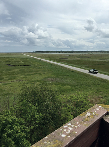
Fig. 23 Holocene plain of beach ridges at Nyord–Ulfshale. View towards east.
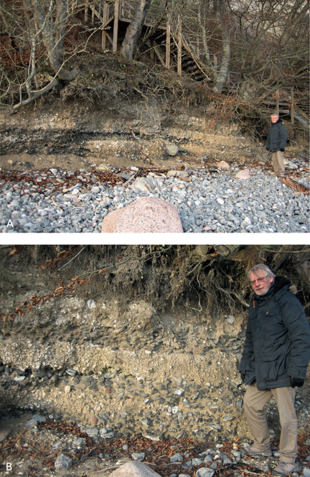
Fig. 24 Generations of Holocene beach ridges at Gråryg close to Møns Klint. A: Overview of the locality with recent beach deposits. B: Details of the oldest beach ridges.

Fig. 25 Geological profile G–H, annotated with formation names and other geological units (compare with the corresponding profiles and legend on the map sheet). This and the other profiles shown on the map sheet have been constructed and interpreted based on well data from the map sheet area. Meltwater sand and gravel (red), meltwater clay and silt (orange) and clayey tills (brown) dominate the Quaternary deposits. The profile is orientated E–W through the central part of Møn from Stege to Høje Møn.
Aeolian dune formation
Present beach ridges in the coastal areas, typically covered by aeolian dunes, can be seen on the coast at Klintholm Havn and Råbylille as well as along the north-eastern coast of Ulvshale. Aeolian deposits on freshwater sediments occur in a few places.
Holocene development
In the Preboreal, in the first part of the Holocene, the temperature was rapidly increasing. This was followed by a short cold spell before the climate again became warmer and dry, with migration of grasses and herbs. In the shallow lake at Tøvelde, algal gyttja with a high organic content was deposited first, followed by characean gyttja when the water level increased (Mikkelsen 1949; Noe-Nygaard & Heiberg 2001). During the cold spell, the gyttja was covered by washed-out clay. When the climate again became warmer, new gyttja was deposited, and birch, pine, aspen and later beech, oak, elm and hazel migrated in.
At the transition to the Holocene, a shallow lake existed in the Borre Sø depression, which was originally a U-shaped meltwater channel from the retreating Young Baltic Ice (Fig. 22). In Preboreal and Boreal time, this became a bog with tree growth.
In the Preboreal and in the early part of the Boreal, the so-called terrestrial period, a land bridge existed that connected Denmark to southern Sweden and southern England. The Baltic Ice Lake still existed at the onset of the Preboreal but was drained 10 300 BP.
The Tøvelde lakes were overgrown with plants, or tree trunks had collapsed into them during the Boreal. The lakes gradually changed into bogs, and thick layers of bog peat with numerous shells of freshwater molluscs and bivalves were formed. The Baltic region was again covered by a large lake, namely the Ancylus lake, which was reminiscent of the Baltic Ice Lake that had existed a few thousands of years before.
In the Atlantic time, large parts of Denmark were inundated by the Littorina Sea. Low-lying areas along the coasts of Møn and old fjords like Borre Sømose became part of this sea (Fig. 22; Krog 1979). Deposition of thick marine layers of Cardium gyttja continued from Atlantic into Subboreal time. An extensive flora and fauna are known from this period.
In Subatlantic time, lacustrine and marine conditions alternated in the low-lying areas and were accompanied by alternating deposition of freshwater and calcareous gyttja. The changing depositional environment was also influenced by temporary barriers in front of fjords such as Borre Sømose, which in turn reflected the varying sea level. Many lakes were formed towards the end of this period. These lakes grew, peat was formed, and eventually the lakes became bogs.
The recent marine deposits mostly consist of sand, gravel and stones, with the latter grain sizes predominating in the beach ridges. Such deposits on and below the sea floor have been explored for commercial use in Hjelm Bugt and Fakse Bugt (Fredningsstyrelsen 1977, 1986). The results were compiled by Jensen (1993). The funnel-shaped mouth of Grønsund in the strait between Falster and Møn contains a central channel bordered by flats and barriers formed by storm currents. The youngest deposits are aeolian sand dunes, which are mainly located along the coasts.
Distribution and structure of the lithological units
The position of the Cretaceous chalk, the distribution of chalk sheets overlain by Quaternary units and the distribution and structure of the Quaternary formations are documented in four cross-sections A–B, C–D, E–F and G–H through Møn, which are shown on the map sheet. Two additional profiles, namely a historic profile of Møns Klint and one of Hvideklint, are included in the present volume. The four profiles are based on data from drill holes within the mapped area extracted from GEUS’ Jupiter database (Gravesen & Fredericia 1984), information from ground water exploration (Rambøll 2006, 2007), gravel pits (Region Sjælland 2012) and the coastal profiles. In this volume, the western part of cross-section G–H is reproduced as Fig. 25 with the new formal stratigraphical units indicated. The profiles of the coastal exposures also contain structural interpretations of the sequences at depth.
The four borehole-based cross-sections represent an overview of Møn’s interior three-dimensional structure from top-chalk to surface (Fig. 26). Møns Klint is seen in Fig. 27, which is a modified version of Puggard’s (1851) classic cross-section. The cross-section along the eastern 800 m of Hvideklint to Hjelm Nakke in Fig. 28 is based on a new survey supported by that of Stockmarr (1996).
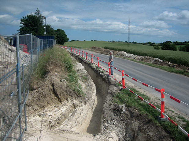
Fig. 26 Elevated chalk sheets exposed in an excavation at the transformer station in Neble.
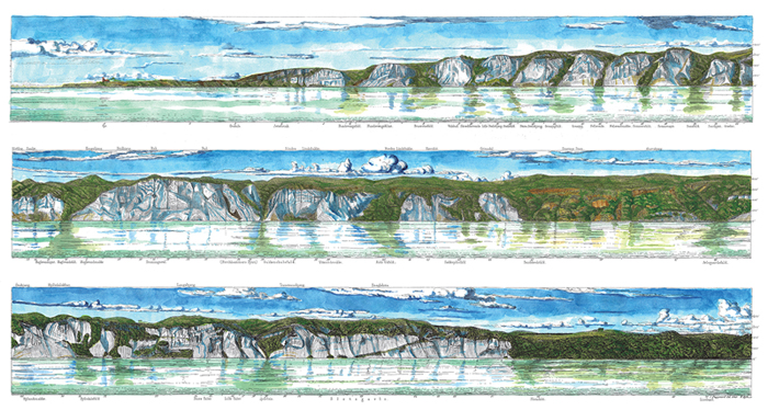
Fig. 27 The Møns Klint profile as measured by C. Puggaard at around 1850.
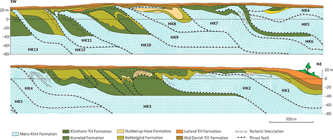
Fig. 28 The structure of Hvideklint based on new measurements supplemented by information from Stockmarr (1996). HK1 to HK12 refer to individual chalk sheets numbered from northeast to southwest. These are also used in Figs 29–39 from Hvideklint.
Geological cross-sections based on drilling
Cross-section A–B
The NW–SE-oriented cross-section A–B transects western Møn. It runs from Hvideklint in the north-west, continues through Nørre Frenderup, Kostervig, the Koster peninsula and Ulvsund, and ends at Gammel Kalve have on Sjælland.
The hummocky moraine landscape at Gammel Kalvehave and Koster Land is surrounded by a Holocene marine foreland. At Damsholte, a SW–NE-trending valley is crossed, which contains meltwater clay, sand and gravel deposited during the NE Ice Advance and is interpreted as a tunnel valley (Rasmussen 1965; Smed 2014). This valley can be followed towards north-east through Stege Nor, but as is evident from the cross-section, it has been modified by the Young Baltic Ice Advance. Stege Nor and the hills to its south-east form a composite of parallel valleys and hills formed by the advance from the south-east of the Young Baltic Ice. In the south-eastern part of the cross-section, there are redeformed thrust sheets of chalk in Hvideklint. The chalk surface is unaffected by glacial tectonics and is approximately horizontal with an elevation of 20–30 m below sea level (Fig. 2), but in cross-section A–B only at Æbelnæs south-east of Kostervig.
Cross-section C–D
The N–S-oriented cross-section C–D begins in Hjelm Bugt at Råbylille Sø, continues northwards over eastern Møn and over the high ground at Elmelunde and reaches the north coast at Nordfelt west of Borre Sømose. The hummocky moraine landscape belongs to the Lolland Till Formation from the Young Baltic Ice Advance. Meltwater sand and gravel of the Ny Borre Formation are exposed around Elmelunde, which has been uplifted by glaciotectonic sheets of chalk. The two above-mentioned formations can be followed all the way through the profile. In the south, Holocene freshwater deposits are found in the E–W-oriented lake of Råbylille Sø, which is located in a depression that may be interpreted as part of the Råbylille tunnel valley. The lake is overgrown and contains peat. Along the coast there is aeolian sand. The almost flat chalk surface is 30 –40 m below sea level throughout the profile.
Cross-section E–F
The SW–NE-oriented cross-section E–F begins at Stege and continues over Damsholte, Røddinge Sø and Store Damme to Fanefjord. The till landscape of Stege consists of smallish elongate hills oriented SW–NE, which rest on tectonic slices of chalk. The whole profile follows a valley structure, which has drained the melting NE Ice. Part of the valley is interpreted as tunnel valley with small eskers including Fanefjord Ås and hat-shaped hills (Rasmussen 1965; Smed 2014). The entire valley system including the Røddinge Sø channel subsequently served as a drainage channel for the Young Baltic Ice, and the Ny Borre Formation was deposited here. The Røddinge depression is now overgrown and contains peat. Fanefjord is surrounded by Holocene marine sand, and coarse-grained beach ridges are found along the coast of the Baltic Sea.
Sheets of chalk were exposed in the summer of 2015 when electric cables were dug in next to the transformer station outside eastern Neble (Fig. 26). These exposures suggest that the chalk sheets in the eastern third of the profile were probably underestimated when the profile was constructed ten years earlier. As seen in Fig. 26, the chalk reaches the land surface. West of Neble, the chalk surface is almost unaffected by glacial tectonics, and the pre-Quaternary surface is subhorizontal at a depth of 25 –30 m below sea level.
Cross-section G–H
The longest cross-section G–H is oriented E–W through central Møn. From Stege it continues over Råbylille, Råbymagle, Borre Sømose, Busemarke, Store Klinteskov to Møns Klint at Store Klint and Dronningestolen. Part of this profile without Høje Møn is shown in Fig. 25 with retained and new formation names indicated.
In the eastern part of the Høje Møn area, the large chalk sheets have been pushed up to 125 m a.s.l., with a thin cover of glacial, interglacial, late glacial and postglacial deposits. Adjacent to this elevated area is a marked depression with Borre Sømose, which drained the Young Baltic Ice and contains lateglacial to postglacial deposits as well as sand and gravel of the Ny Borre Formation. The area south of Elmelunde is a relatively elevated hummocky till landscape. Holocene marine sand was deposited along the margin of Stege Nor.
Part of the profile in Fig. 25 illustrates the interpreted structure of the lithostratigraphic units in the interior of Møn, which, however, cannot be directly compared with the coastal profiles because of the different nature of the underlying data. The profile shows the following formations: Ristinge Till, Kraneled, Klintholm Till, Kobbelgård, Mid Danish Till, Ny Borre and Lolland Till. West of Høje Møn the chalk surface is subhorizontal with elevations mostly between 30–40 m and locally 20 m below sea level. It is presumed that the autochthonous chalk surface east of the chalk sheets of Høje Møn is located more than 100 m below sea level. Isolated pockets of chalk of variable size occur in the Quaternary deposits (see also Houmark-Nielsen 2003).
Chalk profiles in coastal cliffs
Møns Klint
Møns Klint is an impressive coastal profile, which provides a N–S-trending erosional section through the unusually steep, hilly and elevated landscape of Høje Møn. It has been known for over 150 years that the morphology of Høje Møn is due to stacked sheets of chalk (Puggaard 1851; Schou 1949; Pedersen 2000), and the overall structure has been interpreted as a result of glacial tectonics for more than 100 years. In the last, Weichselian glacial period, an ice stream advanced from the Scandinavian ice cap through the Baltic Sea towards Kattegat, and sheets of chalk and their overlying deposits were pushed up to form glaciotectonic complexes on Møn and Rügen in Germany (Johnstrup 1874; Gripp 1948). Møns Klint constitutes an international key locality for glacial tectonics (Fig. 27; Slater 1927; Aber et al. 1989; Pedersen 2000, 2014).
Møns Klint is structurally divided into a proximal imbricated complex in its southern part, an antiform stack in its central part and shallowly dipping foreland thrusts in its distal northern part (Pedersen 2000). The northern part of Møns Klint has been especially affected by superimposed deformation. This was caused by a terminal ice advance from Skåne prior to 16 000 BP when Denmark became ice-free.
The imbricated complex in the proximal, southern part of the cliff is characterised by a few steep sheets such as Hvidskud, St. Stejlbjerg and Sommerspir. These structures are shown in the block diagram on the geological map (the drawing ’Stratigraphy and structures of Møns Klint’). Note that the elevation of the décollement surface is c. 100 m below sea level (Fig. 42; Pedersen 2000). The southernmost part of the complex is Jættebrinken, which consists of three imbricated chalk sheets that are now flat-lying (Fig. 27). Glacial sediments occur in a depression south of Jættebrinken, where the chalk surface is below sea level. A path from the lighthouse to the sea at the southern point of Møns Klint traverses the glacial deposits, which are however concealed by dense shrubbery. The southern part of Møns Klint is interpreted as the location where the advancing ice was in direct contact with the hinterland of the imbricate thrust sheets. The till deposited here is interpreted as belonging to the Lolland Till Formation. It acquired an increased thickness during prolonged deposition in the tectonic depression behind the glaciotectonic complex.
Hundefangsfaldet separates Jættebrinken from Hundefangsklinten farther north, which is the first of the steep cliffs in the proximal zone (Figs 27, 42). This zone continues to Sommerspirpynten, where the wide ‘gutter’ of Sandfaldet has acquired its name from abundant local meltwater sand. Sandfaldet is interpreted as a piggyback basin, where a river of meltwater flowed through the valley between the Sommerspir sheet and the next sheet north of Sandfaldet, while the sheets were being moved forward by the ice pressure. The sheet north of Sandfaldet extends from Græderen to Maglevandsfaldet (Fig. 27). Along its flanks, the sand overlies the lower side of the Sommerspir sheet and the upper side of the sheet at Græderen. The sand is mildly folded into a syncline as a drag structure along the imbrication thrust. These features show that the sand was deformed by contemporaneous glaciotectonic processes more or less contemporaneously with its deposition.
A detailed structural study of the area below Geo-Center Møns Klint (Pedersen 2003; Pedersen & Gravesen 2009) has shown that the structures at Dronningestolen resulted from overthrusting of several flat-lying sheets in the early phase of the deformation (Figs 27, 42). This was followed by collective transport over a more deepseated ramp, whereby the sheets were folded into a hanging-block anticlinal structure (Pedersen 2000).
The thrust sheets in the distal part of the glaciotectonic complex are moderately inclined towards the south (Fig. 27, 42). Field work by the authors has shown that they extend into the foreland, which consists of Kobbelgård Formation clay. An unusual roll-over anticline is exposed below Nonnebrinken.
Hvideklint
The more than 1 km long and about 20 m high coastal cliff of Hvideklint faces the western part of Hjelm Bugt. The profile is oriented NE–SW and provides an erosional section of the hummocky landscape of south-western Møn (Fig. 28). The cliff, which appears as a shiny white stretch from a distance, consists of more than 13 chalk sheets with intercalated glacial deposits.
The overall structure of Hvideklint and its interior architecture are controlled by three glaciodynamic factors: (1) Sheets of chalk were first pushed up from south-east towards north-west by the NE Ice Advance. (2) The thrust sheet complex was then deformed by the Young Baltic Ice Advance from south-east towards north-west. (3) The deformation of the chalk-clay association resulted in extensive brecciation and formation of mud diapirs (Aber 1979; Berthelsen 1979; Stockmarr 1996). The cross-section of the Hvideklint structures shown in Fig. 28 is based on a survey of the cliff, strike and dip measurements of depositional layers and thrust sheets, measurement and construction of fold axes and volumetric considerations (balanced cross-sections, Pedersen 2005). The structural interpretation is supported by the constructed top of chalk map of Fig. 2 and the cross-section E–F on the map sheet, both of which are based on borehole data mostly from western Møn. The cross-section also acts as a model for the hummocky landscape around Hjelm and Nørre Frenderup.
The cross-section begins at a small stream crossing the beach below Ørbæklund. The north-easternmost c. 300 m of Hvideklint (HK) are dominated by the chalk sheets HK1 and HK2. A narrow, overturned syncline on top of HK1 contains the lower units of the Kobbelgård Formation. The folding has also affected the uppermost part of the underlying chalk, which has been converted to a chalk-glacitectonite. The folded material is truncated by a thrust overlain by the Mid Danish Till Formation. The Lolland Till Formation discordantly overlies the entire coastal profile. The thrust contact itself between HK1 and HK2 is not always well exposed but can nevertheless be identified where the south-western flank of the up-thrust hanging-wall block anticline (HK1) anticline is almost perpendicular to the top of the shallowly NE-dipping layering in the upper part of HK2. Increasing glaciotectonic brecciation obscures the larger structures towards the nose of HK2, which has been pushed up along a c. 45° NE-dipping thrust, where the clay of the Kobbelgård Formation has been inverted along the south-western flank of the anticline.
A 120 m stretch of slumped and overgrown glacial deposits separates the chalk exposure at the nose of HK2 and another exposure showing the top of HK3. An overturned syncline in the north-eastern part of this stretch has an E–W-oriented fold axis, which indicates thrusting from the south (Fig. 29). The syncline and the accompanying thrust dip steeply to the south. Accordingly, the fold structures related to the NE-directed thrusting from north-east have been succeeded and redeformed by N-directed thrusting from the advancing Young Baltic Ice. The syncline overturned towards the north is clearly visible in the laminated and thinly bedded meltwater sediments of the Kobbelgård Formation (Fig. 29).
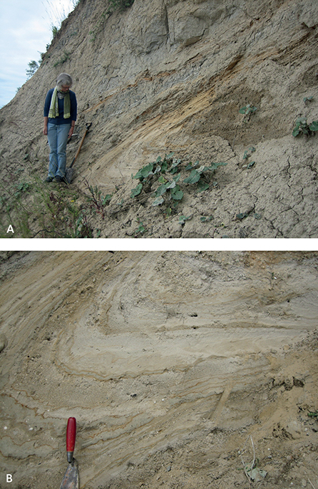
Fig. 29 Folds at Hvideklint. A: Overturned syncline in sheet HK3 with an E–W-oriented fold axis. The light glaciofluvial sand of the Stubberup Have Formation is folded into the darker clay of the Kobbelgård Formation. B: The nose of the overturned syncline includes alternating layers of clay, silt and sand.
In the same stretch towards the top of HK3, there are three to four imbricated thrust sheets dominated by the clay of the Kraneled, Klintholm Till and Kobbelgård Formations. Since there are no exposures of chalk between these sheets, they are interpreted as having been carried tectonically piggy-back on HK3. It is estimated from the interpreted profile that these sheets are rooted in the top of chalk unconformity, 35 m below sea level. Considering that the maximal thickness of the exposed sheets is about 15 m, it is expected that the detachment zone of the chalk slices themselves is at least 15 m deeper. It is indicated in the profile that the detachment zone is located 80 m below sea level, but at this depth only chalk would be thrust over in situ chalk.
The chalk slices HK3, HK4 and HK5 form a contiguous complex, which may be interpreted as an antiformal stack. That is to say, the slices were first pushed laterally on top of each other and then thrust over an underlying ramp below HK5. A small separate chalk wedge transects the nose of HK4 and is interpreted as having been pushed up from the south.
HK6 is a thin slice of chalk, which has been thrust over the relatively thick chalk sheet HK7. The separating thrust is associated with an isoclinally folded syncline of dark clay, which presumably belongs to the Kraneled Formation (Fig. 30). The chalk of HK6 and the upper part of HK7 is broken up and brecciated and is best described as a chalk glacitectonite. The nose of HK7 has been thrust over the top of HK8, where several Quaternary layers have been folded into an overturned syncline under the base of HK7. HK8 is a relatively short sheet, carried on the back of chalk sheet HK9. A still smaller and thinner sheet of chalk glacitectonite has been dragged discordantly across the noses of HK8 and HK9 at the base of the Mid Danish Till Formation. The tip of HK9 is so intensely affected by shear deformation that is intermediate between a chalk glacitectonite and a brecciated chalk till (Figs 31, 32).
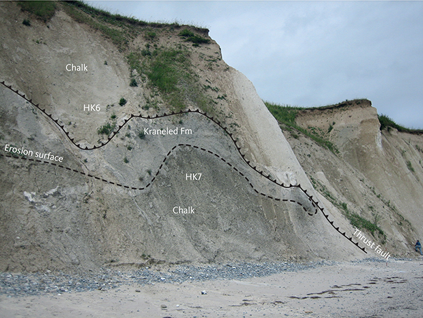
Fig. 30 Thrust fault at Hvideklint separating sheets HK6 and HK7 with an isoclinally folded syncline consisting of Kraneled Formation clay. The thrust fault can be traced throughout the photo.
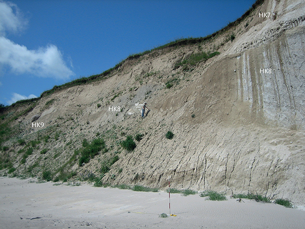
Fig. 31 Thrust faults between sheets HK7, HK8 and HK9 at Hvideklint together with the front of sheet HK9.
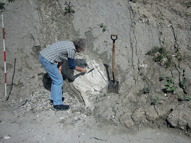
Fig. 32 Intensely deformed chalk in thrust sheet HK8 at Hvideklint, grading from chalk-glacitectonite to brecciated chalk-till deposits.
Between the chalk sheets HK9 and HK10, there are two sheets of disrupted and folded units from the Kraneled, Klintholm Till and Kobbelgård Formations. The upper of these sheets has been folded into an overturned anticline, and the layers along their mutual thrust contact have been intensely deformed by reverse faulting (Fig. 33). Dark clay occurs on the top of HK10, which can be assigned to the Kraneled and Klintholm Till Formations. Strongly reversely displaced, sandy layers belong to the Kobbelgård Formation. Three different lodgement tills occur at the frontal part of HK10; sandy and clayey sediments of the Kobbelgård Formation separate the tills of the Klintholm Till Formation from those of the Mid Danish Till and Lolland Till Formations (Fig. 34).
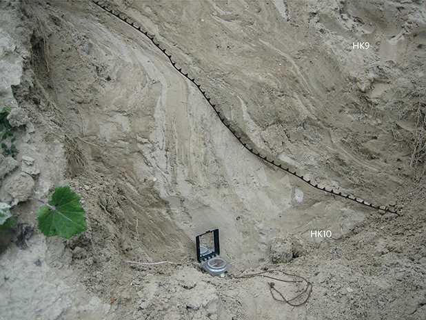
Fig. 33 Folded and thrust-displaced layers at Hvideklint, representing parts of the Kraneled, Klintholm Till and Kobbelgård Formations between the sheets HK9 and HK10.
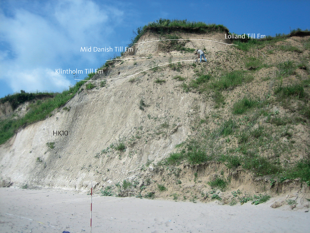
Fig. 34 Cretaceous chalk at the front of sheet HK10 at Hvideklint, overlain by a succession of Quaternary deposits including the Kraneled, Klintholm Till, Kobbelgård, Mid Danish Till and Lolland Till Formations.
The chalk sheets HK11 and HK12 are relatively thin and have steep orientations (Fig. 35). Because of shear deformation there are both layers and lenses of black clay in chalk and layers and lenses of chalk in dark clay (Figs 36, 37). Towards south-west from HK11, there are increasing occurrences of clay, mainly of the Kraneled and Kobbelgård Formations, which have caused increased sliding and blurring of the coast profile (Fig. 38). An additional chalk slice, HK13, has been identified farther south-west towards Hjelm Nakke. However, the tectonic structures are so complex that is meaningless to construct a profile. An example of the complex defor mation patterns can be observed in mud diapirs, which occur where water-saturated clay deposits have been subject to glaciotectonic deformation (Fig. 39). defor mation patterns can be observed in mud diapirs, which occur where water-saturated clay deposits have been subject to glaciotectonic deformation (Fig. 39).
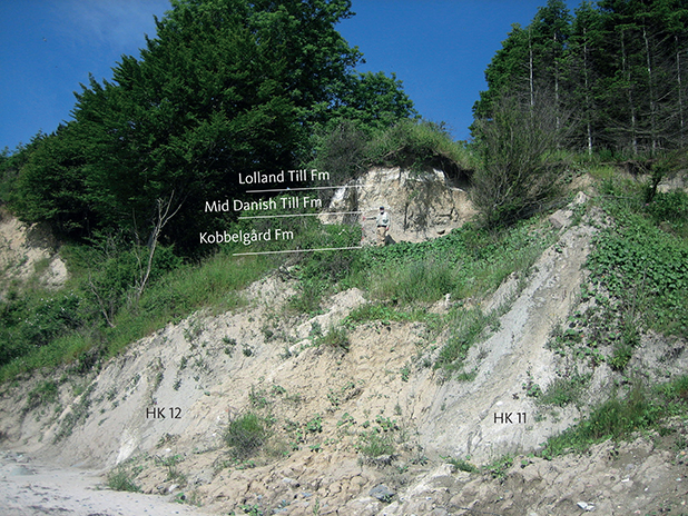
Fig. 35 The steeply dipping chalk sheets HK11 and HK12 at Hvideklint, truncated by the almost horizontally deposited Lolland Till Formation including a lens of chalk-glacitectonite. Person for scale in centre of photo.
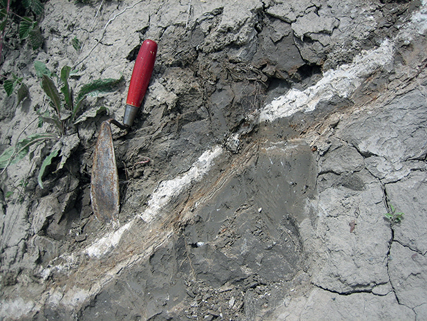
Fig. 36 Thin layers of chalk-glacitectonite at Hvideklint, which were squeezed up above the existing pile of chalk sheets HK1–HK12. The thin chalk layers and lenses have been sheared into the dark clay of the Kobbelgård Formation.
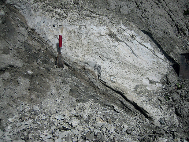
Fig. 37 Lenses and thin layers of clay in the chalk of sheet HK8 at Hvideklint, deformed by thrust faulting. The chalk has completely lost its primary sedimentary layering and has been transformed into a glacitectonite.
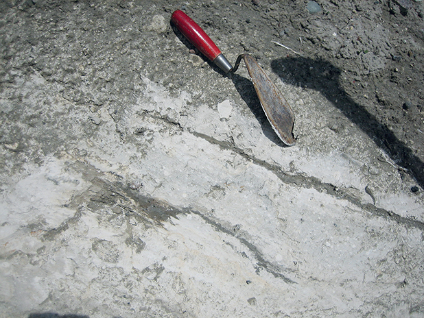
Fig. 38 Brecciated clasts of chalk in mud along the sole of the thrust faults at Hvideklint. The large mud content in the Kraneled and Kobbelgård Formations commonly blurs exposures of the south-western part of the cliff.
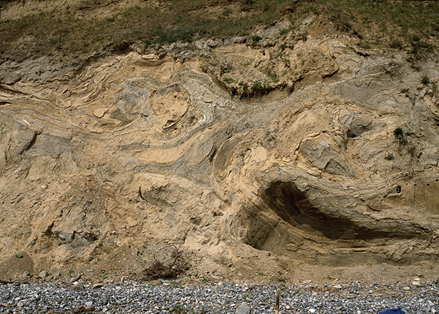
Fig. 39 Mud diapirism at Hvideklint formed during glacial tectonic deformation of water-saturated clay deposits. The exposure is almost 2 m high. Photo: Tove Stockmarr (1996).
Glaciodynamic sequence stratigraphy
Pedersen (2012a) proposed a glaciodynamic sequence stratigraphy for terrestrial glacial deposits, which both includes the formation of glaciotectonic complexes and the deformed lithologies themselves (the so-called glacitectonites, Pedersen 1988, 2014; Pedersen et al. 2018).
A glaciodynamic sequence corresponds to a glaciodynamic event. The base of a glaciodynamic sequence is the deepest level affected by the corresponding event. In a complete glaciodynamic sequence, this is the basal detachment level of the glaciotectonic deformation, i.e. the most deep-seated level where glaciotectonic offset occurs. The individual units within the complex are found above this level. They may consist of pre-Quaternary units such as glacially deformed chalk, as well as pre- and proglacial formations such as meltwater deposits. The base of such a complex is an angular discordance, above which a glacitectonite is formed at the base of a lodgement till. The top of the glaciodynamic sequence is the top of the lodgement till that was deposited during the ice advance that caused the glaciodynamic event (Fig. 40). Four different glaciodynamic sequences can be differentiated on Møn, namely Klintholm, Hvideklint, Møns Klint and Aborrebjerg.
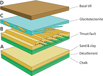
Fig. 40 The concept of glaciodynamic sequence stratigraphy (after Pedersen 2012a). A: Location of the basal décollement zone in the upper part of the chalk. B: Formation of thrust fault imbricates consisting of chalk and glacial deposits. C: Truncation of the glacier sole during formation of glacitectonite. D: Final deposition of lodgement till above the glacitectonite.
Klintholm Glaciodynamic Sequence
The coast profiles east and west of Klintholm contain dislocated units of meltwater clay and sand as well as diamict deposits, which may either be lodgement tills or dropstone tills (see discussion on the formation of diamict deposits in Houmark-Nielsen 1994). Variable amounts of chalk and chalk sheets have been worked into the basal parts of the glacial deposits. The chalk sheets have been pushed up from east to west and are discordantly overlain by dark grey clayey till. This sequence is named the Klintholm Glaciodynamic Sequence. The corresponding glaciodynamic event took place during the earliest (Ristinge) ice advance in the early to middle Weichselian c. 55 000–50 000 BP. In terms of climate, the event was followed by the Sandnæs mild period.
Hvideklint Glaciodynamic Sequence
The glaciotectonic complex of Hvideklint consists of about 15 sheets of chalk above the top of chalk unconformity and includes variable amounts of glacial material attached to the upper surfaces of the sheets. All the sheets are truncated by the overlying Mid Danish Till Formation, commonly with a smeared-out unit of chalk glacitectonite 0.5–1 m thick at its base. This sequence is named the Hvideklint Glaciodynamic Sequence. It was formed by the predominant NE Ice Advance, which spread out from a source area in central Sweden to the main stationary line in Denmark, northern Germany and Poland. On Møn, the ice advance was directed from north-east to south-west. Also, the second phase of the Præstebjerg hill complex is included into this glaciodynamic sequence. The glaciodynamic event took place in the latter part of the Weichselian glaciation during the LGM.
Møns Klint Glaciodynamic Sequence
The glaciotectonic complex of Høje Møn is a contiguous glaciotectonic unit that was pushed up from south towards north. Its base is a detachment surface c. 100 m below sea level (Pedersen 2000, 2003; Pedersen & Gravesen 2009); its depth was estimated using the principles of balanced glaciotectonic cross-sections described by Pedersen (2005, 2006). Above this surface, the chalk is no longer in situ. The glaciotectonic complex has a classic internal structure comprising, from south to north, a proximal, a central and a distal part. The tops of the chalk slices and their intercalated glacial deposits are truncated by the lodgement till of the Lolland Till Formation, commonly including a dragged base of chalk glacitectonite. This sequence is here named the Møns Klint Glaciodynamic Sequence. The associated event is ascribed to the rapidly advancing Young Baltic Ice at about 18 000 BP, which was also responsible for phase 3 and possibly 4 of the Præstebjerg hill complex (see the chapter on landscape formation). The glaciodynamic formation of Møns Klint has controlled the overall structure of the entire island of Møn and particularly the coastal area facing Hjelm Bugt (Fig. 41) and the superimposed deformation of Hvideklint.
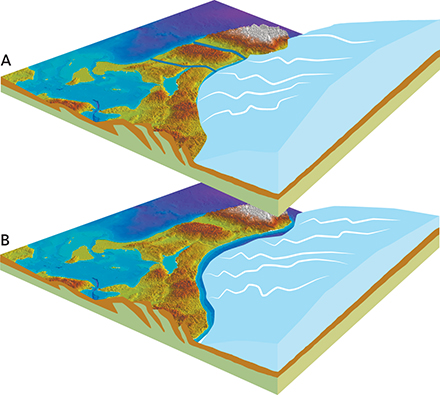
Fig. 41 Block diagrams showing the formation of Møn’s hilly landscape in front of the Young Baltic Ice. A: The Young Baltic Ice occupying the depression in Hjelm Bugt. B: Exposure of an arcuate, hilly landscape during meltback of the ice. Note that the hills are cut by valleys formed by meltwater spillways from the adjacent ice margin along the south coast of Møn.
Aborrebjerg Glaciodynamic Sequence
The northern half of the glaciotectonic complex of Møns Klint has been superimposed by glaciotectonic thrusting from north-east (Fig. 42; Pedersen 2000). The best example of this is the chalk sheet at Vitmunds Nakke, which has clearly been pushed up from north-east towards south-west and which also displaces the Lolland Till and Mid Danish Till Formations and older glacial units. An analysis of the superimposed folds shows that Aborrebjerg itself constitutes the culmination of a fold of a fold (Fig. 43). The sequence is therefore named the Aborrebjerg Glaciodynamic Sequence.
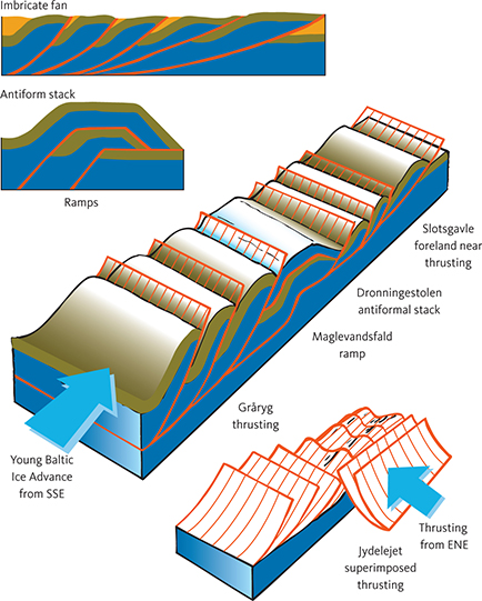
Fig. 42 The structural evolution of Møns Klint (after Pedersen 2000). Blue: chalk. Brown and orange: glacial deposits. Red: thrust faults. Blue arrows show the directions of ice push from the SSE and ENE, respectively.
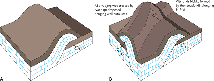
Fig. 43 Formation of Aborrebjerg and Vitmunds Nakke. Aborrebjerg is the highest point of Møn and was formed during two separate events: A: Superimposed thrust fault deformation by the Young Baltic Ice Advance from the south (F1). B: Superimposed faulting by the latest ice advance from southern Sweden (F2).
The thrusting corresponds to an ice advance from the area north-east of Møn, where the receding Young Baltic Ice must have extended a ‘piedmont’-shaped ice tongue during its general meltback. A SW-facing ice front displaced the already previously displaced chalk sheets. According to the established models for the meltback of the Young Baltic Ice, this re-advance must have taken place 16 000 BP (Houmark-Nielsen 2010, Houmark-Nielsen et al. 2017).
Landscape features and their formation
Geomorphological description
The following geomorphological description is based on the geological map and a terrain model of Møn (Fig. 44).
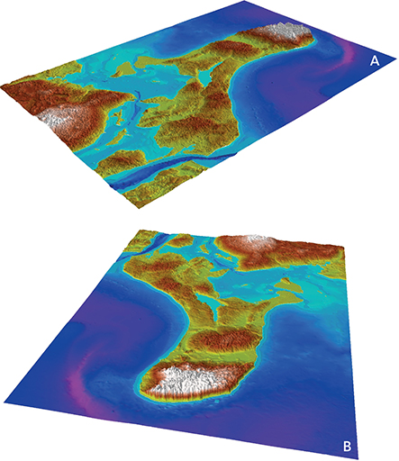
Fig. 44 Geomorphological elevation model of Møn. A: Viewed towards north. B: Viewed towards west. Yellow-green: 0–25 m a.s.l. Brown: 25–50 m a.s.l. White: above 50 m a.s.l.
Glaciotectonic landscape with composite ridges
The most characteristic morphological feature of Høje Møn is the elongate, parallel ridges separated by long and narrow valleys. The ridges consist of glaciotectonic thrust sheets of chalk. The chalk is commonly present at the surface in Store Klinteskov and best observed after major storms, when the chalk becomes exposed around the roots of fallen trees. In the southern part of Klinteskoven the ridge orientation is E–W. Characteristic examples are Gråryg with the adjacent elongate valley of Nælderende on its northern flank. Farther south, the ridge orientation turns towards ESE–WNW, as in the valley of the Siesøerne lakes and the adjacent Siesø Bjerg to the north. The ridge that extends into the wood from Dronningestolen may also be considered part of the E–W-oriented hill system. Farther north, there is a marked change in the ridge orientation to SE–NW. A few of the ridges close to the cliff reach a SSE–NNW orientation, which can also be observed in the lake depressions from Hunesø to Liselund.
Based on the glaciodynamic interpretation of the Møns Klint complex, the hills can be classified as composite ridges. Their changing directions are interpreted as resulting from an initial pressure from the south-east by the Young Baltic Ice, which created the ridges, followed by an ice advance from Skåne in the north-east towards the end of the Weichselian, which redeformed and to some degree also re-oriented the ridges (Pedersen 2000). An E–W ridge orientation is also observed in the glacial morphological landscape around Stege Nor, which can itself be considered a morphological element that follows the orientation of the ridges. The highest points in the landscape are interpreted as corresponding to places where the underlying chalk was already pushed up from north-east.
Moraine plateaus
About 70% of the surficial material on Møn consists of clayey till, which almost entirely belongs to the Lolland Till Formation. Apart from Store Klinteskov and a few other elevated hill areas this landscape can be characterised as a lodgement till landscape forming a flat, levelled terrain with scattered lows without outlets. The lows are depressions left by former lumps and sheets of ice buried in the clayey till during the Young Baltic or earlier ice advances (Fig. 45).
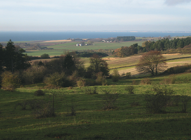
Fig. 45 The boundary between the elevated landscape of Høje Møn and the landscape towards the west of the lower, undulating till plain. The white cliffs of Hvideklint can just be seen in the horizon on the far side of Hjelm Bugt.
The till is underlain by meltwater sand of the Ny Borre Formation. The sand appears in the valleys, as easily observed east and west of Stege Nor. Towards the south-west from Stege Nor, the sand is widespread in the depression around Damsholte and Røddinge Sø and in the valley extending towards Fanefjord.
Hat-shaped hills and superimposed eskers
On western Møn, several hills may be interpreted as hatshaped hills or eskers, which have been affected by later ice advances than those responsible for their original pro- and intraglacial deposition. The next sections describe the processes that formed the proglacial deposits and their subsequent deformation along the ice margin. The intraglacial deposits were formed in tunnel valleys under the ice or in large ice-dammed lakes with margins and bases associated with fracture zones in the ice. After the meltback, such deposits stand out in the landscape as hills of sand and gravel, which are described in the older literature as hat-shaped hills (Berthelsen 1980). It remains uncertain how many of the hills in western Møn can be considered hat-shaped hills, but one of them, Præstebjerg, has been exploited as a gravel pit, which allowed a study of its interior structure during its excavation (Fig. 46; Berthelsen 1980).
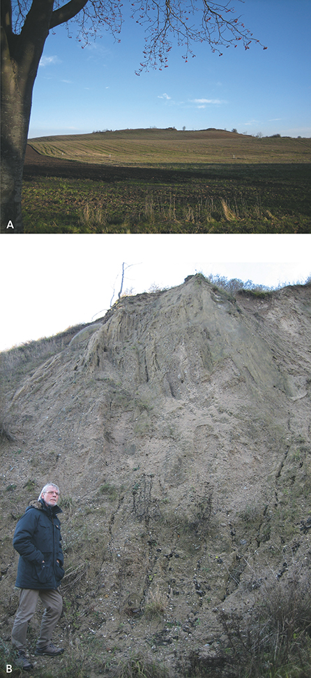
Fig. 46 The hat-formed hill of Præstebjerg on western Møn. A: The hill viewed from the south, with excavated material at its top. B: Vertical layers of meltwater sand and gravel inside the hill, cut and overlain by clayey till of the Lolland Till Formation.
The main criterion that defines a hat-shaped hill is that it stands out as an isolated hat in the landscape. It is also required that the internal layering is deformed, oblique and steeply dipping. This criterion is ascribed to Berthelsen (1980), who excluded a large number of hills with this exterior shape but without dislocations, for example on Langeland. An investigation of Præstebjerg by Berthelsen (1980) demonstrates that the depositional and deformational processes in hat-shaped hills may be very complicated. In the first phase of his interpretation, the material in the Præstebjerg hill was deposited as a proglacial meltwater plain, which was then folded by an ice advance from south-east, probably the Klintholm Ice Advance (Fig. 47); without a detailed OSL or infrared stimulated (IRSL) age determination it is impossible to establish if the ice advance represented the ice of the Ristinge Klint Till Formation or that of the Klintholm Till Formation, although the layers have clearly been deformed towards north-west by a Baltic ice. The second phase (phase 2 in Fig. 47) is that of the overriding NE Ice. Just before the lodgement till of the Mid Danish Till Formation was deposited, the sandy hill was deformed by a SW-directed ice pressure. The third phase began with strong erosion of the northern hill flank by a meltwater stream, which subsequently deposited a thick package of meltwater sand and gravel. The deposition took place in front of an ice advance from the south-east, which then covered the hill and deposited a thin layer of lodgement till. In the fourth and final phase, the hill was covered by a second ice advance from south-east, which folded the layers inside the hill on a NE–SW-trending fold axis and overturned the folds towards NW (Fig. 47). It is suggested in this interpretation that the two latest ice advances were oscillating and related to the ice stream that deposited the Lolland Till Formation.
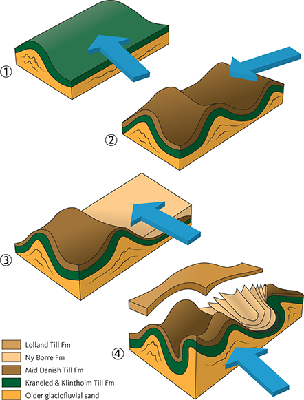
Fig. 47 Model for the formation of Præstebjerg. 1: Folding of the Kraneled and Klintholm Till Formations during the Klintholm Ice advance from east-south-east. 2: Superimposed folding and deposition of the Mid Danish Till Formation by the NE Ice advance from northeast. 3: Glaciofluvial erosion by meltwater streams moving from east to west and deposition of the Ny Borre Formation. 4: Superimposed deformation due to the Young Baltic Ice advance from south-east and deposition of the Lolland Till Formation. Partly from Berthelsen (1979).
Marginal moraine landscape and meltwater plains
A large accumulation of meltwater sand and gravel occurs from Ny Borre southward to Busemarke. Two of Møn’s largest gravel pits were also found in this area at Ny Borre and in the western outskirts of Busemarke. Towards the south, the area is bounded by the marginal moraine hills north and south of Råby Sø and Busemarke Mose, with the most prominent hilltop located at Kobbelgård. Together with other hill stretches parallel to the coast of Hjelm Bugt, these hills form a terminal moraine landscape. In front of the hills, a meltwater plain stretched from Busemarke to Ny Borre. Farther north, erosion by the same meltwater created the broad depression of Borre Sømose. The American ex pression for a landscape formed by melt water is ‘spillway’, which may be applied to the valley towards Maglemose. The depression stretching from the north coast to Borre Sømose as well as the Maglemose depression were also spillways for the meltwater when the retreating ice margin experienced a short-lived standstill at the coast of Hjelm Bugt. At this time, the meltwater mainly flowed through the valley towards Maglemose, where sand and gravel were redeposited during the Late Glacial meltback. Similar processes also controlled the areas where Stege Nor enters Stege Bugt as well as at Klostervig, Røddinge Sø and Fanefjord. In total, meltwater sand accounts for nearly 10% of Møn’s surficial deposits.
When the Young Baltic Ice finally melted away from Møn, the island was a terminal moraine landscape. Hjelm Bugt forms a lobe-shaped basin, which may be considered the source area for Møn’s Quaternary deposits.
Marine foreland with beach ridges and spits
Around 8000 BP, the inner Danish waters were inundated by the Atlantic Transgression, and sea level increased by more than 20 m. The transgressive marine deposits are located in low-lying coastal areas and form c. 10% of the deposits on Møn. It was at this time that the bogs of Borre Sømose and Maglemose were transformed into fjords, and Klostervig was a narrow strait between small islands and islets. These fjords and straits were gradually sealed off by beach ridges fed by sediment transport along the coast. The lagoons behind the ridges were overgrown and changed into bogs with thick layers of peat.
The development of the marine foreland became most prominent where it was built out by sediments transported by marine currents. Ulvshale was created in this way. Mapping of beach ridges developed into crescentic bars clearly indicate a westward transport direction along the north coast of Møn. At the northern point of the island, the marine foreland was built out towards north-west, where the beach ridges are prominent and commonly superimposed by smaller dunes. A smaller area at Hårbølle Havn is also a new marine foreland. The patterns of the beach ridges show that an angular foreland was formed by sediment transport in two opposite directions, namely southward through Grøn sund and north-westward from Hjelm Bugt through Grønsund. The transport of material to the north-western and south-western corners of Møn indicates a source area located on the eastern side of the island. It is naturally the steep cliffs of Møns Klint that have supplied erosional material, not least from the many rockfalls and landslides described next.
Rockfalls and landslides
Rockfalls only occur in a few places in Denmark, and Møns Klint is the most prominent area because of its high and steep chalk cliffs (Pedersen et al. 1989; Nadim et al. 2008; Pedersen & Gravesen 2009; Pedersen 2012b). Landslides, which occur in many parts of Denmark, are also common at Møns Klint (Nadim et al. 2008). The difference between rockfalls and landslides is lithology and topography. Rockfalls occur where a more or less consolidated lithology slides or falls from a steep or nearly vertical cliffside. Landslides occur where the lithology is water-saturated clay, and a terrain gradient of just a few degrees is sufficient. The sliding body moves slowly or moderately quickly forward on a thin film of mud at high pore-water pressure. Landslides range from mud streams to terrace-shaped block displacements.
Rockfalls
In the last 100 years, only one Danish rockfall has been reported to have caused a death. This occurred on 29th July 1994 from Maglevandsnakke just south of Dronningestolen (Pedersen 1994), and surprisingly this rockfall took place on a dry summer day. The size of the fallen block was only a few thousand cubic metres (2500–3000 m3, Pedersen 1994), but the risk of a fatal accident was high inasmuch as the rockfall occurred at a time when many tourists were on the beach. One person was killed, and since then this part of the cliff has been carefully monitored. However, it is difficult to predict where another rockfall might take place. A survey of rockfalls in the last 50 years suggests that a large rockfall occurs about every 5 years (Table 1). The latest took place in January 2007 at Taleren cliff, where 100 000 m3 of material was spread out 300 m into the sea, (Fig. 48; Pedersen 2007). That year, there were also several other rockfalls at Møns Klint and at other Danish localities. The reason for this was an unusually wet autumn, where the average groundwater table was about 1 m higher than normal. Accordingly, the pore-water pressure near the surface was very high, which reduced the rock strength and in turn facilitated jointing. Once joints have formed, the conditions for a rockfall have been created.
| Year | Date | Locality | Size | Class† |
| 1801 | Taleren | |||
| 1868 | 24/12 | Part of Dronningestolen | 3 000 000 m3 | 3 |
| 1899 | Sækkepibe Fald | 100 000 m3 | 3 | |
| 1904 | 31/12 | North of Sommerspiret and Gukkende Hule | ||
| 1905 | 05/11 | Liselund muddy landslide | 4 ha | 3 |
| 1910 | 13/03 | Hundefangsklinten | ||
| 1914 | 01/01 | Dronningestolen and Forchhammers Pynt | ||
| 1920 | 14/09 | Liselund muddy landslide | 2 ha | 3 |
| 1927 | 05/11 | Large fall at Liselund | ||
| 1927 | 22/11 | Slotsgavlene, Pomlerende, Nonnebænken, Stubberup Have | ||
| 1928 | 11/05 | Hundefangsfaldet | 10-15 ha | 3 |
| 1929 | Southern part of Dronningestolen | |||
| 1939 | 25/01 | Puggaards Pynt | Temporary peninsula 2 –300 m across | 3 |
| 1940–46 | Gukkende Hule, part of Vidmunds Nakke, Forchhammers Pynt | |||
| 1948 | 15/01 | Dronningestolen | ||
| 1952 | 24/01 | Røde Udfald and parts of Vitmunds Nakke to Puggaards Klint collapsed | Temporary peninsula 500 m across | 3 |
| 1958 | Vitmunds Nakke | |||
| 1963 | Maglevandsfaldet | |||
| 1970 | Store Stejlebjerg | 2 | ||
| 1979 | Cliff face of Sommerspiret collapsed | 2 | ||
| 1980 | Hylledalsfald | 1 | ||
| 1988 | 13/01 | Sommerspiret | 1 | |
| 1994 | 29/07 | Southern part of Dronningestolen. French tourist killed at 12:30 | 3000 m3 | 1 |
| 1998 | 04/03 | Freuchens Pynt, 100 m from the coast | 3 | |
| 2003 | 05/07 | Store Stejlbjerg, at 8:50 | 12 000 m3 | 2 |
| 2004 | 16/01 | Northern part of Jættebrinken, at 16:00 | 4000 m3 | 2 |
| 2004 | 17/03 | Sommerspirpynt | 2000 m3 | 2 |
| 2007 | 27/01 | Store Taler collapsed in the evening | 100 250 m3, peninsula 300 m across | 3 |
| 2007 | 02/03 | Freuchens Pynt, afternoon | 25 000 m3, peninsula 150 m across | 3 |
| 2007 | 30/09 | Abildgårds Fald, evening, muddy landslide, toe of slide and beach plane elevated 6 m | 2 | |
| 2009 | 15/10 | Nylands Nakke, evening. Clear sky during Autumn high pressure gave way to night frost conditions. Rockfall of existing overhang | 5000 m3 | 1 |
| 2015 | 05/12 | The cliff peak, Græderen, collapsed under storm Bodil | 1 | |
| §The table includes rockfalls of Cretaceous chalk as well as landslides of Quaternary deposits. 1: Small. 2: Medium. 3: Large. |
||||
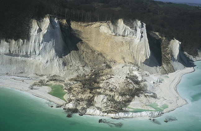
Fig. 48 Landslide at Store Taler in January 2007. Aerial photograph.
Every time a large rockfall at Møns Klint has taken place, it has resulted in a peninsula of chalk, and the fresh lumps of chalk are favoured targets for fossil hunters (Fig. 49). The area immediately below the broken cliff is usually sealed off, because smaller blocks with sizes of a couple of cubic metres are commonly released up to two days after the initial rockfall.
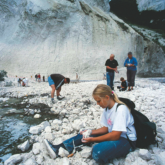
Fig. 49 After rockfalls from the cliffs, fossil hunting in the displaced chalk material is very popular. Photo: Peter Moors.
A survey of the erosion rate along Møns Klint provides an overview of rockfall conditions. A comparison of the position of the coastline in 1899 and 100 years later (Fig. 50) provides a good overview. The average annual erosion is 30 cm, which is about twice as much as other Danish coastal cliffs. However, the localities with the highest erosion, 44–49 cm/year, is not below the highest chalk cliffs but at the falls between them. For example, there is a continuous tendency for sliding at Sandfaldet between the Sommerspir cliff and Græderen south of Dronningestolen, where a spring emerges, and the sand is relatively poorly compacted.
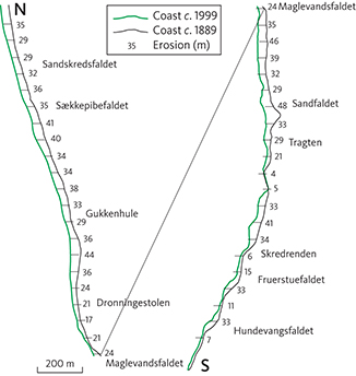
Fig. 50 Erosion and retreat of Møns Klint over time by landslides and erosion, shown as the calculated difference between the coastlines in 1899 and c. 1999.
Landslides
Landslides of cliffs containing layers of clay are common along most Danish coastal cliffs. On Møn, they are most common in the northern part of Møns Klint. The largest known single event took place in 1905, where 4 ha of Liselund Park slid into the sea after a major storm. Fifteen years later, the activity at Liselund was re-activated with a landslide of half the previous size and was resumed again in 1927. A terrace morphology and gullies from the previous landslides (Hintze 1904, 1920) are still visible today. The underlying reason for all these landslides can be observed on the beach at Liselund, where bluish grey ice-lake clay of the Kobbelgård Formation is exposed at the foot of the cliff. The landslides take place on top of this clay. Fallen trees on the beach, which consists of flint-rich gravel and stones, show that landslides are still active (Fig. 51). The clay of the Kobbelgård Formation has also caused landslides in adjacent coastal cliffs. In the autumn of 2007, a cylindric landslide took place at Abildgaards Fald, whereby the beach level at the foot of the slide was increased by 6 m (Fig. 52). The entire coastal cliff northwards from Liselund via Hellehavn Nakke to Pomlerende is dominated by landslides, which displace the Quaternary deposits that characterise the northern part of Møns Klint.
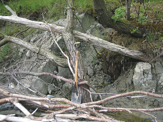
Fig. 51 Landslide on the beach below Liselund Castle with clay from the Kobbelgård Formation and fallen trees.
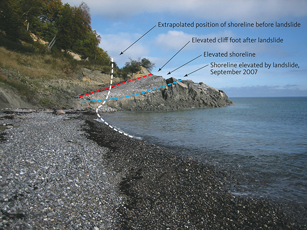
Fig. 52 Landslide at Abildgaards Fald in northern part of Møns Klint in September 2007. The toe of the slide displaced the beach plane. The three lines mark the elevated cliff foot, the elevated former shoreline and its recent position with an extrapolation.
Acknowledgements
We are very grateful to Tove Stockmarr and Gerald Hyde for permission to use their cand. scient. (M.Sc.) theses including figures and photographs. We thank Gunver Krarup Pedersen for many constructive scientific com ments to an earlier version of the text, and the two external reviewers, Helena Alexanderson and Nikolaj Krogh Larsen, are thanked for their comprehensive reading and suggestions of improvements. The authors remain responsible for the geological map sheet and the final text.
Additional information
Additional files
The Møn geological map sheet is supplied as an additional file at https://doi.org/10.22008/FK2/TMFH5W
References
Aaris-Sørensen, K., Petersen, K.S. & Tauber, H. 1990: Danish finds of mammoth (Mammuthus primigenius (Blumenbach)): Stratigraphical position, dating and evidence of Late Pleistocene environment. Danmarks Geologiske Undersøgelse Serie B 14, 44 pp. https://doi.org/10.34194/serieb.v14.7081
Aber, J. 1979: Kineto-stratigraphy at Hvideklint, Møn, Denmark and its regional significance. Bulletin of the Geological Society of Denmark 28, 81–93.
Aber, J.S., Croot, D. & Fenton, M.M. (ed.) 1989: Glaciotectonic Landforms and Structures. Glaciology and Quaternary Geology Series 5. Amsterdam: Kluwer Academic Publishers, 201 pp.
Andersen, S.A. 1936: Submarine Strandvolde i Faxe Bugt. Meddelelser fra Dansk Geologisk Forening 9, 85–88.
Andersen S.A. 1945: Isstrømmenes retning over Danmark i den sidste Istid, belyst ved ledeblokundersøgelser. Meddelelser fra Dansk Geologisk Forening 10, 594–615.
Anjar, J., Larsen, N.K., Björck, S., Adrielsson, L. & Filipsson, H. 2010: MIS 3 marine and lacustrine sediments at Kriegers Flak, south western Baltic Sea. Boreas 39, 360–366. https://doi.org/10.1111/j.1502-3885.2010.00139.x
Anjar, J., Adrielsson, L., Bennike, O., Björck, S., Filipsson, H.L., Groeneveld, J., Knudsen, K.L., Larsen, N.K. & Möller, P. 2012: Palaeoenvironments in the southern Baltic Sea Basin during Marine Isotope Stage 3: a multi-proxy reconstruction. Quaternary Science Reviews 34, 81–92. https://doi.org/10.1016/j.quascirev.2011.12.009
Banham, P. 1977: Glacitectonites in till stratigraphy. Boreas 6, 101–105. https://doi.org/10.1111/j.1502-3885.1977.tb00339.x
Bennike, O. & Jensen, J.B. 1995: Near-shore Baltic Ice Lake deposits in Fakse Bugt, southeast Denmark. Boreas 24, 185–195. https://doi.org/10.1111/j.1502-3885.1995.tb00772.x
Bennike, O., Houmark-Nielsen, M., Böcker, J. & Heiberg, E.O. 1994: A multi-disciplinary macrofossil study of Middle Weichselian sediments at Kobbelgård, Møn, Denmark. Palaeogeography, Palaeoclimatology, Palaeoecology 111, 1–15. https://doi.org/10.1016/0031-0182(94)90344-1
Bennike, O., Houmark-Nielsen, M. & Wiberg-Larsen, P. 2007: A Middle Weichselian interstadial lake deposits on Sejerø, Denmark: macrofossil studies and dating. Journal of Quaternary Science 22, 647–651. https://doi.org/10.1002/jqs.1084
Berglund, B.E., Håkansson, S. & Lagerlund, E. 1976: Radiocarbon-dated mammoth (Mammuthus primigenius Blumenbach) finds in South Sweden. Boreas 5, 177–191. https://doi.org/10.1111/j.1502-3885.1976.tb00261.x
Berthelsen, A. 1973: Weichselian ice advances and drift successions in Denmark. Bulletin of the Geological Institutes of the University of Uppsala 5, 21–29.
Berthelsen, A. 1979: Recumbent folds and boudinage structures formed by subglacial shear: an example of gravity tectonics. Geologie en Mijnbouw 58, 253–260.
Berthelsen, A. 1980: En Hatformet Bakke. Varv 3, 82–88.
Berthelsen, A., Konradi, P. & Petersen, K.S. 1977: Kvartære lagfølger og strukturer i Vestmøns klinter. Dansk Geologisk Forenings Årsskrift for 1976 , 93–99.
Cohen, K.M. & Gibbard, P.L. 2012: Regional chronostratigraphical correlation table for the last 270,000 years: North Atlantic - Greenland – West, North, East, Central Europe – Russia. Abstract INTIMATE Workshop Utrecht, Netherlands, March 2012.
Damholt, T. & Surlyk, F. 2012: Nomination of Stevns Klint for inclusion in the World Heritage List, 160 pp. Kulturarvsstyrelsen, Stevns Kommune and Østsjællands Kommune.
Ehlers, J., Eissmann, L., Lippstreu, L., Stephan, H.-J. & Wansa, S. 2004: Pleistocene glaciations of North Germany. In: Ehlers, J. & Gibbard, P.L. (eds): Quaternary glaciations – extent and chronology, Part I: Europe. Developments in Quaternary Science 2, 135–146. https://doi.org/10.1016/S1571-0866(04)80064-2
Fredningsstyrelsen 1977: Kortlægning af sømaterialer i Hjelm Bugt og Grønsund, 46 pp + appendix. Copenhagen: The Danish Ministry of Environment.
Fredningsstyrelsen 1986: Fakse Bugt. Råstoffer og fredningsinteresser, 38 pp + appendix. Copenhagen: The Danish Ministry of Environment.
GEUS 1997: Well data summary sheets, volume 32. Released wells from the Danish islands and Kattegat. Danmarks og Grønlands Geologiske Undersøgelse Rapport 1997/119, 118 pp.
Gravesen, P. & Fredericia, J. (eds) 1984: ZEUS-geodatabase system, Borearkivet. Databeskrivelse, kodesystem og sideregistre. Danmarks Geologiske Undersøgelse Serie D 3, 259 pp. https://doi.org/10.34194/seried.v3.7120
Gravesen, P., Pedersen, S.A.S., Klint, K.E.S. & Jakobsen, P.R. 2006: Geologiske kort i Danmark – hvad viser de kvartærgeologiske kort. Geologisk Nyt 2/2006, 10–14. https://doi.org/10.7146/gn.v0i2.3552
Gravesen, P., Binderup, M., Houmark-Nielsen, M. & Krüger, J. 2017: Geologisk set – Sjælland og øerne, 333 pp. Copenhagen: GEUS, Copenhagen University, Geocenter Danmark and Geo-Forlag.
Gripp, K. 1948: Jasmund und Möen, eine glazialmorphologische Untersuchung. Zeitschrift für Erdkunde 1, 175–182. https://doi.org/10.3112/erdkunde.1947.02.04
Hansen, S. 1965: The Quaternary of Denmark. In: Rankama, K. (ed.): The Geologic Systems, the Quaternary 1. New York-London-Sydney: Interscience Publishers, 1–90.
Hansen, S. & Nielsen, A.V. 1960: Glacial Geology of Southern Denmark. Guide to Excursions Nos A 44 and C 39. International Geological Congress, Norden 1960, 56 pp + map.
Heiberg, E.O. 1991: Senglaciale søer. Varv 4, 104–118.
Heiberg, E.O. & Bennike, O. 1997: Late Quaternary rodents from the southwestern Baltic Sea. Baltica 10, 47–52.
Hintze, V. 1904: Trues Møens Klint med Ødelæggelse fra Havet? Meddelelser fra Dansk Geologisk Forening 2, 41–54.
Hintze, V. 1920: Skredene ved Liselund paa Møen. Meddelelser fra Dansk Geologisk Forening 5, 54 pp.
Hintze, V. 1926: Kvartære Niveauændringer i Forbindelse med Dannelsen af Møens Klint. Summary of a presentation at a meeting 4 March 1926, Geologiska Föreningen Förhandlingar 48, H2, 287–292. Stockholm.
Hintze, V. 1937: Møens Klints geologi (posthumously edited by Mertz, E.L. & Nordmann, V.) Copenhagen: Reitzels Forlag, 410 pp.
Houmark-Nielsen, M. 1987: Pleistocene stratigraphy and glacial history of the central part of Denmark. Bulletin of the Geological Society of Denmark 36, 1–189. https://doi.org/10.37570/bgsd-1988-36-01
Houmark-Nielsen, M. 1988: Nyt om sidste istid. Klintholm, et nyt kvartærgeologisk nøgleprofil. Varv 4, 126–138.
Houmark-Nielsen, M. 1994: Late Pleistocene stratigraphy, glaciation chronology and Middle Weichselian environmental history from Klint holm, Møn, Denmark. Bulletin of the Geological Society of Denmark 41, 181–202. https://doi.org/10.37570/bgsd-1995-41-16
Houmark-Nielsen, M. 1999: A lithostratigraphy of Weichselian glacial and interstadial deposits in Denmark. Bulletin of the Geological Society of Denmark 46, 101–114. https://doi.org/10.37570/bgsd-1999-46-09
Houmark-Nielsen, M. 2003: Geologiske mærkværdigheder: Kritik af en model for det danske istidslandskabs dannelse. Geologisk Tidsskrift 1, 11–20.
Houmark-Nielsen, M. 2007: Extent and age of Middle and Late Pleistocene glaciations and periglacial episodes in southern Jylland, Denmark. Bulletin of the Geological Society of Denmark 55, 9–35. https://doi.org/10.37570/bgsd-2007-55-02
Houmark-Nielsen, M. 2008: Testing OSL failures against a regional Weichselian glaciation chronology from southern Scandinavia. Boreas 37, 660–677. https://doi.org/10.1111/j.1502-3885.2008.00053.x
Houmark-Nielsen, M. 2010: Extent, age and dynamics of Marine Isotope Stage 3 glaciation in the southwestern Baltic Basin. Boreas 39, 343–359. https://doi.org/10.1111/j.1502-3885.2009.00136.x
Houmark-Nielsen, M. & Kjær, K.H. 2003: Southwest Scandinavia, 40–15 kyr BP: palaeogeography and environment change. Journal of Quater nary Science 18, 769–786. https://doi.org/10.1002/jqs.802
Houmark-Nielsen, M., Bennike, O., Lamdahl, G. & Lüthgens, C. 2016: Evidence of ameliorated Middle Weichselian climate and sub-arctic environment in the western Baltic region: coring lake sediments at Klintholm, Møn, Denmark. Boreas 45, 347–359. https://doi.org/10.1111/bor.12159
Houmark-Nielsen, M., Knudsen, K.L. & Noe-Nygaard, N. 2017: Istider og mellemistider. In: Larsen, G. (ed.): Geologien, 3. udgave, 255–303. Copenhagen: Gyldendal.
Hyde, G. 1986: En glacialgeologisk og glacialmorfologisk undersøgelse af klinterne på Nordøstmøn samt klinternes bagland. Unpublished Msc thesis, Department of Geology, University of Copenhagen, 115 pp.
Haarsted, V. 1956: De kvartærgeologiske forhold på Møn. Meddelelser fra Dansk Geologisk Forening 13, 124–126.
Håkansson, E. & Pedersen, S.A.S. 1992: Geologiske kort over den danske undergrund 1:500 000. Copenhagen: Varv, special publication.
Jakobsen, P.R., Hermansen, B.V. & Tougaard, L. 2015: Danmarks digitale jordarts kort 1:25 000.Danmarks og Grønlands Geologiske Undersøgelse Rapport 2015/30, 29 pp.
Jelby, M.E., Thibault, N., Surlyk, F., Ullmann, C.V., Harlou, R. & Korte, C. 2014: The lower Maastrictian Hvidskud succession, Møns Klint, Denmark: calcareous nannofossil biostratigraphy, carbon isotope stratigraphy, and bulk and brachiopod oxygen isostopes. Bulletin of the Geological Society of Denmark 62, 89–104. https://doi.org/10.37570/bgsd-2014-62-05
Jensen, J.B. 1993: Late Weichselian deglaciation pattern in the southwestern Baltic: Evidence from the glacial deposits off the island of Møn, Denmark. Bulletin of the Geological Society of Denmark 40, 314–331. https://doi.org/10.37570/bgsd-1993-40-15
Jensen, J.B., Bennike, O., Witkowski, A., Lemke, W. & Kuijpers, A. 1997: The Baltic Ice Lake in the southwestern Baltic: sequence-, chrono- and biostratigraphy. Boreas 26, 217–236. https://doi.org/10.1111/j.1502-3885.1997.tb00853.x
Jessen, K. 1929: Bjørnen (Ursus arctos L.) i Danmark. Danmarks Geologiske Undersøgelse IV Række 2(6), 16 pp. https://doi.org/10.34194/raekke4.v2.6972
Johansen, A.C. 1904: Om den Fossile Kvartære Molluskfauna i Danmark og dens Relationer til Forandringer i Klimaet. Land- og Fersk vandsmolluskfaunaen, 137 pp + appendix. Copenhagen: Nordisk Forlag.
Johnstrup, F. 1874: Ueber die Lagerungsverhältnisse und die Hebungsphänomene in den Kreidefelsen auf Möen und Rügen. Zeitschrift der deutschen geologischen Gesellschaft, 533–585.
Klint, K.E.S., Rasmussen, L. Aa, & Jakobsen, P.R. 2017: Geologisk kort over Danmark 1:50 000, Stubbekøbing. Copenhagen: Geological Survey of Denmark and Greenland.
Knudsen, K.L. 1991: Marine Eemian and Early Weichselian deposits in northern Denmark – a review of the foraminiferal stratigraphy. Quaternary International 10–12, 167–171. https://doi.org/10.1016/1040-6182(91)90049-t
Knudsen, K.L., Jiang, H., Gibbard, P.L., Kristensen, P., Seidenkrantz, M.-S., Janczyk-Kopikowa, Z. & Marks, L. 2011: Environmental reconstructions of Eemian Stage interglacial marine records in the Lower Vistula area, southern Baltic Sea. Boreas 41, 209–234. https://doi.org/10.1111/j.1502-3885.2011.00232.x
Kolstrup, E. 1982: Late Glacial pollen diagrams from Hjelm and Draved Mose (Denmark) with a suggestion of the possibility of drought during the Earlier Dryas. Review of Paleobotany and Palynology 36, 35–63. https://doi.org/10.1016/0034-6667(82)90013-6
Kolstrup, E. & Houmark-Nielsen, M. 1991: Weichselian palaeoenvi ronments at Kobbelgård, Møn, Denmark. Boreas 20(2), 169–182. https://doi.org/10.1111/j.1502-3885.1991.tb00305.x
Konradi, P.B. 1973: Foraminiferas in some Danish glacial deposits. Bulletin of the Geological Institutions of the University of Uppsala 5, 173–175.
Konradi, P.B. 1976: Foraminifera in Eemian deposits at Stensigmose, southern Jutland. Danmarks Geologiske Undersøgelse II Række 105, 54 pp + appendix. https://doi.org/10.34194/raekke2.v105.6896
Kristensen, P., Gibbard, P., Knudsen, K.L. & Ehlers, J. 2000: Last Interglacial stratigraphy at Ristinge Klint, South Denmark. Boreas 29, 103–116. https://doi.org/10.1111/j.1502-3885.2000.tb01204.x
Krog, H. 1979: The Quaternary History of the Baltic Denmark. In: Gudelis, V. & Königsson, L.-K. (eds): The Quaternary History of the Baltic. Symposia Universitatis Upsaliensis annum quingentesimum celebrantis 1, 207–217.
Krüger, J. & Kjær, K.H. 1999: A data chart for field description and genetic interpretation of glacial diamicts and associated sediments – with examples from Greenland, Iceland, and Denmark. Boreas 28, 386–402. https://doi.org/10.1111/j.1502-3885.1999.tb00228.x
Madsen, V. 1916: Ristinge Klint. Danmarks Geologiske Undersøgelse IV Række 1(2), 32 pp. https://doi.org/10.34194/raekke4.v1.6969
Madsen, H.B. & Stemmerik, L. 2010: Diagenesis of flint and porcellanite in the Maastrichtian Chalk at Stevns Klint, Denmark. Journal of Sedimentary Research 80, 578–588. https://doi.org/10.2110/jsr.2010.052
Madsen, V., Nordmann, V. & Hartz, N. 1908: Eem-Zonerne. Studier over Cyprinaleret og andre Eem-Aflejringer i Danmark, Nord-Tyskland og Holland. Danmarks Geologiske Undersøgelse II Række 17, 302 pp. https://doi.org/10.34194/raekke2.v17.6800
Mikkelsen, V.M. 1949: Præstø Fjord. The development of the postglacial vegetation and a contribution to the history of the Baltic Sea. Dansk Botanisk Arkiv 13, 171 pp + appendix.
Miller, G.H. & Mangerud, J. 1985: Aminostratigraphy of European marine interglacial deposits. Quaternary Science Reviews 4, 21–278. https://doi.org/10.1016/0277-3791(85)90002-2
Milthers, V. 1948: Det danske Istidslandskabs Terrænformer og deres Opstaaen. Danmarks Geologiske Undersøgelse III Række 28, 234 pp. https://doi.org/10.34194/raekke3.v28.6933
Nadim, F., Pedersen, S.A.S., Schmidt-Thomé, P., Sigmundsson, F. & Engdahl, M. 2008: Natural hazards in Nordic Countries. Episodes 31, 176–184. https://doi.org/10.6027/9789289350846-4-en
Nielsen, L.H. & Japsen, P. 1991: Deep wells in Denmark 1935–1990. Lithostratigrahic subdivision. Danmarks Geologiske Undersøgelse Serie A 31, 175 pp. https://doi.org/10.34194/seriea.v31.7051
Noe-Nygaard N. & Heiberg, E.O. 2001: Lake-level changes in the Late Weichselian Lake Tøvelde, Møn, Denmark: induced by changes in climate and base level. Palaeogeography, Palaeoclimatology, Palaeoecology 174, 351–382. https://doi.org/10.1016/s0031-0182(01)00315-7
Noe-Nygaard, N., Knudsen, K.L. & Houmark-Nielsen, M. 2017: Fra Istid til og med Jægerstenalder. In: Larsen, G. (ed.): Geologien, 3. udgave, 305–334. Copenhagen: Gyldendal.
Pedersen, S.A.S. 1988: Glacitectonite: Brecciated sediments and cataclastic sedimentary rocks formed subglacially. In: Goldthwait & Matsch (ed.): Genetic Classification of Glacigene Deposits, 89–91. Rotterdam: Balkema.
Pedersen, S.A.S. (ed.) 1989: Jordartskort over Danmark, 1:200 000, Sjælland, Øer og Bornholm, kort 4. Copenhagen: Danmarks Geologiske Undersøgelse.
Pedersen, S.A.S. 1994: Skred på Møns Klint. Geologisk Nyt 3/1994, 3–5.
Pedersen, S.A.S. 2000: Superimposed deformation in glaciotectonics. Bulletin of the Geological Society of Denmark 46, 125–144. https://doi.org/10.37570/bgsd-1999-46-11
Pedersen, S.A.S. 2003: Vurdering af skredrisiko for området oven for Maglevandsfaldet på Møns Klint. Strukturel undersøgelse af de glacialtektoniske forhold i klintområdet ved Hotel Storeklint, Møns Klint, Møn. Danmarks og Grønlands Geologiske Undersøgelse Rapport 2003/50, 31 pp + appendix.
Pedersen, S.A.S. 2005: Structural analysis of the Rubjerg Knude Glaciotectonic Complex, Vendsyssel, northern Denmark. Geological Survey of Denmark and Greenland Bulletin 8, 192 pp + 2 plates. https://doi.org/10.34194/geusb.v8.5253
Pedersen, S.A.S. 2006: Strukturer og dynamisk udvikling af Rubjerg Knude Glacialtektoniske Kompleks, Vendsyssel, Danmark. Geologisk Tidsskrift, hæfte 1, 46 pp.
Pedersen, S.A.S. 2007: Skred ved Møns Klint, Store Taler forsvundet. Naturens Verden 4/2007, 21–23.
Pedersen, S.A.S. 2011: Isfoldede lag i de danske kystklinter. In: Lindow, B. & Krüger, J. (eds): Geologiske naturperler – danske brikker til Jordens puslespil, 113-127. Copenhagen: Gyldendal.
Pedersen, S.A.S. 2012a: Glaciodynamic sequence stratigraphy. In: Huuse, M. et al. (eds): Glaciogenic Reservoirs and Hydrocarbon Systems. London: Geological Society, Special Publications 368, 29–51. https://doi.org/10.1144/sp368.2
Pedersen, S.A.S. 2012b: Rockfalls at chalk cliffs in northern Europe. In: Eberhardt, E. et al. (eds): Landslides and Engineered Slopes 2: Protecting Society through Improved Understanding, 1127–1132. London: Taylor & Francis Group.
Pedersen, S.A.S. 2014: Architecture of Glaciotectonic Complexes. Geosciences 4, 28 pp. https://doi.org/10.3390/geosciences4040269
Pedersen, S.A.S., Foged, N. & Frederiksen, J. 1989: Extent and economic significance of landslides in Denmark, Faroe Islands and Greenland. In: Brabb, E.E. & Harrod, B.L. (eds): Landslides, Extent and Economic Significance, 15–156. Rotterdam: Balkema.
Pedersen S.A.S. & Gravesen, P. 2005: Geologisk kortlægning af det østlige Møn. Pilotprojekt Nationalpark Møn, 15 pp + map. GEUS: Geological Survey of Denmark and Greenland.
Pedersen, S.A.S. & Gravesen, P. 2009: Structural development of Maglevandsfald: a key to understanding the glaciotectonic architecture of Møns Klint, SE Denmark. Geological Survey of Denmark and Greenland Bulletin 17, 29–32. https://doi.org/10.34194/geusb.v17.5007
Pedersen, S.A.S. & Petersen, K.S. 1997: Djurslands Geologi, 96 pp. GEUS: Geological Survey of Denmark and Greenland.
Pedersen, S.A.S., Fredericia, J. & Rasmussen, L.Aa. 2015: Kortbladsbeskrivelse til Geologisk kort over Danmark, 1:50 000, Sakskøbing 1411 I og 1412 II Syd. Geological Survey of Denmark and Greenland Map Series 6, 42 pp + map. https://doi.org/10.34194/geusm.v6.4564
Pedersen, S.A.S., Gravesen, P. & Hinsby, K. 2018: Chalk-glacitectonite, an important lithology in former glaciated terrains covering chalk and limestone bedrock. Geological Survey of Denmark and Greenland Bulletin 41, 21–24. https://doi.org/10.34194/geusb.v41.4333
Petersen, K.S. 1984. Stratigraphical position of Weichselian tills in Denmark. Striae 20, 75–78.
Pontoppidan, E. 1768: Det Danske Atlas, 851 pp. Copenhagen: Tomus IV.
Puggaard, C. 1851: Møens Geologie. Universitetets Guldmedaille Priisskrift, 287 pp. Copenhagen: Reitzel.
Puggaard, C. 1852: Geologie der Insel Möen, 29–71. Leipzig: Weigel.
Rambøll 2006: Møn – Fase 1 kortlægning. Main report, 90 pp + 47 appendices. Report prepared for Storstrøms Amt.
Rambøll 2007: Møn – Fase 2 kortlægning. Main report, 90 pp + 36 appendices. Report prepared for Storstrøms Amt.
Rasmussen, H.W. 1965: Møn. Landskab og undergrund. Faglig Læsning 36. Årgang 64, 32 pp.
Region Sjælland 2012: Råstofplan for Region Sjælland 2012–2023. Bøgebjerg Graveområde, 97–99.
Rosentau, A., Bennike, O., Uscinowicz, S. & Miotk-Szpiganowicz, G. 2017: The Baltic Sea Basin. In: Flemming, N.C. et al. (eds): Submerged Landscapes of the European Continental Shelf: Quaternary Paleoenvironments, 103–133. https://doi.org/10.1002/9781118927823.ch5
Schou, A. 1949: Atlas over Danmark I. Landskabsformerne. Det Kongelige Danske Geografiske Selskab.
Seidenkrantz, M.-S., Knudsen, K.L. & Kristensen, P. 2000: Marine late Saalian to Eemian environments and climatic variability in the Danish shelf area. Geologie en Mijnbouw/Netherlands Journal of Geosciences 79, 335–343. https://doi.org/10.1017/s0016774600023696
Selsing, L. 1982: Radiocarbon dating of a mammoth tusk fragment from Brorfelde, Denmark. Bulletin of the Geological Society of Denmark 31, 151–157.
Sjørring, S., Nielsen, P.E., Frederiksen, J., Hegner, J., Hyde, G., Jensen, J.B., Mogensen, A., & Vortisch, W. 1982: Observationer fra Ristinge Klint, felt- og laboratorieundersøgelser. Dansk Geologisk Forening Årsskrift for 1981, 135–149.
Slater, G. 1927: The Structure of the Disturbed Deposits of Møens Klint, Denmark. Transactions of the Royal Society, Edinburgh 55, 289–302. https://doi.org/10.1017/s0080456800016355
Smed, P. 2010: Indicator count methods tested out on Møn, Denmark. E&G Quaternary Science Journal 59, 76–87. https://doi.org/10.3285/eg.59.1-2.07
Smed, P. 2014: Weichsel istiden på Sjælland. Geologisk tidsskrift 2013, 1–42.
Smed, P. & Ehlers, J. 2002: Steine aus dem Norden, 194 pp. Berlin, Stuttgart: Gebrüder Borntraeger.
Sorgenfrei, T. 1966: Strukturgeologischer Bau von Dänemark. Geologie 15, 641–660.
Sorgenfrei, T. & Buch, A. 1964: Deep Tests i Denmark 1935–1959. Danmarks Geologiske Undersøgelse II Række 36, 146 pp. https://doi.org/10.34194/raekke3.v36.6941
Stockmarr, T.K. 1996: En kvartærgeologisk model over det sydvestlige Møn. Unpublished Msc thesis, Department of Geology, University of Copenhagen, 164 pp + 16 appendices.
Storstrøms Amt 2004: Tillæg nr. 8 til Regionplan 2001–2013. Råstofplanlægning. Møn Kommune, Busemarke/NyBorre, 50–53.
Surlyk, F. 1971: Skrivekridtklinterne på Møn. In: Hansen, M. & Poulsen, V. (eds): Geologi på Øerne. Copenhagen: Varv (special publication), 5–24.
Surlyk, F. 1984: The Maastrichtian Stage in NW Europe and its brachiopod zonation. Bulletin of the Geological Society of Denmark 33, 217–223.
Surlyk, F. 2017: Fra ørkener til varme have. In: Larsen, G. (ed.): Naturen i Danmark. Geologien, 3. udgave, 139–180. Copenhagen: Gyldendal.
Surlyk, F. & Håkansson, E. 1999: Maastrichtian and Danian strata in the southeastern part of the Danish Basin. In: Pedersen, G.K. & Clemmensen, L.B. (eds): Field Trip Guidebook. International Association of Sedimentologists, 19th Regional European Meeting of Sedimentology, 24–26 August 1999, 29–58.
Surlyk, F., Damholt, T. & Bjerager, M. 2006: Stevns Klint Denmark: Uppermost Maastrichtian chalk, Cretaceous-Tertiary boundary, and lower Danian bryozoan mound complex. Bulletin of the Geological Society of Denmark 54, 1–46. https://doi.org/10.37570/bgsd-2006-54-01
Surlyk, F., Rasmussen, S.L., Boussaha, M., Schiøler, P., Schovsbo, N.H., Sheldon, E., Stemmerik, L. & Thibault, N. 2013: Upper Campanian– Maastrichtian holostratigraphy of the eastern Danish Basin. Cretaceous Research 46, 232–256. https://doi.org/10.1016/j.cretres.2013.08.006
Thomsen, E. 1995: Kalk og kridt i den danske undergrund. In: Nielsen, O.B. (ed.): Danmarks geologi fra kridt til i dag, 31–67. Aarhus: Aarhus University
Ukkonen, P., Arppe, L., Houmark-Nielsen, M., Kjær, K.H. & Karhu, J.A. 2007: MIS 3 mammoth remains from Sweden – implications for faunal history, palaeoclimate and glaciation chronology. Quaternary Science Reviews 26, 3081–3098. https://doi.org/10.1016/j.quascirev.2007.06.021
Ødum, H. 1933: Marint Interglacial paa Sjælland, Hven, Møn og Rügen. Danmarks Geologiske Undersøgelse IV Række 2(10), 44 pp. https://doi.org/10.34194/raekke4.v2.6980