MONOGRAPH
Lithostratigraphy, geology and geochemistry of the Tertiary volcanic rocks on Svartenhuk Halvø and adjoining areas, West Greenland
Jørgen Gutzon Larsen1 and Lotte Melchior Larsen 2* 
1 Fasanvænget 220, Kokkedal, Denmark. 2 Geological Survey of Denmark and Greenland (GEUS), Copenhagen, Denmark.
Citation: Larsen & Larsen 2022: GEUS Bulletin 50. 8295. https://doi.org/10.34194/geusb.v50.8295
Copyright: GEUS Bulletin (eISSN: 2597-2154) is an open access, peer-reviewed jornal published by the Geological Survey of Denmark and Greenland (GEUS) This article is distributed under a CC-BY 4.0 licence, permitting free redistribution, and reproduction for any purpose, even commercial, provided proper citation of the orriginal work. Author(s) retain copyright.
Received: 21 Sept 2021; Accepted: 19 Apr 2022; Published: 10 Oct 2022
Competing interests and funding: The authors declare no competing interests.
The work was primarily funded by GGU and later GEUS. The report by Larsen & Larsen (2010) was funded by a consortium of oil companies.
*Correspondence: [email protected]
Keywords: Palaeogene, Flood basalts, Vaigat Formation, Svartenhuk Formation, Naqerloq Formation
Abbreviations:
GEUS: Geological Survey of Denmark and Greenland
GPS: global positioning system
ICP-MS: inductively coupled plasma mass spectrometer
Loc.: locality
ODP: Ocean Drilling Program
REE: rare-earth element(s)
TAS: total-alkalis-silica
UTM: Universal Transverse Mercator
XRF: x-ray fluorescence
Edited by: Adam A Garde (GEUS, Denmark)
Reviewed by: David Peate (University of Iowa, USA), J. Richard Wilson (Aarhus University, Denmark)
Abstract
The Palaeogene volcanic succession in the northern part of the Nuussuaq Basin in West Greenland comprises three formations: the Vaigat and Svartenhuk Formations of Paleocene age (61–58 Ma) and the Naqerloq Formation of Eocene age (57–54 Ma). In this study, we formalise and describe the volcanic stratigraphy on Svartenhuk Halvø and the areas with lavas that flowed across the basin boundary onto the adjoining basement areas in the north and east.
The Vaigat Formation comprises three members. The Kakilisaat and Nerutusoq Members are of minor volume and consist of, respectively, crustally contaminated basalts and chemically enriched basalts with relatively high contents of incompatible trace elements. They are overlain by the voluminous Nunavik Member of tholeiitic picrites (MgO ≥12 wt%) and subordinate magnesian basalts. The oldest volcanic deposits are commonly foreset-bedded hyaloclastites, and the overlying subaerial lavas are mainly thin, grey, crumbling flows. Eruption sites were mainly within the basin, with depocentres in the south and hyaloclastite and lava transport directions towards the north. Thicknesses vary from up to at least 2000 m in the south to ≥380 m in the northernmost exposures close to 72°N.
The Svartenhuk Formation comprises four members. The lowest, Kuugaartorfik Member, is up to 100 m thick and consists partly of quartzofeldspathic and partly volcanogenic sediments; it is restricted to northern Svartenhuk Halvø and the Innerit peninsula. The overlying volcanic Tunuarsuk, Nuuit and Skalø Members are voluminous and widespread, with a combined thickness of up to 1800 m. They consist of tholeiitic basalts with similar chemical compositions but with correlatable stratigraphic variation patterns. The Tunuarsuk Member consists of interspersed flow groups of thin, grey flows and massive, brown flows; the Nuuit Member comprises mainly massive brown flows, and the Skalø Member is dominated by light grey flows. The Svartenhuk Formation oversteps the Vaigat Formation on the basement in the north and east. In these distal areas the Tunuarsuk and Nuuit Members constitute the major volumes, and preserved thicknesses are up to 1400 m. In northern and eastern Svartenhuk Halvø and also farther to the north and east, foreset-bedded hyaloclastites indicate transport directions towards the north and possibly east from eruption sites within the basin.
The Naqerloq Formation comprises one member, the Arfertuarsuk Member, consisting of flows of brown basalt with relatively enriched chemistry and a single trachyte flow. The member is only found in western Svartenhuk Halvø and on Skalø, where it conformably overlies the older lavas with up to 350 m thickness preserved after erosion.
Dykes of all three formations are present. The distribution of dykes of the Naqerloq Formation suggests that this originally extended much farther east.
Picrites and basalts of the Vaigat and Svartenhuk Formations are geochemically related; the picritic lavas represent erupted primitive magmas, whereas the basaltic lavas represent fractionated melts formed in deep magma chambers. The melts formed from a geochemically depleted but heterogeneous mantle; in addition melts from enriched sources were occasionally incorporated. The enriched basalts of the Naqerloq Formation arose from another mantle source.
Low contents of V, Cu and Ni in some crustally contaminated lavas indicate that accumulation of these elements may be present at depth.
Introduction
The Nuussuaq Basin is one of a series of linked basins that extend along the whole western continental margin of Greenland with a basin fill comprising Mesozoic to Tertiary sediments and Tertiary volcanic rocks (Chalmers & Pulvertaft 2001; Fig. 1). The basins are mainly situated in the offshore areas, but between 69° and 73°N the rocks of the Nuussuaq Basin are exposed on Disko (Qeqertarsuaq), Nuussuaq, Ubekendt Ejland (Illorsuit) and Svartenhuk Halvø (Nunavik or Sigguup Nunaa; halvø is peninsula in Danish; Fig. 2). The rocks have been studied since the mid-1850s because of occurrences of well-preserved fossils and coal in the sediments and of native iron in the volcanic rocks. In later years, hydrocarbons were discovered, mainly in the volcanic rocks. Moreover, the structures, lithologies and compositions of the exposed parts of the basin have been studied in order to provide clues and correlations to the geology of the large offshore areas where drilling has been carried out.
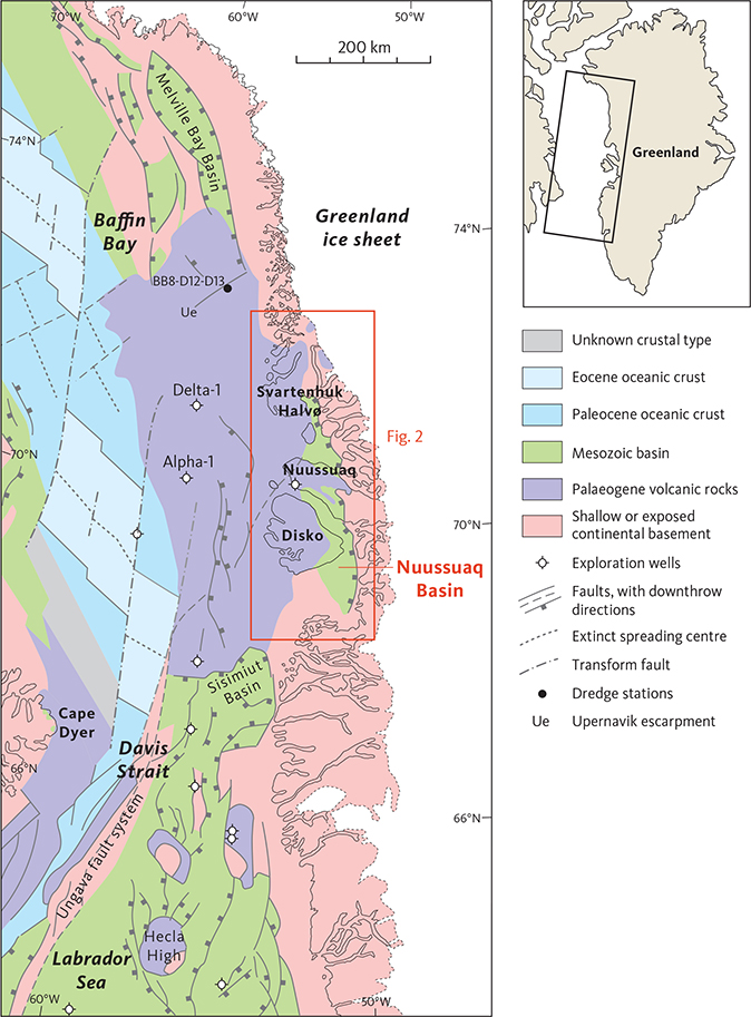
Fig. 1 Simplified geological map showing the regional and tectonic setting of the Nuussuaq Basin in West Greenland. Modified from fig. 1 in Dam et al. (2009) with results from Funck et al. (2012), Oakey & Chalmers (2012) and Gregersen et al. (2019). Dredge stations BB8-D12 and D13 on the Upernavik Escarpment from Polteau & Planke (2008).
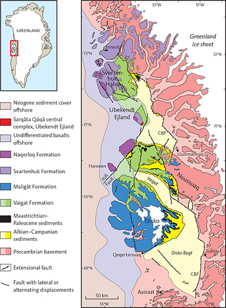
Fig. 2 Simplified geological map of the Nuussuaq Basin. Light colours: sea-covered areas. CBF: Cretaceous boundary fault system.
The volcanic rocks crop out over c. 20 000 km2 within a basinal area of c. 120 km × 400 km (c. 50 000 km2); including the sea-covered areas the volcanic rocks extend over a total area of c. 200 km × 550 km (c. 110 000 km2; Chalmers et al. 1999; Oakey & Chalmers 2012). Offshore, they extend into the Melville Bay Basin in the north and the Sisimiut Basin in the south (Fig. 1).
The volcanic rocks in the Nuussuaq Basin were erupted at highly variable rates into a tectonically very active environment, and there was a complex interplay between the volcanic, sedimentary and tectonic evolution of the basin, which resulted in a complex architecture of the volcanic succession. Moreover, the range of magma compositions was large. West Greenland contains an unusually high proportion of primitive, Mg-rich picritic rocks that represent almost unmodified mantle melts (Drever 1953, 1956; Clarke 1970; Clarke & Upton 1971; Clarke & Pedersen 1976; Holm et al. 1992, 1993; Larsen & Pedersen 2000, 2009). However, repeated episodes of assimilation of crustal material, including organic-rich sediments, led to formation of units of silica-enriched volcanic rocks. On Disko and Nuussuaq these crustally contaminated rocks include native-iron- and graphite-bearing basalts, andesites, dacites and rhyolites (treated in detail by Pedersen et al. 2017, 2018).
The volcanic succession is divided into two major parts. The lower part is dominated by picrites and has been formalised as the Vaigat Formation, which is present from Disko and northwards to Svartenhuk Halvø and Innerit (Figs 2, 3; Hald & Pedersen 1975; Clarke & Pedersen 1976). The upper part is dominated by basalts and has been referred to different formations and members in different areas; according to the most recent dating and correlation by Larsen et al. (2016), the Maligât Formation is present on Disko and on Nuussuaq east of the Itilli Fault, whereas the Svartenhuk Formation is present on Nuussuaq west of the Itilli Fault, on Ubekendt Ejland, Svartenhuk Halvø and the areas farther north and east of this (Figs 2, 3). In this study, a new basalt formation of early Eocene age, the Naqerloq Formation, is established, which is present from Hareøen in the south through western Nuussuaq and Ubekendt Ejland to Svartenhuk Halvø in the north. The volcanic stratigraphy of Hareøen and westernmost Nuussuaq was described by Hald (1976), that of Ubekendt Ejland by Larsen (1977), and that of Disko and Nuussuaq by Pedersen et al. (2017, 2018).
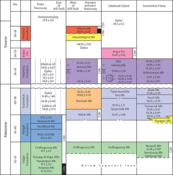
Fig. 3 Stratigraphic scheme and 40Ar–39Ar radiometric ages (in Ma) for the volcanic rocks in the Nuussuaq Basin, modified from Larsen et al. (2016). Radiometric ages with one digit after the decimal point are from Storey et al. (1998) and Larsen et al. (2009), ages with two digits after the decimal point (and no asterisk) are from Larsen et al. (2016) and ages marked with an asterisk are from Chauvet et al. (2019). The age for the Anaanaa Member is not radiometric but based on its normally magnetised character. Note that the vertical ‘age scale’ is not equidistant. Geological units are based on Hald & Pedersen (1975) for Disko and Nuussuaq, Hald (1976) for Hareøen and west Nuussuaq, Larsen (1977) for Ubekendt Ejland, and this study for Svartenhuk Halvø. S.Q.: Sarqâta qáqâ central complex; Kuugaar. Mb: Kuugaartorfik Member; l., m. and u.: lower, middle and upper Nûk takisôq Member, respectively. Sediments with a quartzofeldspathic component are yellow and purely volcaniclastic sediments are brown. Wavy lines indicate unconformities. Narrow black and white columns on the right side of some lithological columns are normal and reversed palaeomagnetic directions, respectively, with magnetochrons indicated; data from Riisager & Abrahamsen (1999), Riisager et al. (1999, 2003), Schmidt et al. (2005), and P. Riisager (unpublished data, 2006).
In this study, we formalise and describe the volcanic stratigraphy of the northern part of the Nuussuaq Basin on Svartenhuk Halvø, including the lavas that flowed across the Cretaceous Boundary fault system to the adjoining areas in the north, north-east and east. The major part of the work was done south of 72°N on Svartenhuk Halvø and the southern part of the Innerit peninsula in connection with mapping for the two 1:100 000 scale geological maps that cover these areas: 71 V.1 Syd Igdlorssuit and 71 V.1 Nord Svartenhuk (Fig. 4). Basalt flows occur as far north as 72°43′N and as far east as 51°54′W (Fig. 5), but north of 72°N and east of 53°40′W, the data coverage is of reconnaissance character only. The extent of the volcanic rocks shown on the published 1:100 000 geological maps 71 V.2 Nord Nûgâtsiaq/Nuugaatsiaq and 72 V.2 Syd Pangnertôq/Pannertooq (Fig. 4) is mainly based on photo interpretation (Henderson & Pulvertaft 1987; Guarnieri et al. 2022a, b). The area north of 72°N and west of 54°W is at present only covered by the 1:500 000 geological map sheet 4 Upernavik Isfjord (Escher 1985).
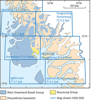
Fig. 4 Index map of geological maps covering Svartenhuk Halvø and the surrounding areas. Maps with names given in both old and new Greenlandic spelling were published 1970–1991 and in revised form in 2022 (Guarnieri et al. 2022 a,b,c). The Prøven and Upernavik maps are in compilation. The Igdlorssuit and Svartenhuk maps (Larsen 1983; Larsen & Grocott 1991) are provided in Supplementary files S1 and S2.
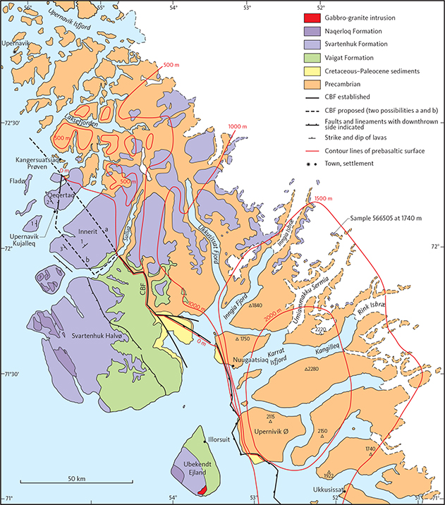
Fig. 5 Geological sketch map of West Greenland between 71° and 73°N. The northern and eastern extent of the volcanic rocks evidently continues farther to the north-east beneath the Greenland ice sheet. The location of the easternmost basalt sample 566505 is shown. The north-western extension of the Cretaceous boundary fault system (CBF) is uncertain and two possibilities are shown, which may both be part of the system. Red contour lines highlight the domal structure and uneven character of the prebasaltic surface; the red numbers are altitudes in m a.s.l.. The lines were constructed from the many closely spaced measurements of the altitude of this surface by Pulvertaft & Larsen (2002, plate 1) and, in the southern part, from the height of the basement peaks.
Previous investigations of the Svartenhuk Halvø area
The earliest scientific descriptions of the volcanic rocks in West Greenland were published by Giesecke (1823; 1910) and Rink (1852) who used the terms “Floetz-trap” or “Trap-formation” and distinguished between “Traptuff” (hyaloclastite), “Basalt-tuff” (pillow breccia), “amygdaloid Basalt” and “columnar Basalt”. The first geological map was produced by Steenstrup (1883) and shows the distribution of basement, sediments and volcanic rocks comprising “Traptuf (Palagonit?)” and “Trap” between 69°10′N and 72°35′N, with the major parts of the inland areas still unmapped.
In the first half of the 20th century, the general geology and structure of the Disko–Nuussuaq–Svartenhuk region was described by Koch (1929). Nieland (1931) described the mineralogy of an anorthoclase-rich trachyte flow from Arfertuarsuk and an olivine basalt dyke from south-east Svartenhuk Halvø and presented probably the first chemical analyses from the area. Rosenkrantz et al. (1942) presented a reconnaissance geological description of Svartenhuk Halvø. A more detailed study of the volcanic rocks of Svartenhuk Halvø was published by Noe-Nygaard (1942), distinguishing for the first time older picrites (“oceanites”) from younger plagioclase-phyric basalts. Noe-Nygaard (1942, p. 67–68) estimated the thickness of the picrite succession exposed along the south coast of Svartenhuk Halvø to more than 10 km, based on the explicit assumption that there are no faults (no faults were observed due to foggy weather on the boat trip along the coast). Major faulting was indeed demonstrated by later workers (Rosenkrantz & Pulvertaft 1969; Münther 1973; Larsen 1983; Larsen & Grocott 1991).
After the Second World War, new expeditions to the area led to increased understanding and detailed knowledge of both the Nuussuaq Basin and the volcanic rocks, see e.g. Pulvertaft & Clarke (1966) and Münther (1973). Early reviews on the stratigraphy, tectonics and structure of the basin were given by Rosenkrantz & Pulvertaft (1969), Henderson (1973) and Henderson et al. (1981). Drever & Game (1948) and Drever & Johnston (1957), working on the picrites on Ubekendt Ejland, were the first to point out that the picrites must represent highly magnesian and very hot magmas. This view was supported by Clarke (1968, 1970), Clarke & Upton (1971) and O’Nions & Clarke (1972) working on Baffin Island and Svartenhuk Halvø.
A comprehensive review of the volcanic rocks of West Greenland was published by Clarke & Pedersen (1976). This review is still essentially correct although many details have been added since then and, in particular, the stratigraphy and geochemistry of the volcanic succession are now much better documented and understood.
The two geological maps at scale 1:100 000 covering Svartenhuk Halvø were published by Larsen (1983) and Larsen & Grocott (1991). The geological basis for the maps was described in a comprehensive unpublished report by Larsen (1981a), and the present volume includes much information contained in that report without further reference to it.
An important paper, to which this study may be seen as complementary, is that of Larsen & Pulvertaft (2000). For the first time, the complicated structure of Svartenhuk Halvø is here described and interpreted in detail, with faulting and tilting of the sedimentary-volcanic succession. The paper also gives short overviews of the lithology of both sediments and volcanics based on Larsen (1981a) and later field work. Consequently, here we only treat the structure of Svartenhuk Halvø briefly and repeatedly refer to Larsen & Pulvertaft (2000).
In recent years, various aspects of the geology of Svartenhuk Halvø have been investigated. Gill et al. (1992) and Holm et al. (1992, 1993) presented petrological, geochemical and isotopic studies; Geoffroy et al. (2001), Abdelmalak et al. (2012) and Chauvet et al. (2019) investigated the structure of the faulted areas; Riisager et al. (2003) made palaeomagnetic profiles through the Vaigat Formation; Dam et al. (2009) established the formal lithostratigraphy of the Cretaceous–Tertiary sediments; Larsen et al. (2016) presented 40Ar/39Ar age determinations, and Agranier et al. (2019) presented geochemical data for a large sample set with a petrological interpretation of the magma genesis for the area.
Geological setting
General geology
The volcanic succession on Svartenhuk Halvø and adjoining areas belongs to the West Greenland Basalt Group (Hald & Pedersen 1975). This group extends onshore over a large area from Disko (69°15′N) in the south to inland areas east of Upernavik (72°43′N) in the north, a distance of nearly 400 km. It extends from the coastal areas and up to 150 km inland where basalt remnants cap the Precambrian basement at altitudes up to nearly 2000 m a.s.l.
The Nuussuaq Basin is bounded towards the Precambrian basement areas in the east by a system of large, deep faults, which run irregularly NNW–SSE and step repeatedly to the west (Fig. 2). These are referred to as the Cretaceous boundary fault system (Larsen & Pulvertaft 2000). This fault system runs through Svartenhuk Halvø and divides it into two parts: the Cretaceous–Tertiary basin in the west and the Precambrian basement covered by basalts in the north and east (Figs 2, 5, 6).
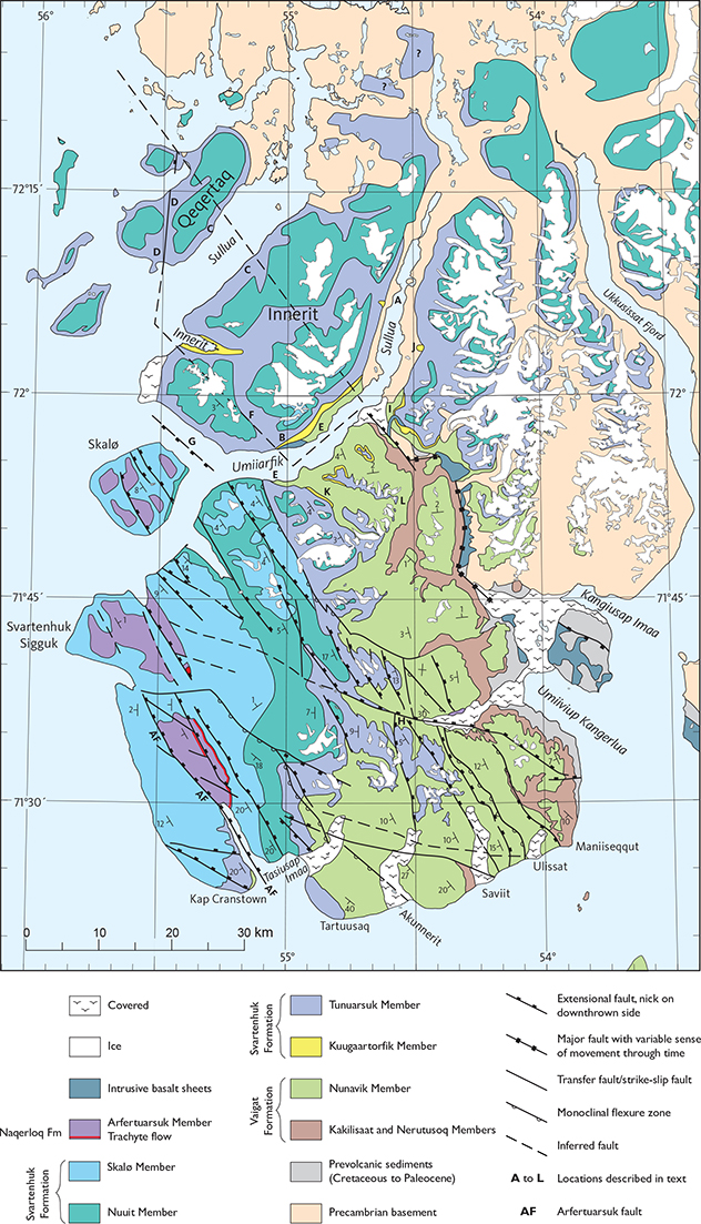
Fig. 6 Geological map of Svartenhuk Halvø and the northern volcanic areas. Geology south of 72°N after Larsen & Pulvertaft (2000, fig. 2). North of 72°N, the extent of the volcanic rocks is from Escher (1985); the boundary between the Tunuarsuk and Nuuit Members is extrapolated from the existing geological map south of 72°N, combined with the six sampled profiles north of 72°N (see Fig. 9), the nearly unfaulted and flat-lying state of the succession with a dip of c. 1°NW and the topographic map. Remnants of the Skalø Member are also present on several summits east of Sullua (Guarnieri et al. 2022a, b) but are mainly concealed beneath the ice. See Fig. 7 for place names mentioned in this study.
The Precambrian basement in the northern area considered here consists of Archaean and Proterozoic gneisses overlain by Proterozoic metasediments and metavolcanics of the Karrat Group (e.g. Grocott & Pulvertaft 1990; Thrane 2021; Guarnieri et al. 2022c). In the north, these rocks are cut by a large intrusion, the Prøven igneous complex, also of Proterozoic age (e.g. Escher 1985; Thrane et al. 2005). The surface of the Precambrian basement forms a broad, dissected dome with maximum altitudes around 2200 m east–north-east of Ubekendt Ejland, from where the surface slopes c. 1°NW and reaches sea level north of Innerit and Qeqertaq. This dome structure was first observed by Rink (1852, p. 20). From its maximum, the dome surface also slopes eastwards down to about 1500 m altitude before it disappears beneath the Greenland ice sheet (Fig. 5; Pulvertaft & Larsen 2002). The prevolcanic surface is uneven and constitutes a pre-Paleocene etch surface with irregular hilly relief (Fig. 5; Pulvertaft & Larsen 2002; Bonow 2005; Bonow et al. 2006), which has at least partly been covered by the basalts. The highest preserved basalt cover is at c. 1950 m altitude in the Umiammakku Sermia – Kangilleq area (Fig. 5; Pulvertaft & Larsen 2002). Any original basalt cover in the central dome area with altitudes above 1700–1950 m has been removed by erosion.
The south-western part of the area considered here, i.e. the northern Nuussuaq Basin area, comprises much of Svartenhuk Halvø and is dominated by volcanic rocks, which rest on Cretaceous–Paleocene sediments of the Nuussuaq Basin (Figs 2, 6). The prevolcanic sediments are exposed in the eastern part of Svartenhuk Halvø and have been described in overview by Larsen & Pulvertaft (2000). Dam et al. (2009) referred them to the Albian–Cenomanian Upernivik Næs Formation (deltaic sandstones interbedded with mudstones), the Turonian–Campanian Itilli Formation (marine mudstones), and the Maastrichtian–Danian Kangilia Formation (mudstones with conglomerates). Dam & Sønderholm (2021) reviewed the tectonostratigraphic evolution of the Nuussuaq Basin during the Cretaceous and Palaeogene with five phases of repeated rifting and faulting with concomitant sedimentation and finally breakup and volcanism.
The oldest exposed volcanic rocks in the Svartenhuk Halvø area are silicic basalts and picrites of the Vaigat Formation, which are correlated with the upper part of the Vaigat Formation on Nuussuaq and Disko (Fig. 3). Older parts of the Vaigat Formation may be present below exposure level to the west and to the south of Svartenhuk Halvø, but it is also likely that the volcanism of the Vaigat Formation spread gradually northwards from Nuussuaq. In any case, volcanism in the Nuussuaq Basin was well on its way at the time when the oldest volcanic rocks now exposed on Svartenhuk Halvø were deposited.
Offshore, the volcanic succession continues on the shelf south, west and north-west of Svartenhuk Halvø (Fig. 1) where seismic investigations have shown the presence of a volcanic package up to several kilometres thick (Whittaker 1996; Skaarup 2002; Skaarup & Pulvertaft 2007; Gregersen et al. 2013, 2019). Gregersen et al. (2013, fig. 5) pointed out a close connection between the onshore and offshore volcanic successions, and drilling and dredging have provided sample material. Basalt samples from the 2017 m volcanic succession in the drill hole Alpha-1 (location in Fig. 1) are compositionally similar to basalts from the Svartenhuk Formation (L.M. Larsen, unpublished data, 2011), and samples from the 1137 m volcanic succession in the drill hole Delta-1 (location in Fig. 1) are both compositionally and age-wise similar to basalts from the Naqerloq Formation (Nelson et al. 2015). Samples dredged on the Upernavik escarpment (Fig. 1) are compositionally similar to basalts from the Svartenhuk Formation (Polteau & Planke 2008).
Structures
Basin area
In the basin south-west of the Cretaceous boundary fault system, the sedimentary-volcanic succession is heavily faulted, as described and analysed in detail by Larsen & Pulvertaft (2000). Prevolcanic faulting, uplift, downthrow and erosion in the basin area and along the boundary fault system is indicated by the fact that the volcanic rocks were deposited onto sediments ranging in age from Turonian to Paleocene; moreover, the sediments contain conglomerates and fanglomerates with basement clasts, some of which are cyclic. Locally the sediments show folding, which may be caused by gravity slumping or perhaps postvolcanic faulting (Larsen & Pulvertaft 2000, p. 12). Contemporaneous, interdigitating sediments and volcanic rocks are only found in a few places on south-eastern Svartenhuk Halvø (Larsen & Pulvertaft 2000, p. 12–13).
Syn- and particularly postvolcanic faulting is evident almost everywhere in the basin on Svartenhuk Halvø. Numerous postvolcanic extensional faults trending NW–SE have divided the area into a number of rotated fault blocks with SW-dipping strata with different dips (Fig. 6; Larsen & Pulvertaft 2000, figs 2, 9 and p. 23). Dips are smallest in the north-eastern and northern areas (2°–10°) and increase to 10°–45° south of some WNW–ESE-trending transfer faults. The largest fault is the NW–SE-trending Arfertuarsuk fault that runs through the Arfertuarsuk inlet in the south to Svartenhavn in the north (Fig. 6; names on Fig. 7) with a downthrow of the north-eastern block of at least 2 km at its south-eastern end (Larsen & Pulvertaft 2000, p. 24). Therefore, the youngest part of the succession is found on the north-eastern side of the Arfertuarsuk fault (Fig. 6) where the basalts dip 15–23°SW or more, and north thereof where the basalts dip only 0–10°. South-west of the Arfertuarsuk fault the Vaigat Formation reappears at Narsinganersua (Kap Cranstown) together with the older parts of the Svartenhuk Formation.
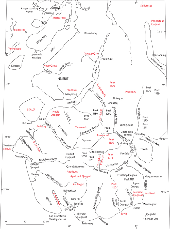
Fig. 7 Place names used in the text. Names in red are also profile names; their numbers are shown in Fig. 8.
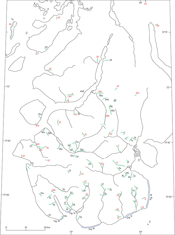
Fig. 8 Locations and numbers of all studied profiles through the volcanic succession. Profiles with red numbers are mentioned in the text and their names shown in Fig. 7. Most of these profiles are shown as vertical schematic ‘logs’ in Figs 10–13, and their coordinates are listed in Appendix 1.
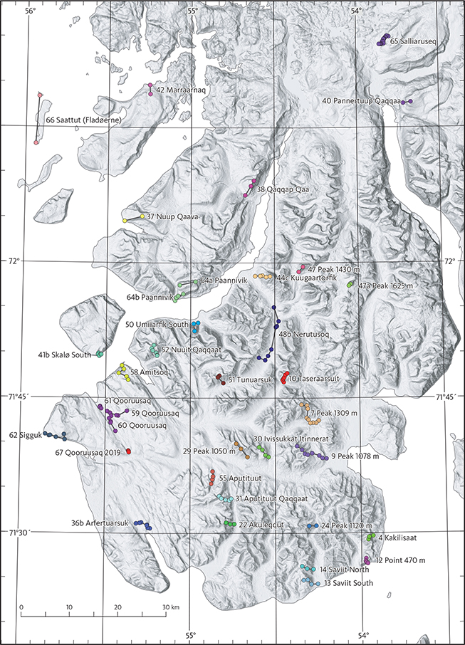
Fig. 9 Digital elevation model (from the Greenland Ice Mapping Project) of Svartenhuk Halvø with locations of the most important profiles such as type and reference sections. Dots are measured points along the profile lines, and colours distinguish individual profiles. See text for detailed explanations. Coordinates are in Appendix 1 and in digital form in Supplementary file S3.
Northern extension of the Cretaceous boundary fault system
North of Svartenhuk Halvø, the Cretaceous boundary fault system is difficult to follow across the Innerit peninsula and Qeqertaq because of the largely unfaulted lava pile that has transgressed it. The most easterly possible location of the continuation of the boundary fault north of 72°N is along a SE–NW line running from the coast on south-eastern Innerit across Innerit and Qeqertaq, skirting a small exposure of basement at Itillia, and continuing out to sea in a nearly straight line (line a in Fig. 5). Another possibility is that the fault turns south-west in the Umiiarfik fjord between Svartenhuk Halvø and Innerit, then turns north-west and crosses southern Innerit to southern Qeqertaq, then turns north along a fault line there, and then out to sea (line b in Fig. 5). This position would explain some of the structures mentioned below (Locs D, E and F in Fig. 6). The anomaly pattern on the aeromagnetic map of Rasmussen (2002) makes a still more westerly position of the Cretaceous boundary fault system less likely.
Northern and eastern areas
East of the Cretaceous boundary fault system on Svartenhuk Halvø, the volcanic rocks resting on the high Precambrian basement are unfaulted and have a low average dip of 2.3°WNW (Larsen & Pulvertaft 2000). This is close to the overall slope of the prevolcanic basement surface, which dips 1.5°W to 2.1°WNW between Siuteqqut Kuuat and Kangiusap Aaffaa. The maximum preserved thickness is 1300 m beneath the 1700 m high mountain Siuteqqut (Fig. 7).
The volcanic succession north of 72°N is nearly flat-lying and with few exceptions unfaulted. In the western part of the area, the base of the lava pile is below sea level, and to the east, the lavas rest on the Precambrian basement that rises from sea level to an altitude of 2000 m close to the Greenland ice sheet. The overall dip of the lava succession here is around 1°NW to W, similar to the dip of the pre-basaltic basement surface.
In the following we describe some structural features in addition to those south of 72°N, which were treated by Larsen & Pulvertaft (2000). Locs A to G are shown in Fig. 6.
Loc. A. A prebasaltic, N–S-trending fault is presumably situated in Sullua fjord east of the Innerit peninsula. This is suggested from a jump in surface altitude of the basement across the fjord from 500 m a.s.l. on the eastern side to close to sea level on the western side of the fjord. The lava successions in the profiles 38 and 39 on the opposite fjord sides (Fig. 8) roughly correlate across the fjord with the elevation differences caused by the regional dip of 1°W of the lava pile.
Loc. B. There are indications of synvolcanic subsidence in the southern Innerit peninsula just east of the Paannivik profile (64, Fig. 8), where the lower part of the Tunuarsuk Member dips 4–6°SW with gradually decreasing dip up-section to 2°SW in the upper part and to 1°SW at the boundary between the Nuuit and Skalø Members on Paannivik, see dip measurements on the geological map of Larsen & Grocott (1991).
Loc. C. There is a weak anticline on the north-west coast of Innerit and the south-east coast of Qeqertaq, which could be a primary structure of a low lava shield.
Loc. D. One of the rare post-basaltic faults in the northern area crosses Qeqertaq with a direction close to N–S and a 25 m downthrow to the west. This fault appears to form the boundary between 1°NW-dipping basalts to the east and 1–2°SW-dipping basalts to the west and may reflect the position of the buried Cretaceous boundary fault system, which must run out to sea immediately north-west of Qeqertaq (Fig. 5, line b). The lavas on Tukingasoq island also dip 1–2°SW whereas the lavas on Kigataq island dip c. 2°W.
Loc. E. Structural analysis of the boundary between the Vaigat and Svartenhuk Formations across Umiiarfik fjord indicates uplift (inversion) of the Svartenhuk Halvø side relative to Innerit, suggesting a hidden fault in Umiiarfik (Larsen & Pulvertaft 2000, p. 22). This fault could be part of the Cretaceous boundary fault system (Fig. 5, line b).
Loc. F. A concealed NW–SE-trending fault crosses southern Innerit. This is seen from the change in dip of the lavas across this line from 1°NW to 3°SW southwest of it, indicating a kink in the lava package. NW-trending dykes are common south of the line and rare north of it. This fault could also be part of the Cretaceous boundary fault system (Fig. 5, line b).
Loc. G. A postvolcanic fault probably trending NW–SE must be present in the sound between Innerit and Skalø, as indicated by the different dips of the lava packages on Innerit (3°SW) and eastern Skalø (close to 0°). The lava package on Skalø is downthrown c. 500 m relative to that on Innerit. This fault may be connected to the large flexure zone that runs through Svartenhuk Halvø from the south-east coast to the north-west coast (Fig. 5), with subsidence to the west of 600 m in northern Svartenhuk Halvø (Larsen & Pulvertaft 2000).
Methods
Field work, sample profiles and map compilation
This study is based on geological mapping by J.G. Larsen in 1974, 1976, 1980 and 1983, in 1983 together with T.F.D. Nielsen, and on geological mapping by K.A. Jørgensen in 1981. It is also based on earlier works, particularly by T.C.R. Pulvertaft, as described in Larsen & Pulvertaft (2000). Supplementary sampling was done by various field parties of the Geological Survey of Denmark and Greenland (GEUS) in the period 2009–2019. During mapping, the logging and sampling were preferentially done in traverses at locations where the stratigraphy was relatively undisturbed by faulting, although some profiles have been pieced together from shorter sections. Flow-by-flow sampling was applied when possible. Mapping and location of profiles and samples were done on aerial photographs on a scale of c. 1:40 000, and altitudes were measured with a traditional altimeter. Samples from 2009 and later were located and their altitudes measured with GPS (Global Positioning System). In total, 67 numbered and named profiles were measured and described in the field but not all of these were also sampled. The place names mentioned here are shown in Fig. 7 and the locations of all profiles are shown in Fig. 8.
About 1800 samples of mainly lava flows, hyaloclastites, intrusions and sediments were collected. Some of the most important and best sampled profiles are designated stratigraphic type and reference sections. For this study, these and some additional profiles mentioned in the text were located on the EOX Sentinel-2 cloudless satellite image data set available on the Greenland Portal (https://maps.greenmin.gl/geusmap/?mapname=greenland_portal). For each profile, the UTM (Universal Transverse Mercator) coordinates for the start and end points and some intermediate points were read. Altitudes were subsequently obtained from the Greenland Ice Mapping Project digital elevation model from NASA’s National Snow and Ice Data Center (Howat et al. 2014). This data set has a resolution of 30 × 30 m, and as most profiles are situated on relatively steep mountain sides, the obtained heights are only moderately accurate. The geographical coordinates and altitudes and the digital elevation map showing the locations of these profiles (Fig. 9) were provided by Christian Brogaard Pedersen (GEUS). Their coordinates and approximate altitudes are given in Appendix 1 and in digital form in Supplementary file S3.
The digital elevation model in Fig. 9 gives an impression of the topography of the area; of particular notice are the mountainous areas separated by wide valleys with little or no exposure. A low-lying area seen in central western Svartenhuk Halvø presents a combination of poor exposures, faulting and steep and variable dips of the fault blocks; in this area some geological boundaries are only tentative or not placed at all, e.g. the boundary between the Nuuit and Skalø Members.
The most important sampled and analysed profiles are presented as vertical columns in Figs 10–13. The heights are m a.s.l., which deviate from true thicknesses in dipping successions; dips and strikes are therefore given below each profile. All the long and well-sampled and analysed profiles are included in the figures, whereas short and unsampled profiles are not.
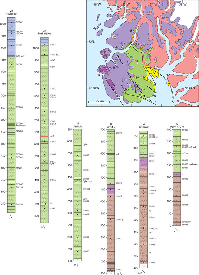
Fig. 10 Profiles through the volcanic succession in southern Svartenhuk Halvø. Vertical scale is m a.s.l. as measured. Dip and strike of the succession are shown below each profile. Legend in Fig. 13. Locations in Fig. 9 and coordinates listed in Appendix 1.
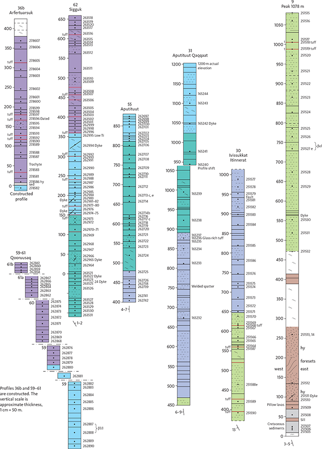
Fig. 11 Profiles through the volcanic succession in central and western Svartenhuk Halvø. Vertical scale is m a.s.l. as measured except for profiles 36b and 59–61. Dip and strike of the succession are shown below each profile. Legend in Fig. 13. Index map in Fig. 10. Locations in Fig. 9 and coordinates listed in Appendix 1.
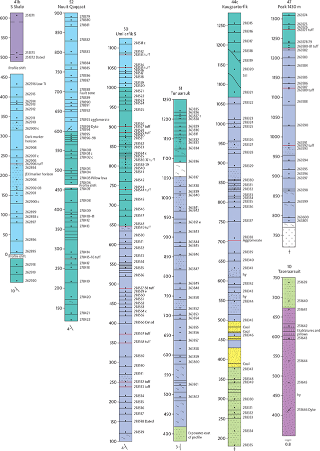
Fig. 12 Profiles through the volcanic succession in northern Svartenhuk Halvø. Vertical scale is m a.s.l. as measured. Dip and strike of the succession are shown below each profile. Legend in Fig. 13. Index map in Fig. 10. Locations in Fig. 9 and coordinates listed in Appendix 1.
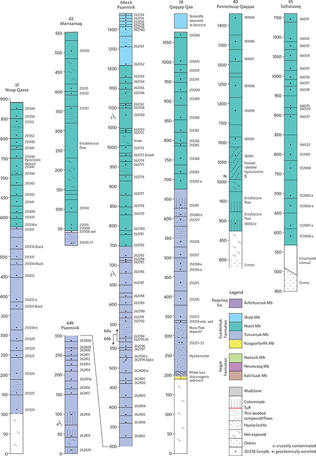
Fig. 13 Profiles through the volcanic succession north of Svartenhuk Halvø. Vertical scale is m a.s.l. as measured. In all profiles except Paannivik, the succession is near-horizontal, dipping 2° or less. Index map in Fig. 10. Locations in Fig. 9 and coordinates listed in Appendix 1. The legend applies to Figs 10–13. Definitions of ‘crustally contaminated’ and ‘geochemically enriched’ in the Nomenclature section. volc. sed.: volcanogenic sediment.
The south and east coasts of Svartenhuk Halvø present a well exposed section through most of the volcanic stratigraphy in the area. The coastal exposures were photographed from the sea, and the photographs (diapositives) were subsequently projected onto a screen and traced by hand to produce pen drawings of five coastal sections (multi-model photogrammetry was not available at the time). The sections are shown in coloured versions in Figs 14–18. Their positions are indicated on Fig. 8. Due to complicated faulting and poor exposures, it was not possible to construct a similar picture of the part of the south coast between Akunnerit and Saviit.
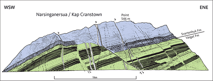
Fig. 14 The coastal section at Narsinganersua (Kap Cranstown). Location in Fig. 8. The faulted lava flows dip c. 20°SW. The succession comprises 280 m of the uppermost Nunavik Member of the Vaigat Formation and a similar thickness of the lowermost Tunuarsuk Member of the Svartenhuk Formation. Solid black lines denote groups of massive picrite flows that highlight the complicated fault structure. The dotted line is a tuff layer. The apparent low-angle fault in the centre of the section is a WNW–ESE-trending fault that cuts obliquely through the exposure (Fig. 6); it is partly intruded by a dyke. Vertically hatched flows are massive, plagioclase-phyric flows: the lowest flows in the Tunuarsuk Member and a single basalt flow in the Nunavik Member. The thickest dykes are indicated by Ds. Hand traced from colour slides projected onto a screen and therefore not with constant horizontal and vertical scales. See also photo in Fig. 34.
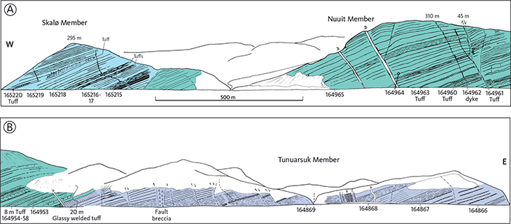
Fig. 15 Section along the north coast of Tasiusap Imaa, 15–20 km north-east of Kap Cranstown and east of the large fault in Arfertuarsuk fjord. Location in Fig. 8. A: western part. B: eastern part. All three volcanic members of the Svartenhuk Formation are present. The faulted lava flows dip c. 20°WSW. Groups of thin pahoehoe flows are shown with bed-parallel hatching, and tuff layers are dotted. Note the 20 m thick tuff at the boundary between the Tunuarsuk and Nuuit Members. The thickest dykes are indicated by Ds. Samples and observations along the shore are indicated; analyses are in Supplementary file S4. Hand traced from colour slides projected onto a screen and therefore not with constant horizontal and vertical scales.
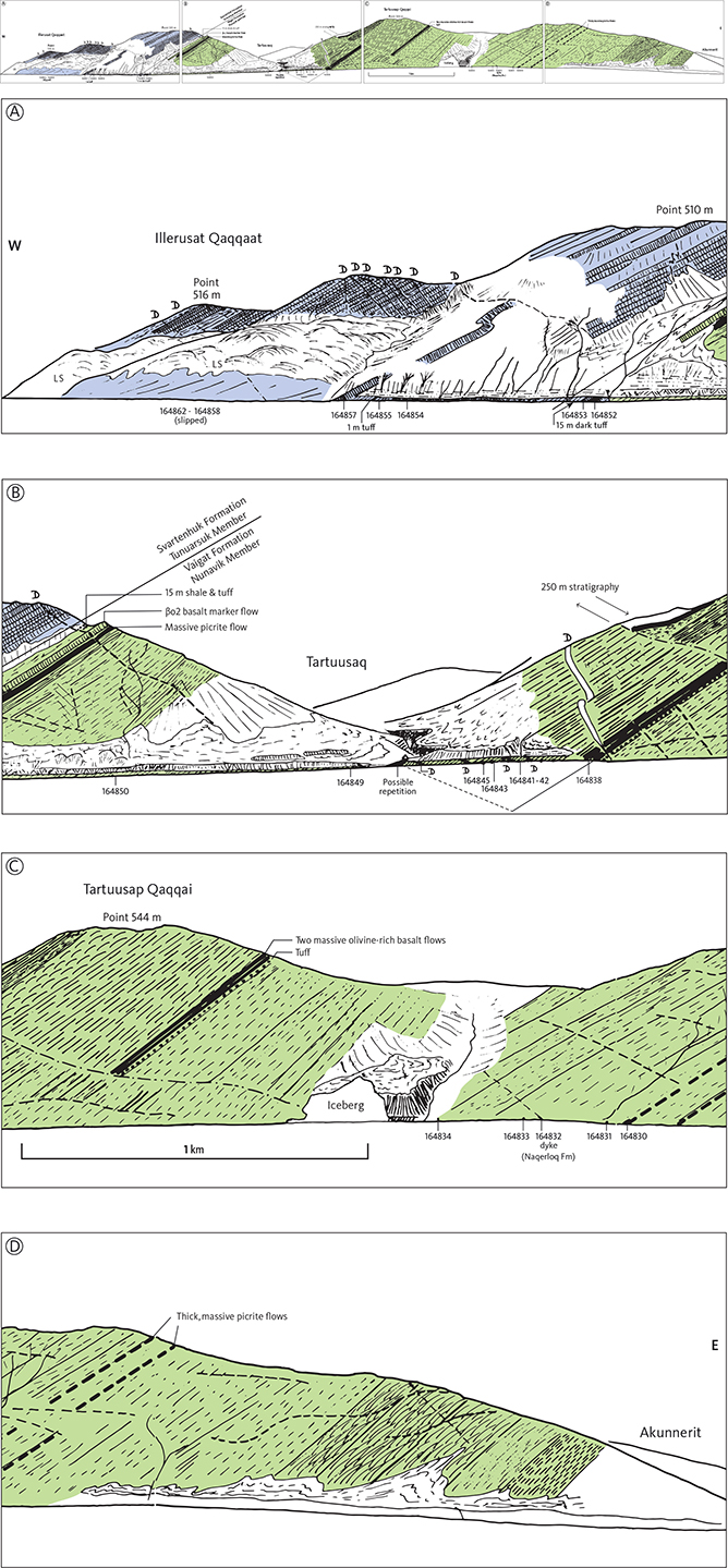
Fig. 16 Section along the south coast of Svartenhuk Halvø from Illerusat Qaqqaat to Akunnerit. Location in Fig. 8. The four panels should be read from west to east in the succession A, B, C and D. The faulted lava flows dip 30–40°SW. C and D show c. 2 km of unfaulted succession between the iceberg and Akunnerit, which is the thickest unfaulted succession encountered in the Vaigat Formation, without exposed top and base. Groups of thin pahoehoe flows are shown with different bed-parallel hatchings, massive picrite flows are black and massive basalt flows vertically hatched. βo2 is a mapped basalt marker flow near the top of the Vaigat Formation. Note the thick shale and tuff at the boundary between the Vaigat and Svartenhuk Formations. The thickest dykes are indicated by Ds. LS: landslide. Samples along the shore are indicated; analyses are in Supplementary file S4. Hand traced from colour slides projected onto a screen and therefore not with constant horizontal and vertical scales.
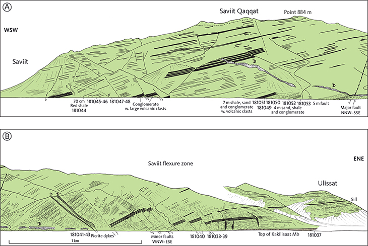
Fig. 17 Section along the south coast of Svartenhuk Halvø from Saviit to Ulissat. Location in Fig. 8. A: western part. B: eastern part. The succession comprises the lower part of the Nunavik Member. The top of the underlying Kakilisaat Member is just exposed on the shore in B. Panel B contains a cross section of the large flexure zone (here called the Saviit flexure zone) that runs NNW–SSE across the peninsula (Fig. 6) and was described in detail by Larsen & Pulvertaft (2000, p. 27–28). East of the flexure zone, the lava flows are nearly horizontal; within the zone, a series of WNW–ESE strike-slip faults with block rotation have resulted in westerly dips increasing towards the west to more than 40°WSW. West of the flexure zone, the lava flows are faulted but dip fairly regularly only 10–15°WSW. The WNW–ESE faults are near-vertical but appear here to be inclined towards ENE, which is an effect of the topography and the direction of view. The total offset produced by the faulting is impossible to calculate because of the lithological uniformity of the Nunavik Member and lack of reliable marker horizons. Groups of thin pahoehoe flows are shown with bed-parallel hatching, and massive picrite flows are black. The thickest dykes are indicated by Ds. Samples and observations along the shore are indicated; analyses are in Supplementary file S4. Hand traced from colour slides projected onto a screen and therefore not with constant horizontal and vertical scales.
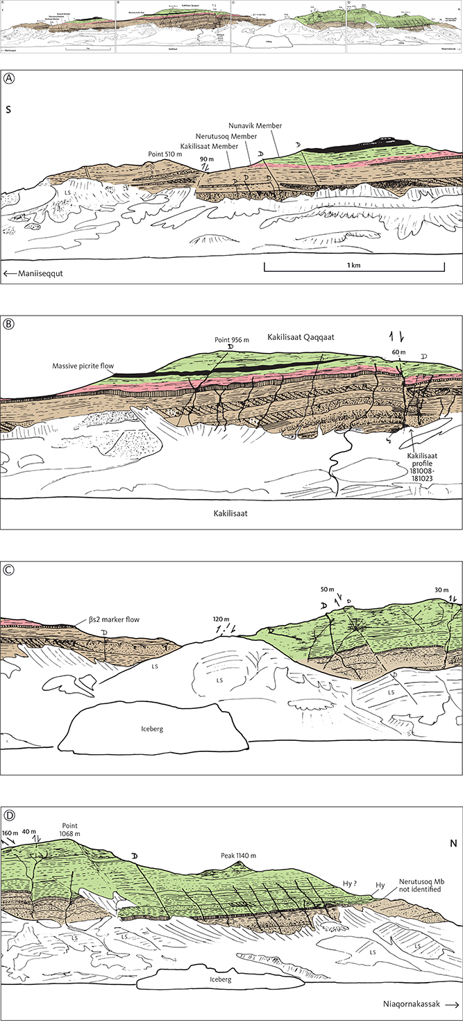
Fig. 18 Section along the east coast of southern Svartenhuk Halvø from Maniiseqqut in the south to Niaqornakassak in the north. Location in Fig. 8. The four panels should be read from south to north in the succession A, B, C, and D. The succession comprises the Kakilisaat and Nerutusoq Members and the lower part of the Nunavik Member, all belonging to the Vaigat Formation. The Kakilisaat Member contains three hyaloclastite horizons (Hy) of which the upper two are foreset-bedded with N-dipping foresets. In the north, the Nunavik Member contains one or two hyaloclastite horizons, also foreset-bedded with N-dipping foresets. The solid black flow is a massive picrite flow. The vertically hatched flow is a massive basalt flow (βs2) that forms the top of the Kakilisaat Member. The position of profile 4 (Kakilisaat) is indicated; it ascends just north of a fault scarp and continues along the mountain ridge to Point 956 m. See also Figs 10, 21. The thickest dykes are indicated by Ds. LS: landslide. Hand traced from colour slides projected onto a screen and therefore not with constant horizontal and vertical scales.
The volcanic parts of the two geological maps at scale 1:100 000 covering Svartenhuk Halvø were compiled by J.G. Larsen using the 1:40 000 vertical aerial photographs, which were also used in the field. The Igdlorssuit map sheet was compiled with a Sketch Master, whereas for the Svartenhuk map sheet, the low-lying parts were compiled with a Sketch Master and the mountanous and difficult areas with a Kern PG2 stereo plotter. The Precambrian basement areas of the Svartenhuk map were compiled in a similar way by J. Grocott.
Geochemistry
Almost all major-element analyses presented here are by X-ray fluorescence spectrometry (XRF) and were made by Jørgen Kystol and Ib Sørensen at the rock geochemical laboratory at the Geological Survey of Greenland (GGU)/GEUS with analytical procedures as described by Kystol & Larsen (1999). Most elements were determined by XRF on fused glass discs with sodium tetraborate flux; Na2O was determined by atomic absorption spectrometry, and FeO by potentiometric titration.
A subset of samples was analysed for trace elements by Jørgen Kystol and Olga Nielsen at GEUS using a PerkinElmer Elan 6100 DRC Quadrupole Inductively coupled Plasma Mass Spectrometer (ICP-MS). Sample dissolution followed a modified version of the procedure used by Turner et al. (1999) and Ottley et al. (2003). Calibration was done using two certified rare-earth element (REE) solutions and three international reference standards with reference values from Govindaraju (1994) supplemented with newer values for the REE from the GeoReM database (http://georem.mpch-mainz.gwdg.de). Results for reference samples processed and run simultaneously with the unknowns are normally within 5% of the reference value for most elements with concentrations >0.1 ppm.
Nearly all samples were ground in a tungsten carbide ball mill. This has introduced small amounts of Co and Ta into the powders. We estimate that 5–15 ppm Co has been added to the natural contents of 40–100 ppm Co, which does not conceal the natural variations. The amount of Ta added is mostly very small but may be significant in the picrites where the natural contents of Ta are only about 0.2 ppm.
Samples with numbers higher than 278607 had major elements analysed at the University of Edinburgh. All trace elements were analysed at GEUS except for samples 572001–572008, which were analysed at Actlabs Laboratories, Vancouver.
In total, about 900 samples were analysed for major elements and 300 for trace elements. From the Vaigat Formation, 166 samples were analysed for major elements and 48 for trace elements. From the Svartenhuk and Naqerloq Formations, 720 samples were analysed for major elements and 233 for trace elements. Twenty dyke samples were analysed for major elements and 14 for trace elements. All analytical data are available in Supplementary file S4.
In the chemical variation diagrams shown here, the elements have been recalculated to 100 wt% on a volatile-free basis. Samples with more than 7 wt% volatiles were as a rule not plotted and not analysed for trace elements. All mg-numbers and CIPW normative compositions given are calculated with Fe2O3/FeO adjusted to 0.15.
Nomenclature
The definition of igneous rock types is based on the Total-Alkalis-Silica (TAS) chemical classification of Le Maitre (2002) supplemented by a few extra terms. Picrites have MgO ≥12 wt% (Le Maitre 2002); we use ‘magnesian basalts’ for basalts with 10–12 wt% MgO, which are usually visibly olivine-phyric. ‘Silicic basalts’ have slightly increased SiO2 = 51–52 wt% and have presumably been slightly crustally contaminated, as uncontaminated basalts in the region rarely have more than 51 wt% SiO2. Rocks with SiO2 >52 wt% are basaltic andesites.
We identify rocks, which are contaminated with continental crustal material by their elevated contents of SiO2, K2O, Rb, Ba, Th, U, light REE and Pb, and low MgO, CaO, TiO2, FeO* (total iron as FeO), V, Cu and Ni relative to common mantle-derived rocks (Larsen & Pedersen 2009; Pedersen et al. 2018). High SiO2, K2O and Rb and low Nb are particularly diagnostic.
The term ‘geochemically enriched’ is applied to rocks with elevated contents of a number of incompatible elements such as P, Ba, Th, U, Nb, Zr, Sr, and the light REE relative to common mantle-derived tholeiitic basaltic rocks. High P, Nb and Sr are particularly diagnostic.
Pahoehoe lava flows are commonly thin and highly vesicular, particularly in their upper part. Their crust is smooth, with ropy and sometimes glassy top zones. Thin pahoehoe flows usually come in groups of flow lobes formed during the same eruption episode, and such groups are called compound lava flows (Walker 1971). Thick, massive flows with relatively thin and smooth flow tops are here called sheet flows following e.g. Self et al. (1997) and Sheth (2018). Lava flows of aa type are also thick and massive but have thick, highly scoriaceous top zones. On Svartenhuk Halvø, there is a morphological range between typical pahoehoe sheet flows and aa flows, but typical aa flows are rare.
Subaqueous lava flows are thick flows that commonly display various kinds of columnar jointing; they are usually brecciated in their upper part and capped by yellowish brown hyaloclastite; their top zones do not show red oxidation. Other fully or partly subaqueous flows are pillow lavas with pillows with glassy rims.
Entablature lava flows have tiers with a basal colonnade with vertical columns overlain by entablature zones showing irregular and fan-shaped columnar jointing. They are formed by emplacement into shallow water.
The lithological terms ‘hyaloclastite’ and ‘pillow breccia’ are frequently used synonymously. Following White & Houghton (2006), we use hyaloclastite as a general term to denote primary clastic subaqueous volcanic deposits. However, we frequently use ‘pillow breccia’ for coarse, clast-rich deposits even though these may include finer-grained clast-poor parts. The term ‘volcaniclastic’ is used as a nongenetic term to denote any clastic deposit with a large component of volcanic material, including both primary volcanic and nonvolcanic deposits such as mass-flows and other redeposited sediments.
Vaigat Formation
History. The presence of very olivine-rich volcanic rocks in the lower part of the volcanic succession in the West Greenland volcanic province has been known since the pioneering work by Steenstrup (1883). The olivine-rich succession was formalised as the Vaigat Formation by Hald & Pedersen (1975) with distribution throughout the province from Disko to Svartenhuk Halvø, and with its type area on the north coast of Disko between Kuugannguaq and Asuk.
The descriptions in the following are only concerned with the Vaigat Formation in the Svartenhuk Halvø area.
Synonymy. The ‘lower basalt series’ of Münther (1973); the ‘lower formation’ of Larsen (1981a, b) and Holm et al. (1993).
Subdivisions. The Vaigat Formation on Svartenhuk Halvø is divided into three members, from bottom to top:
Kakilisaat Member: brown to grey, silica-enriched, crustally contaminated basalts, basaltic andesites and a few picrites.
Nerutusoq Member: brown basalts and magnesian basalts enriched in incompatible elements.
Nunavik Member: grey picrites and magnesian basalts.
The Kakilisaat and Nerutusoq Members are combined into one unit on the geological maps because they cannot be visually distinguished from a distance in the field or on photographs. At close range the two members are distinguishable because the Kakilisaat Member comprises both plagioclase-phyric and aphyric rocks whereas all the Nerutusoq Member rocks are aphyric.
Distribution. The Vaigat Formation is exposed in the southern, eastern and north-eastern parts of Svartenhuk Halvø and the south-eastern part of the Innerit peninsula (Figs 6, 19). South-east of Svartenhuk Halvø the formation extends to the islands Schade Øer (Qeqertat). In the southern part of the peninsula the volcanic pile is faulted and the lavas dip SW (Figs 14–17); in its western part the Vaigat Formation is covered by the Svartenhuk Formation and disappears below sea level (Figs 14, 16). The westernmost exposure is on the southern tip of Qinnivik (Kap Cranstown) where the upper part of the Vaigat formation is exposed (Fig. 14). The oldest exposed part of the Vaigat Formation is situated in the eastern basinal area (Fig. 18) immediately west of the Cretaceous boundary fault system. Farther to the east, the formation has overstepped the Cretaceous boundary fault system; here it rests on the Precambrian basement and is overlain and overstepped by the Svartenhuk Formation. The Vaigat Formation presumably extends at depth beneath south-western Svartenhuk Halvø and beneath the sea to the south and west. Seismic sections in the sea south of Svartenhuk Halvø and west of Ubekendt Ejland show a thick package of faulted, W-dipping strata interpreted as lava flows of the Svartenhuk Formation (Skaarup & Pulvertaft 2007). The volcanic succession is most probably much thicker than the c. 800 m thickness, which is visible above the first sea-bed multiple, making the presence of the Vaigat Formation at depth entirely possible.
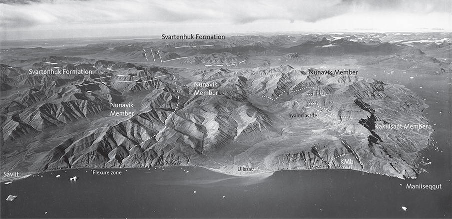
Fig. 19 The south coast of Svartenhuk Halvø between Saviit and Maniiseqqut (location in Fig. 7). The Vaigat Formation (Kakilisaat and Nunavik Members) is strongly and repeatedly faulted, and the lavas dip up to 40°W. Dashed white lines: upper limit of hyaloclastite horizons. Dotted white line: Upper boundary of the Kakilisaat Member (KMb). Full white lines: boundary between the Vaigat and Svartenhuk Formations. Geodetic Institute oblique aerial photograph 526DN/9465.
Type section. The type section is composed of five individual sections situated close to the coasts of the Vaigat strait (Pedersen et al. 2017, p. 26).
Reference sections. On Svartenhuk Halvø, Kakilisaat (profile 4) covers the Kakilisaat and Nerutusoq Members and the lowermost Nunavik Member. Peak 1078 m (profile 9) covers the main part of the Nunavik Member, and Peak 1309 m (Profile 7) covers the top part of the Nunavik Member and the boundary to the Svartenhuk Formation.
Thickness. In a swathe of land just west of the Cretaceous boundary fault system, the Vaigat Formation is exposed from bottom to top, dips are less than 5° and faulting is minimal so that thicknesses there can be reliably estimated. In the northern and central parts of this area, thicknesses of 950–1250 m are present, increasing southwards from Simiuttap Kuua to Peak 1309 m northwest of Firefjeld. Farther south the formation is at least 1250 m thick with no upper boundary preserved. At Saviit Qaqqaat close to the south-east coast the thickness may have been as much as 1500–1700 m, obtained by extrapolation from thicknesses in the northern part of the basin towards the southern area using a slope of 1° of the lava pile (see the later section on marker horizons in the Nunavik Member). Overall, thicknesses within the basin increase from north to south. The thickness of the subaerial part of the lava pile increases southwards from 200–300 m on Innerit, through 450 m in north-central Svartenhuk Halvø (at Peak 1250 m), to 600 m in east-central Svartenhuk Halvø (at Peak 1309 m).
On the Precambrian basement, the thickness is reduced to c. 500 m in the Qinngusaaq area, and the formation thins out at a height of 1100 m east of Siuteqqut.
The greatest thickness of the Vaigat Formation is presumed to be present in southern Svartenhuk Halvø. Unfortunately, this is an area where faulting and tilting are severe and prohibit the entire thickness of the formation to be measured in any one profile (Figs 16, 17). The thickest unfaulted succession encountered in the Vaigat Formation is c. 2 km without exposed top and base, found on the south coast west of Akunnerit (Fig. 16). Despite good exposures along the south coast of the peninsula the crumbling and monotonous character of the lithologies in many places make repetitions due to faulting very difficult to detect. Noe-Nygaard’s (1942) estimated thickness of more than 10 km, ignoring any repetitions due to faulting, is definitely too high. The estimate was reduced to at least 8 km by Pulvertaft & Clarke (1966) and to 2.5–3 km by Münther (1973). Larsen & Pulvertaft (2000) estimated a thickness in the order of 4–4.5 km taking the known repetitions into account. Until more studies have been made, we can only conclude that the formation is at least up to more than 2000 m and perhaps up to 3000 m thick.
Lithology. The lower part of the formation comprises brown to grey hyaloclastites and pillow lavas with subordinate lava flows comprising brown, aphyric and plagioclase-phyric, Si-enriched, contaminated basalts, magnesian basalts and subordinate picrites of the Kakilisaat Member, overlain by brown, aphyric, trace-element-enriched basalts of the Nerutusoq Member (Fig. 18). Subaerial lava flows dominate at the south coast west of Ulissat.
In the lowermost part of the formation minor thin, intervolcanic, tuffaceous and coarse volcaniclastic sediments, sand-, silt- and mudstones are present, e.g. on Uparuaqqusuitsut (Larsen 1981a; Dam et al. 2020), south of Qorlortoq, on Firefjeld and in Usuit Kuussuat.
The upper part of the formation is composed of mostly greenish grey picrites and magnesian basalts of the Nunavik Member. These form hyaloclastites and overlying subaerial pahoehoe lava flows in the eastern part of the basin.
Boundaries. The lower boundary of the Vaigat Formation is the base of the volcanic succession, and the basal lithology is most commonly hyaloclastite. Within the basinal area the volcanic succession rests on sediments of Cretaceous and Danian/Selandian age (Larsen & Pulvertaft 2000; Dam et al. 2009, p. 30), but contacts are rarely exposed. A conformable relation between Paleocene sediments and the volcanic rocks has been observed in a few places. On the eastern slope of Firefjeld, the hyaloclastites rest on a Paleocene conglomerate that itself overlies Cretaceous mudstones (Larsen & Pulvertaft 2000; Dam et al. 2009, pp. 90 and 115). In south-eastern Svartenhuk Halvø, a small exposure on the western bank of the river in Ulissat Qooruat, 5.5 km north of Ulissat (shown on the geological map of Larsen 1983), shows an ochre-coloured quartzofeldspathic sandstone overlain by black to dark green tuff and dark sandstone with molluscs and ophiomorphae burrows indicating a marine environment, overlain by hyaloclastites (Larsen & Pulvertaft 2000, p. 13). A conformable transition to hyaloclastites also appears to be present on top of Itsaku. Interbedded mudstones and hyaloclastites occur along the south-west side of the valley of Qorlortup Kuua and at Issiallak. In other exposures within the basin area prevolcanic tectonic uplift and erosion have removed the upper Campanian – Maastrichtian and lowermost Paleocene sediments.
East of the Cretaceous boundary fault system, almost all Mesozoic–Paleocene sediments pre-dating the volcanism have been removed as a result of prevolcanic uplift and erosion. Here, the upper part of the Vaigat Formation rests directly on elevated Archaean gneisses and Proterozoic metasediments with a substantial surface topography. The lowest volcanic rocks are most commonly hyaloclastites. North of Kangiusap Imaa, the Vaigat Formation dominantly consists of hyaloclastites up to 270 m thick, situated at altitudes up to more than 1210 m, the highest level for the hyaloclastites in the Vaigat Formation, caused by postvolcanic uplift.
The upper boundary is marked by the first occurrence of brown, olivine-poor basalts of the Svartenhuk Formation or, in the northern area, the first occurrence of yellow, quartzofeldspathic sand beds with mudstones and coal seams. The boundary is placed at the base of the sediments because these are interbedded with the basal lava flows of the Svartenhuk Formation and were presumably deposited during an uplift of the basement rocks east of the Cretaceous boundary fault system associated with the earliest eruptions of the Svartenhuk Formation. In the southern area, no erosion has been recorded to indicate a longer break in the volcanism before the eruption of the Svartenhuk Formation. However, a sediment/tuff horizon is commonly present at the boundary, for example at Tartuusaq (Fig. 16) and Aputituut Qaqqaat (profile 31, Fig. 11).
The highest altitude of the upper boundary is close to 1300 m and is found at Peak 1309 m within the basin in central eastern Svartenhuk Halvø. The same altitude of the upper boundary is found on the basement near Qinngusaaq 12 km north-east of Peak 1309 m (Larsen & Grocott 1991). This shows that the inversion of the basinal area noted by Münther (1973) and Larsen & Pulvertaft (2000, p. 22) is differential with the largest altitude differences in the north, decreasing towards the south-east.
Geological age. Paleocene (Danian to Selandian). A marine sandstone–tuff–mudstone succession underlying the base of the volcanic succession in Ulissat Qooruat has provided an Early Paleocene age: The tuffaceous rocks yielded a dinoflagellate cyst assemblage, which belongs to the Deflandrea striata zonule (Hansen 1977, 1980, p. 92), now the Cerodinium striatum interval biozone referred to the upper part of the Lower Paleocene (middle NP4, Powell 1992), corresponding to an age of around 62 Ma according to Gradstein et al. (2004) and subsequent time scale revisions. Chauvet et al. (2019) obtained a 40Ar/39Ar age of 61.08 ± 0.56 Ma for a basalt flow from the lowest part of the Vaigat Formation at the eastern south coast of Svartenhuk Halvø.
The upper age limit of the Vaigat Formation is not well constrained. It is estimated to be about 60–61 Ma based on the radiometric (40Ar/39Ar) ages for basalts low in the overlying Tunuarsuk Member of the Svartenhuk Formation (between 60.3 ± 1.4 Ma and 59.4 ± 0.6 Ma, Larsen et al. 2016) and an intervening hiatus indicated by a sediment horizon in the northern area.
Radiometric (40Ar/39Ar) dating of the Vaigat Formation in the Disko–Nuussuaq area (Storey et al. 1998) yielded ages of 61–62 Ma ± 0.5–1 Ma, similar to and slightly older than the radiometric age obtained by Chauvet et al. (2019) for the Vaigat Formation on Svartenhuk Halvø. The entire Vaigat Formation was probably deposited within a relatively short time interval (Storey et al. 1998; Pedersen et al. 2002).
Age constraints from palaeomagnetic results are described in the section on correlation below.
Correlation. Palaeomagnetic investigations have shown that the lower part of the Vaigat Formation on Nuussuaq is normally magnetised in magnetochron C27n (Riisager & Abrahamsen 1999), the upper boundary of which is placed at 62.2 Ma (Vandenberghe et al. 2012; Speijer et al. 2020). Two palaeomagnetic profiles covering almost the entire lava succession of the Vaigat Formation on Svartenhuk Halvø show reversed magnetisation (C26r) throughout (Riisager et al. 2003, 2004). Also the aeromagnetic pattern of the volcanic areas shows a reversed signature (Rasmussen 2002). This indicates that the Vaigat Formation on Svartenhuk Halvø correlates with the upper part of the Vaigat Formation in the Disko–Nuussuaq area as shown in Fig. 3. The palaeomagnetic profiles are located on the southern flank of Kakilisaat Qaqqaat and the eastern side of Peak 1309 m (profile 7, Fig. 9).
Kakilisaat Member
New member
History. On the geological map 71 V.1 Syd Igdlorssuit (Larsen 1983) the Kakilisaat Member is combined with the overlying Nerutusoq Member and shown as the units βp, βf1 and βf2. On the geological map 71 V.1 Nord Svartenhuk (Larsen & Grocott 1991), the Kakilisaat and Nerutusoq Members are shown as the units βp, βp1, βs1 and βs2. See the two maps provided in Supplementary files S1 and S2. The name Kakilisaat Member was used by Larsen & Pulvertaft (2000) with the same meaning as here, but the member was not formally defined.
Name. After Kakilisaat Qaqqaat, a 956 m high mountain on the coast of south-eastern Svartenhuk Halvø where the member is well developed.
Distribution. The Kakilisaat Member is present in south-eastern Svartenhuk Halvø and the eastern south coast. It is also present on Qeqertat (Schade Øer) south-east of the peninsula. Very similar and perhaps correlative rocks occur as far south as the south coast of Ubekendt Ejland. The member is covered by younger units to the west as a result of the general westerly dip of the lava pile (Fig. 20). The member reappears on the south coast west of the river delta at Saviit as a result of a major repetition caused by faulting (Fig. 6).
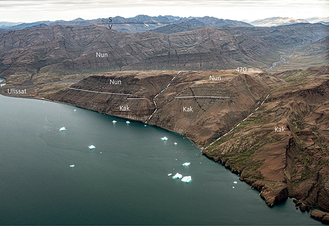
Fig. 20 Faulted lava flows of the Kakilisaat (Kak) and Nunavik (Nun) Members of the Vaigat Formation in southeasternmost Svartenhuk Halvø, looking north-west (compare Fig. 19). The Nerutusoq Member is presumed to be present but is unsampled (profile 12, Fig. 10). The wide valley running across the picture is Ulissat Qooruat. Beyond this, grey crumbling lava flows of the Nunavik Member dip westward. In the far background, dark lava flows of the Svartenhuk Formation (S) overlie grey flows of the Vaigat Formation (V). Photo: Kristian Svennevig.
The extension of the member north of Firefjeld is uncertain because, as already mentioned, it cannot be distinguished from the overlying Nerutusoq Member from a distance. The absence of the capping βs2 lava flow north of Firefjeld and at Peak 1309 m (Larsen & Grocott 1991) suggests that the northward progradation of the Kakilisaat Member flows stopped here, but this does not exclude that subaquous eruption products could be present farther to the north beneath the Nerutusoq Member. The Kakilisaat Member may thus be present in the lowermost hyaloclastite unit along the west side of the valley of Siuteqqut Kuuat. Other possible occurrences include small hyaloclastite remnants on the top of Itsaku and on the mountain slope north-west of Itsaku; chemical data from these areas are not available. Nowhere is the Kakilisaat Member seen to overstep the Cretaceous boundary fault system (see also Fig. 26).
Type section. Kakilisaat (profile 4, Fig. 10) in south-eastern Svartenhuk Halvø, in a gully on the east side of the 956 m high mountain Kakilisaat Qaqqaat, between 420 and 820 m altitude. Coordinates in Appendix 1. The profile follows the northern side of a fault where the base of the member is covered by scree (Figs 18, 21). However, an additional 50 m is exposed near the base of the member, resting on Cretaceous sediments at 280 m altitude on the east slope of Ulissat Qooruat 3 km south-west of the fault.
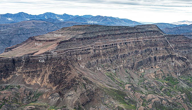
Fig. 21 The three members of the Vaigat Formation in the east wall of the mountain Kakilisaat Qaqqaat, south-east Svartenhuk Halvø, looking north-west. The Kakilisaat Member (Kak) comprises alternating horizons of hyaloclastites (hy) and subaerial lava flows (La), whereas the Nerutusoq (Ner) and Nunavik (Nun) Members solely comprise subaerial lava flows. Foreset-bedding in the hyaloclastites dips north. A fault is indicated by the dash-dot line. The type profile for the Kakilisaat Member runs uphill just north of the fault and then southwards along the plateau to the summit at 956 m. Height of exposed mountain wall c. 560 m (400–956 m). Note large masses of slipped material at the foot of the wall. Photo: Kristian Svennevig.
Reference sections. Saviit South (profile 13, Fig. 10) west of Saviit; this comprises c. 450 m of subaerial lava flows of the Kakilisaat Member and includes two picritic lava flows at the base of the profile. Peak 1078 m (profile 9, Fig. 11) south-west of Firefjeld below c. 420 m altitude; this includes about 200 m of hyaloclastites at the base, resting on Cretaceous heterolithic mudstones. Coordinates in Appendix 1.
Thickness. A thickness of more than 450 m of lava flows is present along the south coast west of Saviit where the base of the member is not exposed. A thickness of 400 m of hyaloclastite and lava flows is found in the type section at Kakilisaat Qaqqaat; there are more than 400 m of hyaloclastite and lava flows in the northern part of Ulissat Qooruat, and 300 m or more of hyaloclastite and lava flows west of Firefjeld. Thicknesses decrease to 270–200 m of hyaloclastite capped by a few lava flows on the northern slopes of Issiallaap Qaqqaa, to 170 m of hyaloclastite on southern Firefjeld and to only 150 m of hyaloclastites and lava flows along the southern side of eastern Usuit Kuussuat (Fig. 7; see also Fig. 26). The rather large variation in thickness was at least partly caused by block faulting of the bedrock prior to the extrusion of the member.
Lithology. The Kakilisaat Member is composed of hyaloclastites, pillow lavas and subaerial lava flows of thin pahoehoe and thicker sheet flow types. The member is dominated by basalts and basaltic andesites with brownish weathering colours, but there are also a few magnesian basalts and picrites. The rocks are plagioclase ± olivine-phyric and aphyric; a few carry orthopyroxene phenocrysts. The sheet flows have a distinct brown colour, whereas the thin pahoehoe flows are brownish grey to greenish grey for the more MgO-rich types. The low-viscous magmas of the pahoehoe flows gave rise to well-bedded (foreset-bedded) hyaloclastites, whereas the more viscous magmas of the thicker sheet flows produced weakly bedded hyaloclastites and pillow lavas. It is the distinct, brown sheet flows and their associated brown hyaloclastites that make the member identifiable in the field. The hyaloclastite beds range from 40 m to more than 200 m in thickness, whereas the pahoehoe lava sequences may form up to 60 m thick compound flows; the sheet flows are 10–30 m thick. Black mudstones up to several metres in thickness are locally interbedded with the basal subaqueous volcanic deposits. Sediment xenoliths are present in a picritic hyaloclastite in a gully on the northern west side of the valley of Qorlortup Kuua at c. 71°46′20″N, 54°20′30″W.
Subaerial and subaqueous facies of the member show regional variations, with subaerial lava flows dominating in the south and south-west. Towards the north, the subaerial lava flows transform to hyaloclastite facies with a general north-dipping foreset-bedding. Thus the lavas flowed northwards, overriding their prograding hyaloclastites, possibly from a topographical high established close to the eruption sites in the southern area and farther south (see Fig. 26). The topmost brown lava flows including the βs2 marker flow (Larsen & Grocott 1991) reached as far north as south-west of Firefjeld before they entered the water, and north of this the entire member is in hyaloclastite facies. The basin in the north presumably formed a fault-bounded trough along the eastern part of the basin. Along the south side of Usuit Kuussuat, a hyaloclastite bed prograded eastwards from dry land in the west (Larsen 1981a, fig. 14).
Subaerial and subaqueous lava facies are interbedded in the area of the type profile at Kakilisaat Qaqqaat (Fig. 21). The type profile is composed of three eruptive units each consisting of thick, foreset-bedded pillow breccias overlain by pillow lava and pahoehoe lava flows. Each unit reflects an episode of filling of a basin with a water depth of 35–80 m, indicating basin subsidence between each episode. The north-dipping hyaloclastite foresets also here indicate filling from south towards north (Fig. 22). Upwards in the profile the hyaloclastites decrease in thickness and the proportion of subaerial lava flows increases. Towards the west the amount of hyaloclastite also decreases, and west of Ulissat the entire succession is subaerial as in the Saviit South profile (Fig. 10).
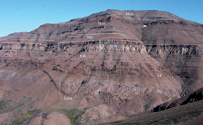
Fig. 22 The three members of the Vaigat Formation on the western slope of the mountain Kakilisaat Qaqqaat, south-east Svartenhuk Halvø. The lowest exposure is the uppermost hyaloclastite horizon (hy) in the Kakilisaat Member (Kak); the north-dipping foresets showing the direction of progradation are clearly visible. The hyaloclastites are capped by their associated subaerial lava flows (La). The two uppermost flows in the Kakilisaat Member with white and brown weathering colours (βs2) are recognisable also in Fig. 21. The thin brown flows of the Nerutusoq Member (Ner) are poorly exposed. The normally grey Nunavik Member (Nun) contains a massive brown lava flow, which is an MgO-poor picrite. Height of exposure c. 500 m. Photo: Asger Ken Pedersen.
Near Maniiseqqut, the south-easternmost point of Svartenhuk Halvø, and on Schade Øer 15–25 km south of Maniiseqqut, spectacular pillow lavas, pillow breccias and pillow-rich hyaloclastites are exposed and easily accessible along the shores (Figs 23–25).
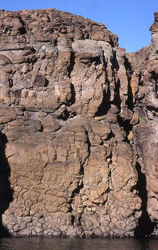
Fig. 23 Pillow lava with close-lying pillows up to 1 m in diameter developed in the lower part of the flow. The middle part shows flow banding and the upper part is rubbly due to abundant vesicles. Height of exposure c. 20 m. Kakilisaat Member, eastern south coast of Svartenhuk Halvø near Maniiseqqut. Photo: Asger Ken Pedersen.
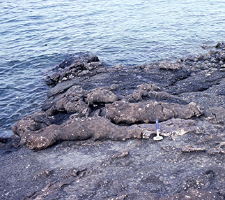
Fig. 24 Elongate pillows reminiscent of seals on the shore. Kakilisaat Member, Schade Øer, south of eastern Svartenhuk Halvø. Length of hammer 29 cm. Photo: Asger Ken Pedersen.
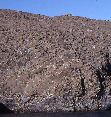
Fig. 25 Pillow breccia with abundant, up to metre-sized pillows, pillow fragments and lava fragments in a glass-rich matrix. Kakilisaat Member, eastern south coast of Svartenhuk Halvø near Maniiseqqut. Height of the vertical part of the cliff c. 15 m. Photo: Asger Ken Pedersen.
The rocks on Schade Øer show weak but significant oil staining. An oil seep, several localities with oil staining as well as carbonate veins with oil are also found on the south-eastern shores of Svartenhuk Halvø, particularly near Maniiseqqut (Christiansen et al. 1998, 2000). It appears that the lithologies of the Kakilisaat Member are particularly favourable for trapping of migrating oil.
Sediments, commonly poorly exposed, are found within the member at several localities.
Several metres of shaly sediments including gritty layers occur in the lower part of the member at Issiallak below the brown breccia and on top of an olivine-phyric hyaloclastite (71°35′26″N, 54°14′32″W, c. 175 m a.s.l.).
On the north-eastern part of Firefjeld between 390 and 510 m a.s.l., three hyaloclastite layers each about 40 m in thickness are interbedded with and overlain by shaly mudstone and intruded by a sill at 510 m a.s.l.
A 0.5 m thick shale layer with plant remains and intruded by a basalt sill is present within the brown hyaloclastite in the southern south-west side of the valley of Qorlortup Kuua at c. 300 m a.s.l., and another 0.5 m thick shale layer with a white surface colour is present on top of the brown hyaloclastite at 337 m a.s.l (71°43′53″N, 54°14′35″W). The latter can be followed towards the north-west due to its white surface colour. It may correspond to a 1.5 m thick shale horizon between the brown and the grey hyaloclastites c. 14 km farther south on the northern flank of Issiallaap Qaqqaa, as reported by S. Munck in Rosenkrantz et al. (1942, p. 49, where the mountain was misnamed as Umîviup qáqai).
In the upstream part of the valley of Qorlortup Kuua, on the south-western valley side, a 5 m thick silty shale layer is present between an aphyric basaltic hyaloclastite with sediment inclusions and an overlying olivine-phyric hyaloclastite with a loose shale layer on top. The top of the basaltic hyaloclastite appears to be chilled against the sediment, indicating it is intrusive (71°46′23″N, 54°19′34″W, c. 165–184 m a.s.l.).
On the north-west side of Simiutaq by Simiuttap Kuua two sedimentary beds at 300–400 m a.s.l. were noted but not visited. They may perhaps correlate with those described here, but could also belong to the overlying Nerutusoq Member.
Eruption sites. There is clear evidence from the dip directions of the foreset-bedding in the hyaloclastites and the general stratigraphy that the lava flows of the south-eastern area flowed north and east from a central area around Ulissat Qooruat and Usuit Kuussuat, indicating that eruption sites should be present in the southern part of the peninsula and probably also farther south (Larsen 1981b; Fig. 26). Eruptions may have occurred over most of the area occupied by the member because dykes with similar appearance and composition are found at several localities within the member. One eruption site was identified on the lower eastern flank of Peak 1309 m where numerous closely spaced small dykes or thin lava sheets cut the hyaloclastites (Fig. 26; Larsen 1981a, fig. 16).
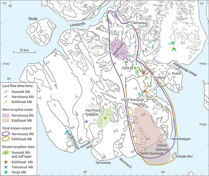
Fig. 26 Map showing flow directions as indicated by dips of foreset-bedding in hyaloclastites of the Vaigat Formation and the main eruptive areas and total known extents of the Kakilisaat and Nerutusoq Members. The coloured area at Nerutusoq is the ‘table mountain’ with subaerial lava flows described in the text. Both members probably continue below exposure level to the west. The Kakilisaat Member may also be present farther north than shown. The Nunavik Member is considered to extend across the entire area. Also shown are known eruption sites for the volcanic succession.
A local eruption site somewhere east of Peak 1078 m presumably emitted lavas flowing westwards where they changed into hyaloclastite facies south-east of Peak 1078 m (profile 9). A dyke in profile 9 with a chemical composition corresponding to that of the Kakilisaat Member is probably part of the feeder system for these flows (Fig. 26).
Chemistry and chemostratigraphy. The rocks of the Kakilisaat Member are dominantly silicic basalts and basaltic andesites; a few picrites extend the total MgO range to 6–13 wt% MgO. Relative to the normal rocks of the Nunavik Member most of the rocks have elevated contents of SiO2 and K2O and low MgO, CaO, TiO2 and FeO* (total iron as FeO). The elevated contents of SiO2, K2O and many trace elements suggest that the rocks have been crustally contaminated (see the earlier Nomenclature section and the later Geochemistry chapter); the presence of sediment xenoliths in the rocks supports this suggestion. Representative analyses are given in the Geochemistry chapter.
No clear evolution trend with time can be seen in the TiO2 contents, whereas the MgO content tends to decrease upwards but with the uppermost basalts being more magnesian again.
Boundaries. The lower boundary is identical to that of the Vaigat Formation within the basin, and the sediments underlying the Kakilisaat Member include marine Paleocene mudstones and black, tuffaceous material. The earliest volcanic rocks in the region were therefore deposited in a marine basin.
The upper boundary is placed at the top of the uppermost of two massive brown marker lava flows underlying the grey picrites along the south-east coast of Svartenhuk Halvø; in some areas one of these lava flows may have a white colour due to zeolite-filled cracks (Fig. 22). These brown lava flows are designated βf1 on the 1:100 000 Igdlorssuit map sheet (Larsen 1983) and βs2 on the 1:100 000 Svartenhuk map sheet (Larsen & Grocott 1991). Note that the contaminated basalts below βf1 are not distinguished from the picrites on the Igdlorssuit map sheet. In the area west of Saviit other brown lava flows form the top of the member.
In the field, distinction between the Kakilisaat and Nerutusoq Members is difficult based on lithology alone. However, the occurrence of interspersed plagioclase-phyric and aphyric rocks is indicative for the Kakilisaat Member basalts, whereas the Nerutusoq Member basalts are all aphyric. Definitive distinction between the two members requires chemical analyses; the Nerutusoq Member rocks have lower SiO2 and higher CaO than the Kakilisaat Member rocks and different trace-element patterns (see the Geochemistry chapter).
Geological age. Paleocene (Danian to Selandian). The Kakilisaat Member is reversely magnetised and was erupted during magnetic polarity chron C26r (Riisager et al. 2003). Its age is thus constrained to the interval 62.2–61 Ma, based on the lower age boundary of C26r and the upper age boundary of the Vaigat Formation. Chauvet et al. (2019) presented an 40Ar/39Ar age of 61.08 ± 0.56 Ma in accordance with this for a silicic basalt lava flow from the lower part of the Vaigat Formation at the eastern south coast of Svartenhuk Halvø. The location and chemical composition of the basalt (Agranier et al. 2019, their Site 42) indicate that it belongs to the Kakilisaat Member.
Correlation. The Kakilisaat Member is suggested to be time-correlated with the crustally contaminated Tunoqqu and Kûgánguaq Members of the Vaigat Formation on Nuussuaq and Disko (Fig. 3). All were erupted within a period when the conditions for high-level magma storage and reaction with crustal rocks were favourable.
Nerutusoq Member
New member
History. On the geological maps of Larsen (1983) and Larsen & Grocott (1991) the member is combined with the underlying Kakilisaat Member because the two members can only be visually distinguished at close range. The name Nerutusoq Member was first used by Larsen & Pulvertaft (2000) in the same sense as here, but the member was not formally defined.
Name. After the large, NNE–SSW-oriented inland valley Nerutusoq in northern Svartenhuk Halvø (Figs 7–9).
Distribution. The member is present in the northern part of Svartenhuk Halvø along the valley of Nerutusoq (Fig. 27; see also Larsen & Pulvertaft 2000, plate 1, profile C–D) and around the Simiutaq hill. It is also present in the short valley that extends W–E from just north of the lake Taseraarsuit around 71°47′N, 54°25′W to the valley of Siuteqqut Kuuat (see also Fig. 40). The member is inferred to be present in the valley of Siuteqqut Kuuat, exposed on the western valley side close to the Cretaceous boundary fault system, and also in the broad area around Firefjeld. The member is present in south-eastern Svartenhuk Halvø, where a few flows have been identified in profiles 4 and 13 at Kakilisaat and Saviit South (Fig. 10). The extension of the member to the west, north-west and north is unknown.
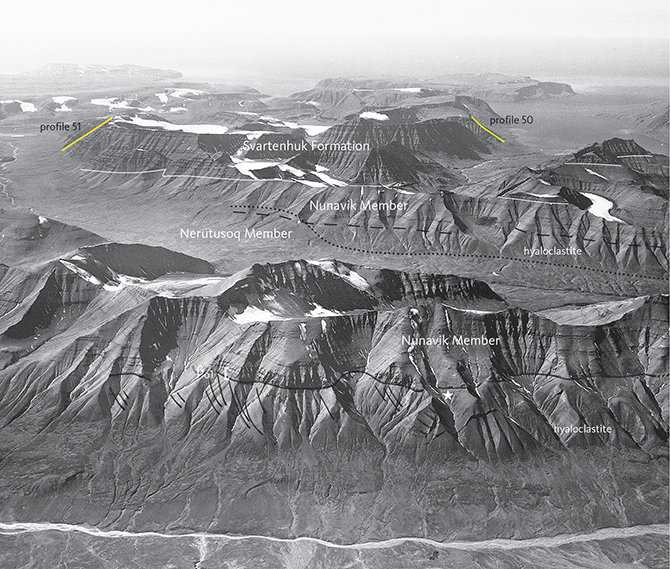
Fig. 27 The Vaigat Formation west of the Siuteqqut Kuuat valley, looking west. In the foreground subaerial thin pahoehoe lavas of the Nunavik Member overlie 300 m of associated hyaloclastites with large-scale foreset-bedding indicating volcanic progradation to the north (enhanced by drawn, black lines). The marker unit βo1 with dark flows is indicated by a white [; the unit disappears into hyaloclastite facies at the position of the white star. In the middle ground is the wide Nerutusoq valley. In its western mountainside lavas and hyaloclastites of the Nerutusoq Member are exposed in a small area on the low slope, overlain by the Nunavik Member. The dashed black line is the upper boundary of the hyaloclastite facies; the facies boundary crosses the member boundary (dotted black line). In the distant mountains thick-bedded lava successions of the Svartenhuk Formation overlie the Nunavik Member above the white line. Profiles 50 (Umiiarfik south) and 51 (Tunuarsuk) are indicated with yellow lines. Geodetic Institute oblique aerial photograph 524CV/8298.
Type section. Nerutusoq (profile 48b) in the northern part of Svartenhuk Halvø along the Nerutusoq valley (Figs 7–9, 27, coordinates in Appendix 1). No vertical profile such as those in Figs 10–13 could be constructed because a major part of the profile is near-horizontal, although it is up-section through inclined hyaloclastites.
The lower boundary of the member is placed on top of Cretaceous sediments c. 100 m a.s.l. at the south-eastern end of Simiuttap Kuua, just west of the hill Simiutaq. The profile follows the eastern riverside in the Nerutusoq valley 10.5 km southward until a gully in the western valley side, which is then followed uphill (Fig. 28). Most of the profile transects SW-dipping hyaloclastites, but in the gully these are capped by brown aphyric basalt flows at 595 m a.s.l. (Fig. 28). At 670 m a.s.l. the brown basalts are overlain by thin grey pahoehoe flows of the Nunavik Member. Here the exposure is downwarped along a NW–SE fault and dips to the south. On the north-eastern side of the fault the boundary is horizontal with an elevation of 750 m a.s.l..
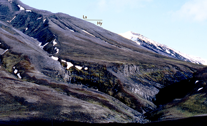
Fig. 28 The middle part of the type profile (48b, Fig. 9) for the Nerutusoq Member. The location is where the profile leaves the riverbed in the main valley and climbs uphill through a gully in the hyaloclastites (Hy) and into the subaerial lava succession (La). Western slope of the southern Nerutusoq valley, central Svartenhuk Halvø.
The lower boundary in the type profile was not visited in the field, and therefore we cannot know if the lower part of the section includes brown hyaloclastites of the Kakilisaat Member. The lowest analysed sample (GGU 263818) in the type profile is from 360 m altitude in a small drainage stream c. 2.8 km north-west of Peak 1250 m. The undifferentiated βp hyaloclastite of the map sheet (Larsen & Grocott 1991) reflects the uncertainty concerning the field distinction between the Kakilisaat and Nerutusoq Members (see the description of the boundaries of the Kakilisaat Member).
Reference sections. Taseraarsuit (profile 10) on the south-west side of Peak 1140 m, 2–3 km north of lake Taseraarsuit (Figs 7–9, 12; coordinates in Appendix 1). At 350–670 m a.s.l., this profile is mostly well exposed and presents 320 m of the upper part of the member, including 240 m of hyaloclastites, 40 m entablature flows, 40 m fully subaerial, thin lava flows and the boundary to picrite lava flows of the overlying Nunavik Member. A second reference section is Kakilisaat (profile 4) in south-eastern Svartenhuk Halvø. At 825–860 m a.s.l. the Nerutusoq Member here has a strongly reduced thickness of only 35 m of subaerial lava flows without a significant break in the volcanism (Figs 10, 18).
Thickness. An estimated maximum thickness of up to 650 m may be present in the southern part of the Nerutusoq valley, dependent on the absence or presence of the Kakilisaat Member beneath it and the topography of the bedrock. With the same reservations, the thickness in the northern part of Nerutusoq is about 300 m. Towards north-west along the south-west side of the valley of Simiuttap Kuua the thickness decreases from 300 m to 100 m. Near lake Taseraarsuit the thickness is more than 230 m, and along the west side of the valley of Siuteqqut Kuuat the member is inferred to be present with a thickness of more than 200 m. The member is strongly reduced in thickness to the south-east and south, where it is 60 m thick at Kakilisaat (profile 4) and 40 m thick at Saviit South (profile 13).
Lithology. The Nerutusoq Member is composed of brown aphyric basalts and magnesian basalts forming hyaloclastites and pillow lava tongues, which in places are capped by an up to 50 m thick succession of subaerial, thin, vesicular pahoehoe lava flows. The lowermost lava flows were emplaced into shallow water and are entablature lavas with irregular and fan-shaped columnar jointing and an uneven top topography; the flow tops have a dark brown colour and are presumably glass-rich.
In the southern part of the Nerutusoq valley, the member consists of southerly dipping hyaloclastites capped by lava flows at altitudes of 720–750 m. This succession can be followed northwards on the western valley side; 2 km farther north the brown lava flows have all transformed into hyaloclastites, which dip northwards below hyaloclastites of the overlying Nunavik Member at altitudes of 720–400 m, decreasing northwards. The hyaloclastites of the two members appear to interdigitate (see cross-section in Larsen & Pulvertaft 2000, plate 1, profile C–D). The two members were erupted at a time with similar water levels, at least partly contemporaneously, and thus formed hyaloclastites up to the same altitude of 720 m, covered by lava flows. A similar situation exists in the valley of lake Taseraarsuit where more than 250 m of east-dipping, brown, aphyric hyaloclastites are interdigitated with grey hyaloclastites of the Nunavik Member down to 400 m a.s.l. on both sides of the valley (Fig. 29). Here, the top of the hyaloclastites of the two members reaches an altitude of 600 m. Profile 10 in the northern side of the valley has large pillows with south-dipping longitudinal axes. Thus, the hyaloclastites and pillow lavas dip away from a common centre located in the southern Nerutusoq valley (Fig. 26). In the southernmost part of the Nerutusoq valley, the member appears to end in a steep cliff against the picrites to the north-west; this may be a secondary feature caused by faulting or landslipped Nunavik Member lava flows.
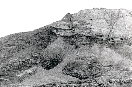
Fig. 29 Brown hyaloclastites (dark) of the Nerutusoq Member interdigitated with grey hyaloclastites (light) of the Nunavik Member. Both units with east-dipping layering. The boundary between brown and grey units is traced with a thin black pen for clarity. North-eastern corner of the valley with the lake Taseraarsuit, bordering to the Siuteqqut Kuuat valley. Height of exposure about 200 m.
In the southern part of Svartenhuk Halvø a few subaerial lava flows of the Nerutusoq Member were deposited on elevated dry land formed by the Kakilisaat Member basalts. The reduced thickness of the member in this area may also be caused by its distal position relative to the main source area in the north.
Eruption sites. As described above, the hyaloclastites and pillow lavas dip away from a common centre located in the southern Nerutusoq valley. This was probably a major eruption centre for the member. Overall, the major volume of the Nerutusoq Member forms a NW–SE-elongated ‘table mountain’ of hyaloclastite capped by cogenetic lava flows, centred on a major eruption area in the Nerutusoq valley area (Fig. 26). This mountain acted as a barrier for the extension of the lower part of the Nunavik Member. The barrier presumably terminated in the area north-west of Firefjeld and was not important in the south. The situation to the west and north-west is unknown.
In the northern Nerutusoq valley and along the west side of the valley of Siuteqqut Kuuat, the brown hyaloclastites show mainly westerly-dipping foreset-bedding and have no capping subaerial lava flows of the member. They were probably fed from a number of NNW–SSE- to NE–SW-trending, aphyric basalt dykes, which cut the hyaloclastites. Several thin, N–S-trending possible feeder dykes are also present in the Taseraarsuit valley. An early, widespread eruptive phase through the dykes therefore appears to have taken place before the volcanism was concentrated in the table-mountain area.
Chemistry and chemostratigraphy. The Nerutusoq Member consists of basalts and magnesian basalts with 8–12 wt% MgO, normal SiO2 contents of 48–49 wt%, relatively high contents of CaO (12–13.6 wt%), and high P2O5 (0.20–0.32 wt%). The P2O5/TiO2 ratios are high, 0.116–0.17. Besides P2O5, the member is relatively enriched in a number of trace elements such as Ba, Th, U, Nb, Zr, Sr and the light rare-earth elements. Representative analyses are given in the Geochemistry chapter.
Boundaries. The Nerutusoq Member rests on lava flows and hyaloclastites of the Kakilisaat Member and in the valley of Simiuttap Kuua possibly on sediments of Paleocene or Cretaceous age. As described above, distinction in the field between the Kakilisaat and Nerutusoq Members is difficult except at close range; they are therefore shown as one unit on the published geological maps. Well-defined boundaries to lava flows of the Kakilisaat Member are exposed at Kakilisaat (profile 4) and Saviit South (profile 13) in south-eastern Svartenhuk Halvø (Fig. 10); there is no indication of a break in the volcanic activity at the boundary.
In the type profile (48b) the lower boundary, which was not visited in the field, is belived to be present along the south-west side of the Simiuttap Kuua valley, with contact towards either Cretaceous sediments or the top of the Kakilisaat Member, if this is present here. Two sedimentary beds between 300 m and 400 m a.s.l. on the north-west side of Simiutaq may be close to the lower boundary. In other places the boundary is not exposed or has not been identified. A 0.5 m thick bed of black mudstone within the brown hyaloclastite south-east of Peak 1309 m may form the lower boundary towards the Kakilisaat Member here.
The upper boundary is best exposed in the valley sides of Nerutusoq in the type profile (48b) and in profile 10. The boundary is distinct because of the colour contrast between the brown lavas of the Nerutusoq Member and the overlying grey picrites of the Nunavik Member. In both profiles there is no indication of any break in the volcanism at the upper boundary; rather, the Nerutusoq Member appears to be partly contemporaneous with the Nunavik Member. A break in the volcanism may be indicated by a shale layer with plant remains at the boundary between a brown and a grey hyaloclastite 3.8 km east-south-east of Peak 1309 m (71°43′53″N, 54°14′35″W, c. 337 m a.s.l.). However, the brown hyaloclastite could also belong to the Kakilisaat Member. The upper boundary reaches a maximum altitude of 860 m at Kakilisaat, 750 m in southern Nerutusoq and 600–650 m in the valley of Taseraarsuit.
Geological age. Paleocene (Danian to Selandian). The Nerutusoq Member is reversely magnetised and was erupted during magnetic polarity chron C26r (Riisager et al. 2003). Its age is thus constrained to the interval 62.2–61 Ma, based on the lower age boundary of C26r and the upper age boundary of the Vaigat Formation. No reliable radiometric age has been obtained for the member.
Correlation. None known.
Nunavik Member
New member
History. On the geological map 71 V.1 Syd Igdlorssuit (Larsen 1983) the Nunavik Member is shown as part of the unit βp (hyaloclastites) and as the unit βo (lava flows). On the geological map 71 V.1 Nord Svartenhuk (Larsen & Grocott 1991) the member is shown as the units βp2 (hyaloclastites) and βo (lava flows); hyaloclastites of the member may also be included in the unit βp (undifferentiated hyaloclastites).
Name. After Nunavik, the former Greenlandic name for Svartenhuk Halvø (now Sigguup Nunaa).
Distribution. The Nunavik Member is exposed over large areas in the eastern half of Svartenhuk Halvø. The member dominates the south coast as far west as Tartuusaq. The westernmost exposure is a small outlier on south-western Svartenhuk Halvø at Narsinganersua/Kap Cranstown. To the north, the member reaches the southern part of the Innerit peninsula where the dips of the hyaloclastite bedding indicate mostly northerly flow directions. Its extension below exposure level north of 72°00′N may be up to 10 km, based on a northward reduction in thickness (see the section on thickness). A significant extension of the member occurs east of the Cretaceous boundary fault system from Kuugaartorfik in the north-west to Qinngusaaq and Uparuaqqusuitsut in the south-east. Due north of Itsaku, the easternmost extension of the member consists of erosional remnants in two small outliers at peaks 1211 and 1270 m (Figs 6, 7), up to 17 km east of the boundary fault. These rocks are situated at some of the highest altitudes for the member due to the postvolcanic uplift discussed by Pulvertaft & Larsen (2002). Altitudes reach c. 1300 m in a small erosional remnant 2.5 km north-east of Qinngusaaq where the upper boundary of the member is preserved (Larsen & Grocott 1991).
Due to the general westerly dip of the volcanic succession, the lower part of the member is well exposed in the eastern part of the basin including the south coast of Svartenhuk Halvø (Fig. 30). The upper part of the member is exposed towards west and south-west, on the Precambrian basement to the east, and on the Innerit peninsula (Fig. 31) to the north. The entire member is exposed in the nearly flat-lying areas of the central and north-eastern parts of the basin.
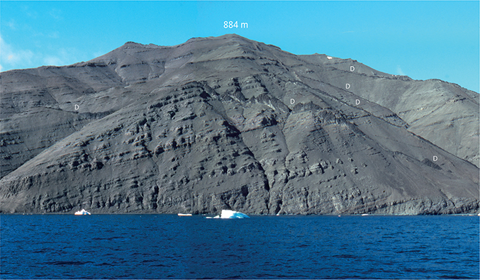
Fig. 30 Picrites typical of the Nunavik Member forming a thick succession of grey, crumbling, compound pahoehoe lava flows dipping 15–20°WSW. Several dark dykes (D) cut the succession. South coast of Svartenhuk Halvø between Saviit and Ulissat; the mountain is Saviit Qaqqaat (884 m). See also Fig. 17.
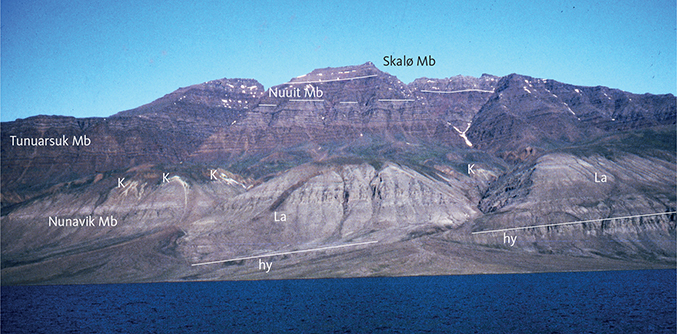
Fig. 31 The northernmost exposures of the Vaigat Formation on the Innerit peninsula. The formation here comprises 300–350 m of hyaloclastites (hy) and subaerial picrite lava flows (La) of the Nunavik Member. These are overlain by the Svartenhuk Formation, which comprises poorly exposed, whitish quartzofeldspathic sediments of the Kuugaartorfik Member (K) overlain by lava flows of the Tunuarsuk, Nuuit and Skalø Members. South-eastern Innerit peninsula beneath the Paannivik mountain; compare Fig. 46. The highest peak on the skyline is at 1288 m.
Type section. Due to faulting, especially in the southern part of the peninsula, it has not been possible to establish a type section that includes the maximum thickness and entire stratigraphy of the Nunavik Member. Peak 1078 m (profile 9) is designated as type section because it is unfaulted, well-sampled and analysed. The profile runs along the south-east side of Peak 1078 m, from 470 m to 1078 m a.s.l. (Figs 9, 11; coordinates in Appendix 1). The lower 600 m of the member are exposed here, but the top is missing; the base is not exposed but is seen 1–2 km south-west of the profile.
Reference sections. Both base and top of the Nunavik Member are exposed in the central and northern areas where the thickness is reduced. A profile on the south side of Peak 1309 m (profile 7; coordinates in Appendix 1) is a reference section; it includes the thickest undisturbed succession in the area, and dips are only 1–2°NNW. The profile was not sampled for geochemical analysis and is not shown in Figs 10–11. The upper boundary is well exposed. The position of the lower boundary cannot be determined on the basis of the present knowledge because grey and brown hyaloclastites of unknown composition are intercalated here. The entire profile is c. 1100 m in thickness. It begins at c. 170 m altitude in a river north-west of Firefjeld, where Cretaceous sediments are overlain by olivine-phyric pillow lavas succeeded up-river by intercalated grey and brown hyaloclastites. At 230 m the profile turns north and follows a side stream uphill; from 450 m grey picritic hyaloclastites belong to the Nunavik Member. At c. 570 m the grey hyaloclastites are overlain by subaerial lava flows of the Nunavik Member. From here the profile climbs the hillside to the top at 1309 m (Figs 9, 32; see also Fig. 40). At the top about 10 m of the lowest flow of plagioclase-phyric basalt of the overlying Tunuarsuk Member is preserved. A palaeomagnetic sample profile by Riisager et al. (2003, 2004) was collected from the subaerial part of this profile.
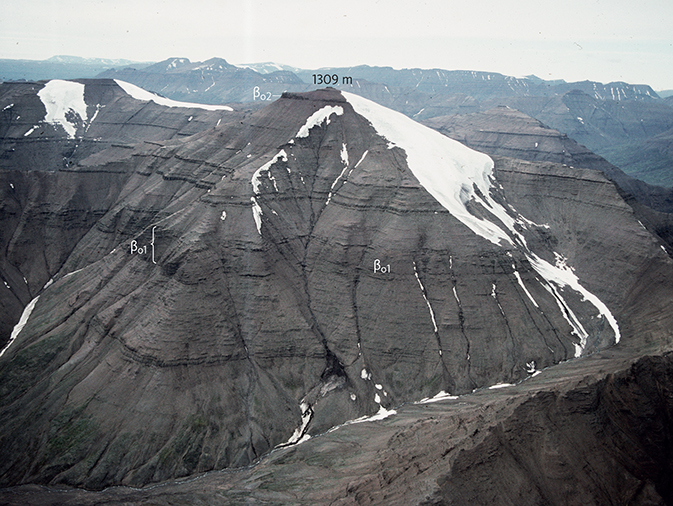
Fig. 32 The Nunavik Member close to reference profile 7. The succession of thin, grey, subaerial picrite lava flows is c. 690 m thick; the underlying hyaloclastites are exposed in the river gully in the lower part of the photo. The mapped marker horizon of dark flows, βo1, is indicated. The βo2 flow near the top is a widespread basalt marker flow in the Nunavik Member. The topmost small remnant of a lava flow is the lowest plagioclase-phyric basalt of the Tunuarsuk Member. Peak 1309 m, central-eastern Svartenhuk Halvø, viewed from the south. The position of profile 7 cannot be shown here but is indicated in Fig. 40. The mountain slope seen here is the site of an important palaeomagnetic profile located on a similar photo in Riisager et al. (2003, fig. 4). Photo: Asger Ken Pedersen.
The second reference section is Peak 1120 m (profile 24) on the north-western valley side of the headwaters of Saviit Kuussuat, where the upper 700 m of the member are exposed from 270 m to 970 m altitude (Figs 9, 10; coordinates in Appendix 1). The profiles cannot be correlated by field observations or chemical data, a fact which applies to most profiles in this member in areas where faulting is common. Profile 24 is located west of a flexure zone south of Usuit Kuussuat, which has caused a downthrow of at least 90 m of the lavas to the west (Fig. 33; Larsen & Pulvertaft 2000, p. 27 and fig. 11).
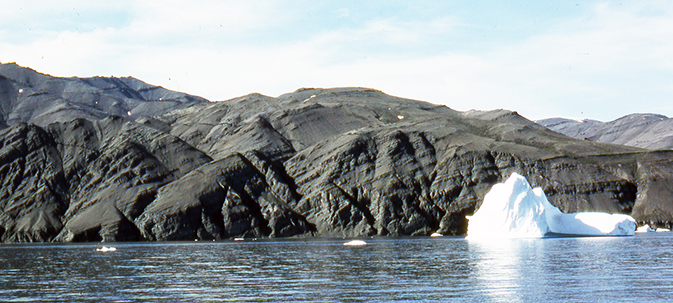
Fig. 33 Well-exposed lavas of the Nunavik Member in the large flexure zone that runs SSE from Usuit Kuussuat to the south coast west of Ulissat (Fig. 6). Over the about 700 m from right to left in the photo, the dip of the lava flows changes from 5°WSW to 30°WSW through two sets of closely spaced faults oriented WNW–SSE and NNW–SSE (Larsen & Pulvertaft 2000). Displacements on the faults are difficult to see due to the monotonous lithology of the Nunavik Member; an interpretation is shown in Fig. 17 (Saviit flexure zone). South coast of Svartenhuk Halvø just west of Ulissat.
Thickness. From south to north in the basinal area, thicknesses decrease from in excess of 930 m (including 120 m hyaloclastite) in the Issiallaap Qaqqaa area, to 855 m (300 m hyaloclastite) in the profile of Peak 1309 m, to 800 m (250 m hyaloclastite) at Peak 1250 m south of Simiutaq, and 600–900 m (c. 300 m hyaloclastite) on the south-west side of the Simiuttap Kuua valley. On Innerit the exposed thickness is 380 m, including 180 m of hyaloclastite, and a total thickness of around 500 m is possible if the hyaloclastites continue below sea level to attain a thickness of 300 m, similar to that on Svartenhuk Halvø. The reduced thickness of the subaerial lava succession on Innerit corresponds to a lava shield with a northerly slope of 1° (as argued in the description of marker horizon βo1). By extrapolating the decreasing thickness of the subaerial lava pile to the north, it is inferred that the lava flows of the member may have travelled up to 10 km farther north before the uppermost flow had reached sea level and the progradation stopped.
In the central area around Nerutusoq, the thickness is only 325 m because an eruption centre of the underlying Nerutusoq Member formed a local high (Fig. 26) around which the lowest Nunavik Member lavas flowed.
On southern Svartenhuk Halvø, the western outlier at Kap Cranstown comprises 280 m of the upper part of the member (Fig. 34). Along the south coast from Tartuusaq to Maniiseqqut, uplift along numerous NW–SE- and WNW–ESE-trending faults has exposed the Nunavik Member for 32 km (Fig. 30). It is difficult to estimate the thickness of the member in the southern area due to the faulting and lack of marker horizons. The maximum thickness in a single fault block is around 2000 m without the presence of either base or top (Fig. 16 east of Tartuusaq). Thus the thickness of the Nunavik Member in the southern area is certainly more than 2000 m. Calculation of the actual thickness depends on estimates of the throw on many faults and subsidence in flexure zones. Possible shingling of the lava pile, i.e. lateral shift of volcanic deposits with time, would be another complicating factor because it makes the stratigraphic thickness different from actual thicknesses at any location. Further discussion is found in Larsen & Pulvertaft (2000, p. 34–35).
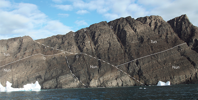
Fig. 34 Subaerial lava flows of the upper part of the Nunavik Member of the Vaigat Formation (Nun) overlain by subaerial lava flows of Tunuarsuk Member of the Svartenhuk Formation (Tun) at Narsinganersua/Kap Cranstown, south-western Svartenhuk Halvø. The sedimentary Kuugaartorfik Member is not present here. The succession is repeatedly faulted; the apparent low-angle fault is a WNW–ESE-trending fault that cuts obliquely through the exposure. Note several crosscutting dykes (D) perpendicular to the orientation of the lava flows. The colour differences seen are partly caused by superficial alteration. The exposed section of the Nunavik Member is 280 m thick. Compare Fig. 14. Photo: Asger Ken Pedersen.
On the Precambrian basement, thicknesses decrease eastwards from about 400–500 m in the west on Qinngusaaq and Kuugaartorfik, and the member wedges out at an altitude of around 1100 m in the north-east. In the easternmost outliers at Peaks 1211 m and 1270 m, 250–270 m of picrites comprising hyaloclastites, pillow lavas and subaerial flows were erupted through local feeder dykes (Fig. 26).
Lithology. The Nunavik Member is characterised by olivine-rich tholeiitic picrites and olivine-phyric to olivine-microphyric magnesian basalts and subordinate basalts. The member consists of hyaloclastites and coarser pillow breccias overlain by subaerial lava flows of compound pahoehoe type together with a few prominent, thick sheet flows. Tuffs and soils are relatively rare, forming red beds 5–20 cm in thickness between the lava flows. Other sediments are scarce and include volcanogenic conglomerates (Fig. 35) and sandstones, and more fine-grained silty beds. The member has light greenish grey or purplish grey weathering colours. The light grey colour is due to zeolite-filled vesicles. A few erosion-resistant picritic lava flows may have brown weathering colours and may therefore resemble brown basaltic, MgO-poor lava flows from a distance (Fig. 22).
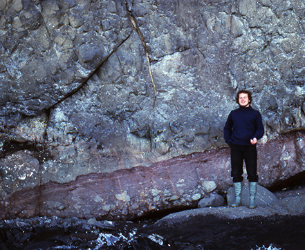
Fig. 35 Conglomerate with large clasts of volcanic rocks in a matrix of reddish volcanogenic sandstone and with a red-oxidised soil layer on top. The overlying rock is a massive picrite lava flow. The sediment is interpreted as a mass-flow deposit formed in connection with early tectonic movements along faults in the Saviit flexure zone. Field assistant for scale. South coast of Svartenhuk Halvø beneath Saviit Qaqqaat, sample number 181052 in Fig. 17.
Compound pahoehoe lava flows. The lava pile is built up of compound pahoehoe flows in packages that may reach thicknesses exceeding 100 m without any indication of an eruptive pause. The average package thickness in different profiles ranges from 26 m to 55 m. Individual flow units range from flow lobes 20 cm thick (Fig. 36) to sheet flows 25 m thick, but most flow units are below 5 m and generally 1–3 m thick. Thinning of the flow units is apparent in the distal areas on the southern Innerit peninsula where the flow units are about 1–2 m thick. The pahoehoe flow units commonly have basal zones that are c. 10 cm thick with pipe amygdales, which are strongly inclined in the flow direction in the upper part of the zone. The orientation of these pipe amygdales has been used to determine the flow direction of the lavas (Larsen 1981b). Above this basal zone about half of each flow is massive and the upper half is crumbling and highly amygdaloidal, with amygdale banding parallel to the lava top. This banding was formed by upwards concentration of gas released from the still-flowing liquid lava under the solidifying crust. The flow units may be continuous through fully exposed fields of view of 50–100 m or more, reflecting their highly fluid nature as well as a planar and nearly horizontal topography during eruption. In other places the flow units are lensoid and of short lateral extent because they represent cross-sections through pahoehoe flow lobes (Fig. 36).
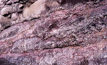
Fig. 36 Overlapping flow lobes in a compound pahoehoe lava flow. Note the numerous zeolite-filled vesicles and thorough red-oxidation, strongest at the tops of individual flow lobes. Height of picture c. 1 m. Cliff at Kap Cranstown, south-western Svartenhuk Halvø. Photo: Asger Ken Pedersen.
Massive sheet flows. These sheet flows are mostly 4–16 m thick, with a few reaching 25 m in thickness. They are fine-grained and form erosion-resistant horizons. Columnar jointing may be present. A scoriaceous top zone forms approximately one-fifth of the thickness of a single lava flow, whereas a scoriaceous base is missing or strongly reduced. The two types of flows are illustrated in Fig. 37.
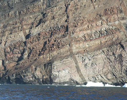
Fig. 37 Lava succession comprising alternating groups of thick, massive sheet flows and compound pahoehoe flows built up of many individual, thin flow lobes. The lower pahoehoe flow group is topped by a dark grey sediment horizon. The overlying sheet flows have red soil horizons between them. Dykes cut the flows at approximately right angles. Height of section c. 60 m. Upper part of Nunavik Member at Kap Cranstown, south-western Svartenhuk Halvø. Photo: Asger Ken Pedersen.
Subaqueous volcanic rocks. The subaqueous products comprise hyaloclastites, coarser pillow breccias and pillow lavas (Fig. 38). The hyaloclastites are commonly characterised by gigantic foreset-bedding and form deposits with a thickness of up to several hundred metres, similar to hyaloclastites of the Vaigat Formation on Disko and Nuussuaq (Pedersen et al. 2017, 2018). The foreset-bedding dips from 33° to nearly horizontal. Steeper dips have also been recorded. The bedding is brought about by trains of material with greater concentration of coarse clasts of pillow fragments interspersed with layers of finer material with fewer of such fragments. The distal bottomsets have low dips and are composed of relatively fine material, and sediment intercalations may be found. In several places (e.g. along Simiuttap Kuua) the compound pahoehoe lava flows can be followed into steeply north-dipping pillow beds and pillow breccias with foresets with a vertical height of more than 200 m. No contemporaneous coastal erosion of the hyaloclastite layers has been observed, which suggests a very short period of eruption.
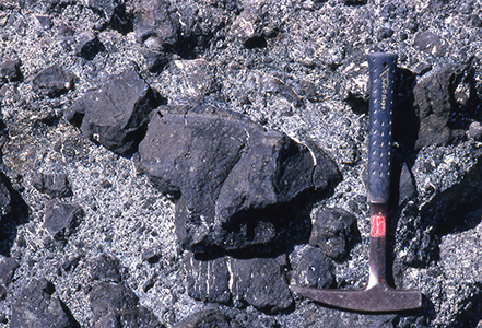
Fig. 38 Typical coarse hyaloclastite with unsorted pillow fragments in a matrix of glass grains and rich in zeolites. The rock is an olivine-rich picrite. Note the 1 cm glass rind on the largest pillow fragment. Length of hammer 32 cm. Upper Nunavik Member, southern Innerit. Photo: Asger Ken Pedersen.
Tuffaceous and other fine-grained volcaniclastic deposits. Tuffaceous and soil beds are rare and are generally too thin and poorly exposed to be mapped. Most tuff and soil beds are 5–20 cm in thickness and in a subaerial environment they have generally been baked to a brick-red colour by the overlying lava flow. The beds are characterised by an even thickness over the whole surface of the underlying lava flow. Together with the thicker sediments mentioned below, these beds represent the only certain pauses in deposition of the lava beds. They are most frequent in the upper part of the member in the central area, where one horizon every 50 m in the upper part of the member has been recorded. The higher frequency of sedimentary beds between flows suggests longer time intervals between eruptions and decreasing magma production rates towards the top of the member.
A few thicker sedimentary beds occur. Some of these are brown or black; the most significant tuff bed is 8–15 m thick. In the south-eastern area a 14 m thick sedimentary bed is situated 540 m above the base of the member (profile 5). The bed consists of ellipsoidal basalt pebbles at the base, followed by volcanogenic sandstones and shales with plant fossils, e.g. Ginkgoites. On the south coast south of Saviit Qaqqaat, two 4–7 m thick sedimentary beds occur west of the Saviit–Qooroq fault zone (Figs 17, 35). They consist of volcanogenic sandstone and conglomerate with basalt boulders, possibly slide deposits. The fact that coarse clastic beds of local aspect are present in the area west of the Saviit–Qooroq fault zone may relate them to early uplift of the block east of the fault. On the south coast at Tartuusaq, a 2–3 m thick tuff layer is present in the upper part of the member where it appears to reveal a stratigraphic repetition (Fig. 16). In the same section a 15 m thick bed of shale and tuff is situated at the upper boundary of the Vaigat Formation.
A crimson-red bed c. 8 m thick of welded basaltic tuff very near the upper boundary of the member was mapped by Larsen & Grocott (1991) within an area of c. 10 × 3 km in the upper reaches of the valley that leads into Tasiusap Imaa (Figs 26, 39).
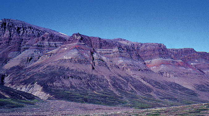
Fig. 39 The upper part of the Nunavik Member (Nun) containing a crimson-red bed c. 8 m thick of welded basaltic tuff (white arrows) within grey pahoehoe flows near the boundary to the Tunuarsuk Member (Tun). The boundary is traced with white lines. Akuleqqut, southern Svartenhuk Halvø.
Marker horizons. The hyaloclastites in the basal or lower part of the member form distinct beds, which can be used as marker horizons. Tuffs and sediments are well exposed along the south coast where they are useful for short-distance correlation across faults.
Some lava flows can be used as markers:
- In the southern, south-eastern and central eastern areas, a distinct, dark green, massive picrite lava flow or sill 15–30 m thick containing equant olivine phenocrysts up to 1 cm across occurs immediately above the Nerutusoq Member.
- On the southern side of Peak 1309 m in the central area, and in part of the south-eastern area, a characteristic 70 m thick, dark group of flows with many thin pahoehoe flow lobes occurs 300 m above the hyaloclastite (Fig. 32). This horizon is easy to identify from a distance and on the oblique aerial photographs and is shown as βo1 on the geological map 1:100 000 Svartenhuk. It can be followed over a distance of 26 km from a location 400 m above the hyaloclastite south of Peak 1078 m and northwards to the west side of the valley of Siuteqqut Kuuat, where it goes into hyaloclastite facies (Fig. 27). The dark flows also have a distinctly enriched chemical composition (see the Geochemistry chapter), and their palaeomagnetic properties are different from those of the underlying grey flows, suggesting a considerable time lapse between the two parts (Riisager et al. 2003, 2004). The topographic slope of the flows was 0.9°N.
- Overlying the dark βo1 flow group is a 80 m thick, grey, zeolite-rich group of picrite lava flows comprising thick flow units with segregation veins. It has an areal distribution similar to the βo1 flow group.
- Some picritic sheet flows with olivine-rich nodules occur about 200 m below the top of the member and some tens of metres below a significant tuff horizon in the west at Kap Cranstown and in the central area on the south side of Usuit Kuussuat.
- The uppermost part of the member is dominated by less olivine-rich basalts with a persistent, nearly aphyric, massive basalt flow (βo2) present in many profiles in the central area (Fig. 10, profile 24) and at Tartuusaq (Fig. 16).
Eruption sites. In general, picritic dykes are spatially restricted to the Nunavik Member. They are therefore regarded as feeder dykes for the member, and this relationship has been observed in a few places. North of Kangiusap Imaa, a picrite dyke cutting the hyaloclastites shows a gradual change into pillow facies at an altitude above 900 m. On the south side of Peak 1309 m, a dyke changes laterally into a picrite lava flow of the βo1 marker horizon (Fig. 40). Also in this area (for example at 71°44′N, 54°16–17′W, Larsen & Grocott 1991) dense swarms of thin, irregular, WSW–ENE-trending picrite dykes with 1–2 mm sized olivine phenocrysts appear to be feeder dykes for the picritic hyaloclastite as most of them terminate below the lavas. Such swarms of feeder dykes terminating in hyaloclastite heaps are similar to eruption sites mapped and described from Nuussuaq (Pedersen et al. 2007a,b, 2017).
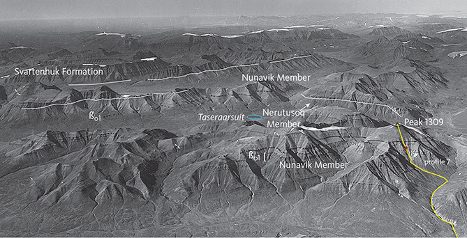
Fig. 40 Nunavik Member in central Svartenhuk Halvø around the Taseraarsuit lake (blue oval), viewed towards north-west. The Nunavik Member is underlain by lava flows and hyaloclastites of the Nerutusoq Member. The marker horizon βo1 is indicated both in the foreground and in the middle ground. Other local markers are traced in black on the original photograph. The white lines indicate the boundary between the Nunavik Member and the Svartenhuk Formation. Profile 7, Peak 1309 m, is indicated with a yellow line in the right foreground. The small red dot on the profile line indicates a feeder dyke for the lowest flows in the βo1 marker horizon. Geodetic Institute oblique aerial photograph 526FN/3759.
The crimson-red bed of welded basaltic tuff mentioned above, which occurs close to the top of the member in a c. 10 × 3 km area in south-central Svartenhuk Halvø (Fig. 39), must have been produced from a local eruption site within that area (approximately 71°34′N, 54°42′W, Fig. 26), probably a fissure that was waterlogged at the time of eruption.
Volcanic evolution of the Nunavik Member. At the start of the deposition of the Nunavik Member a water-filled basin was situated along the Cretaceous boundary fault system. Its extent towards the north and west is unknown because the relevant rocks are below exposure level, and it is also not clear whether the basin was still marine. On Nuussuaq 100 km to the south, a similar marine basin had at this time just been sealed off from the sea and changed into a large lake into which hyaloclastites and lava flows of the Ordlingassoq Member, the correlative to the Nunavik Member, were deposited (Pedersen et al. 1996, 2017). It is possible that the basin north of this seal was still connected to the sea; this remains to be investigated.
When the eruption of the Nunavik Member began, a topographic high of earlier volcanic products existed in the south and south-west, from where subaerial lavas flowed towards the east, north-east and north and into the water-filled basin along the Cretaceous boundary fault system. The stratigraphy, inclination of the foreset beds of the hyaloclastites and flow directions of the lava flows (Fig. 26; Larsen 1981b) all support this picture. The advancing lava flows filled the basin with prograding hyaloclastite deposits several hundred metres thick, and only after this filling was achieved could the lava flows advance further. In this way a large part of the subaerial flows of the southern area were converted into equivalent hyaloclastite breccias towards the north and east. Thus, the thickness of the subaerial lava pile decreases to the north and east. At a later stage, the Precambrian basement was covered by both hyaloclastites and subaerial lava flows.
Hyaloclastites. The thickness of the hyaloclastites increases from 50 m to 120 m from south to north along the east coast of Svartenhuk Halvø. Farther north, the hyaloclastites are more than 400 m thick on Firefjeld and 300–400 m in the central and north-eastern basin areas at Siuteqqut Kuuat and the south-west side of the Simiuttap Kuua valley. West of Firefjeld, however, only 50 m of picritic hyaloclastites are found, indicating that a topographic high existed here. To the north-west, the local large depocentre of the Nerutusoq Member (Fig. 26) blocked for deposition of the picritic hyaloclastites of the lower Nunavik Member. Hyaloclastites overlie the Precambrian basement at two stratigraphic levels, which both increase in thickness northwards, where they have filled a depression in the highland south-east of Siuteqqut. The foreset-bedding of both hyaloclastite horizons indicates northerly and north-easterly transport directions. In conclusion, while the Precambrian basement as a whole acted as a barrier for the early volcanism of the Vaigat Formation it was either partly submerged below sea level, covered by a lake or cut by river channels when the first picrites reached the area or were emplaced locally. After the first infilling and subsequent formation of subaerial lava flows, submergence recurred from the east and caused the formation of the second hyaloclastite horizon. Thus, a general subsidence of the eastern and north-eastern part of the Precambrian basement took place during this period.
The lava pile. The lava pile appears to have formed a lava shield with a low-angle slope of 1° to the north. A study of the flow thicknesses shows that the thickest pahoehoe compound flows are found in the lower part of the member in the south-eastern and central-eastern areas. The thinner compound flows in the upper part of the member presumably reflect decreasing erupted volumes and possibly also thinning of the lava flows in the distal areas. On Innerit, the lava flows are thin, c. 1–2 m, and very fine-grained to aphanitic and thus appear to have been chilled quickly. These features are presumably a consequence of the distal position of the flows far from the extrusion sites in the south.
Thicker sheet flows are much more abundant to the west. In the Tasiusaq area they form 37% of the lava flows, and a similar value is found on Qinnivik. Elsewhere, they represent less than 5%, which could indicate different source areas.
Chemistry and chemostratigraphy. The Nunavik Member is strongly dominated by picrites; basalts are subordinate. The total range in MgO is 7.5–29.8 wt% with an average content of 17.5 wt% MgO. Other major elements such as TiO2 and FeO* are correspondingly low relative to the MgO-poorer Svartenhuk Formation basalts (see the Geochemistry chapter). The Nunavik Member is generally not crustally contaminated, but a few exceptions occur in the lower part of the succession. Representative analyses are given in the Geochemistry chapter.
Some flows have slightly higher TiO2 contents than the main part (for similar contents of MgO). These occur interspersed within the succession; it has not been possible to establish a detailed chemical stratigraphy of the member.
Lava flows, which are geochemically enriched in incompatible trace elements, occur sporadically as single flows or groups of flows. The dark picrite flows in the βo1 marker horizon are distinctly enriched in these elements (see data for sample 251527 in the Geochemistry chapter).
Boundaries. The lower boundary of the Nunavik Member is placed at the base of greyish picrite lava flows or hyaloclastites overlying the brown basaltic lava flows or hyaloclastites of the Nerutusoq or Kakilisaat Members. In reference profile 7 (Peak 1309 m), grey hyaloclastites and pillow lavas rest directly on Cretaceous sediments, but the relation of these rocks to the Nunavik Member is uncertain.
The upper boundary is defined by the occurrence of the first evolved basalts of the overlying Tunuarsuk Member of the Svartenhuk Formation, which have a distinctive brown weathering colour. In the northern area, the boundary is marked by the first deposits of white to yellow sands of the Kuugaartorfik Member. In this area, there is a small angular unconformity at the boundary as described in the section on the lower boundary of the Svartenhuk Fomation.
Geological age. Paleocene (Danian to Selandian).The age of the Nunavik Member is constrained to the interval 62.2–60 Ma based on its eruption later than magnetic polarity chron C27n (Riisager et al. 2003) and the age of the overlying Svartenhuk Formation. The 40Ar/39Ar age of 61.08 ± 0.56 Ma obtained by Chauvet et al. (2019) for a silicic basalt flow is within this age interval, regardless of whether the flow is from the Nunavik or the Kakilisaat Member.
Correlation. The Nunavik Member is correlated with the Ordlingassoq Member of the Vaigat Formation on Ubekendt Ejland, Nuussuaq and Disko, based on its stratigraphic position within the lava pile and similarities in the chemical compositions illustrated in the Geochemistry chapter (see also Figs 83, 84). Both these members are relatively heterogeneous and not quite as depleted in incompatible trace elements as the older Anaanaa and Naujánguit Members of the Vaigat Formation on Disko and Nuussuaq (Larsen & Pedersen 2009, 2017).
Svartenhuk Formation
New formation
History. On the geological map 71 V.1 Syd Igdlorssuit (Larsen 1983), the Svartenhuk Formation is shown as the units βf3 to βf6. On the geological map 71 V.1 Nord Svartenhuk (Larsen & Grocott 1991), the Svartenhuk Formation comprises the sedimentary unit T (for Tertiary) and the volcanic units β1 to β3, i.e. the entire basalt succession overlying the Vaigat Formation. The name Svartenhuk Formation was used in the same sense by Larsen & Pulvertaft (2000), but the formation was not formally defined. Larsen et al. (2016) found that the basalt succession consisted of two parts of, respectively, Paleocene and Eocene age and restricted the Svartenhuk Formation to comprise only the Paleocene part (Fig. 3). Here the Svartenhuk Formation is defined to comprise the Paleocene part of the succession, whereas the Eocene part is defined as the Naqerloq Formation in a later chapter.
Name. After Svartenhuk (Sigguk), the most westerly point on the peninsula of Svartenhuk Halvø.
Synonymy. The informal ‘middle formation’ and a part of the ‘upper formation’ of Larsen (1981a) and Holm et al. (1993).
Subdivisions. The Svartenhuk Formation is divided into four members based on lithological and chemical characters (TiO2 contents). These are from base to top:
Kuugaartorfik Member: Quartzofeldspathic sands, mudstones, coal seams, volcanogenic sediments and tuffs. The sediments are interspersed with hyaloclastites and subaqueous and probably invasive lava flows of the Tunuarsuk Member.
Tunuarsuk Member: Brown basalts, grey olivine-phyric basalts and subordinate dark greenish grey picrites. The lowest part of the member in the northern area comprises hyaloclastites and subaqueous and invasive lava flows, whereas the main part of the member comprises subaerial lava flows.
Nuuit Member: Brown aphyric and plagioclase-phyric basalts, mainly subaerial lava flows.
Skalø Member: Mostly light grey to yellowish, plagioclase-phyric basalts, subaerial lava flows.
Distribution. The Svartenhuk Formation is found in central, northern and western Svartenhuk Halvø but has been eroded away in the eastern part of the basin area. The formation is widely distributed north of Svartenhuk Halvø where it occurs as far north as 72°43′N (Figs 5, 6). The formation extends from the coastal islands in the west at 56°W and eastwards onto the Precambrian basement areas as far east as at least 51°35′W at 72°N (Fig. 5); the extent of the volcanic rocks farther east and north-east beneath the Greenland ice sheet is unknown. To the west and north-west, the formation is considered to continue on the shelf, which is supported by a seismic section reaching as close as 10 km from the west coast of Svartenhuk Halvø (Gregersen et al. 2013, fig. 5), and by the composition of basalt samples dredged on the Upernavik Escarpment (Fig. 1; Polteau & Planke 2008; analytical data are given in the Geochemistry chapter). In the sea south of Svartenhuk Halvø, the formation is interpreted as a more than c. 800 m thick package of west-dipping strata seen in seismic section GEUS00-50 (Skaarup & Pulvertaft 2007). Some volcanic units on western Ubekendt Ejland and western Nuussuaq are also included in the Svartenhuk Formation based on their age (see the section on Correlation).
Type area. The south-east coast of the Innerit peninsula. This coastal stretch shows the most complete section through the formation, with all four members present in a well-exposed, flat-lying, unfaulted succession (Fig. 41). Here 100–200 m of sediments and subaqueous volcanic deposits are overlain by c. 1350 m of lava flows sampled in profile 64 Paannivik (Figs 13, 41). The Paannivik profile is the type section for the Tunuarsuk and Nuuit Members, whereas the Skalø Member is incomplete and the Kuugaartorfik Member is partly exposed 4 km east of the profile.
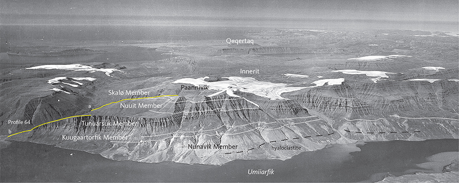
Fig. 41 The most complete exposed section through the Svartenhuk Formation, resting on the Vaigat Formation and with all four members present. Profile 64 a and b are shown with yellow lines; the profile is depicted in Fig. 13. South-eastern Innerit peninsula. The Paannivik mountain reaches 1288 m altitude. Geodetic Institute oblique aerial photograph 526HN/5634.
Thickness. The sum of the greatest thicknesses of the four members of the Svartenhuk Formation in the basinal area is 110 + 850 + 480 + 450 = 1890 m. There is not one single area in which this thickness is attained. The most complete profile (no 64 Paannivik) has a thickness of c. 1350 m for the volcanic succession, but the upper boundary has been removed by erosion. Distal thicknesses in the northern areas are up to 1000 m, for example at Qaqqap Qaa (Figs 9, 13). Farther to the north-east, the preserved thickness is c. 600 m at Pannertuup Qaqqa and 660 m at Salliaruseq, in both places constituted by relatively few, thick, presumably ponded flows. In the eastern and north-eastern areas, an unknown thickness of basalt has been removed by erosion and in the most distal areas only remnants of basalt are left. In the domal area east-south-east of Svartenhuk Halvø (Fig. 5), no volcanic rocks are preserved.
Lithology. The volcanic rocks are brown and grey aphyric and plagioclase + olivine ± clinopyroxene-phyric, mainly subaerial tholeiitic basalts and subordinate olivine-phyric magnesian basalts and picrites. Subaqueous lava flows and hyaloclastites are present in the lower part of the formation in the northern and north-eastern areas. Quartzofeldspathic sediments are present in the north-western and north-eastern areas. Thin horizons of tuffs and sediments are present throughout the formation.
Eruption sites. In contrast to the picrite successions of the Vaigat Formation, for which several eruption sites are known, only very few eruption sites have been identified for the basalts of the Svartenhuk Formation. This is a feature shared with flood basalt successions worldwide, including those on Nuussuaq and Disko (Pedersen et al. 2017, 2018), presumably caused by the effusive character of the fissure eruptions, which fed the lava flows. The oxidised products of more explosive eruptions from central vents are more easily visible, and some sites of this character have been identified.
Basalt dykes cutting the older parts of the volcanic successions, with compositions matching those of the Svartenhuk Formation, can be regarded as feeders for this. Such dykes exist, but the data are too sparse to give a reliable impression of the extent of the lava production areas. However, no dykes are known more than 10 km east of the boundary fault, and the large volcanic areas to the north and east were presumably sourced from eruption sites within the basin area on Svartenhuk Halvø and just outside it close to the boundary fault.
Chemistry and chemostratigraphy. The volcanic rocks of the Svartenhuk Formation consist of evolved tholeiitic basalts with 3.5–10 wt% MgO and, in the lowest member, also magnesian basalts and picrites with 10–18 wt% MgO. The rocks have low contents of incompatible elements such as K2O (0.08–0.5 wt%) and low P2O5/TiO2 ratios (0.07–0.12). A few scattered lavas enriched in incompatible elements occur throughout the succession. Representative analyses are given in the Geochemistry chapter.
The formation shows subtle chemostratigraphic variations up-section, which are recognisable throughout the area and have been an important help in the validation of the field-based stratigraphy. The variations are best seen in plots of TiO2 contents vs. height in sample profiles as shown in Fig. 42.
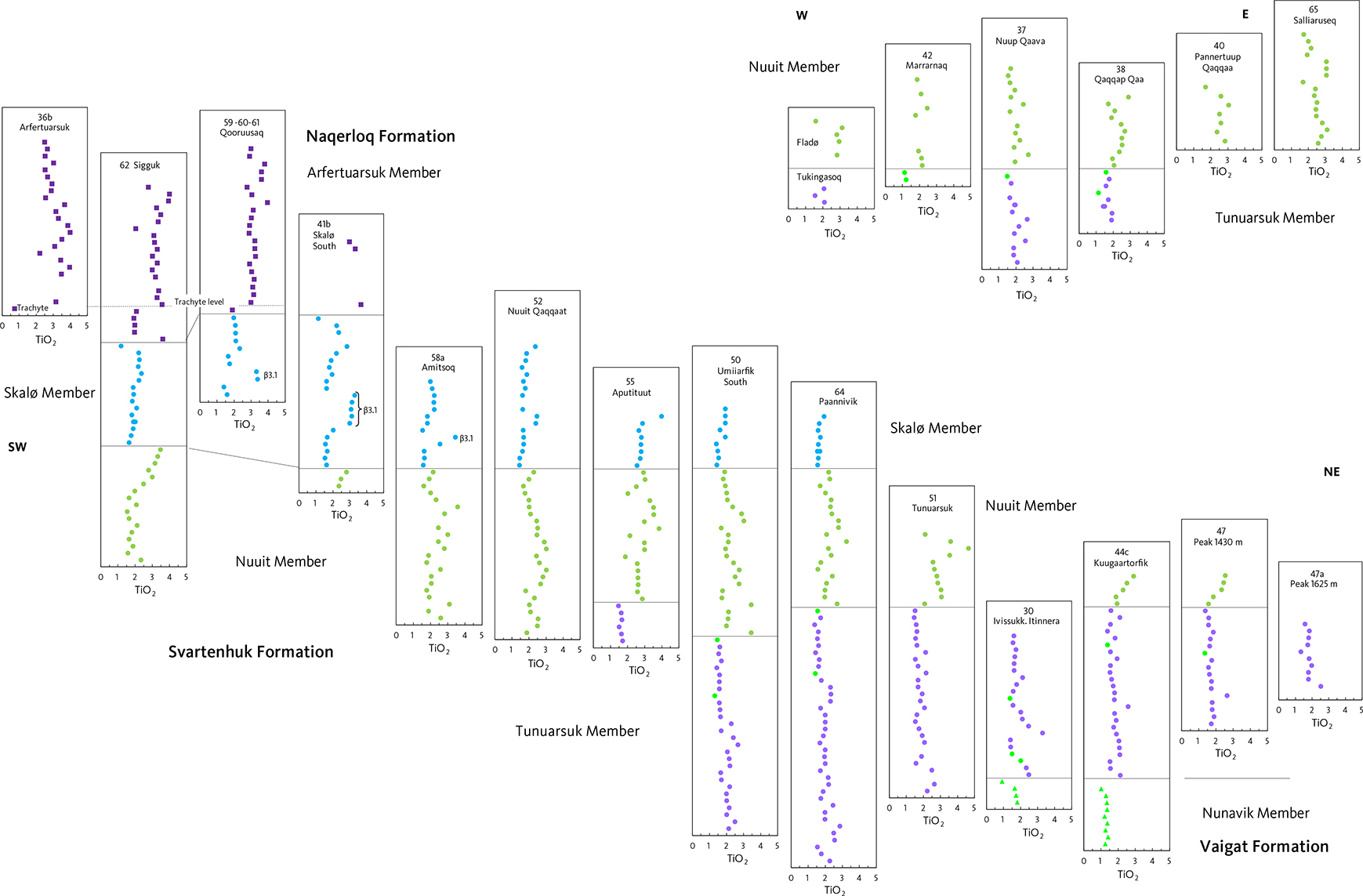
Fig. 42 TiO2(wt%) for profiles through the Svartenhuk and Naqerloq Formations. The profiles in the lower panel are arranged as projected on a SW–NE line through central Svartenhuk Halvø. The profiles north of 72°N in the upper panel are arranged as projected on a W–E line around 72°15′N. The vertical scale is the number, starting from 1, assigned to each of the successive flows in a profile. The profiles are aligned on member boundaries, as feasible. Dot colours and shapes as in the geochemistry diagrams, see legends in Fig. 83. Dark green dots in the Tunuarsuk Member are picrites.
Boundaries. The lower boundary in southern and central Svartenhuk Halvø is placed at the first occurrence of subaerial, brown-weathering, olivine-poor, plagioclase-phyric basalts above the main picrite series of the underlying Vaigat Formation. In northern Svartenhuk Halvø, where subaqueous and fluvial conditions prevailed, the lower boundary is placed at the base of a succession of white quartzofeldspathic sand, volcanogenic sediments and olivine-poor hylaoclastites that overlie the picrites of the Vaigat Formation.
Tectonic movements prior to the emplacement of the Svartenhuk Formation (Larsen & Pulvertaft 2000) gave rise to minor unconformities between the two formations. This is seen at two localities labelled H and I, shown on Fig. 6. Loc. H: Between 71°36′N, 54°33′W and 71°35.5′N, 54°29′W along the southern side of the central part of Usuit Kuussuat, 11–17°S- to SE-dipping picrite flows underlie 5–8°W- to SW-dipping flows of the Svartenhuk Formation. Loc. I: On the west side of the Kuugaartorfik mountain east of the inner Umiiarfik fjord and north-east of the Cretaceous boundary fault system, lava flows of the Nunavik Member dip 8–10°NE, whereas the Svartenhuk Formation is nearly horizontal with low NW-dips.
An unconformity is seen on south-eastern Innerit between Locs B and E (Fig. 6). Here, lavas of the Nunavik Member appear to dip NW whereas the Svartenhuk Formation has a low dip of 2–4°SW, decreasing up-section. This is interpreted as a depositional unconformity, with the lavas of the Svartenhuk Formation drowning the domed lava shield of the Vaigat Formation.
The upper boundary is defined in the Sigguk profile in western Svartenhuk Halvø (Fig. 11). The boundary here is placed at the base of a series of brown-weathering, geochemially enriched basalts of the Naqerloq Formation (Arfertuarsuk Member) characterised by higher contents of incompatible elements than the basalts of the Svartenhuk Formation. The brown basalts rest on a poorly exposed tuffaceous sediment horizon 5–10 m in thickness, which constitutes the top of the Skalø Member of the Svartenhuk Formation. In south-western Svartenhuk Halvø north of Arfertuarsuk, a similar, but coarser, volcaniclastic sediment horizon is c. 20 m thick. It is overlain by 0–2 flows with chemical compositions corresponding to the Naqerloq Formation, followed by the thick marker flow of the Arfertuarsuk trachyte. In the upper reaches of the Qooruusaq valley at c. 180 m a.s.l. the sediment horizon (inferred, 10–15 m unexposed) is directly overlain by an erosional remnant of the Arfertuarsuk trachyte. The boundary is also present on Skalø; it has not been mapped there and is not shown on the 1:100 000 map of Larsen & Grocott (1991) but was identified by sampling and chemistry. Its inferred position is shown on Fig. 6.
Geological age. Paleocene (Selandian to Thanetian). Radiometric age determinations (40Ar/39Ar) of the Svartenhuk Formation range from 59.78 ± 0.41 Ma (Chauvet et al. 2019), 60.31 ± 1.39 Ma and 59.05 ± 0.61 Ma for the lowermost part (Tunuarsuk Member) to 57.98 ± 0.59 Ma for the upper part (Skalø Member) of the formation (Larsen et al. 2016). 40Ar/39Ar age determinations of the Maligât Formation above the Vaigat Formation in the Disko–Nuussuaq area range from 61.2 ± 0.4 Ma to 60.2 ± 0.5 Ma (Storey et al. 1998). This shows that most of the Svartenhuk Formation is younger than the Maligât Formation and that there is a possible overlap in time for the oldest basalts of the Svartenhuk Formation (Fig. 3).
Correlation. The Qeqertalik and Tuperssuartâta kûa Members on Ubekendt Ejland and the Nûluk and Ifsorisoq Members on Nuussuaq west of the Itilli fault have been placed within the Svartenhuk Formation based on their radiometric ages (Fig. 3; Larsen et al. 2016).
The thick tuffaceous sediment horizon at the top of the Svartenhuk Formation is tentatively correlated with the sediments of the Ifsorisok Member on Nuussuaq (Hald 1976; Larsen et al. 2016). The horizon is thus potentially of regional extent and is interpreted as representing a break in the volcanic activity.
Kuugaartorfik Member
New member
History. The member is shown as intravolcanic sediments (T) on the geological map 71 V.1 Nord Svartenhuk (Larsen & Grocott 1991).
Name. After the mountain Kuugaartorfik in northern Svartenhuk Halvø.
Distribution. The Kuugaartorfik Member is exposed in northern Svartenhuk Halvø and the south-eastern part of the Innerit peninsula, in both areas resting on lava flows of the Vaigat Formation (Larsen & Grocott 1991; Fig. 6). North of 72°N, along the coasts of the Innerit inlet, sediments of the member are exposed at sea level below the lavas of the Svartenhuk Formation. Isolated outcrops of the member rest on basement gneiss on both sides of Sullua, the northern arm of the Umiiarfik fjord (Fig. 6). The southern delimitation is depositional; to the west the member disappears below exposure level and to the north and east its extent is unknown.
Type section. Kuugaartorfik (profile 44c, Fig. 12), located in a well-exposed west-facing gully on the north-west slope of Kuugaartorfik mountain between 380 and 490 m a.s.l. (Fig. 43). Coordinates in Appendix 1.
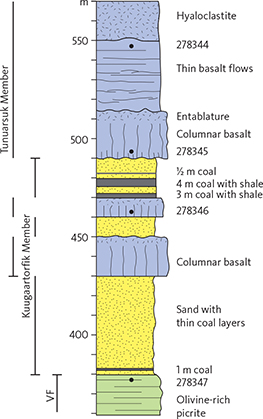
Fig. 43 Type section for the Kuugaartorfik Member in profile 44c, Kuugaartorfik. VF: Vaigat Formation (Nunavik Member). Sediments of the Kuugaartorfik Member and lava flows of the Tunuarsuk Member interdigitate. Enlarged interval of profile 44c shown in Fig. 12. Legend in Fig. 13.
Reference section. Profile 44a, just 600 m south of profile 44c.
Thickness. The sediment-bearing interval is up to 110 m thick as in the type section, which consists of 80 m of sediment and 30 m of lava flows (Fig. 43), but in most areas the accumulated sediment thickness is less than 50 m.
Lithology. The Kuugaartorfik Member is composed of white to grey to yellow quartz- and quartzofeldspathic sands, black mudstones and coal seams, and grey, ochre or red volcanogenic sand and gravel. The Kuugaartorfik Member interdigitates with approximately 50% of volcanic rocks including tuffs, lava flows, pillow lavas and hyaloclastites belonging to the Tunuarsuk Member.
The reference profile 44a was visited by both Andreasen (1981) and the first author of this volume. It is very similar to profile 44c. The lower part of the member is dominated by 20–50 m of yellow-white, unconsolidated sand layers with minor, thin coal beds overlain by a thick olivine-phyric basalt flow with pronounced columnar jointing. This basalt has a very thin vesicular top zone which, from a distance, makes it look like a sill, but the sediments above are loose with no signs of contact metamorphism. Above this lava flow there is a 50 m thick succession of interbedded, unconsolidated quartzofeldspathic sand horizons, coal seams up to 5 m thick and a single lava flow. The coal seams lack root horizons and contain flat-lying fragments of coal with wood structure, clearly indicating that the coal is allochthonous. Coal seams of considerable thickness occur along the south-west side of Kuugaartorfik. Stratigraphic correlation within the member is difficult due to contemporaneous sedimentation and lava deposition on a flood plain with lakes formed by lava damming, perhaps aided by faulting (Andreasen 1981).
About 10 km north of Kuugaartorfik (Loc. J in Fig. 6), 130 m of yellow sandstone, siltstone, sand and mudstone beds and a low-grade coal seam cut by a dolerite sill are preserved in a palaeo-valley in the Precambrian basement (Croxton 1978). A palynological analysis yielded Alnipollenites and Betulaceiopollenites; the sediments are therefore of Paleocene age and were tentatively correlated with the intrabasaltic sediments (here referred to the Kuugaartorfik Member) by Croxton (1978, p. 65).
South-west of Kuugaartorfik the member is composed of volcanogenic sediments including volcanic pebbles (Pulvertaft 1966) with grey, brown to ochre and red colours and coal seams. On the south-west side of a wide valley leading into Umiiarfik fjord (Loc. K in Fig. 6), the member is 40 m thick and rests on an olivine-phyric hyaloclastite of the Nunavik Member. It comprises a basal coal seam overlain by black tuff and welded tuff (15 m), followed by a brownish volcanogenic sediment (lahaar deposit?) with coal fragments (15 m), and overlain by coal and mudstone scree (10 m). The base of the overlying Tunuarsuk Member comprises a subaqueous basalt lava flow and hyaloclastite typical of the north-eastern area.
The sediments are exposed along the shores of the Innerit inlet on the western Innerit peninsula around 72°04′N and along the river banks of Innerit Kuua at the head of the inlet (Fig. 44). They have a low westerly dip. The lower part is >20 m thick and comprises cross-bedded yellow sand and gravel layers indicating a fluvial origin with erosion products from the basement. Dark siltstones and dark muddy sandstones from near the head of the inlet (samples 456108–456110, Fig. 45) contain bisaccate pollen and a few small triporate pollen, all somewhat corroded and difficult to place in age. Two corroded examples of the green alga Pediastrum, which commonly occurs in lake deposits, support a non-marine or brackish environment (H. Nøhr-Hansen, personal communication 2020). In the valley c. 4 km east of the bottom of the inlet, on the southern side of the river, the upper part of the member rests on a basaltic sill and is c. 30 m thick. It is composed of grey sand with dark bands rich in garnet (most probably derived from the large Proterozoic Prøven igneous complex immediately north of Innerit), black heterolithic mudstone and a 0.5 m thick coal seam close to the top. A thin whitish layer of devitrified glass is present near the top. This succession is overlain by a thick, subaqueous columnar-jointed basalt lava flow at the base of the Tunuarsuk Member. The sediments in the valley close to the inlet are disturbed by broad folding, presumably caused by a Quaternary glacier, as they are not protected by the lava pile.
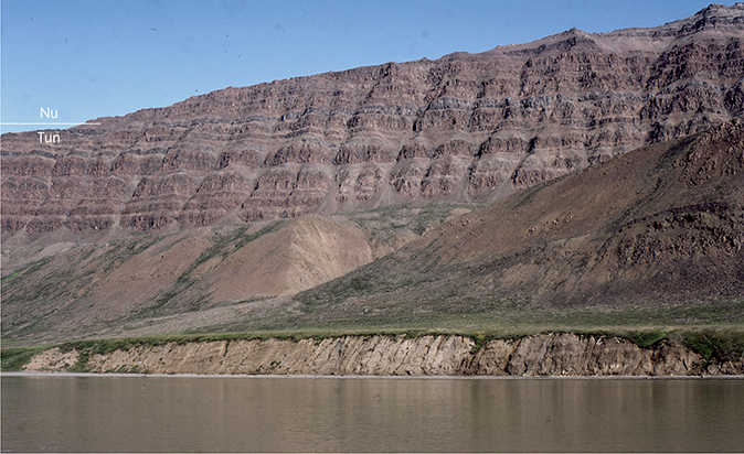
Fig. 44 Yellow and dark grey sediments of the Kuugaartorfik Member dipping west, well exposed in the 8 m high coastal cliff on the north side of the Innerit inlet on the peninsula of the same name. The lava succession in the mountain wall above the sediments belongs to the Tunuarsuk (Tun) and Nuuit (Nu) Members. Profile 37 (Fig. 13) was taken along the shoulder of the wall, which leads up to the 894 m high Nuup Qaava mountain. Photo: Asger Ken Pedersen.
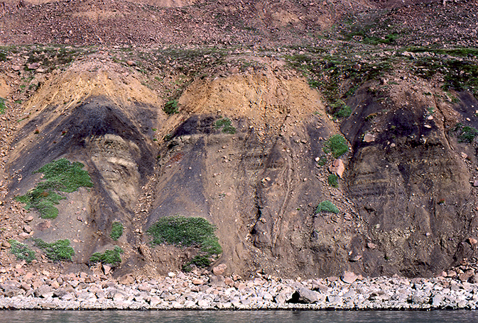
Fig. 45 Siltstone-dominated sediments of the Kuugaartorfik Member on the north coast of the Innerit inlet. The cliff is c. 8 m high. Photo: Asger Ken Pedersen.
On the south-eastern coast of the Innerit peninsula, the Kuugaartorfik Member is identified where the top of the picrites is overlain by yellow sand, which is partly concealed by scree of volcanic material (Figs 31, 41, 46). The exposed thickness of the member is 50–100 m, but the total thickness must be greater. On the geological map, the top of the member was placed c. 100–300 m above the base in the eastern part of the occurrence. Thereby the member occupies a plateau from 300 to 500 m a.s.l. below the steep mountainside with massive basalts of the Tunuarsuk Member. Entablature lavas and hyaloclastites of the lower part of the Tunuarsuk Member may thus have been included in the ‘intravolcanic sediments’ shown on the 1:100 000 map.
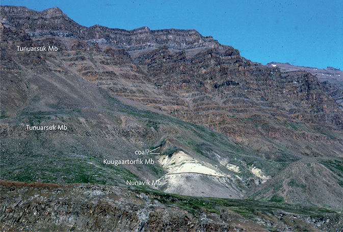
Fig. 46 White quartzofeldspathic, poorly consolidated sandstones of the Kuugaartorfik Member overlying grey pahoehoe lava flows of the Nunavik Member of the Vaigat Formation. The Kuugaartorfik Member is topped by a black layer of sediment, probably rich in coal, and overlain by lava sheet flows of the Tunuarsuk Member. South-eastern Innerit peninsula beneath the Paannivik mountain; compare with Fig. 31. Photo: Asger Ken Pedersen.
The Kuugaartorfik Member is strongly reduced in thickness or missing in the central part of Svartenhuk Halvø. The member has a greatly reduced thickness at Peak 1180 m on the west side of the Nerutusoq valley (Pulvertaft 1966; Loc. L in Fig. 6). A conglomerate with volcanic pebbles occurs south-west of Simiuttap Kuua. The member has not been identified at the Tunuarsuk mountain.
Sediments possibly belonging to the Kuugaartorfik Member. A slipped block with at least 10 m of a bedded, coarse volcanogenic sediment with coal clasts is present at sea level by Qaqqap Qaa. At 190 m a.s.l. above a scree, a similar sediment including coal clasts is referred to the Kuugaartorfik Member (Fig. 13, profile 38). It is overlain by lava sheets, pillow lava and hyaloclastites of the Tunuarsuk Member. At 300–340 m in the same profile a volcaniclastic breccia interpreted as a massflow deposit is referred to the Tunuarsuk Member and described later.
A number of other sediment horizons occur at or near the boundary between the Vaigat and Svartenhuk Formations. A black sediment horizon (tuff?) 5 m in thickness is present on top of the Vaigat Formation in the south-western area on eastern Aputituut (Fig. 10, profile 22) and extends 8 km farther to the south. A black, coarsely fissile sediment and tuff horizon 15 m in thickness is present at the boundary between the Nunavik and Tunuarsuk Members at the south coast west of Tartuusaq (Fig. 16).
Origin of the sediments. The sediments of the Kuugaartorfik Member apparently represent a break in the volcanism and a tectonic event in the northern areas. Presumably the basement to the east was uplifted, and ensuing erosion coupled with flooding led to deposition of quartzofeldspathic sand, mud and coal seams in fluvial plains and lakes in lows in the irregular basement surface and on the exposed surface of the Vaigat Formation. Evidence for tectonic movements after the volcanism of the Vaigat Formation is provided by the angular unconformity between the Vaigat Formation and the Svartenhuk Formation as described here. The mass-flow-like volcanic deposits at Qaqqap Qaa and south-east of Umiiarfik (Loc. K in Fig. 6) also suggest a period of erosion and significant local topography. The volcanogenic sediments mostly appear to be reworked hyaloclastite material and rounded blocks of basalt, which may have been extruded contemporaneously farther south or west.
It appears that the early eruptions of the Tunuarsuk Member in southern Svartenhuk Halvø took place simultaneously with the deposition of the Kuugaartorfik Member in northern Svartenhuk Halvø, and that the volcanic rocks arrived later in the northern areas.
Boundaries. The lower boundary is placed at the first occurrence of clastic sediments, including tuffaceous deposits, overlying the main series of picritic lavas of the Nunavik Member or directly lying on the Precambrian basement.
The upper boundary is placed at the base of the massive succession of basalts of the Tunuarsuk Member, although yellow sand sediments similar to those of the Kuugaartorfik Member occur higher in the sequence with very reduced thicknesses. From a distance, and even close by, it may be diffucult to distinguish between brown soil and palagonitic sediments of the Kuugaartorfik Member and hyaloclastites of the Tunuarsuk Member.
Geological age. Paleocene (Selandian), close to 60 Ma, bracketed between the 40Ar/39Ar ages of 61.08 ± 0.56 Ma for the lower Vaigat Formation (Chauvet et al. 2019) and 60.31 ± 1.39 Ma for the lowest Tunuarsuk Member (Larsen et al. 2016).
Correlation. None known.
Tunuarsuk Member
New member
History. The Tunuarsuk Member is shown as the units βf3 and βf4 on the geological map 71 V.1 Syd Igdlorssuit (Larsen 1983). The member is shown as the unit β1 on the geological map 71 V.1 Nord Svartenhuk (Larsen & Grocott 1991).
Name. After the 1260 m high mountain Tunuarsuk in the northern part of central Svartenhuk Halvø. The member is here well exposed from its base on the south-east side of the mountain to its upper boundary where it is overlain by the Nuuit Member.
Synonymy. The informal ‘middle formation’ of Larsen (1981a) and Holm et al. (1993).
Distribution. The Tunuarsuk Member is present in a S–N-extending area on Svartenhuk Halvø from the south coast to Umiiarfik; it extends northwards on Innerit and Qeqertaq and eastwards in a widespread but dissected capping on the high Precambrian basement (Fig. 6). The member marks the onset of extrusion of voluminous lavas that overstepped the Cretaceous boundary fault system and spread to the north and east. The member is found as far north as at 72°20′N on Qeqertaq (Marraarnaq, profile 42) and the inner Ukkusissat Fjord, but not at Pannertuup Qaqqaa (profile 40). Farther north its presence is undetermined. To the east, recent hand-held aerial photographs (see also Fig. 49) and geological maps (Guarnieri et al. 2022a, b) show that the Tunuarsuk Member extends east across Ukkusissat Fjord to Qaarsorsuaq and farther as a series of grey hyaloclastites and lava flows resting on Precambrian basement and in some places on sediments of unknown character. The series can be followed east to Inngia Isbræ but not farther (Fig. 5). It has not been visited on the ground.
Type section. Paannivik (profiles 64a and b) on the south coast of Innerit (Figs 9, 13, 41; coordinates in Appendix 1). The lower and middle parts follow the south-western edge of the Niaqornaq ridge (profile 64b) from sea level where a thick basalt lava flow with columnar jointing is present, to a height of 575 m a.s.l., while the upper part (profile 64a) follows the edge of the glacier valley north of Paannivik from 515 m to 750 m a.s.l.. The base of the member must be just below sea level in the profile itself and is exposed in the cliffs 3.5–9 km north-east of the profile, where the top of the Kuugaartorfik Member is exposed.
Reference sections. Tunuarsuk (profile 51); this does not include the basal 50–100 m, which, however, are exposed just 2 km farther east. Kuugaartorfik (profile 44c), where both the lower and upper boundaries are exposed. Aputituut Qaqqaat (profile 31) in the southern area, where the member comprises many more thin pahoehoe flows than in the northern areas. Profiles in Figs 11, 12; coordinates in Appendix 1.
Thickness. A maximum thickness of c. 850 m is found on the south coast of Svartenhuk Halvø between Tartuusaq and Illerusat Qaqqaat (Fig. 16). Thicknesses are reduced in central Svartenhuk Halvø to between 500 m (e.g. at Oqaasaq south of Tunuarsuk) and 380 m in the mountains between Qiterlikassak and Usuit Kuussuat, possibly because this area formed a topographic high. To the north, the member is c. 700 m thick at Tunuarsuk; in southern Innerit, it is 750 m thick in profile 64 on the western shoulder of the Paannivik mountain (Fig. 13) but thins to 300–400 m in south-eastern Innerit above the lava shield of the Vaigat Formation. North of 72°N, the member is c. 500 m thick on western Innerit (Nuup Qaava), >470 m on eastern Innerit (Qaqqap Qaa), and >40 m in northern Qeqertaq (Marraarnaq). Eastwards on the Precambrian highland, thicknesses are between 600 and 450 m at Kuugaartorfik, Siuteqqut and Peak 1430 m. Farther to the east, the member is around 300 m thick at Peak 1625 m, Peak 1370 m and Peak 1829 m (Fig. 7). On the Precambrian highland between Siuteqqut Kuuat and Kangiusap Aaffaa, where the overlying Nuuit Member is not preserved, the Tunuarsuk Member has been at least 300–600 m thick, dependent on the topography and elevation of the basement.
Lithology. In the following, the subaerial and subaqueous lithologies of the member are described separately.
Subaerial lithologies. The subaerial lava flows of the Tunuarsuk Member are mostly brown- or grey-weathering, plagioclase-phyric or aphyric basalt lava flows of either compound pahoehoe or sheet flow type, interspersed with dark grey to greenish grey, olivine-rich compound pahoehoe flows of magnesian basalt and subordinate picrite (Fig. 47). A few flows appear to be welded spatter flows that presumably occur close to eruption sites.
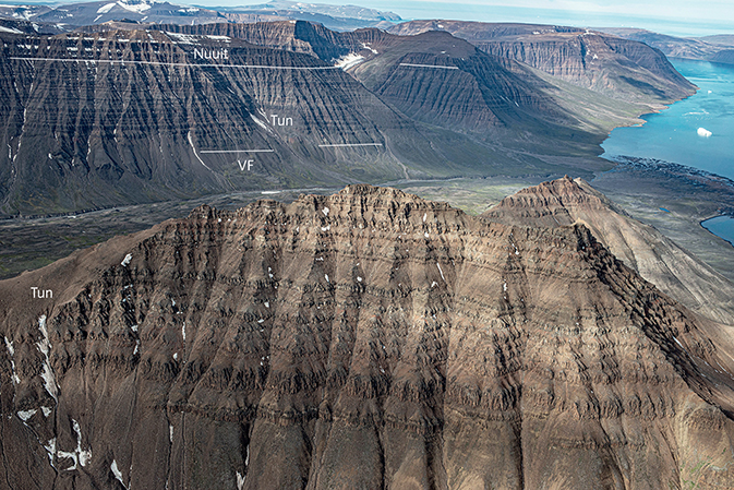
Fig. 47 Lava flows of the Tunuarsuk Member comprising intervals with massive sheet flows interspersed with intervals with thin, crumbling compound flows. Height of foreground field of view c. 400 m. In the background, the exposed lava succession comprises the Vaigat Formation (VF), the Tunuarsuk Member (Tun) and the Nuuit Member (Nuuit) in the 1000–1170 m high mountains. Northern Svartenhuk Halvø looking south-west, with Umiiarfik fjord to the right. Photo: Kristian Svennevig.
The sheet flows are 5–80 m thick, whereas thin pahoehoe lobes form compound flow groups 10–130 m in thickness. The average lava flow thickness in the individual measured profiles is 9–25 m on Svartenhuk Halvø, with the thinner flows dominating in the southern and central areas (average 14 m) and the thicker flows dominating in the northern areas (average 22 m). Farther to the north (profile 37, Nuup Qaava) and north-east (profile 38, Qaqqap Qaa) the average lava flow thickness increases to 33 m and 37 m, respectively, indicating ponding of the lava flows in low-lying areas. Sheet flows dominate here (Figs 44, 48).
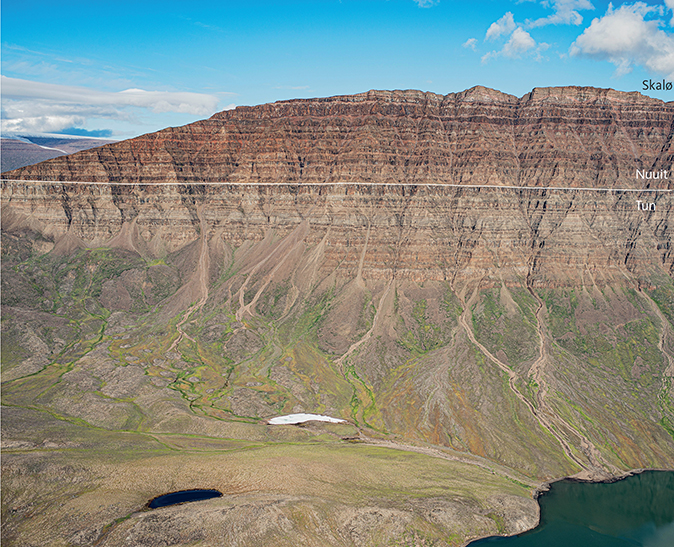
Fig. 48 The lava succession in the steep east wall of Qaqqap Qaa, eastern Innerit peninsula. Profile 38 runs along the ridge to the left through 480 m of light brownish grey Tunuarsuk Member (Tun) flows (left of photo) and 390 m of brown Nuuit Member flows. Light yellowish flows of presumed Skalø Member were observed from a distance overlying the Nuuit Member but were not sampled. Note the lack of exposures on the lower slopes, where both Precambrian basement and sediments of the Kuugaartorfik Member may be concealed. The water in the lower right-hand corner is the Sullua fjord; the peak of Qaqqap Qaa to the right is at 1210 m altitude. Photo: Erik Vest Sørensen.
The plagioclase-phyric basalts contain glomerocrysts up to 10 mm in size of plagioclase laths intergrown with small olivine grains. The groundmass of the basaltic compound pahoehoe flows is fine- to medium-grained and vesicular, with dark green alteration products possibly after glass; from a distance such greenish rocks may be mistaken as olivine-rich types. The basaltic compound pahoehoe flows have plagioclase and olivine phenocrysts that are unevenly distributed between the individual flow lobes; this may indicate magma pulses from stratified magma chambers with very fluid magmas or crystal segregation during flowage, or both. In any case, it indicates a close genetic relationship between the olivine-poor and olivine-rich and picritic magmas. We also consider that the sheet flows and compound flows are closely related genetically. Differences are caused by different magma viscosities, commonly in connection with different degrees of evolution. Less evolved, Mgrich magmas tend to form compound pahoehoe flows, whereas more evolved, Mg-poor and Ti-rich magmas tend to form massive sheet flows.
The lava pile can be roughly divided into three intervals in which lava flows of different morphologies dominate. Boundaries between the intervals are gradational.
The lower interval (1) comprises a 90–200 m thick succession of brown-weathering sheet flows, mostly of plagioclase-phyric basalt. Compound pahoehoe flows are subordinate. Particularly in southern Svartenhuk Halvø, the basal flows of the Tunuarsuk Member form a group of thick, brown sheet flows, seen for example in the coastal profiles at Kap Cranstown and Tartuusaq (Figs 14, 16). To the north, in the Umiiarfik region, the lower part is in semi- or subaqueous facies with two thick entablature lavas constituting the base of the member over a large area.
A middle interval (2) forms a 80–370 m thick succession of grey-weathering, interdigitating compound pahoehoe flows and sheet flows.
The upper interval (3) is a 190–310 m thick succession dominated by dark greenish-grey compound pahoehoe flows: sheet flows are subordinate. This interval comprises olivine-phyric basalt and a few picrites alternating with grey, aphyric or plagioclase-phyric basalts.
In the northern area, a division into a lower succession (interval 1 and 2) of mainly olivine-poor basalts (MgO <8 wt% and TiO2 >1.80 wt%) and an upper succession (interval 3) of mainly olivine-phyric basalts (MgO >8 wt% and TiO2 <1.80 wt%) is possible from both field observations and chemical analyses. Table 1 gives thicknesses of the lower and upper successions of the member together with the number of lava flows and average thicknesses.
| Profile | Total member thickness | Lower part of member | Upper part of member | Whole member | ||||||
| Thickness | No.of flows | No.of flows | Ave. flow thickness | Thickness | No.of flows | No.of flows | Ave. flow thickness | Accumulated thickness | ||
| No. Name | MgO ≥8.0% | MgO <8.0% | MgO ≥8.0% | MgO <8.0% | MgO ≥8.0% | |||||
| 39 Peak 1540 m | 320 | 125 | 0 | 3 | 42 | 195 | 3 | 4 | 28 | 94 |
| 38 Qaqqap Qaa | 470 | 263 | 0 | 5 | 53 | 207 | 3 | 1 | 52 | 154 |
| 37 Nuup Qaava | 434 | 254 | 0 | 7 | 36 | 180 | 3 | 3 | 30 | 70 |
| 47 Peak 1430 m | 440 | 120 | 1 | 4 | 24 | 320 | 9 | 4 | 25 | 214 |
| 44c Kuugaartorfik | 570 | 320 | 1 | 12 | 25 | 250 | 9 | 6 | 17 | 140 |
| 64 Paannivik | 810 | 575 | 1 | 24 | 23 | 235 | 10 | 2 | 20 | 170 |
| 50 Umiiarfik South | >520 | >330 | 1 | 16 | 19 | 190 | 8 | 4 | 16 | 114 |
| 51 Tunuarsuk | 600 | 325 | 5 | 11 | 20 | 275 | 10 | 4 | 20 | 206 |
| 30 Ivissukkat Itin.a | 294 | 134 | 1 | 8 | 15 | 160 | 10 | 4 | 11 | 98 |
| 29 Peak 1050 m | 334 | 158 | 3 | 5 | 20 | 176 | 8 | 5 | 14 | 138 |
| 31 Aputituut Qaq. | 420 | 90 | 0 | 7 | 13 | 330 | 4 | 10 | 24 | 142 |
| 22 Akuleqqut | 400 | 150 | 1 | 15 | 9 | 248 | 8 | 7 | 16 | 160 |
| 25 Equuttat K.K b. | >330 | >157 | >3 | >9 | 13 | >173 | 3? | 4? | 25 | 108 |
| No.: number. Ave.: average. a Ivissukkat Itinnerat. b Equuttat Killiit Kuuat. All thicknesses in metres. Distinction between flows with MgO <8.0% and MgO ≥8.0% is based on a combination of chemical analyses and visual criteria such as phenocrysts, colour and morphology. Profiles are arranged from north to south. | ||||||||||
Whereas thick lava flows of both types dominate in the northern area, lava flows in the southern area are mostly of compound pahoehoe type and generally thinner than in the north. In addition, there seems to be a more frequent interdigitation between MgO-poor and MgO-rich basalts. Thus the Tunuarsuk Member may have been built up by interdigitating flows from two major volcanic sources, one of them with a fluid magma in which transitions from olivine-rich to plagioclase-phyric flow units, or the reverse, can be observed within the same compound lava flow. A southern origin for this suite is suggested. The northern dominance of MgO-poor sheet flows in the lower part of the member may reflect a northern origin of this lava type or alternatively that the large erupted volumes filled topographic lows to the north and east. In this case, either the MgO-poor lavas were of the sheet flow type throughout, or degassing of more fluid magma produced the more viscous lava flows. A transition between the two types within one sheet flow has, however, not been seen. Remarkably, the highest flow in the member on eastern Innerit (at Qaqqap Qaa) is a picrite with 12.0 wt% MgO that forms a massive sheet flow 50 m in thickness (see Fig. 52).
Subaqueous lithologies. East and north of the Cretaceous boundary fault system subaqueous lava flows, pillow lavas, pillow breccias, hyaloclastites and invasive lava sheets are widespread at the base of the member (Figs 49, 50). All indicate a general transport direction towards the north. This implies that the whole northern area was more or less flooded before the extrusion of the Svartenhuk Formation; widespread wetlands existed on the eroded and irregular surface of the Precambrian basement and also on top of the Vaigat Formation.
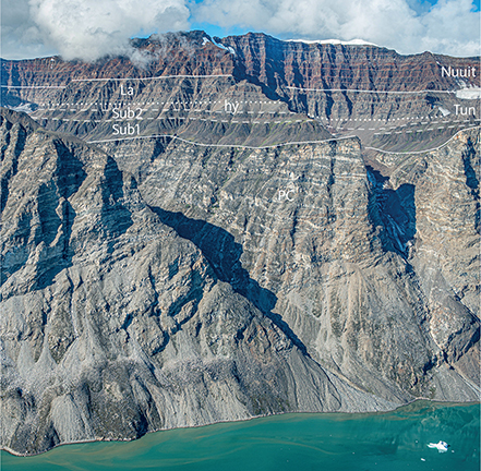
Fig. 49 Volcanic rocks of the Svartenhuk Formation overlying Precambrian metasediments of the Karrat Group (PC) at around 1000 m altitude. The volcanic succession of the Tunuarsuk Member (Tun) comprises two dark subaqueous lava flows in entablature facies (Sub1 and Sub2), overlain by light grey hyaloclastites (hy), which presumably displaced the water in a local basin and are overlain by associated subaerial lava flows (La). The overlying brown flows of the Nuuit Member are all subaerial. The uppermost flows are grey and are assumed to belong to the Skalø Member, but this part of the succession has not been visited on the ground. There are traces of sediment at the base of the volcanic succession and between the subaqueous flows. Western wall of Ukkusissat Fjord around 72°05′N, 53°40′W; the top level in the background is around 1700 m altitude. Photo: Erik Vest Sørensen.
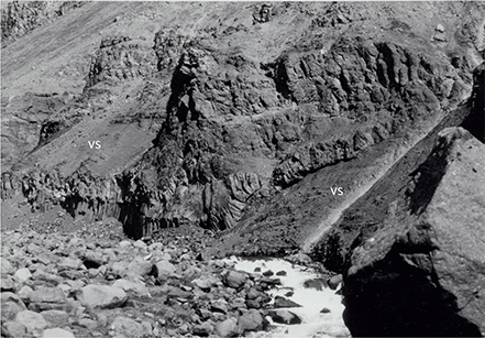
Fig. 50 Irregular, columnar-jointed lava sheets invading volcanogenic sediments (vs). Lower part of the Tunuarsuk Member, base of profile 38, Qaqqap Qaa, at 190 to c. 220 m altitude (Fig. 10).
The thickness of the subaqueous deposits increases towards the north, indicating greater water depths here. Hyaloclastites and subaqueous lava flows are now exposed from sea level to 1300–1400 m a.s.l. due to uplift and postvolcanic tilting of the lava pile (Fig. 5).
In the Qaqqap Qaa profile (38; Fig. 13) a coarse volcanogenic sediment with coal clasts at 190–200 m a.s.l. is referred to the Kuugaartorfik Member. It is overlain by Tunuarsuk Member pillow lava and hyaloclastites with invasive lava sheets at the base (Figs 13, 50). The subaqueous succession is 140 m thick; the upper 40 m is a volcaniclastic, palagonite-rich breccia with transported basalt blocks up to 40 cm in diameter (Larsen 1981b, fig. 26), probably a mass-flow deposit (Fig. 13). It is here referred to the Tunuarsuk Member but may as well represent the uppermost part of the Kuugaartorfik Member. The mass-flow activity may have been caused by movements on a nearby fault in Sullua, perhaps connected to the fault in Umiiarfik inferred by Larsen & Pulvertaft (2000, p. 22).
In the type profile at Paannivik (64) just south of 72°N the basal lava flows have solidified under subaqueous to semi-submerged conditions forming entablature lavas. Entablature flows are also seen at the present sea level on Kigataq island west of Innerit (Fig. 51). Megapillows up to 4–5 m in diameter occur in the valley east of the Innerit inlet.
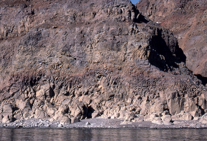
Fig. 51 Lava flow with a basal colonnade of coarse columns along the shore, changing upwards to slender columns in an entablature zone with a wavy column pattern. The overlying part of the flow is thoroughly brecciated. Despite these signs of emplacement into water, the flow is capped by a red-oxidised sediment layer (white arrow) indicating that the top of the flow was above water level after emplacement. Height of field of view c. 15 m. East side of Kigataq island. Photo: Asger Ken Pedersen.
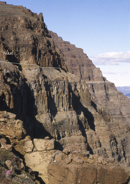
Fig. 52 The boundary between lava flows of the Tunuarsuk Member (Tun) and the more brownish lava flows of the Nuuit Member in profile 38 (Qaqqap Qaa). The thick, columnar-jointed uppermost flow in the Tunuarsuk Member is Mg-rich with 12.0 wt% MgO, i.e. it classifies as a picrite despite its massive morphology. The flow is 50 m thick (Fig. 13). The boundary is seen at a distance in Fig. 48.
Subaqueous deposits do not occur in the central and southern areas.
Eruption sites. Eruption sites for the Tunuarsuk Member have rarely been observed. Welded spatter flows indicating proximity to an eruption site occur in profiles in south-central Svartenhuk Halvø, e.g. at Peak 1050 m (profile 29 at 885–900 m, not shown) and Aputituut Qaqqaat (profile 31 at 750–760 m, Fig. 11).
Also in profile 31 at 872–890 m a deposit of more or less welded, glass-rich, palagonitised tuff 18 m in thickness forms the uppermost unit in the Tunuarsuk Member. The deposit has in part the character of a basaltic ignimbrite and is recognised in other profiles in southern Svartenhuk Halvø. An analysis of the glass (sample 164917 from profile 18 at Kussineq) with relatively high MgO (9.1 wt%) and low TiO2 (1.9 wt%) confirms the affiliation to the Tunuarsuk Member. The deposit is probably related to an eruption site in the area at 71°31′N, 55°00′W (Fig. 26). Here a one-kilometre-long, WNW–ESE-oriented, 10 m wide, dyke-like row of ochre-coloured palagonite breccias with black glass clasts, presumably near-surface crater deposits, cuts lava flows of the Tunuarsuk Member. The row is indicated by a line of stars on the geological map of Larsen & Grocott (1991). The breccia is interpreted as having formed by interaction between a magma erupting through a fissure and ground or surface water.
Chemistry and chemostratigraphy. The Tunuarsuk Member comprises tholeiitic basalts with 5–10 wt% MgO, magnesian basalts with 10–12 wt% MgO and scattered picrites with 12–22 wt% MgO. The average MgO content is 8.4 wt%. TiO2 is in the range 1.1–3.3 wt% with an average of 1.8 wt%. A few flows scattered throughout the area are distinctly enriched in incompatible elements, and very few flows are crustally contaminated (see the Nomenclature section for definition of these types). Representative analyses are given in the Geochemistry chapter.
The most complete chemical profiles are those of Paannivik (profile 64), Umiiarfik South (profile 50), Tunuarsuk (profile 51), Kuugaartorfik (profile 44c), Peak 1430 m (profile 47) and Ivissukkat Itinnerat (profile 30). There is generally a decreasing TiO2 content with height in all profiles (Fig. 42), ranging from about 2.5 wt% TiO2 (maximum 3.3 wt%) in the lower part to about 1.5 wt% TiO2 in the upper part with the more magnesian basalts. To the north, where lava flows with higher TiO2 contents are lacking, the variation is best described as a slightly bumpy trend of decreasing TiO2 with height. In contrast, profile 30 in the central area exhibits two consecutive intervals each starting with high and ending with low TiO2 values, followed by a third interval with almost constant TiO2. The different patterns of stratigraphic development in the northern and southern areas may indicate the existence of two separate or poorly connected, deep-seated magma chambers.
Boundaries. The base of the Tunuarsuk Member is defined by the first occurrence of brown, olivine-poor, dominantly plagioclase-phyric lava flows or hyaloclastites overlying the picrites of the Vaigat Formation. In areas where sediments of the Kuugaartorfik Member are present, the two members interdigitate. In the central area (Usuit Kuussuat) a single, dark grey, sparsely olivine-phyric to aphyric basalt flow (βo2) interbedded near the top of the picrites has been included in the underlying Nunavik Member. The Tunuarsuk Member appears to overlie the Nunavik Member conformably in most areas, although there are exceptions as described in Boundaries of the Svartenhuk Formation.
The upper boundary has been placed at the top of the succession of the olivine-phyric basalts underlying thick, brown basalts of the Nuuit Member (Figs 48, 52).
Geological age. Paleocene (Selandian to Thanetian). Radiometric (40Ar/39Ar) age determinations of the Tunuarsuk Member yielded ages of 60.31 ± 1.39 Ma (Larsen et al. 2016) and 59.78 ± 0.41 Ma (Chauvet et al. 2019) for the lower part of the member and 59.05 ± 0.61 Ma for the middle part of the member (Larsen et al. 2016).
Correlation. The Tunuarsuk Member is suggested to be time-equivalent to the Qeqertalik Member on Ubekendt Ejland and the Nûluk Member on Nuussuaq west of the Itilli fault (Larsen et al. 2016; Fig. 3).
Nuuit Member
New member
History. On the geological map 71 V.1 Syd Igdlorssuit (Larsen 1983), the Nuuit Member is included in the unit βf6. On the geological map 71 V.1 Nord Svartenhuk (Larsen & Grocott 1991), the member is partly shown as the green unit β2. In southern Svartenhuk Halvø where the boundary between the Nuuit Member and the Skalø Member (β3) was not mapped, lavas of the Nuuit Member are included in the blue unit (β3) and labelled β2.1. In the north-eastern area of the map, an upper boundary of the Nuuit Member was not definable during mapping, and here the Nuuit Member has been given the blue colour of the Skalø Member and is not labelled.
Name. After Nuuit, the point forming the northern corner of the inlet Amitsup Sullua on the north-west coast of Svartenhuk Halvø. The member is well exposed on the slopes of the nearby mountain Nuuit Qaqqaat.
Distribution. The Nuuit Member has been recognised in southern, central and northern Svartenhuk Halvø from Tasiusap Imaa in the south to the north coast and farther north on Innerit and Qeqertaq and the coastal islands (Fig. 6). In north-western Svartenhuk Halvø (north of Maligissap Kuua) and south-western Skalø, the member is below exposure level. The member is present in south-western Svartenhuk Halvø (Qinnivik) west of the large fault through the Arfertuarsuk inlet, and it is also present in southern Svartenhuk Halvø north of Tasiusap Imaa; however, in these two areas, it has not been mapped because of poor exposures and strong faulting. On the map of Larsen & Grocott (1991) the Nuuit Member in these two areas is included in the western part of the Skalø Member area (β3). In Fig. 6, we have drawn a tentative boundary between the Nuuit and Skalø Members in southern Svartenhuk Halvø, but this was not possible for the Qinnivik area.
In eastern Svartenhuk Halvø, the Nuuit Member is eroded away west of the Cretaceous boundary fault system. The member reappears east and north-east of the boundary fault where it overlies the Tunuarsuk Member (profiles 44c, 47 and 38). North of around 72°15′N (profiles 40 and 65) the Nuuit Member has overstepped the Tunuarsuk Member and rests directly on basement gneiss (Figs 6, 13). Its presence north of 72°20′N is undetermined. In the unvisited areas east of Ukkusissat Fjord, recent aerial photographs (Fig. 49) and geological maps (Guarnieri et al. 2022a, b) show that a series of grey flows of presumed Tunuarsuk Member is overlain by brown lava flows with a visual character similar to flows of the Nuuit Member to which we presume they belong. These brown flows extend east to Inngia Isbræ and farther (Fig. 5; Guarnieri et al. 2022a, b). East of Inngia Isbræ the Nuuit Member appears to be the only member of the Svartenhuk Formation present. A single reconnaissance sample from a nunatak above the headland of the glacier Umiammakku Sermia at 72°04.2′N, 51°54.5′E (Fig. 5, sample 566505) is virtually chemically identical to the uppermost flow in the Salliaruseq profile (65) at 72°25.0′N, 53°47.9′E (sample 566511). Considering the distance of 77 km between the two localities it is possible, but not provable, that the two represent the same lava flow.
Type section. Paannivik (profile 64a, Figs 13, 41) on southern Innerit. Here the Nuuit Member is present between 750 m and 1210 m a.s.l., and both base and top of the member are exposed. Coordinates in Appendix 1.
Reference sections. Nuuit Qaqqaat (profile 52) between 120 m and 600 m a.s.l.; the base of the member is not exposed (Fig. 53). Umiiarfik South (profile 50) between 650 m and 1000 m a.s.l.. This profile is of relatively easy access near the coast (Fig. 27), and both base and top of the member are exposed. Profiles in Fig. 12; coordinates in Appendix 1.
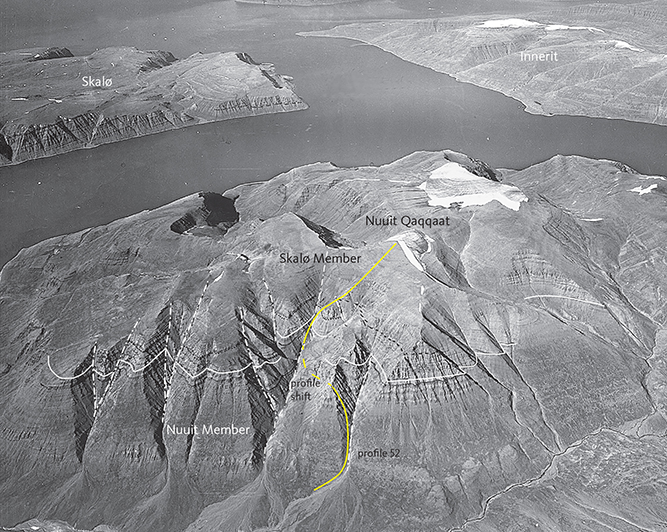
Fig. 53 The Nuuit and Skalø Members of the Svartenhuk Formation at Nuuit Qaqqaat, looking NNW. The white line is the boundary between the two members. Some local marker flows are traced in black dotted lines on the original photograph. Profile 52 (Fig. 12) is indicated with a yellow line. Height of section 780 m. Geodetic Institute oblique aerial photograph 526HN/5641.
Thickness. The member is 460 m thick in the type section. Thicknesses of 300–500 m are commonly found, e.g in the Nuuit Qaqqaat, Umiiarfik South and Aputituut profiles (Figs 11, 12; Table 2). Thicknesses in the northern areas are similar or greater, with 460 m at Paannivik, >380 m at Nuup Qaava, >400 m at Qaqqap Qaa, and >550 m at Marraarnaq. In the far north-east the formation has even greater thicknesses, with >580 m at Salliaruseq and >630 m at Pannertuup Qaqqaa; the latter profile comprises thick sheet flows, subaqueous entablature flows and a hyaloclastite bed more than 100 m thick that was fed by a compound pahoehoe flow. The increased thicknesses in the north are probably caused by ponding of flows in more or less water-filled depressions. The lava flows, or at least some of them, came from the south as indicated by the north-dipping foreset-bedding of the hyaloclastites north of Qaqqap Qaa and at Pannertuup Qaqqaa.
Lithology. The Nuuit Member is dominated by brown-weathering aphyric and plagioclase-phyric basalt flows that generally form relatively thick sheet flows with thick scoriaceous tops with reddish-orange colours (Fig. 54). Most flows are subaerial but subaqueous units are present, mainly in the northern areas, e.g. hyaloclastites at Pannertuup Qaqqaa (Fig. 13, profile 40). A few tuff layers are also found.
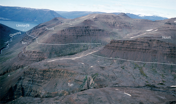
Fig. 54 Characteristic brown, massive lava flows of the Nuuit Member overlying thinner and more variable lava flows of the Tunuarsuk Member (Tun). Northern Svartenhuk Halvø with the Qooroq valley to the left, looking north towards the Umiiarfik fjord. Photo: Asger Ken Pedersen.
In the type profile at Paannivik, the lower part of the Nuuit Member is dominated by sheet flows up to 50 m in thickness of plagioclase-glomerophyric and less frequent aphyric basalt. The lowest flow has entablature structure. Higher up there are a few compound pahoehoe flows c. 30 m thick. In the profile at Nuuit Qaqqaat a pillow horizon is present. In the Umiiarfik South profile several tuff beds up to 1 to 2 m thick are present.
The northernmost coastal exposures of lava flows are found around 72°22′N on the western tip of the Qulassivik peninsula, 20 km east of the Kangersuatsiaq settlement (Prøven, Fig. 7). Here lava flows of the Nuuit Member ran into water and developed megapillows up to 5 m in diameter, spectacular colonnades, tiered colonnades (Figs 55, 56) and entablatures before they were banked up against steep hillocks of the Precambrian basement (Fig. 57).
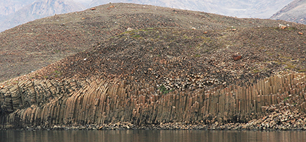
Fig. 55 Thick lava flow with a 20–25 m high colonnade with bent column tops. Nuuit Member at Asungasungaa, west coast of Qulassivik peninsula, 9 km east of the Kangersuatsiaq (Prøven) settlement. Photo: Asger Ken Pedersen.
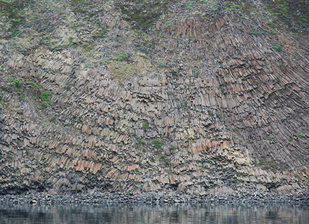
Fig. 56 Multi-tiered columns in a thick, ponded lava flow, probably the same flow as in Fig. 55. Height of section 20–30 m. Nuuit Member at Asungasungaa, west coast of Qulassivik peninsula, 9 km east of the Kangersuatsiaq (Prøven) settlement. Photo: Asger Ken Pedersen.
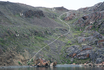
Fig. 57 Three successive lava flows (La) of the Nuuit Member banked up against a steep hill of Precambrian basement gneiss (PC). South-west coast of Qulassivik peninsula, 10 km ESE of the Kangersuatsiaq/Prøven settlement. Photo: Asger Ken Pedersen.
Some horizons form the following markers:
- Two lava flows in the lower part of the member contain large plagioclase glomerocrysts with stellate outlines as well as individual platy plagioclase crystals c. 1 cm long or larger (profiles 38, 39, 47, 64).
- Two thick lava flows contain c. 0.5 cm plagioclase glomerocrysts together with platy olivine phenocrysts; these occur at Paannivik, on Skalø and on the south side of Uiarsaariaq (profiles 64, 41b and 54).
Eruption sites. The average lava flow thickness in individual profiles south of 72°N varies between 15 and 24 m, with the lower values found in southern and central Svartenhuk Halvø and the larger values on the Innerit peninsula. Average lava flow thicknesses north of 72°N range from 23 to 43 m (Table 2). This situation is similar to that in the Tunuarsuk Member of the same profiles, suggesting that the eruption sites for both members were situated close to or within the southern areas, giving rise to many small and thin flows in the south, whereas only the most voluminous flows reached north to the Innerit area and farther to the northern and north-eastern areas.
A volcanic plug was found by Münther (1973) in the coastal cliffs on the western side of the Arfertuarsuk inlet in south-western Svartenhuk Halvø (Figs 26, 58). The plug cuts vertically through lava flows of the Tunuarsuk Member and one or two flows of the Nuuit Member. It has a doleritic core and a chilled margin with weak columnar jointing perpendicular to the outer contacts. Towards the highest flow in contact with the plug, a purple to blackish agglomerate is developed that passes laterally into a lava flow, one of the lowest flows in the Nuuit Member. Higher lava flows are unaffected. In the scree below the plug some gabbro nodules were found. Further description is given by Münther (1973, p. 15).
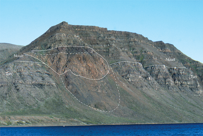
Fig. 58 Volcanic plug feeding one of the lowest lava flows in the Nuuit Member near the boundary to the Tunuarsuk Member (Tun). The plug is traced in white; the dashed lines are approximate. The central plug is light brown with a diameter of c. 150 m. The upper zone is a purple agglomerate that passes laterally (to the left) into a lava flow. The character of the lower zone is uncertain; it was described by Münther (1973) as a “mixed contact”. See text for further description. Coastal cliff on the western side of the Arfertuarsuk inlet, south-western Svartenhuk Halvø.
Chemistry and chemostratigraphy. The Nuuit Member comprises tholeiitic basalts with 3.4–11 wt% MgO; the average MgO content is 6.4 wt%. TiO2 is in the range 1.5–3.8 wt% with an average of 2.4 wt%. A few scattered flows are crustally contaminated. The magmas were relatively depleted in incompatible trace elements such as Rb, Ba, Th, U, Nb, and light REE. Some flows in the northern areas are enriched in the same elements, which has stratigraphic significance as discussed in the later section on petrology. Representative analyses are given in the Geochemistry chapter.
A common pattern of TiO2 variation with height in the Nuuit Member is seen in several profiles (Fig. 42). With some irregularities, the lower part of the member shows constant to increasing TiO2 with height, reaching a maximum around the middle of the member. TiO2 decreases in the upper part of the member, until a reversal to increasing TiO2 is seen in a few flows at the top of the member. This is particularly clear in the Nuuit Qaqqaat and Paannivik profiles. If this is a general trend, the upper part with decreasing TiO2 seems to be missing in the Sigguk profile, whereas the reversal at the top is well developed (the lower part of the Nuuit Member is not exposed in this profile). Similarly, the erosional remains of the member in the eastern profiles Kuugaartorfik and Peak 1430 m represent the lowest part of the member, whereas the northern profile at Qaqqap Qaa seems to represent a condensed succession. The Umiiarfik South profile is different, with two cycles of decreasing TiO2 present.
The basalts in the Aputituut profile are characterised by relatively high TiO2 contents of 2.5 to >3.0 wt% in both the Nuuit Member and the overlying Skalø Member (Fig. 42). The boundary between them is placed where the flow morphology changes to flows with yellow-brown top zones and plagioclase aggregates typical of Skalø Member flows.
Boundaries. The lower boundary is placed where the dark greenish-grey olivine-phyric basalts of the Tunuarsuk Member give way to brown sheet flows of plagioclase-phyric and aphyric basalt. The boundary is well exposed and easy to identify in most areas due to the colour contrast between the two members.
The upper boundary is defined by the appearance of grey-weathering, thin pahoehoe lava flows with yellow flow tops of the Skalø Member. The boundary is well exposed in north-western Svartenhuk Halvø around the estuary and river of Amitsup Sullua and Amitsup Kuua (Fig. 59) and on the south coast of Skalø (Fig. 60). The top flow of the Nuuit Member is a distinct, thick, dark brown sheet flow on Skalø and at the coast west of Amitsoq; this is overlain by a thin sheet flow and yellow-topped pahoehoe flows referred to the overlying Skalø Member. In the Nuuit Qaqqaat area, some yellow-weathering lava flows are also present below the top of the member, which is comprised of the same thick, massive, brown lava flow that is the top flow west of Amitsoq. On northern Skalø, the top of the Nuuit Member has been placed on top of 2–3 thick brown lava flows overlying some yellow-weathering flows and overlain by thin yellow flows referred to the overlying Skalø Member.
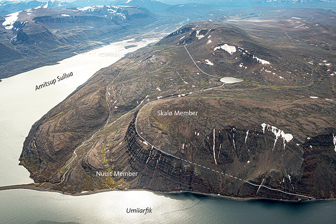
Fig. 59 The upper lava flows of the Nuuit Member and the conformable boundary to the Skalø Member at Amitsoq just west of the Amitsup Sullua inlet, looking SE. The water in the foreground is the Umiiarfik fjord. Note that the lava package west of Amitsup Sullua is tilted 14°W, whereas the lava package east of Amitsup Sullua is nearly flat-lying (Figs 53, 54). Photo: Kristian Svennevig.
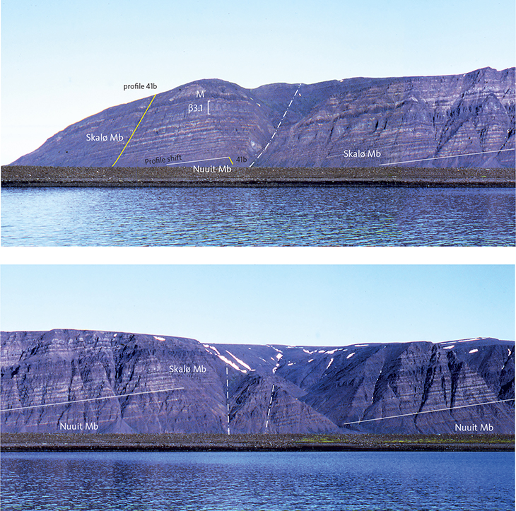
Fig. 60 Light grey lava flows of the Skalø Member overlying massive brown flows of the Nuuit Member on the south-east coast of Skalø. The succession is faulted (dash-dot lines) and dips 10°SW. The location of profile 41b is indicated (yellow line). Marker horizons β3.1 and the dark flow M are described in the text. The coastal section in view is 4.5 km long and the cliffs are 400–450 m high.
The upper boundary has not been mapped in southern Svartenhuk Halvø due to poor exposures and many faults. In this area, the geological map of Larsen & Grocott (1991) shows lavas of the Nuuit Member labelled β2.1 and included in the blue areas of the overlying younger lavas (β3) with no boundary drawn between them.
Geological age. Paleocene (Thanetian). A radiometric (40Ar/39Ar) age determination of the Nuuit Member yielded an age of 58.08 ± 0.59 Ma (Larsen et al. 2016).
Correlation. The Nuuit Member is considered to be time-equivalent to the upper part of the Qeqertalik Member and/or the Tuperssuartâta kûa Member on Ubekendt Ejland, and to part of the Ifsorisok Member on Nuussuaq west of the Itilli fault (Fig. 3; Larsen et al. 2016).
Skalø Member
New member
History. The Skalø Member is included in the unit βf6 on the geological map 71 V.1 Syd Igdlorssuit (Larsen 1983). It is included in the unit β3 on the geological map 71 V.1 Nord Svartenhuk (Larsen & Grocott 1991).
Name. After the island Skalø north-west of Svartenhuk Halvø where the member is well exposed along the south-east and north-west coasts.
Distribution. The Skalø Member has been recognised in north-western and northern Svartenhuk Halvø, Skalø and southern and eastern Innerit. It is inferred to be present across all of western Svartenhuk Halvø, but field relations to the south-west are poorly constrained due to intense faulting and poor exposure. The northern and eastern delimitations are erosional. Recent aerial photographs (Fig. 49) and geological maps (Guarnieri et al. 2022a, b) show remnants of a series of lava flows with a visual character similar to flows of the Skalø Member capping the highest peaks in the area east of Sullua and extending east across Ukkusissat Fjord to Inngia Isbræ but not farther (Fig. 5). These flows rest on brown flows presumed to belong to the Nuuit Member. They have not been sampled, but their stratigraphic position and comparison with Innerit (Paannivik and Qaqqap Qaa) suggest that they belong to the Skalø Member.
As the boundaries to the under- and overlying members have not always been mapped, the areas that represent the Skalø Member on the geological maps (Larsen 1983, βf6; Larsen & Grocott 1991, β3) include parts of the Nuuit Member in southern Svartenhuk Halvø and parts of the Arfertuarsuk Member in western and south-western Svartenhuk Halvø and on Skalø.
Type section. Sigguk (profile 62) on the southern side of the 643 m hill in westernmost Svartenhuk Halvø; the base is at 150 m a.s.l. and the top is at 360 m a.s.l. (Fig. 11; coordinates in Appendix 1). Both base and top of the member are well exposed, see Fig. 64. No other profiles include a well-exposed top of the member.
Reference sections. South-eastern Skalø (profile 41b, Fig. 60) contains a marker horizon of many thin pahoehoe units (mapped as β3.1), which is absent in the type profile at Sigguk. Nuuit Qaqqaat (profile 52, Fig. 53) contains a 300 m long, well-exposed and well-analysed section through the member. Profiles in Fig. 12; coordinates in Appendix 1.
Thickness. The greatest thickness encountered is 460 m, found on Skalø. In the type section at Sigguk, the Skalø Member is 210 m thick. In central and northern Svartenhuk Halvø and Innerit, erosion has left thicknesses from 300 m at Nuuit Qaqqaat to 200 m at Aputituut Qaqqaat to 125 m at Umiiarfik South and 130 m at Paannivik. Thicknesses are summarised in Table 3.
Lithology. The dominant lithology of the Skalø Member is plagioclase-glomerophyric basalt lava flows of either compound pahoehoe or sheet flow type. The phenocryst contents (commonly >10%) are generally higher than in the other members. The glomerocrysts are c. 5 mm in size or larger. A distinctive basalt type contains characteristic platy olivine phenocrysts and commonly also plagioclase aggregates. This type is found in the middle of the member and is present on Skalø and on both sides of the westernmost NW–SE-trending fault on the coast between Amitsoq and Serfat. A similar flow is present on the south-eastern side of the Arfertuarsuk inlet (Fig. 15, sample 165215).
Weathering colours are light grey, and a distinct pale yellow colouring of flow tops occurs in many areas, typically on south-eastern Skalø and east of Amitsup Sullua (Fig. 61). The yellow colour appears to be due to altered glassy flow tops of relatively thin lava flows or flow units. Red flow tops are common in other areas, e.g. in profile 50 (Umiiarfik South). The lavas are more grey on south-western Skalø. Tuff beds are few, and one or two pillow breccias and agglomerates are present on Skalø (profile 41a) and at Nuuit Qaqqaat (profile 52). A single coal seam 0.5 m thick has been recognised on south-eastern Skalø (at 310 m a.s.l. east of profile 41b).
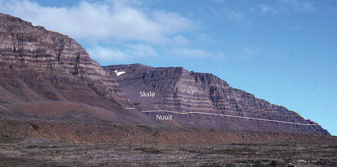
Fig. 61 Lava flows of the Skalø Member with characteristic yellow-tinted, light top zones, overlying brown flows of the Nuuit Member. North-east side of the Amitsup Kuua valley, north-western Svartenhuk Halvø, looking south. The succession is unfaulted and nearly flat-lying, dipping 3°SW. Length of cliff section 2.5 km and height of section c. 300–400 m. Photo: Karl Aage Jørgensen.
The Skalø Member contains two marker horizons, which make correlation possible between Skalø and the coast of Svartenhuk Halvø west of Amitsoq and one horizon that correlates between Skalø (profile 41b) and Sigguk (profile 62).
A marker flow named β3.1 on the map occurs c. 160 m above the base of the member on Skalø (profile 41b, Figs 12, 60). It is a prominent, grey, compound pahoehoe lava flow that is almost aphyric in its lower flow units, whereas the upper flow units have large stellate plagioclase aggregates (‘star basalt’) and a relatively coarse groundmass. This unit is 70 m thick on south-eastern Skalø and 20 m thick at Amitsoq 5 km to the south-east. The flow has higher TiO2 content (>3 wt%) than most other Skalø Member flows and is clearly identified in Fig. 42. Two ‘star basalt’ sheet flows with a combined thickness of 45 m in Qooruusaq (profile 59) have a similar composition and are considered to be part of the same horizon (Fig. 42).
Distinctive, dark flows with platy olivine phenocrysts and commonly plagioclase aggregates occur at two levels in the member on Skalø, one above and one below the β3.1 marker (Fig. 60; the upper dark flow is labelled M) and along the coast between Amitsoq and Serfat.
The uppermost flow of the Skalø Member in the two profiles at Sigguk (62) and Skalø (41b) are compositionally identical and unique for the whole formation (Fig. 42). They have anomalously low TiO2 contents (1.15 wt%) at 7.6 wt% MgO (mg-number 58.7; see the TiO2 diagram in the Geochemistry chapter); Al2O3 (15.4 wt%) and CaO (12.6 wt%) are high but not anomalously so and do not indicate plagioclase accumulation. We consider that these samples, located 19 km apart, represent the same lava flow.
In the Aputituut area where the boundary between the Nuuit and Skalø Members is difficult to trace, the uppermost c. 70 m of the flows in the Aputituut profile (55) have yellow-brown top zones and contain large stellate aggregates of plagioclase phenocrysts; they have therefore been placed in the Skalø Member. They constitute a coherent group of lava flows with high TiO2 contents (2.5–2.9 wt%, Fig. 42) and are very similar to the flows in the Skalø Member marker horizon β3.1. The distance to the latter exposures is c. 25 km, and it is uncertain whether they represent the same horizon.
In the same difficult area in central-western Svartenhuk Halvø, the yellow-weathering colours of the basalts along the river Akuleqqut Kuuat, and their chemical compositions, confirm the presence of the Skalø Member (Jørgensen 1981).
Along the north-eastern side of the Arfertuarsuk inlet, the SW-dipping succession of lava flows consists of dark grey, olivine-bearing flows and yellow-brown pahoehoe flows with a physical appearance and chemical compositions corresponding to the Skalø Member, as indicated by three analysed samples (165217–219; Fig. 15). Because of the presence of olivine in some of these basalts, a small part of the succession was classified as picrite and olivine basalt (βo) on the map of Larsen (1983); these flows are, however, normal Svartenhuk Formation basalts with 6–7.5 wt% MgO. The succession dips below sea level along the eastern side of Arfertuarsuk, where the lavas are overlain by sediments some metres thick, followed by a number of brown, SW-dipping basalt flows that are well exposed in a SE-facing cliff (Fig.15). These brown basalts also appear to belong to the Skalø Member according to chemical analyses by Agranier et al. (2019, their Loc. 11).
There is a positive correlation between the total thickness of the member at different localities and the average lava flow thickness (Table 3). Thus the larger flow thicknesses measured on Skalø, at Amitsoq and Nuuit Qaqqaat, and perhaps on southern Innerit, may indicate a topographically low-lying area where lava flows could accumulate, in contrast to the environment at Sigguk (profile 62) where the individual lava flows are thin, as is the whole member.
A horizon of volcaniclastic sediments 5–20 m in thickness is widespread at the top of the member. In the area north of the Arfertuarsuk inlet, the sediments are c. 20 m thick (Fig. 62) and include rounded cobbles up to 10 cm in size of different basalt types and hyalotuffs. The age of the sediments is not known; the horizon is tentatively included in the Skalø Member.
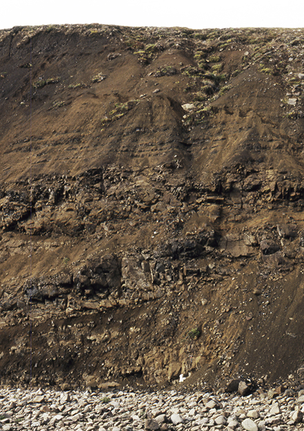
Fig. 62 Heterogeneous volcaniclastic sediments that form the uppermost horizon of the Skalø Member. Height of field of view 14 m; the full thickness of the sediment horizon here is about 15 m. Riverbank c. 5 km north of the end of the Arfertuarsuk inlet.
Eruption sites. None have been found.
Chemistry and chemostratigraphy. The Skalø Member comprises basalts with 4.5–10 wt% MgO, and the average MgO content is 6.5 wt%. TiO2 is in the range 1.1–3.5 wt%, and the average TiO2 content is 2.0 wt%. The magmas were relatively depleted in incompatible trace elements such as Rb, Ba, Th, U, Nb, and light REE, as in basalts of the Tunuarsuk and Nuuit Members. A few flows may be crustally contaminated. Representative analyses are given in the Geochemistry chapter.
The TiO2 stratigraphy shows an increase from low TiO2 contents of around 1.5 wt% at the base to 2.4% upwards in the member (Fig. 42), with the exception of the ‘star basalt’ marker flow (β3.1) in the Skalø profile with values above 3% TiO2, and a very-low-TiO2 basalt with 1.1% TiO2 at the top of the member in the Skalø and Sigguk profiles. The Sigguk profile lacks the high-Ti β3.1 marker flow and, except for the uppermost low-Ti flow, shows a very regular increase in TiO2 with height, indicating that the flows form a coherent sequence and presumably were erupted from the same magma chamber.
Boundaries. The lower boundary of the Skalø Member is placed at the top of the brown-weathering basalts of the Nuuit Member with its red flow tops and tuffs. The boundary is distinct in the north-western and northern areas (Figs 48, 59–61). It is less distinct and not mapped in the faulted and poorly exposed parts of southern Svartenhuk Halvø. Here, much, or all, of the Nuuit Member was included in the Skalø Member area on the map and labelled β2.1, as described previously for the Nuuit Member.
The upper boundary is placed at the base of the brown basalts of the Arfertuarsuk Member of the Naqerloq Formation. In the type section at Sigguk, a poorly exposed volcaniclastic sediment horizon 5–10 m in thickness constitutes the top of the Skalø Member. In the area north of Arfertuarsuk, the top of the member comprises a volcaniclastic sediment horizon of reworked hyaloclastite material c. 20 m in thickness (Fig. 62). In the southern Qooruusaq valley a scree-covered horizon 10–15 m in thickness, presumably of sediment, forms the top of the Skalø Member and is directly overlain by the Arfertuarsuk trachyte flow of the Arfertuarsuk Member of the Naqerloq Formation. The sediment horizon probably represents a break in the volcanic activity and is included in the Svartenhuk Formation.
The upper boundary has only been mapped in westernmost Svartenhuk Halvø in the area between Sigguk, Svartenhavn and Milloorfik. Its extent shown on the map of Larsen & Grocott (1991) is based on long-distance visual correlation and on aerial photographs from the well-exposed boundaries in profile 62 and Siggup Qoorua (7.5 km north of profile 62, Figs 7, 8) and eastwards to the Qooruusaq valley.
The boundary is also present, though unmapped, in the Qooruusaq valley and on Skalø. On Skalø, it is poorly exposed on the top of the plateau, from where a few analysed samples belong to the overlying Arfertuarsuk Member. Fig. 6 shows our present best estimate of the position of the boundary between the Skalø and Arfertuarsuk Members.
Geological age. Paleocene (Thanetian). A radiometric (40Ar/39Ar) age determination of the Skalø Member yielded an age of 57.98 ± 0.59 Ma (Larsen et al. 2016).
Correlation. The Skalø Member is considered to be time-equivalent to the Tuperssuartâta kûa Member on Ubekendt Ejland and to part of the Ifsorisoq Member on Nuussuaq west of the Itilli fault (Fig. 3; Larsen et al. 2016).
Naqerloq Formation
New formation
History. The formation was introduced, but not formalised, by Larsen et al. (2016) and comprises those parts of the original Maligât and Svartenhuk Formations, which had at that time turned out to be of Eocene age. The reduced Maligât and Svartenhuk Formations, of Paleocene age only, are formally revised by Pedersen et al. (2018, Maligât Formation) and in this work (Svartenhuk Formation). The existing names for the members on Nuussuaq and Hareøen (Kanísut Member, Hald 1976) and Ubekendt Ejland (Nûk takisôq Member, Larsen 1977) are unchanged. On Svartenhuk Halvø, Larsen & Larsen (2010) introduced two new informal members, the Sigguk and Arfertuarsuk members, for the Eocene part of the volcanic succession. However, new field and compositional data described below have led to new interpretations, and distinction between these two members cannot be upheld. Consequently, in this work the Naqerloq Formation on Svartenhuk Halvø is not subdivided and the Arfertuarsuk Member is defined to comprise the entire Eocene succession.
Name. After the 7–8 km long Naqerloq valley in westernmost Nuussuaq.
Subdivisions. The Naqerloq Formation contains three members, which are considered to be approximately laterally equivalent:
Arfertuarsuk Member on Svartenhuk Halvø and Skalø.
Nûk takisôq Member on Ubekendt Ejland.
Kanísut Member on Nuussuaq and Hareøen.
Distribution. The Naqerloq Formation is present from Skalø in the north and southwards across western Svartenhuk Halvø, through western Ubekendt Ejland to Nuussuaq west of the Itilli fault and to Hareøen in the south, a N–S distance of around 170 km. The E–W width of the strip of land where the formation is exposed is only 5–15 km. The formation is faulted and variably tilted in all subareas. It is delimited towards the sea or towards faults, and in the north, the eastern delimitation is erosional.
Type area. The type area is the Naqerloq valley in westernmost Nuussuaq. The valley is oriented SE–NW, it is c. 7 km long and opens into the sea in the north-west. Here, a succession of W-dipping lava flows of the Naqerloq Formation (Kanísut Member) is relatively easily accessible (Hald 1976).
Reference sections. On Ubekendt Ejland a reference section in the Nûk takisôq Member is situated along the south-west coast of the island where the succession dips 32°WSW; the base is situated 5.8 km south-east of the point Eqqua (old spelling Erqua), up-section is towards NW, and the top of the member is situated 3.0 km south-east of Eqqua where it is overlain by lava flows of the Erqua Formation (Larsen 1977).
On Svartenhuk Halvø, the Arfertuarsuk profile (36b) and the Sigguk profile (62) are described in the section on the Naqerloq Formation on Svartenhuk Halvø.
Thickness. The Naqerloq Formation is thickest on western Nuussuaq where a succession more than 2000 m thick is preserved (Hald 1976). On western Ubekendt Ejland Larsen (1977) reported a thickness of c. 900 m. On Svartenhuk Halvø 300–400 m of succession are preserved.
Lithology. The Naqerloq Formation is dominated by massive, brown, subaerial basalt lava flows of sheet flow type. The basalts are plagioclase-olivine-clinopyroxene-phyric, microphyric or aphyric. Intermediate and acid tuffs are present at some levels (Hald 1976; Larsen 1977; Larsen et al. 2016), which has significantly contributed to the accuracy of the radiometric age determinations.
Chemistry. The most important characteristic that distinguishes the basalts of the Naqerloq Formation throughout the province from the underlying Paleocene basalts is their chemical composition. The Naqerloq Formation comprises tholeiitic basalts enriched in incompatible elements such as K, P, Sr, Ba, Zr, Nb and light REE. Petrogenetically important element ratios such as P2O5/TiO2, Ba/Sr, Zr/Y, Nb/Y, Nb/Zr, Nb/La, La/Sm and Gd/Lu are all significantly higher in the Naqerloq Formation basalts than in the Paleocene basalts.
Boundaries. The lower boundary is rarely observed because of faulting and poor exposures. On Nuussuaq, the Eocene basalts rest on a thick deposit of volcaniclastic sediments, tuffs and mudstones, which form the Ifsorisok Member of the Svartenhuk Formation (Hald 1976; Larsen et al. 2016). On Svartenhuk Halvø, the Eocene basalts similarly rest on a horizon of volcaniclastic sediments 5–20 m thick, referred to the uppermost Svartenhuk Formation and perhaps a lateral equivalent of the Ifsorisok Member.
The upper boundary is erosional on Skalø, Svartenhuk Halvø and Nuussuaq. On Ubekendt Ejland, basalts of the Nûk takisôq Member are concordantly overlain by alkali basalts of the Erqua Formation (Larsen 1977). On Hareøen, lava flows of the Kanísut Member are overlain by sediments of the Aumarûtigssâ Member (Hald 1976).
Geological age. Eocene, earliest Ypresian. Larsen et al. (2016) reported seven radiometric (40Ar/39Ar) age determinations of basalts from the Naqerloq Formation, ranging from 57.25 ± 0.95 Ma to 54.03 ± 0.33 Ma, generally younging upwards (Fig. 3). Chauvet et al. (2019) reported two basalt ages within the same interval (Fig. 3). Dating of the Arfertuarsuk trachyte flow on Svartenhuk Halvø has been problematic because of stratigraphic misfit, but this flow is now considered to be situated very close to the base of the formation with an age of 56–57 Ma. The flow is considered in detail below.
The Kanísut Member on Nuussuaq is reversely magnetised, and the radiometric ages indicate that the magnetochron is C24r (Riisager et al. 2003).
Correlation. A large part of the offshore volcanic succession penetrated in the Delta-1 drill hole has ages (56–50 Ma) and chemical compositions similar to the Naqerloq Formation (Nelson et al. 2015; see Table 7).
Naqerloq Formation on Svartenhuk Halvø
A large part of the Naqerloq Formation on Svartenhuk Halvø is situated in a strongly faulted area in south-western Svartenhuk Halvø. There is no direct connection to the more northerly part of the formation that is less faulted and situated in nearly flat-lying areas immediately east of Sigguk/Svartenhuk and on Skalø (Fig. 6). The unique Arfertuarsuk trachyte flow near the base of the succession in the southern area is an excellent marker horizon, but, except for a small erosional remnant, it is not present north of Maligissap Kuua. Interpretation of the stratigraphy of the Naqerloq Formation has therefore been difficult. Larsen & Larsen (2010) suggested that the succession in the area north of Maligissap Kuua is older than the trachyte and that the succession in the southern area is younger, with the Arfertuarsuk trachyte flow situated at the base of the younger part, stratigraphically around the middle of the combined succession and thus removed by erosion in the northern areas. This interpretation was based on the relations in the Qooruusaq valley 12–14 km east of Sigguk and c. 20 km north of Arfertuarsuk, where the two parts of the succession almost meet each other. In this down-faulted valley the composite Qooruusaq profile (59–61, Fig. 11) extends from the coast in Milloorfik towards the south-east, uphill and up-section through the NW–SE-striking, SW-dipping lava pile. It ends at poor exposures less than 3 km north-west of, and below, a northern outlier of the trachyte flow (Fig. 6), leaving only 50–75 m stratigraphy below the trachyte unsampled. The sampled flows represent c. 250 m of stratigraphic thickness and all have the enriched geochemical character of the Naqerloq Formation, apparently supporting the stratigraphic model with the trachyte flow in the middle of the combined succession.
Larsen et al. (2016) obtained 40Ar/39Ar ages for a basalt flow on Skalø (sample 251372) of 54.86 ± 0.44 Ma and a basalt flow in the Arfertuarsuk profile (sample 278596) of 55.91 ± 0.60 Ma. The Arfertuarsuk trachyte flow itself has been repeatedly dated with strangely scattered results ranging from Paleocene, 58.4 Ma, for the large anorthoclase phenocrysts to Eocene, 55.3 Ma, for a laser analysis of groundmass alkali feldspar (Table 4). The large anorthoclase phenocrysts are sieve-textured and contain many dark inclusions. An explanation of the results may be that these inclusions contain excess argon that was released uniformly through the successive heating steps; there are fewer inclusions in the groundmass feldspar and the inclusions are avoided in the laser analysis. If this is the case, the laser result is the most reliable and the trachyte flow is of earliest Eocene age. The question remains, however, how close to the base of the Eocene succession is the trachyte flow situated?
| Sample | Material | Plateau age ± 2σ (Ma) | % 39Ar released | Reference |
| 456207 | Anorthoclase | 58.43 ± 0.31 a | 96 | Author, unpublished data |
| 1931.1 | Anorthoclase | 57.51 ± 0.24 a | 80 | Larsen et al. (2016) |
| 1931.1 | Groundmass feldspar | 56.85 ± 0.13 a | 31 | Author, unpublished data |
| S29-E2 | Alkali feldspar | 55.31 ± 1.09 b | Laser analysis | Chauvet et al. (2019) |
| All ages are calculated relative to an age of 28.201 Ma for the Fish Canyon tuff standard. a Incremental step heating result from Oregon State University dating laboratory. b Inverse isochron age. | ||||
The northern outlier of the trachyte in the Qooruusaq valley was briefly visited in 2019 by K. Svennevig (Fig. 63). Below the trachyte, there is an unexposed horizon 10–15 m in thickness, which may represent a sediment horizon although no sediment was seen. Two basalt flows below this horizon and a single basalt flow overlying the trachyte were sampled (profile 67 in Fig. 9). The geochemical analyses showed that whereas the flow above the trachyte has the enriched character of the Naqerloq Formation, the two flows below the trachyte have not; they have the typical character of the Paleocene basalts and are considered to belong to the Skalø Member of the Svartenhuk Formation. The trachyte flow is therefore the oldest Eocene lava flow at this locality. The apparent stratigraphic continuity to the Eocene flow succession in profile 59–61 farther north in the Qooruusaq valley is therefore lost. We must assume that an unexposed fault crosses the valley between the trachyte outlier and the Qooruusaq sample profile (Fig. 11), with a relative downthrow of c. 300 m of the succession to the north (Fig. 6).
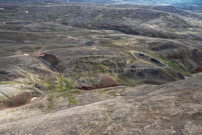
Fig. 63 The northern outlier of the Arfertuarsuk trachyte in the uppermost reaches of the Qooruusaq valley (Fig. 9, profile 67). The exposed trachyte is traced with a solid white line; it is black due to lichen coverage. The presumed total extent of the trachyte is indicated with a dashed white line. See text for descriptions. Note the flat country with almost no exposures in the background; this is part of the low-lying area in central western Svartenhuk Halvø seen in the digital elevation model (Fig. 9), where mapping was very difficult and some geological boundaries are only tentative or not placed at all. Photo: Kristian Svennevig.
In the area north of the Arfertuarsuk inlet where the trachyte and the overlying lava flows have been mapped (Larsen & Grocott 1991), the trachyte flow is underlain by two or three lava flows with hyaloclastite and hyalotuffs resting on c. 20 m of reworked volcaniclastic sediment. This sediment has been referred to the uppermost Skalø Member of the Svartenhuk Formation. The flows below the trachyte and above the sediments have the chemical character of the Naqerloq Formation but have significantly lower TiO2 (1.8–2.06 wt%) than the flows above the trachyte (>2.4 wt% TiO2; see Fig. 42 and the Geochemistry chapter). Flows with similar low-Ti compositions occur at the base of the Naqerloq Formation at Sigguk (profile 62) and in the northern Qooruusaq valley (profile 59–61). We therefore consider it most probable that the trachyte flow did not reach the northern areas, and that the top of the low-Ti flows marks the level corresponding to the trachyte. This means that the three profiles, Sigguk (62), Arfertuarsuk (36b) and Qooruusaq (59–61), are laterally equivalent. Indeed, their basalts are compositionally very similar although no single flows are correlatable and the TiO2 developments up-section are different (Fig. 42).
In view of the probable lateral equivalence of the exposed parts of the Naqerloq Formation, we prefer to define them within the framework of one member only. We therefore extend the Arfertuarsuk Member sensu Larsen & Larsen (2010) to cover the entire Eocene succession on Svartenhuk Halvø and Skalø. The Sigguk member sensu Larsen & Larsen (2010) is discontinued.
Arfertuarsuk Member
New member
History. On the geological map 71 V.1 Nord Svartenhuk (Larsen & Grocott 1991), the Arfertuarsuk Member is shown in the area between Sigguk and Qooruusaq as the unit β3.3, and in the area between Maligissap Kuua and the Arfertuarsuk inlet as the unit β4. The trachyte flow is mapped as a separate, unlabelled unit.
Name. After the Arfertuarsuk inlet on south-western Svartenhuk Halvø.
Distribution. The Arfertuarsuk Member is present in the western part of Svartenhuk Halvø from Skalø in the north to the bottom of the Arfertuarsuk inlet in the south. The member has been mapped in the strongly faulted and tilted areas north-west of Arfertuarsuk and traced on aerial photographs on the Sigguk peninsula west of the Qooruusaq valley (Larsen & Grocott 1991). However, the formation is also present and sampled on Skalø and in the eastern Qooruusaq valley where the lower boundary was not sufficiently established to be shown on the map. Thus, the western part of the Skalø Member area (β3 on the map) includes many more areas with lavas of the Arfertuarsuk Member than shown. Our present best estimate of the distribution of the Arfertuarsuk Member is shown in Fig. 6.
Type section. Arfertuarsuk (profile 36b) north of the bottom of the Arfertuarsuk inlet. The profile runs across a ridge and follows the south-west side of a WNW–ESE-trending fault, changing midway to a WSW direction (Fig. 9; coordinates in Appendix 1). The lava succession is strongly tilted with dips around 20°SW and locally more, and the profile shown in Fig. 11 is composed of several parts. The profile contains a thick, mappable trachyte flow, the Arfertuarsuk trachyte, near the base of the Arfertuarsuk Member.
Reference section. Sigguk (profile 62). The lava pile here is unfaulted and flat-lying with a low dip to the east (Figs 11, 64). Lava flows of the Arfertuarsuk Member here concordantly overlie lava flows and a sediment horizon of the Skalø Member and extend from c. 360 m a.s.l. to the geodetic point at 643 m a.s.l. where a distinctly porphyritic flow occurs at the top of the profile. No trachyte flow is present.
Thickness. The preserved thickness of the Arfertuarsuk Member is c. 300 m in the Sigguk area and more than 350 m in the area north of Arfertuarsuk.
Lithology. Basalts of the Arfertuarsuk Member are dominantly brownish sheet flows or compound pahoehoe flows, which are plagioclase ± olivine ± clinopyroxene glomerophyric or aphyric. A few flows with large (>1 cm) platy plagioclase phenocrysts are present at the top of the Sigguk profile. Sheet flows dominate in the Arfertuarsuk profile. Flows of the member are mostly glomerophyric, and one flow has box-shaped plagioclase phenocrysts several centimetres in size with reaction rims. Two olivine-plagioclase-phyric basalts are present, one of which is a compound flow. One lava flow with relatively high MgO (11 wt%) has ankaramitic affinity with only olivine and clinopyroxene phenocrysts. Aphyric basalts dominate the upper part of the profile. Several well-exposed tuff beds are present. A dark doleritic basalt flow is present near the top of the succession.
In the area north of the Arfertuarsuk inlet, a trachyte flow up to 40 m in thickness is present near the base of the Arfertuarsuk Member (Fig. 6). It is the only one of its kind in the region and is important for the stratigraphy of the member, as discussed in the previous section. It was first described and analysed by Nieland (1931), who showed it to be an anorthoclase trachyte. The flow is present for 12 km along the SE–NW strike direction (Larsen & Grocott 1991) and thins towards the north. A small erosional remnant is present 7 km farther north in another fault block in the southernmost Qooruusaq valley (Fig. 6), but except for this, the trachyte flow is missing north of Maligissap Kuua. The flow is well exposed on the coast at the northern end of the Arfertuarsuk inlet. It is composed of several units, of which the basal unit is a more or less welded and devitrified vitrophyre that may be classified as a rheomorphic ignimbrite (Jørgensen 1982). The major part of the trachyte is a more normal, massive flow (Fig. 65); it is rich in anorthoclase crystals up to several centimetres in size; these large phenocrysts are dotted with dark inclusions in a sieve-texture. Microphenocrysts of pale brown clinopyroxene and magnetite are present, and the medium-grained groundmass is very rich in alkali feldspar. The flow contains up to cobble-sized xenoliths of intermediate igneous rock types (sample 278668.1) and syenite (sample 278669.2; Fig. 66). The trachyte outlier in Qooruusoq contains several 2–6 cm-sized, irregular, fine-grained, dark grey inclusions of extremely evolved composition (sample 568601.2 in Fig. 67; see the Geochemistry chapter). A fine-grained, dark grey vein cutting the trachyte (Fig. 68) likely consists of similar material.
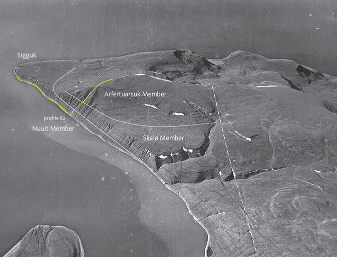
Fig. 64 Lava flows of the Paleocene Nuuit and Skalø Members of the Svartenhuk Formation conformably overlain by lava flows of the Eocene Arfertuarsuk Member of the Naqerloq Formation. Profile 62 is indicated with a yellow line. Western Svartenhuk Halvø with the point Sigguk (Svartenhuk) looking NW. Length of the coast from the foreground to Sigguk is 10 km. Dash-dot lines are faults. Geodetic Institute oblique aerial photograph 526GN/6272.
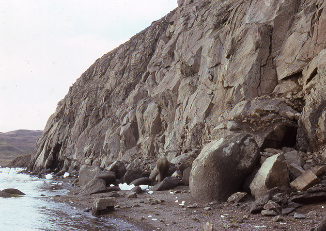
Fig. 65 The Arfertuarsuk trachyte flow exposed on the beach, east side of the northern end of the Arfertuarsuk inlet. Height of section c. 15 m. Photo: Karl Aage Jørgensen.
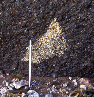
Fig. 66 Feldspar-rich xenolith, probably cognate, of syenite in the Arfertuarsuk trachyte flow. Length of steel rod 16 cm. East side of the northern end of the Arfertuarsuk inlet. Photo: Karl Aage Jørgensen.
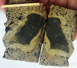
Fig. 67 Fine-grained, dark grey inclusion in trachyte from the outlier in Qooruusaq, cut into two. The inclusion is surrounded by a light-coloured rim almost exclusively of coarse alkali feldspar; contrary to intuition the dark central part consists of about as much feldspar as the rim; the major difference is the grain size. The analysis (278669.2) represents the dark part. Length of match 4.7 cm. Photo: Erik Vest Sørensen.
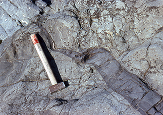
Fig. 68 Fine-grained, dark grey vein cutting the Arfertuarsuk trachyte flow. East side of the northern end of the Arfertuarsuk inlet. Length of hammer 45 cm. Photo: Karl Aage Jørgensen.
Eruption sites. None have been found.
Chemistry and chemostratigraphy. The Arfertuarsuk Member comprises tholeiitic basalts with 3.8–8.6 wt% MgO and an average of 5.8 wt% MgO. TiO2 is in the range 1.8–4.0 wt%, and the average TiO2 content is 3.0 wt%. K2O and P2O5 contents are high, with on average 0.80 wt% K2O and 0.39 wt% P2O5. The Arfertuarsuk Member basalts are also enriched in other incompatible elements such as Sr, Ba, Zr, Nb and light REE, and element ratios such as P2O5/TiO2, Ba/Sr, Zr/Y, Nb/Y, Nb/Zr, Nb/La, La/Sm and Gd/Lu are significantly increased relative to basalts of the Svartenhuk Formation. Representative analyses are given in the Geochemistry chapter.
The trachyte flow contains on average 65.7 wt% SiO2, 0.83 wt% TiO2, 0.24 wt% MgO, 16.4 wt% Al2O3, 6.1 wt% Na2O and 5.2 wt% K2O.
A group of less evolved basalts with low TiO2 (around 2 wt%) and P2O5 (around 0.25 wt%) and with the same enriched geochemical character as the more evolved basalts of the member is clearly distinguished in the chemistry diagrams (see the Geochemistry chapter). As explained in the earlier section on the Naqerloq Formation on Svartenhuk Halvø, these basalts occur below the trachyte flow in the Arfertuarsuk area and are used to define an interpreted trachyte level in the northern areas (Sigguk and Qooruusaq profiles).
According to our interpretation, the analysed sample profiles through the Eocene basalts from the northern and the southern areas, mainly the Sigguk, Qooruusaq and Arfertuarsuk profiles (62, 61, 36b), are nearly laterally equivalent (Figs 11, 42). They are geochemically similar but do not show any obvious mutual correlation.
Boundaries. The lower boundary is depositional and is placed at the base of a succession of brown lava flows of geochemically enriched basalts and above a volcaniclastic sediment horizon 5–20 m in thickness included in the Skalø Member. The upper boundary is erosional.
Geological age. Eocene (earliest Ypresian), perhaps reaching back into the uppermost Paleocene. Two radiometric (40Ar/39Ar) age determinations of basalts yielded ages of 55.91 ± 0.60 Ma and 54.86 ± 0.44 Ma (Larsen et al. 2016), and one of the Arfertuarsuk trachyte flow yielded an age of 55.31 ± 1.09 Ma (Chauvet et al. 2019). See Table 4 and the corresponding text for a discussion of the age of the trachyte.
Correlation. The Arfertuarsuk Member was erupted in a similar time interval (57–54 Ma) and has the same geochemical character as the Nûk takisôq Member on Ubekendt Ejland and the Kanísut Member on Nuussuaq and Hareøen, and is thus in a general way correlatable with these.
Intrusions
Svartenhuk Halvø is cut by numerous dykes. The dyke distribution map in Fig. 69 from Larsen & Pulvertaft (2000) shows the distribution and directions of dykes as identified on aerial photographs. The map gives an overall impression of dyke patterns, but as stressed by these authors, dykes are much easier to locate in the areas with crumbling picrites of the Vaigat Formation than in the areas with robust basalt flows of the Svartenhuk and Naqerloq Formations. The relative sparsity of dykes located in the basalt areas in central and western Svartenhuk Halvø may therefore not be real. The dykes extend north to Skalø and southern Innerit and also cut the basement and volcanic rocks north-east of the Cretaceous boundary fault system, but they quickly die out to the north and east where reconnaissance work revealed very few dykes. The dyke distribution pattern, including the scarcity of Tertiary dykes in the northern and eastern areas, confirms the impression gained from the hyaloclastites and lava flows that eruption sites were centred in the basinal areas, from where the lavas flowed to the north and east over distances of up to 80 km for the most voluminous flows.
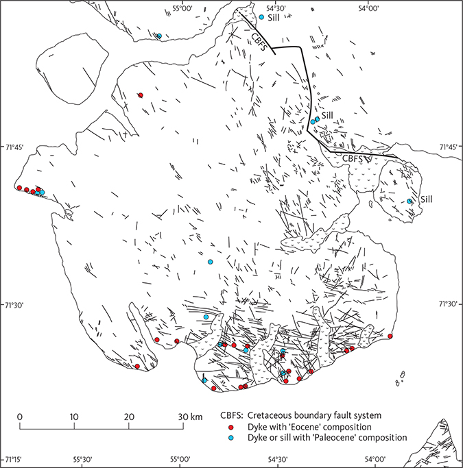
Fig. 69 Distribution and directions of dykes on Svartenhuk Halvø as identified on aerial photographs, from Larsen & Pulvertaft (2000, fig. 4). The relative sparsity of dykes in the basalt areas in central and western Svartenhuk Halvø may not be real, see text for explanation. We have added the locations of analysed basalt dykes and sills of two different compositional groups that are supposed to represent two age groups, as indicated in the legend. Analytical data from this study and Agranier et al. (2019).
Larsen & Pulvertaft (2000) presented a detailed structural analysis of the dyke orientations and concluded that several dyke generations are present. The dykes comprise picrites and feldspar-phyric and aphyric basalts petrographically similar to the lava flows, and their chemical compositions (see the Geochemistry chapter) comply with the assumption of Larsen & Pulvertaft (2000) that many dykes are feeders to the lava flows. Accordingly, the dykes most commonly have dips perpendicular to the lava flows, which they cut (e.g. Figs 15, 16, 37), and the fault zones are generally not intruded by dykes. Feeder dykes and eruption sites for all three members of the Vaigat Formation have been identified in the field and confirmed chemically. In contrast, eruption sites for the Svartenhuk Formation have rarely been observed, and none are known for the Naqerloq Formation.
Picrite dykes and strongly contaminated dykes similar to the Kakilisaat Member are only found in the areas of the Vaigat Formation, whereas basaltic dykes are found all over Svartenhuk Halvø.
As described in the Geochemistry chapter, the basaltic dykes form two groups with compositions corresponding to those of respectively the Svartenhuk and Naqerloq Formations. This enables us to distinguish between basalt dykes of presumed Paleocene age (Svartenhuk Formation) and of presumed Eocene age (Naqerloq Formation) and thus to confirm the presence of at least two distinct dyke generations. Our analysed dykes with Naqerloq Formation chemistry are all situated in the Svartenhuk Formation in western Svartenhuk Halvø, but Agranier et al. (2019) published analyses of samples with Naqerloq Formation chemistry from areas in the Vaigat Formation along the entire south coast of Svartenhuk Halvø from Tartuusaq to Maniiseqqut (Fig. 69). This suggests that the Eocene lava succession originally extended much farther eastwards on the continent than the present outcrops, as also found for Nuussuaq and Disko (Larsen et al. 2016; Pedersen et al. 2018). Unfortunately, dyke compositions are unknown in large areas, but it should be possible to map the true distribution of both the Eocene and the Paleocene dykes by analysing a larger number of dyke samples distributed over the Svartenhuk Halvø. Additionally, even younger dykes may be identified if they are compostionally different from the older lavas and dykes.
The Cretaceous boundary fault system has apparently facilitated the intrusion of magmas, as seen from a number of large basalt sills intruded close to the fault at Simiutaq, along the Siuteqqut Kuuat valley, near Firefjeld and on Itsaku (Fig. 6). These sills are compositionally identical to the Svartenhuk Formation and we therefore consider that they are also of late Paleocene age.
A small intrusion of magnesian basalt is exposed at sea level on the south coast of Svartenhuk Halvø c. 3.5 km south of Tasiusap Imaa (Fig. 70). It has a cupola-like structure and is c. 20 m wide and 25 m high. It intrudes lava flows of the Tunuarsuk Member and has a similar chemical composition (10.8 wt% MgO, sample 164863). It is chilled towards the lavas in a c. 5 m wide zone, which has a distinct layering with decimetre-thick, alternating light and dark layers parallel to the contact.
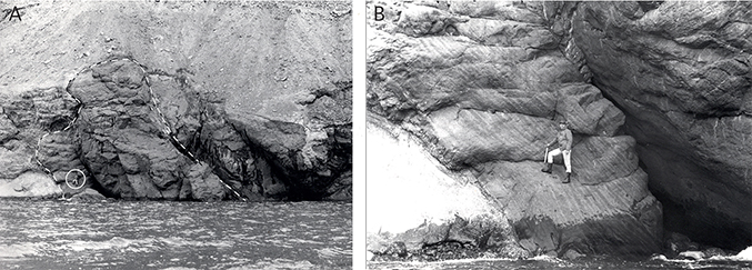
Fig. 70 An intrusion of magnesian basalt into lava flows of the Tunuarsuk Member. A: The entire exposure, showing the cupola-like shape. B: The chilled marginal zone with contact-parallel mineral layering. The person (encircled in A) is standing in the same place in both photos. South coast of Svartenhuk Halvø c. 3.5 km south of Tasiusap Imaa; the intrusion is shown with a size of 1 × 0.5 mm on the geological map (Larsen 1983).
A few alkaline dykes (alkali basalt and camptonite) are found on the south coast of Svartenhuk Halvø (Larsen 1983; L.M. Larsen 2006). The ages of these dykes are not known and they could be very young. The youngest dykes identified in the region are c. 34 Ma old camptonite and monchiquite dykes from Ubekendt Ejland (Larsen 1981c, 1982; Clarke et al. 1983; Storey et al. 1998).
Geochemistry and petrology of the volcanic rocks
Identification of crustal contamination and geochemical enrichment
The volcanic rocks in the Nuussuaq Basin consist predominantly of tholeiitic basalts and picrites such as those generated by melting of common asthenospheric mantle (e.g. McKenzie & Bickle 1988). However, as mentioned frequently in this study and defined in the Nomenclature section, there are also rocks, which are considered to be contaminated with continental crustal material, as well as geochemically enriched rocks with elevated contents of a number of incompatible elements. Identification of the two rock groups is best achieved using trace-element ratios. A diagram showing Th/Nb vs. Nb/Zr is particularly useful because the crustal-contamination and enrichment vectors are perpendicular to each other (Fig. 71). In this figure crustally contaminated samples generally have Th/Nb >0.12, whereas most enriched samples have Nb/Zr >0.10. Small degrees of crustal contamination and enrichment are difficult to detect.
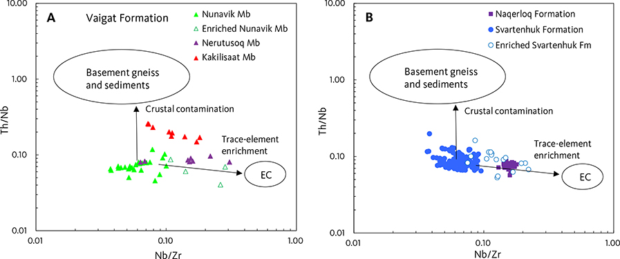
Fig. 71 Th/Nb vs. Nb/Zr diagram showing discrimination between crustally contaminated and geochemically enriched samples. A: Vaigat Formation. B: Svartenhuk and Naqerloq Formations. The crustal contamination vector points upwards because basement gneiss and sediments have high Th/Nb, whereas the enrichment vector points towards enriched components (EC) with high Nb/Zr. Data for basement gneiss and sediments from Larsen & Pedersen (2009). The EC field represents a number of presumed local enriched components.
In the Vaigat Formation (Fig. 71A) the Kakilisaat Member is clearly crustally contaminated, and the extension of the plot field towards the enriched components indicates that some samples are also enriched. The Nerutusoq Member is enriched but not crustally contaminated. Fig. 71B shows that the Svartenhuk Formation basalts analysed for trace elements are generally uncontaminated although a number of samples have Th/Nb c. 0.12 and may perhaps be slightly crustally contaminated. There is a trail of enriched samples towards the enriched component field; one sample (262713) has high Th/Nb (0.16) and low Nb/Zr (0.09) and is both contaminated and enriched. The enriched character of the Naqerloq Formation is clearly seen.
Vaigat Formation
The volcanic rocks of the Vaigat Formation on Svartenhuk Halvø comprise tholeiitic picrites and subordinate basalts. Major element variation diagrams for the Vaigat Formation are shown in Fig. 72, trace- element variation diagrams in Figs 73 and 74, and REE and multi-element plots in Fig. 75. These figures are designed to be comparable with the similar geochemistry diagrams for the Vaigat Formation on Disko and Nuussuaq in Pedersen et al. (2017). Representative chemical analyses are shown in Table 5.
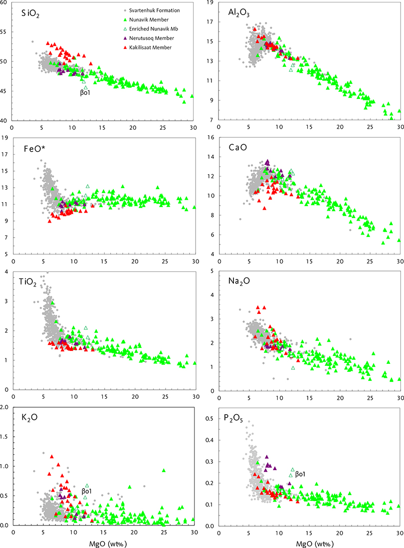
Fig. 72 Major-element variation diagrams for rocks of the Vaigat Formation. Note the MgO-rich character of the Nunavik Member, the high CaO and P2O5 in the Nerutusoq Member and the high SiO2 and low FeO* and CaO in the crustally contaminated Kakilisaat Member. βo1 is a marker horizon in the Nunavik Member. Data points for the Svartenhuk Formation are shown in grey for comparison. Data in wt% oxides.
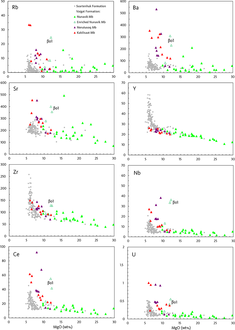
Fig. 73 Incompatible trace-element variation diagrams for rocks of the Vaigat Formation. The Nunavik Member has low concentrations of these elements, but scattered lavas are enriched in Sr, Nb, Ba and Ce, akin to the Nerutusoq Member. The marker horizon βo1 has a unique, very enriched composition. The crustally contaminated Kakilisaat Member has unusually high Nb, suggesting that some of these magmas are enriched in addition to being contaminated. Data points for the Svartenhuk Formation are shown in grey for comparison. Vertical axes in ppm.
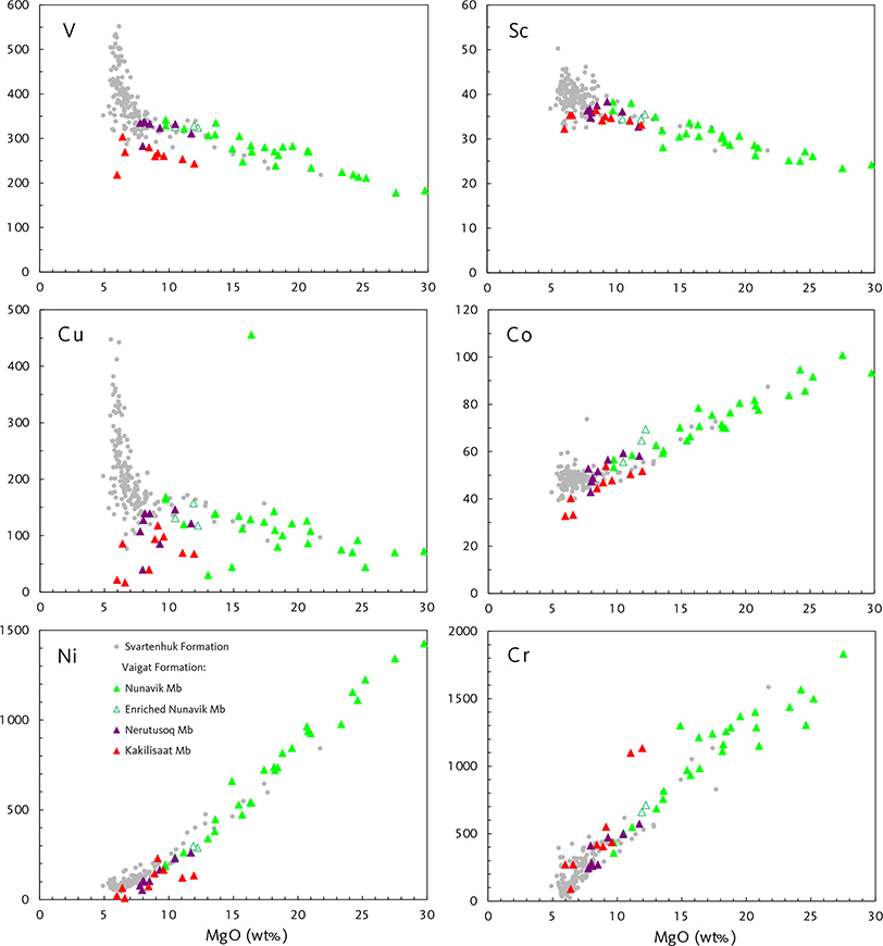
Fig. 74 Transition-element variation diagrams for rocks of the Vaigat Formation. Note the apparent loss of V, Cu, Co and Ni in the Kakilisaat Member. Data points for the Svartenhuk Formation are shown in grey for comparison. Vertical axes in ppm.
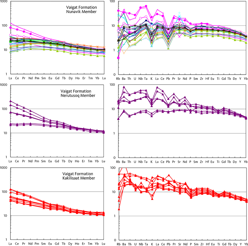
Fig. 75 REE and multi-element diagrams for representative rocks of the Vaigat Formation. Different colours of curves in the Nunavik Member diagrams are intended to aid the distinction of the individual samples. The magenta samples in the Nunavik Member are incompatible-element-enriched; the two with the highest values are from the βo1 marker horizon. Left diagrams: chondrite normalised. Right diagrams: primitive mantle normalised. Normalisation factors from McDonough & Sun (1995).
| 181015 | Fine-grained olivine-phyric magnesian basalt, slightly crustally contaminated. Thick, compound pahoehoe flow, uppermost flow in the Kakilisaat Member. Profile 4, Kakilisaat, south-east Svartenhuk Halvø. |
| 181019 | Fine-grained olivine-phyric magnesian basalt, crustally contaminated. Compound pahoehoe flow beneath the uppermost hyaloclastite horizon in the Kakilisaat Member. Profile 4, Kakilisaat, south-east Svartenhuk Halvø. |
| 181022 | Fine-grained aphyric silicic basalt, crustally contaminated. Pillow lava horizon on top of 75 m foreset-bedded hyaloclastite low in the Kakilisaat Member. Profile 4, Kakilisaat, south-east Svartenhuk Halvø. |
| 181037 | Fine-grained aphyric silicic basalt, crustally contaminated. Lava flow in the upper Kakilisaat Member, western corner of the mouth of Ulissat Qooruat, south-east coast of Svartenhuk Halvø. Located on Fig. 17. |
| 181073 | Fine-grained aphyric silicic basalt, crustally contaminated. Kakilisaat Member lava flow low in profile 13, Saviit South, southern Svartenhuk Halvø. |
| 181075 | Plagioclase-olivine-phyric basaltic andesite, crustally contaminated and enriched in incompatible trace elements (Th, U, Nb, REE). Kakilisaat Member lava flow in profile 13, Saviit South, southern Svartenhuk Halvø. |
| 263818 | Aphyric magnesian basalt. Brown hyaloclastite, Nerutusoq Member in profile 48b, Nerutusoq valley at 360 m altitude, northern Svartenhuk Halvø. |
| 181077 | Aphyric basalt distinctly enriched in incompatible trace elements (Ba, Th, U, Nb, REE). lava flow, Nerutusoq Member in Profile 13, Saviit South, southern Svartenhuk Halvø. |
| 263822 | Aphyric basalt enriched in incompatible trace elements (Ba, Th, U, Nb, REE). Brown pillow breccia, Nerutusoq Member in profile 48b, Nerutusoq valley, northern Svartenhuk Halvø. |
| 263823 | Aphyric basalt enriched in incompatible trace elements (Ba, Th, U, Nb, REE). Brown lava flow, Nerutusoq Member in profile 48b, Nerutusoq valley, northern Svartenhuk Halvø. |
| 181013 | Fine-grained aphyric basalt distinctly enriched in incompatible trace elements (Ba, Th, U, Nb, REE). Pahoehoe lava flow, Nerutusoq Member in profile 4, Kakilisaat, south-east Svartenhuk Halvø. |
| 263821 | Aphyric basalt enriched in incompatible trace elements (Ba, Th, U, Nb, REE). Black hyaloclastite, Nerutusoq Member in profile 48b, Nerutusoq valley, northern Svartenhuk Halvø. |
| 181066 | Olivine-rich picrite. Pahoehoe flow lobe in grey compound lava flow, lower Nunavik Member in profile 24, Peak 1120 m, southern Svartenhuk Halvø. |
| 181067 | Olivine-rich picrite. Pahoehoe flow lobe in grey compound lava flow, lower Nunavik Member in profile 24, Peak 1120 m, southern Svartenhuk Halvø. |
| 251515 | Olivine-rich picrite. Pahoehoe flow lobe in grey compound lava flow, upper Nunavik Member in profile 9, Peak 1078 m, eastern Svartenhuk Halvø. |
| 251525 | Olivine-microphyric picrite. Pahoehoe flow lobe in grey compound lava flow, middle Nunavik Member in profile 9, Peak 1078 m, eastern Svartenhuk Halvø. |
| 251529 | Medium-grained picrite. Pahoehoe flow lobe in grey compound lava flow, lower Nunavik Member in profile 9, Peak 1078 m, eastern Svartenhuk Halvø. |
| 278353 | Picrite. Pahoehoe flow lobe in greenish grey, compound lava flow, upper Nunavik Member in profile 44c, Kuugaartorfik, northern Svartenhuk Halvø. |
| 181085 | Olivine-poor picrite. Sheet flow 25 m in thickness, middle Nunavik Member in profile 14, Saviit North, southern Svartenhuk Halvø. |
| 251589 | Medium-grained picrite. Pahoehoe flow lobe in grey compound lava flow, upper Nunavik Member in profile 30, Ivissukkat Itinnerat, east-central Svartenhuk Halvø. |
| 278354 | Mg-poor picrite. Pahoehoe flow lobe in crumbling compound lava flow, upper Nunavik Member in profile 44c, Kuugaartorfik, northern Svartenhuk Halvø. |
| 251527 | Olivine-microphyric magnesian basalt distinctly enriched in incompatible trace elements (Ba, Th, U, Nb, Zr, Sr, REE). Pahoehoe flow lobe at base of dark marker horizon βo1. Compound lava flow, middle Nunavik Member in profile 9, Peak 1078 m, eastern Svartenhuk Halvø. |
| 251588 | Medium-grained magnesian basalt. Pahoehoe flow lobe in grey compound lava flow, upper Nunavik Member in profile 30, Ivissukkat Itinnerat, east-central Svartenhuk Halvø. |
| 181056 | Olivine-phyric basalt. Lava flow with pseudopillow structure, upper Nunavik Member in profile 24, Peak 1120 m, southern Svartenhuk Halvø. |
Nunavik Member
The Nunavik Member is described first because it constitutes the bulk and ‘normal’ part of the Vaigat Formation in the area. The two other members are considered to be derived from magmas similar to those of the Nunavik Member with some additions of material from the crust and upper mantle.
The Nunavik Member is dominated by picrites. The total MgO range is 6.4–29.8 wt% MgO, and the average MgO content of 130 analyses is 17.5 wt% MgO, which is probably not far from the parental magma composition (Larsen & Pedersen 2000, 2009; Herzberg & O’Hara 1998, 2002; Herzberg et al. 2007). The well-defined trends, particularly in the major-element diagrams (Fig. 72), are caused by olivine fractionation and accumulation, as already noted by Clarke (1970). When the fractionating magma reached 7–8 wt% MgO, plagioclase started to crystallise, which removed CaO and Al2O3 from the magma. Figure 72 shows that most of the magmas of the Nunavik Member did not reach the stage of plagioclase fractionation, with the βo2 basalt marker flow near the top of the member as an exception (6.4 wt% MgO, 13.6 wt% Al2O3, 10.6 wt% CaO and 2.9 wt% TiO2). A couple of samples with low CaO also have high SiO2 and are crustally contaminated. Relatively scattered K2O contents are due to secondary alteration.
With some exceptions, the rocks have a relatively depleted geochemical character, meaning that they have low contents of incompatible elements. The incompatible trace elements (Figs 71, 73, 75) show a general increase with increasing fractionation. A few scattered flows are enriched in some elements (Rb, Ba, Sr, Zr, Nb, REE and U); these flows are not distinguishable by their major elements but are clearly distinguished in the trace-element diagrams (Figs 71, 73, 75). The dark marker horizon βo1 in the Nunavik Member has a Nb/Zr ratio of 0.26–0.28 and is one of the most enriched flows of all (Fig. 71); the two samples analysed from βo1 are situated c. 15 km apart.
The only trace elements that are fractionated out of the picrite magmas are Ni and Co in olivine and Cr in chromite (Fig. 74).
The low contents of incompatible elements in the common rocks of the Nunavik Member are reflected in the REE and multi-element patterns in Fig. 75. Most REE patterns for the Nunavik Member have chondrite-normalised (with subscript N) LaN <SmN so that the La–Sm limbs have positive slopes, giving the patterns an overall humpback-like shape. Likewise, the multi-element patterns have Rb–La limbs with positive slopes. However, some samples have LaN ≥SmN and near-horizontal to negative slopes of the La–Sm and Rb–La limbs. The deep troughs at K and Pb are characteristic of asthenosphere-derived magmas from the North Atlantic Tertiary Igneous Province (e.g. Saunders et al. 1997).
The distribution of LaN/SmN ratios of the Nunavik Member, with most samples having values less than 1 and some samples having values above 1 (see also Fig. 83), is similar to that found in the Ordlingassoq Member of the Vaigat Formation on Nuussuaq and Disko (Larsen & Pedersen 2009; Pedersen et al. 2017; see also contour line for the Ordlingassoq Member in Fig. 83). In contrast, the earlier members of the Vaigat Formation (the Anaanaa and Naujánguit Members) have LaN/SmN consistently less than 1 and are thus somewhat more geochemically depleted than the Ordlingassoq and Nunavik Members. This is a key feature in the correlation of the last-named members.
Nerutusoq Member
The Nerutusoq Member consists of basalts with 8–12 wt% MgO, normal SiO2 contents of 48–49 wt% and relatively high contents of CaO (12–13.6 wt%; Fig. 72). The rocks have distinctly high P2O5 (0.20–0.32 wt%) and are also enriched in incompatible elements such as Ba, Th, U, Nb, light REE, Pb and Sr relative to the Nunavik Member rocks (Figs 72, 73, 75). The patterns of enrichment in the Nerutusoq Member lack the high Nb–Ta peak and the deep Pb trough seen in the enriched rocks of the Nunavik Member, suggesting that the sources of the enrichment for the two members are different. Our analysed samples from the Nerutusoq Member are not crustally contaminated; however, Agranier et al. (2019) reported contaminated, enriched samples presumably from this member (their Site 40). It is thus possible that small degrees of crustal contamination have contributed to the differences in enrichment pattern between the two members. The Nerutusoq Member shows notable similarities to some enriched rock units on Nuussuaq and Disko (Larsen et al. 2003; Larsen & Pedersen 2009; Pedersen et al. 2017).
Kakilisaat Member
The Kakilisaat Member consists of silicic basalts, basaltic andesites and a few Si-enriched picrites; MgO is in the range 6–13 wt%. The rocks have elevated SiO2, K2O, Rb, Ba, Th, U, light REE and Pb, and low MgO, CaO, TiO2, FeO* (total iron as FeO), V, Cu and Ni relative to the rocks of the Nunavik Member (Figs 72–75). These features are typical for rocks that are contaminated with continental crustal material, either crystalline basement or clastic sediments (e.g. Larsen & Pedersen 2009; Pedersen et al. 2018). The occurrence of sediment xenoliths in the volcanic rocks suggests that the contamination took place in high-level magma chambers in the crust, presumably within the sediments of the Nuussuaq Basin. The low contents of V, Cu, Ni and Co (Fig. 74) indicate a possibility that the contamination process may have resulted in the formation at depth of mineral deposits with these elements. The relatively high Nb contents (Fig. 73) suggest that the original magmas had a somewhat enriched character akin to that of the Nerutusoq Member. The rocks of the Kakilisaat Member show compositional similarities to the crustally contaminated basalts of the Tunoqqu and Kûgánguaq Members on Nuussuaq and Disko (Larsen & Pedersen 2009; Pedersen et al. 2017).
Svartenhuk Formation
The volcanic rocks of the Svartenhuk Formation comprise tholeiitic basalts, subordinate picrites and a few basaltic andesites. They have a total range of 3.4–21.7 wt% MgO with an average of 7.2 wt% MgO (620 analyses). A few basalts are crustally contaminated and some scattered basalts are geochemically enriched. Major element variation diagrams for the Svartenhuk Formation are shown in Fig. 76, trace-element variation diagrams in Figs 77 and 78, and REE and multi-element diagrams in Fig. 79. Note that Figs 76–78 use the mg-number as abscissa and not the MgO content as in the plots of the Vaigat Formation; this is because the major part of the basalts have a limited variation in MgO content (5–9 wt% MgO), which does not produce a sufficiently large spread on the abscissa. The figures are designed to be comparable with the similar geochemistry diagrams for the Maligât Formation in Pedersen et al. (2018). Representative chemical analyses are shown in Table 6.
| 181120 | Picrite with platy and equant olivine phenocrysts. Single olivin-rich lava flow within a succession of plagioclase glomerophyric and aphyric basalts. Tunuarsuk Member, Qinnivik peninsula 1 km WSW of point 631 m, south-western Svartenhuk Halvø, indicated on the geological map (Larsen 1983) as βo. |
| 278559 | Aphyric picrite distinctly enriched in incompatible trace elements (Ba, Th, U, Nb, Sr, REE). Pahoehoe flow lobe in compound flow c. 10 m thick and with 1 m dark red scoriaceous top zone. Tunuarsuk Member in profile 50, Umiiarfik South, northern Svartenhuk Halvø. |
| 251317 | Medium-grained picrite. Pahoehoe flow lobe, part of dark greenish compound flow, uppermost Tunuarsuk Member in profile 42, Marrarnaq, northern Qeqertaq peninsula 11 km south-east of the settlement Kangersuatsiaq (Prøven). |
| 251281 | Olivine-phyric magnesian basalt. Massive lava flow 50 m thick and with 10 m scoriaceous top zone, uppermost flow in Tunuarsuk Member in profile 38, Qaqqap Qaa, east coast of the Innerit peninsula. |
| 262803 | Plagioclase-phyric magnesian basalt. Massive lava flow c. 40 m thick, middle Tunuarsuk Member in profile 64, Paannivik, southern Innerit. |
| 251295 | Plagioclase-phyric basalt. Massive lava flow c. 40 m thick, middle Tunuarsuk Member in profile 38, Qaqqap Qaa, east coast of the Innerit peninsula. |
| 278343 | Aphyric basalt. Massive lava flow c. 20 m thick, between hyaloclastite horizons, lower Tunuarsuk Member in profile 44c, Kuugaartorfik, northern Svartenhuk Halvø. |
| 251333 | Weakly plagioclase-phyric basalt enriched in incompatible trace elements (Ba, Th, U, Nb, Sr, REE). Massive lava flow c. 60 m thick, middle Tunuarsuk Member in profile 37, Nuup Qaava, northern side of the Innerit inlet on the west side of the Innerit peninsula. |
| 262815 | Aphyric basalt slightly enriched in incompatible trace elements (Ba, Th, U, Nb, Sr, REE, Ti). Massive lava flow c. 25 m thick, middle Tunuarsuk Member in profile 64, Paannivik, southern Innerit. |
| 262793 | Plagioclase-phyric Mg-poor basalt. Lava flow 5-10 m thick, middle Tunuarsuk Member in profile 64, Paannivik, southern Innerit. |
| 566511 | Aphyric basalt, Nuuit Member. Highest lava flow in profile 65, Salliaruseq, north-east of Svartenhuk Halvø. |
| 566505 | Plagioclase microphyric basalt lava flow. Reconnaissance sample, nunatak in side valley at the upper reaches of Umiammakku Sermia (glacier), GPS coordinates 72°4.3′N, 51°58.8′W, altitude 1740 m (Fig. 5), Member status not certain, but note close similarity to sample 566511 from Salliaruseq 75 km to the north-west. |
| 263525 | Plagioclase-phyric basalt lava flow. Middle part of Nuuit Member in profile 62, Sigguk, western Svartenhuk Halvø. |
| 181097 | Aphyric basalt lava flow. Upper part of Nuuit Member in profile 40, Pannertuup Qaqqaa, east of the northernmost extension of Ukkusissat Fjord, north-east of Svartenhuk Halvø. |
| 181102 | Plagioclase-glomerophyric basalt lava flow enriched in incompatible trace elements (Ba, Th, U, Nb, Sr, REE). Lowest flow in Nuuit Member in profile 40, Pannertuup Qaqqaa, east of the northernmost extension of Ukkusissat Fjord, north-east of Svartenhuk Halvø. |
| 566520 | Sparsely plagioclase-glomerophyric basalt lava flow, middle part of Nuuit Member in profile 65, Salliaruseq, north-east of Svartenhuk Halvø. |
| 262973 | Plagioclase-glomerophyric basalt lava flow. Highest flow in Nuuit Member in profile 62, Sigguk, western Svartenhuk Halvø. |
| 251338 | Plagioclase-glomerophyric basalt lava flow enriched in incompatible trace elements (Ba, Th, U, Nb, Sr, REE). Lowest flow in Nuuit Member in profile 37, Nuup Qaava, western Innerit peninsula. |
| 278520 | Weakly plagioclase-phyric magnesian basalt lava, lowest flow in Skalø Member in profile 50, Umiiarfik South, northern Svartenhuk Halvø. |
| 262896 | Plagioclase-phyric, 50 m thick basalt lava flow. Lower Skalø Member in profile 41b, Skalø South, southern Skalø. |
| 262754 | Plagioclase-phyric basalt lava flow. Top flow in profile 64, Paannivik, southern Innerit peninsula. |
| 262988 | Plagioclase-phyric basalt lava flow. Middle Skalø Member in profile 62, Sigguk, western Svartenhuk Halvø. |
| 262912 | Plagioclase-phyric basalt lava flow. Upper Skalø Member in profile 41b, Skalø South, southern Skalø. |
| 262697 | Plagioclase-phyric basalt lava flow with very high TiO2. Skalø Member, highest preserved flow in profile 55, Aputituut, central Svartenhuk Halvø, |
| 262998 | Brown aphyric basalt relatively low in TiO2. Second lava flow in Arfertuarsuk Member, profile 62, Sigguk, western Svartenhuk Halvø. |
| 262879 | Brown aphyric basalt relatively low in TiO2. First lava flow in Arfertuarsuk Member, profile 59, Qooruusaq, western Svartenhuk Halvø. |
| 278607 | Brown aphyric basalt, unlike other rocks in Arfertuarsuk Member not enriched in incompatible elements. One of three flows with this character, the three highest lava flows in profile 36b, Arfertuarsuk, south-western Svartenhuk Halvø. |
| 278601 | Brown aphyric basalt with an enriched composition typical of Arfertuarsuk Member. Lava flow in the middle of profile 36b, Arfertuarsuk, south-western Svartenhuk Halvø. |
| 263512 | Strongly plagioclase-glomerophyric basalt. Lava flow in the middle part of Arfertuarsuk Member in profile 62, Sigguk, western Svartenhuk Halvø. |
| 251372 | Plagioclase-clinopyroxene-phyric basalt. Lava flow in the lower part of Arfertuarsuk Member in profile 41b, southern Skalø. Dated sample: 54.86 ± 0.44 Ma (Larsen et al. 2016). |
| 263516 | Plagioclase-glomerophyric basalt. Lava flow in the upper part of Arfertuarsuk Member in profile 62, Sigguk, western Svartenhuk Halvø. |
| 278588 | Plagioclase-glomerophyric basalt. Lava flow in the middle part of Arfertuarsuk Member in profile 36b, Arfertuarsuk, south-western Svartenhuk Halvø. |
| 278660 | Anorthoclase trachyte lava flow, sample from the top of the flow. Coastal exposure in innermost Arfertuarsuk inlet, south-western Svartenhuk Halvø. |
| 278669.2 | Decimetre-sized syenite xenolith in the Arfertuarsuk trachyte flow near its base. Coastal exposure in innermost Arfertuarsuk inlet, south-western Svartenhuk Halvø. |
| 568601.2 | Dark, fine-grained xenolith in the Arfertuarsuk trachyte flow (Fig. 67). Profile 67 in the upper Qooruusaq valley, western Svartenhuk Halvø. |
| SWC-17 | Sidewall core at 2598 m depth in the Delta-1 well. The sample is dated at 54.5 ± 1.5 Ma. Data from Nelson et al. (2015). Note the compositional similarity to the onshore Naqerloq Formation. The Delta-1 well is situated c. 100 km WSW of Svartenhuk Halvø (Fig. 1). |
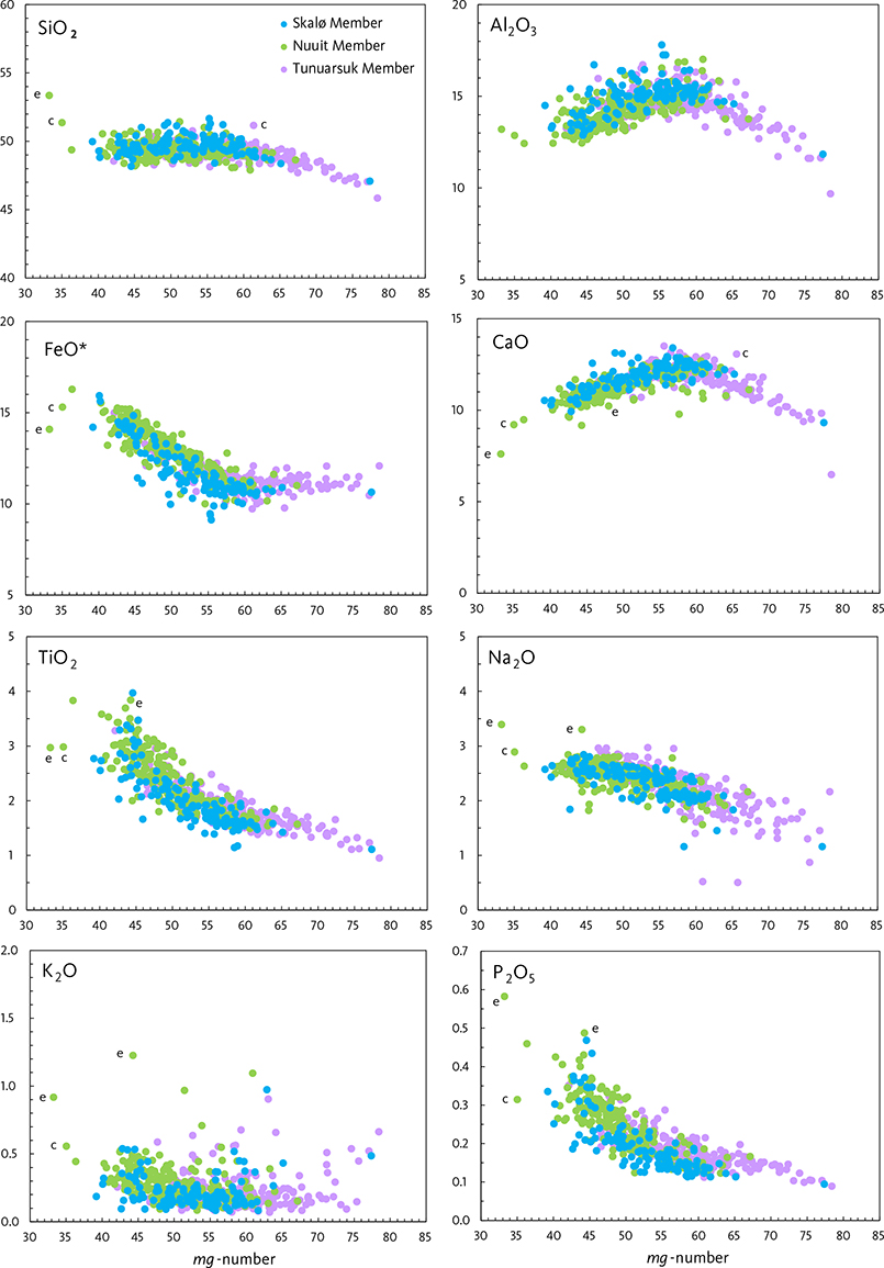
Fig. 76 Major-element variation diagrams for rocks of the Svartenhuk Formation. Crustally contaminated and enriched rocks are included in the main members because their major elements are as a rule not distinguishable from those of the main members. A few exceptions are labelled e: enriched, and c: crustally contaminated. Note that the abscissa is the mg-number (atomic 100×MgO/(MgO+FeO)), not the simple MgO as in the Vaigat Formation plots. The Skalø Member partly conceals the Nuuit and Tunuarsuk Members because it is plotted on top of them. Fractionation goes from right to left. The fractionation trends bend at mg-numbers around 57 (7–8 wt% MgO) because at that stage the fractionating olivine is joined by plagioclase and shortly afterwards by clinopyroxene. Vertical axes in wt% oxides.
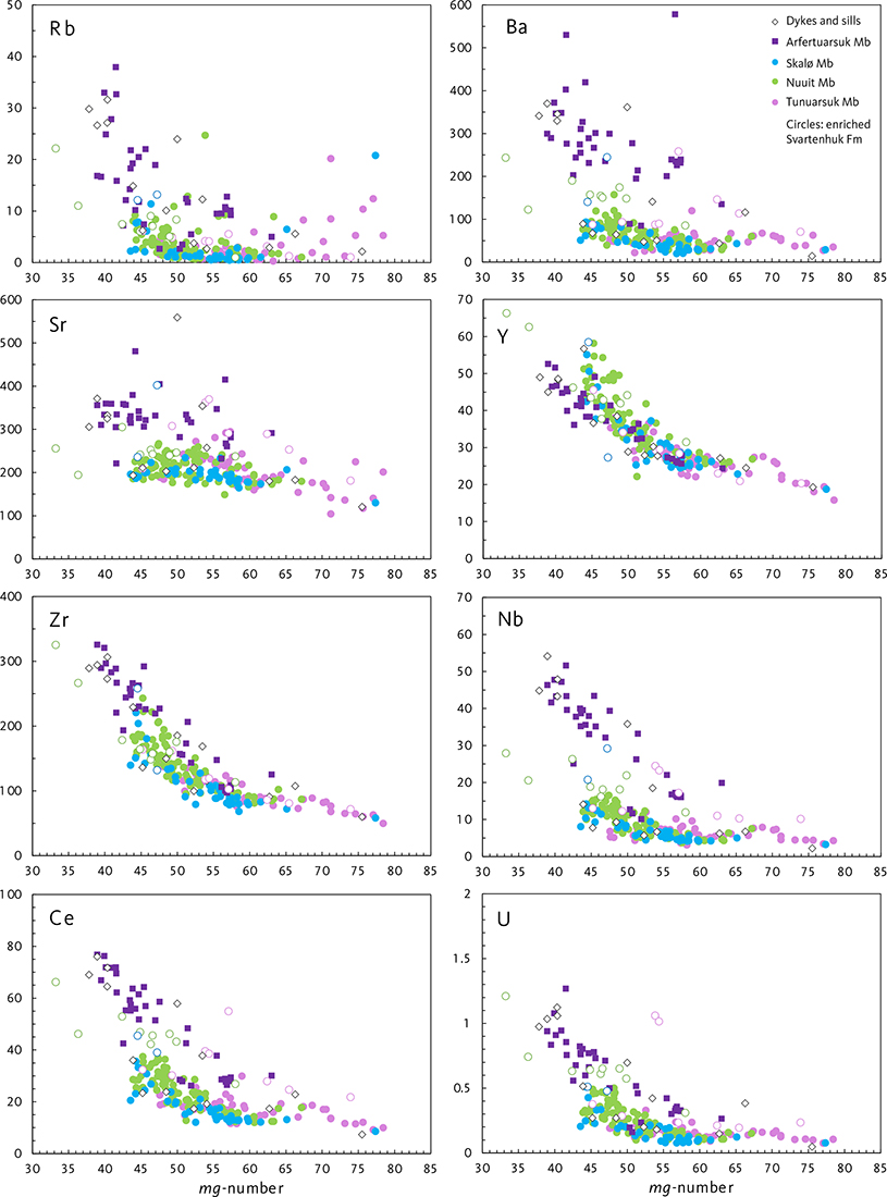
Fig. 77 Incompatible trace-element variation diagrams for rocks of the Svartenhuk and Naqerloq Formations and intrusions. The Tunuarsuk, Nuuit and Skalø Members have similar low element concentrations, but scattered lavas in all three members are enriched (open circles). The Arfertuarsuk Member has significantly higher concentrations of these elements. Intrusions compositionally similar to both formations are present. Vertical axes in ppm.
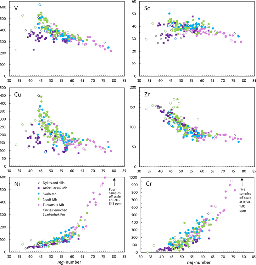
Fig. 78 Transition-element variation diagrams for rocks of the Svartenhuk and Naqerloq Formations and intrusions. Vertical axes in ppm.
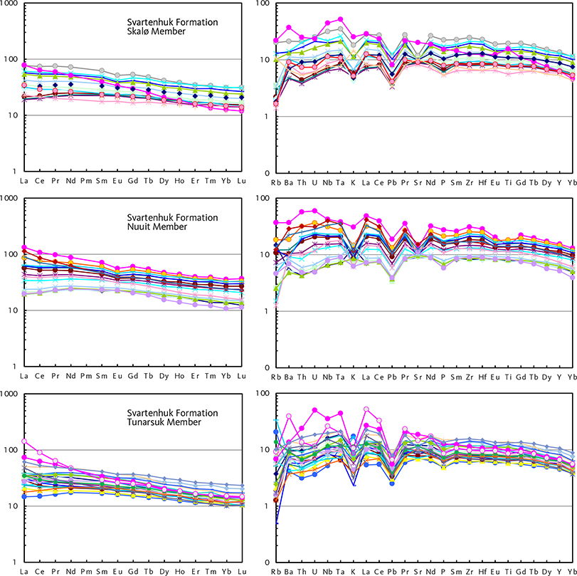
Fig. 79 REE and multi-element diagrams for representative rocks of the Svartenhuk Formation. The different colours of the curves are intended to aid the distinction of the individual samples. The magenta samples are incompatible-element-enriched. Note the particularly variable slope of the La–Sm limb of the REE curve for the Tunuarsuk Member. Left diagrams: chondrite normalised. Right diagrams: primitive mantle normalised. Normalisation factors from McDonough & Sun (1995).
Tunuarsuk Member
The Tunuarsuk Member comprises basalts with 5–10 wt% MgO grading into magnesian basalts with 10–12 wt% MgO and scattered picrites with 12–16 wt% MgO; a few rocks with up to 22 wt% MgO probably contain accumulated olivine. The average MgO content is 8.4 wt%, and the majority of the rocks are olivine normative. TiO2 is in the range 1.1–3.3 wt% with an average of 1.8 wt% TiO2, and with few exceptions the P2O5/TiO2 ratio is less than 0.11. The magmas were relatively depleted in incompatible trace elements such as Rb, Ba, Th, U, Nb, and light REE (Fig. 79). Some flows scattered throughout the region are distinctly enriched in these same elements, and very few flows (2 analyses) are crustally contaminated. Many REE and multi-element curves in Fig. 79 cross each other.
Nuuit Member
The Nuuit Member comprises basalts with 3.4–11 wt% MgO; only 3 out of 220 analyses have more than 9 wt% MgO and the average MgO content is 6.4 wt%. TiO2 is in the range 1.5–3.8 wt%, and the average TiO2 content is 2.4 wt%. The basalts are similar in composition to the more Ti-rich (TiO2 >2.0 wt%) basalts of the Tunuarsuk Member. The magmas were relatively depleted in incompatible trace elements such as Rb, Ba, Th, U, Nb and light REE, similar to the basalts of the Tunuarsuk Member. Some flows are enriched in the same elements, as discussed below. With the exception of these, the REE and multi-element curves in Fig. 79 are near-parallel and do not cross each other. This is in contrast to the same curves for the Tunuarsuk Member. A few scattered flows are crustally contaminated (4 analyses have SiO2 ≥51 wt%) and some more may be slightly contaminated.
Skalø Member
The Skalø Member comprises basalts with 4.5–10 wt% MgO; only 3 out of 127 analyses have more than 9 wt% MgO and the average MgO content is 6.5 wt%. TiO2 is in the range 1.1–3.5 wt%, and the average TiO2 content is 2.0 wt%. These compositions are very similar to those of the Nuuit Member, with slightly lower TiO2 in the Skalø Member. SiO2, Al2O3 and CaO range to slightly higher values than in the Nuuit Member, and many Skalø Member flows probably have relatively high contents of plagioclase. The magmas were relatively depleted in incompatible trace elements such as Rb, Ba, Th, U, Nb and light REE, similar to the basalts of the Tunuarsuk and Nuuit Members. A single flow is enriched in the same elements (Fig. 79). A few flows may be crustally contaminated; 6 analyses have SiO2 slightly higher than 51 wt% but still form part of the main compositional trends. With some exceptions the REE and multi-element curves in Fig. 79 are near-parallel and in this respect more similar to the curves of the Nuuit Member than to the Tunuarsuk Member.
The Skalø Member flows at Aputituut (profile 55) have relatively evolved compositions with high TiO2 and P2O5. The uppermost flow is extreme, with 4.0 wt% TiO2 and 0.47 wt% P2O5 at 5.7 wt% MgO. These values are similar to those in the overlying Arfertuarsuk Member. However, the trace-element ratios (REE and Zr-Nb-Y) clearly indicate that all the flows belong to the Skalø Member and the top flow is just highly evolved.
Discussion
The three volcanic members of the Svartenhuk Formation are compositionally very similar in their major and trace elements, and what defines the chemostratigraphy is the pattern of variation up-section. For example, the major difference between the Skalø and Nuuit Members is the variable TiO2 compositional profiles in the Nuuit Member compared to the near-constant profiles in the Skalø Member (Fig. 42).
The basalts of the Svartenhuk Formation represent relatively evolved magmas produced by fractionation in large, presumably deep-seated magma chambers. The decrease in Al2O3 and CaO and increase in FeO* in basalts with mg-number <57 reflect plagioclase fractionation (Fig. 76). The stratigraphic variations in TiO2 with height, as seen in Fig. 42, reflect slow variations in the input/output ratio of magma in the chamber.
The Tunuarsuk Member contains a significant component of picrites (with mg-numbers > c. 68), which the two younger members do not. This may be a result of decreasing magma production rates with time and thus longer residence times in the magma chambers. The very evolved lava flows on top of the Skalø Member on Aputituut (profile 55) mentioned above may be interpreted as the products of prolonged fractionation in a dying magma chamber that was no longer replenished from deeper levels.
Concentrations of incompatible elements increase with increasing fractionation of the magma, and all three members follow similar fractionation trends (Fig. 77). The significance of some relatively enriched samples and crossing and parallel REE and multi-element curves (Fig. 79) is discussed in the later section on enriched mantle components.
Naqerloq Formation
Arfertuarsuk Member
The Arfertuarsuk Member comprises tholeiitic basalts with relatively high contents of many incompatible elements. Their levels of silica saturation (5–20 wt% normative hypersthene, average 13.0 wt%) are only slightly lower than for the basalts of the Svartenhuk Formation (5–23 wt% normative hypersthene, average 16.2 wt%). They are thus not alkaline, as alkali basalts by definition do not have normative hypersthene (Le Maitre 2002). Most of them are not even transitional (i.e. with low normative hypersthene), although Icelandic basalts with similar compositions are often called transitional or alkaline. Major element variation diagrams for the Arfertuarsuk Member are shown in Fig. 80 and REE and multi-element diagrams in Fig. 81. Other trace-element data are included in the variation diagrams for the Svartenhuk Formation in Figs 77 and 78. The Arfertuarsuk trachyte and its inclusions are compositionally far off scale in the variation diagrams but are shown in the REE and multi-element diagrams. Representative chemical analyses are shown in Table 7.
| 251511 | Silicic magnesian basalt, 40 cm wide dyke in hyaloclastite of the Kakilisaat Member of the Vaigat Formation, probably a feeder dyke for this member. Profile 9, Peak 1078 m, eastern Svartenhuk Halvø. |
| 251387 | Olivine-phyric picrite, 3 m wide dyke in picrite lava flows of the Nunavik Member of the Vaigat Formation, probably a feeder dyke for this member. Qinngusaaq mountain, eastern Svartenhuk Halvø east of the Cretaceous boundary fault system. |
| 165242 | Olivine-phyric basalt, 5–6 m wide dyke in lava flows of the Skalø Member of the Svartenhuk Formation. Geochemical affinity to the Svartenhuk Formation. Profile 31, Aputituut Qaqqaat, south-central Svartenhuk Halvø. |
| 262982 | Plagioclase-glomerophyric basalt, 2 m wide, coast-parallel dyke in lava flows of the Skalø Member of the Svartenhuk Formation. Geochemical affinity to the Svartenhuk Formation. Profile 62, Sigguk, western Svartenhuk Halvø. |
| 262799 | Basalt dyke in lava flows of the Tunuarsuk Member of the Svartenhuk Formation. Geochemical affinity to the Svartenhuk Formation. Profile 64, Paannivik, southern Innerit peninsula. |
| 262994 | Aphyric basalt, 1.2 m wide, NW-striking dyke in lava flows of the Skalø Member of the Svartenhuk Formation. Geochemical affinity to the Naqerloq Formation. Profile 62, Sigguk, western Svartenhuk Halvø. |
| 263522 | Aphyric basalt dyke in lava flows of the Nuuit Member of the Svartenhuk Formation. Geochemical affinity to the Naqerloq Formation. Coastal cliff in profile 62, Sigguk, western Svartenhuk Halvø. |
| 278399 | Aphyric basalt, 2.5 m wide dyke in fault zone in lava flows of the Skalø Member of the Svartenhuk Formation. Geochemical affinity to the Naqerloq Formation. Profile 52, Nuuit Qaqqaat, north-western Svartenhuk Halvø. |
| 278320 | Basalt (dolerite), c. 50 m thick transgressive sill in lava flows of the Nuuit Member of the Svartenhuk Formation close to the Cretaceous boundary fault system (Fig. 6). Geochemical affinity to the Svartenhuk Formation. Profile 44c, Kuugaartorfik, northern Svartenhk Halvø. |
| 251385 | Plagioclase-glomerophyric basalt, up to 30 m thick sill in contact with gneiss and cutting pillow breccias and lava flows of the Vaigat Formation (Fig. 6). Geochemical affinity to the Svartenhuk Formation. Qinngusaaq mountain, eastern Svartenhuk Halvø east of the Cretaceous boundary fault system. |
| BB8-13D8 | Basalt dredged on the Upernavik escarpment in Baffin Bay at 73°05.5′ N, 58°09.1′ W, c. 80 km north-west of Upernavik. Full sample number BBS08-13D-8. Data from Polteau & Planke 2008. Note geochemical affinity to the Svartenhuk Formation. |
| BB8-12D2 | Basalt dredged on the Upernavik escarpment in Baffin Bay at 73°06.6′ N, 58°16.2′ W, c. 80 km north-west of Upernavik. Full sample number BBS08-12D-2. Data from Polteau & Planke 2008. Note geochemical affinity to the Svartenhuk Formation. |
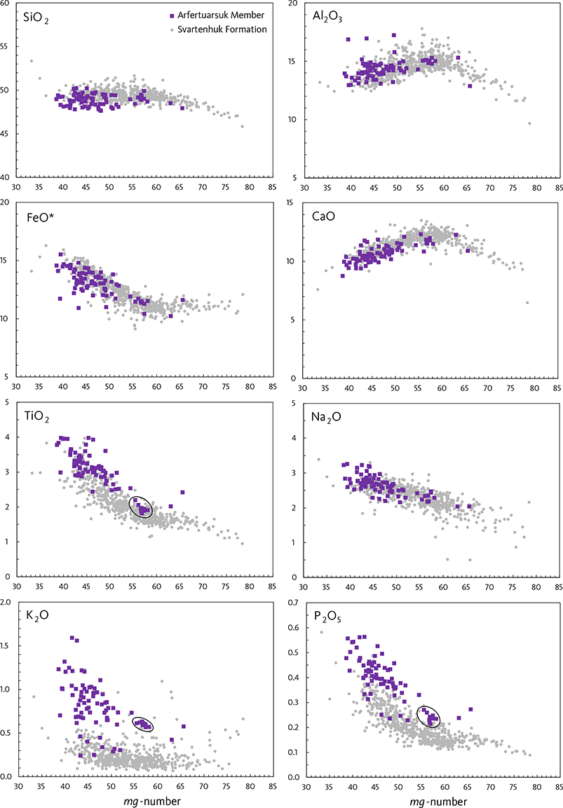
Fig. 80 Major-element variation diagrams for basalts of the Naqerloq Formation. A group of low-Ti basalts from the lowest part of the formation below the Arfertuarsuk trachyte flow is encircled in some diagrams. Data for the Svartenhuk Formation in grey for comparison. Vertical axes in wt% oxides.
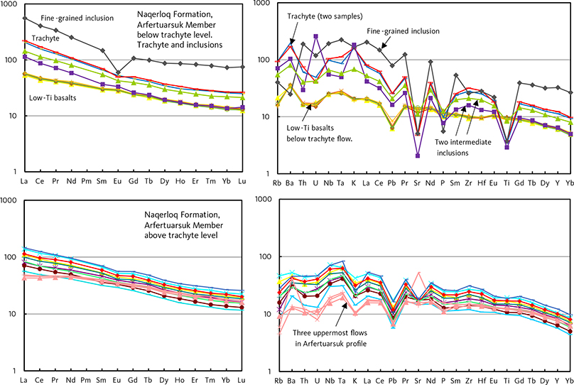
Fig. 81 REE and multi-element diagrams for representative rocks of the Naqerloq Formation. The different colours of the curves are intended to aid the distinction of the individual samples. Left diagrams: chondrite normalised. Right diagrams: primitive mantle normalised. Normalisation factors from McDonough & Sun (1995).
The Arfertuarsuk Member basalts have 3.8–8.6 wt% MgO with an average of 5.8 wt% MgO. TiO2 is in the range 1.8–4.0 wt%, and the average TiO2 content is 3.0 wt% (79 analyses). The member is thus on average slightly more evolved to lower MgO and higher TiO2 contents than the basalts of the Svartenhuk Formation, though there are large compositional overlaps for these elements (Fig. 80). K2O and P2O5 contents are notably high, with averages of 0.80 wt% K2O and 0.39 wt% P2O5 compared to the Svartenhuk Formation with averages of 0.24 wt% K2O and 0.21 wt% P2O5; there are only small compositional overlaps for these elements (Fig. 80). The P2O5/TiO2 ratio is useful for distinguishing samples that have not been analysed for trace elements because this ratio is on average 0.10 ± 0.01 for the Svartenhuk Formation and 0.13 ± 0.01 for the Arfertuarsuk Member.
The concentrations of other incompatible elements are also significantly higher in the basalts of the Arfertuarsuk Member than in those of the Svartenhuk Formation (Fig. 77). Moreover, many petrogenetically important element ratios such as P2O5/TiO2, Ba/Sr, Zr/Y, Nb/Y, Nb/Zr, Nb/La, La/Sm and Tb/Lu are significantly increased relative to basalts of the Svartenhuk Formation. All Arfertuarsuk Member basalts have LaN/SmN >1 (see also Figs 81, 83). The three uppermost flows in the Arfertuarsuk profile show a reversal to less enriched compositions with element ratios moved towards those in the Svartenhuk Formation; these three flows are distinguishable in several diagrams, particularly in Fig. 81.
The basalt flows below and above the trachyte level are compositionally different; those below the trachyte level are less evolved than those above it. The former flows have mg-numbers of 55–58 and plot in tight clusters in many diagrams (Figs 77, 80, 81).
The Arfertuarsuk trachyte flow has a very evolved composition and contains on average (5 analyses) 65.7 wt% SiO2, 0.83 wt% TiO2, 0.24 wt% MgO, 16.4 wt% Al2O3, 6.1 wt% Na2O, 5.2 wt% K2O and 0.26 wt% P₂O₅. It is anorthite normative and is thus not peralkaline; the normative content of albite + orthoclase is 85.5 %, reflecting the very high modal content of alkali feldspar. The trachyte magma had fractionated plagioclase, apatite and Fe-Ti oxide, as seen in the low concentrations of Sr, P, and Ti in the trace and multi-element diagrams (Fig. 81). The composition of the syenite xenolith (Table 7) shows that the xenoliths are closely related to the trachyte itself. They may represent fragments of deposits along the sidewall or in the top zone of the magma chamber where the trachyte melt fractionated.
The dark, fine-grained inclusion (Fig. 67) has the most extreme trace-element composition of all samples; its REE and multi-element patterns are parallel to those of the trachyte but at much higher levels, and relative losses of Rb, Ba, K, Sr, P, Eu and Ti are evident. One possible explanation for this is that the inclusion represents the result of filter pressing of residual liquid into available pockets (a sort of aplite veins without quartz) that in the process left feldspar behind. This would increase the concentration of incompatible elements in the liquid and also explain the negative Eu anomaly and the low Rb, Ba and K contents.
Intrusions
The relatively few trace-element analyses of dykes and sills are plotted in Figs 77, 78 and 82. Representative chemical analyses are shown in Table 8. A picrite dyke from the Nunavik Member and two strongly contaminated dykes similar to the Kakilisaat Member are easily identified chemically. The basaltic dykes form two compositional groups, one with a depleted and one with an enriched trace-element pattern, similar to the compositions of the Svartenhuk Formation and the Naqerloq Formation, respectively. Presumably the dykes of the two groups fed the respective formations, and the compositional difference is therefore also an age indicator. This is supported by the results of Chauvet et al. (2019) who presented 40Ar–39Ar ages for two dykes, one with ‘Svartenhuk chemistry’ and an age of 58.98 ± 0.93 Ma, and one with ‘Naqerloq chemistry’ and an age of 54.41 ± 0.99 Ma.

Fig. 82 REE and multi-element diagrams for dykes. The distinction between dykes of the Svartenhuk and Naqerloq Formations is described in the text; see also Fig. 85. The Ta peak in the multi-element pattern of the Nunavik Member picrite dyke is a slight contamination from the grinding vessel. Left diagram: chondrite normalised. Right diagram: primitive mantle normalised. Normalisation factors from McDonough & Sun (1995).
The large sills along the Cretaceous boundary fault system have compositions identical to the Svartenhuk Formation basalts (Table 8). We therefore consider that these intrusions represent the Svartenhuk Formation and thus are of late Paleocene age. This is in contrast to the sills intruded in a similar setting along the boundary fault on Nuussuaq, which are of Eocene age and have corresponding enriched compositions (Storey et al. 1998; Larsen et al. 2009).
Primary magmas, melting conditions and development with time
Vaigat Formation
As described above, the earliest volcanic unit deposited in eastern Svartenhuk Halvø, the Kakilisaat Member of the Vaigat Formation, is thoroughly crustally contaminated and also bears an imprint of an enriched component. The following unit, the Nerutusoq Member, is much less contaminated and contains a distinct enriched component. We consider that these two members are related and ultimately derived from similar parental magmas generated in the asthenosphere. Crustal contamination and trace-element enrichment are post-generation modifications, and consequently the asthenosphere-derived primary magma for the Kakilisaat and Nerutusoq Members cannot be characterised in detail. It was, however, picritic because the high Cr contents (>1000 ppm) in the least contaminated samples indicate derivation from magmas with ≥15 wt% MgO (Fig. 74). The simplest assumption is that the primary magma was similar to that of the overlying Nunavik Member. There is no evidence of smaller degrees of melting than in the Nunavik Member as suggested by Agranier et al. (2019). The post-melting modifications were achieved when the magmas intruded the local lithosphere and came into contact with crustal material and old enriched material. After this stage, the magmas of the Nunavik Member were able to pass unchanged through the lithosphere to the surface without stalling in magma chambers and becoming contaminated on the way.
The unmodified parental magma of the Nunavik Member was neither crustally contaminated nor did it contain a very enriched component. The strong compositional similarity to the Ordlingassoq Member of the Vaigat Formation on Nuussuaq and Disko includes the slope of both the light REE and the heavy REE patterns, with TbN/LuN averaging 1.61 ± 0.15 for the Nunavik Member and 1.63 ± 0.15 for the Ordlingassoq Member (Pedersen et al. 2018), indicating residual garnet in the source mantle (Fig. 83). The Sr-Nd isotope ratios are also similar, with both members mostly having 87Sr/86Sr = 0.7031–0.7034 and 143Nd/144Nd = 0.5129–0.5130 (Holm et al. 1993; Lightfoot et al. 1997; Larsen & Pedersen 2009; Agranier et al. 2019). The melting conditions for the primary magmas of the Vaigat Formation modelled by Larsen & Pedersen (2009) can thus be directly applied to the Svartenhuk Halvø area: the melts were formed beneath a lithospheric lid 80–100 km thick by 15–20% melting of an asthenospheric mantle with residual garnet in the source. The mantle was probably heterogeneous, with highly depleted parts giving rise to magmas with LaN/SmN <1 (Fig. 83) and Zr/Y and Nb/Y ratios below the Iceland field (Fig. 84). Less-depleted parts (the ‘Icelandic’ component of Holm et al. 1993) gave rise to magmas with LaN/SmN >1 (Fig. 83) and Zr/Y and Nb/Y ratios inside the Iceland field (Fig. 84), all within the same upwelling melting column. The resulting melts were picritic with about 17.5 wt% MgO and passed quickly through the lithosphere to the surface.
Svartenhuk Formation
The Svartenhuk Formation is 1–2 million years younger than the Vaigat Formation (Fig. 3). The change from dominantly picritic magmas of the Vaigat Formation to dominantly basaltic magmas of the Svartenhuk Formation must have involved establishment of large, deep magma chambers, probably at the mantle/crust boundary, in which the magmas fractionated. The same change took place between the Vaigat Formation and the Maligât Formation on Nuussuaq and Disko (Larsen & Pedersen 2009). Considering the age difference between the Maligât and Svartenhuk Formations (Fig. 3), this change was connected with the demise of the Vaigat Formation magmatism and could have been caused by changed tectonic conditions.
Conditions for magma generation in the asthenosphere stayed much the same, as evidenced by key incompatible element ratios. The light and heavy REE ratios for the Svartenhuk Formation plot mainly in the same area as the Nunavik Member (Fig. 83), suggesting similar melting conditions and that the primary magmas were still picritic. Samples with relatively high LaN/SmN ratios are discussed below. The Zr/Y vs. Nb/Y relations likewise suggest a mantle source similar to that of the Nunavik Member, with compositions plotting both within and below the Iceland field (Fig. 84). Sr-Nd isotope data for the Svartenhuk Formation are sparse, but the available results suggest isotope ratios similar to those of the Nunavik Member (O’Nions & Clarke 1972; Holm et al. 1993; Agranier et al. 2019).
A development with time is seen in decreasing heavy REE ratios. Whereas the Nunavik Member has an average TbN/LuN of 1.61 ± 0.15 (enriched samples excluded), TbN/LuN averages decrease from 1.56 ± 0.15 in the Tunuarsuk Member to 1.50 ± 0.18 in the Nuuit Member and 1.45 ± 0.08 in the Skalø Member (Fig. 83). As the mantle source was apparently similar to the source of the Nunavik Member, the temporal development in TbN/LuN must have been caused by melting dynamics and is interpreted to indicate a thinning lithospheric lid and shallowing melting in the garnet-to-spinel transition interval at 100–80 km depth, with decreasing amounts of garnet in the source.
The basalts of the Svartenhuk Formation show small but significant compositional differences from the uncontaminated basalts of the Maligât Formation (the Rinks Dal Member) on Disko and Nuussuaq. Whereas in practice the major elements are indistinguishable, trace-element ratios (Figs 83 and 84) show that the Svartenhuk Formation basalts are shifted to higher LaN/SmN and higher Nb/Y than most of the Maligât Formation basalts, although there is a partial overlap with the Maligât Formation. The Svartenhuk Formation basalts have LaN/SmN in the range 0.8–1.6 and therefore the light REE curves cross each other, as illustrated in Fig. 79. In contrast almost all Maligât Formation basalts have LaN/SmN <1 and near-parallel REE curves (Larsen & Pedersen 2009; Pedersen et al. 2018). The two formations are best discriminated in a plot of Ce/Y vs. Zr/Nb (Fig. 85) where they occupy separate fields for Zr/Nb <19; the overlap area with Zr/Nb >19 is only sparsely occupied by Svartenhuk Formation basalts. The Naqerloq Formation occupies a separate field. Based on this diagram, Larsen et al. (2016) and Pedersen et al. (2018, fig. 101) found that the basalt dykes on Disko and Nuussuaq are different from the basalt lava flows of the Maligât Formation but similar to the lava flows of the Svartenhuk and Naqerloq Formations. The dyke ages yield similar results (Fig. 3). The basalt dykes on Disko and Nuussuaq are therefore thought to have fed lava flows of the Svartenhuk and Naqerloq Formations, which must have been present in that area but are now removed by erosion.
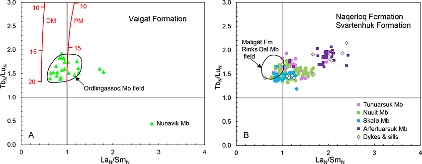
Fig. 83 REE cross plots and mantle melting models for the primary melts of the volcanic rocks of the Svartenhuk region; enriched and crustally contaminated samples are not plotted. Data are chondrite normalised (N). A: Nunavik Member of the Vaigat Formation. The black contour line is the field of the Ordlingassoq Member of the Vaigat Formation on Nuussuaq and Disko, with which the Nunavik Member is correlated. Red curves for melting in garnet facies are shown for depleted mantle (DM) and primitive mantle (PM). Numbers on the melting curves indicate degrees of melting (%). Same melting models as in Larsen & Pedersen (2009). Mantle modes and melting modes are from McKenzie & O’Nions (1991). Melting type is non-modal batch melting. DM trace-element starting composition is from McKenzie & O’Nions (1991). PM starting composition is from McDonough & Sun (1995). Partition coefficients are from McKenzie & O’Nions (1991). B: Svartenhuk and Naqerloq Formations. The black contour line is the field of the Rinks Dal Member of the Maligât Formation on Nuussuaq and Disko; note the difference in LaN/SmN between the Svartenhuk and Maligât Formations and their similar values of TbN/LuN.
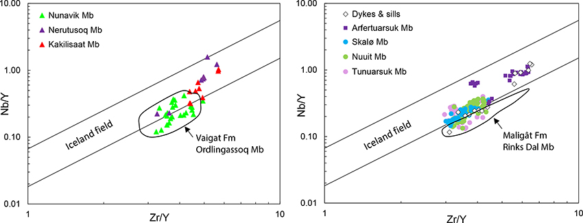
Fig. 84 Nb/Y vs. Zr/Y diagrams. A: Vaigat Formation. Black contour line is the field of the Ordlingassoq Member on Nuussuaq and Disko; note the exact resemblance to the Nunavik Member. B: Svartenhuk and Naqerloq Formations. Black contour line is the field of the Rinks Dal Member of the Maligât Formation on Nuussuaq and Disko; note the difference to the Svartenhuk Formation. The two parallel lines are the upper and lower bounds of the empirical field of data from Iceland, after Fitton et al. (1997). Rocks more depleted in Nb, such as many mid-ocean-ridge basalts, plot below the Iceland field. This diagram is useful for distinguishing between ‘Icelandic-type’ mantle sources and more depleted sources (e.g. Saunders et al. 1997; Fitton et al. 1997, 1998; Larsen & Pedersen 2009).
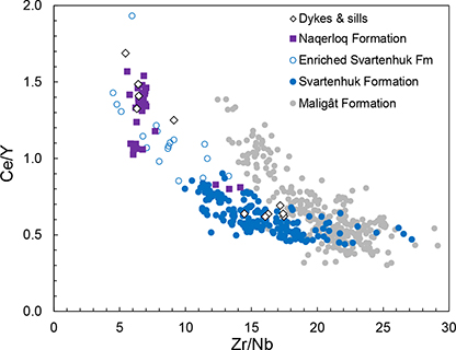
Fig. 85 Ce/Y vs. Zr/Nb diagram demonstrating the compositional differences between the Svartenhuk Formation and the Rinks Dal Member of the Maligât Formation on Disko and Nuussuaq. There is an area of overlap at high Zr/Nb, but for Zr/Nb <19 the separation of the two formations is good. The enriched Svartenhuk Formation basalts form a field extending towards the Naqerloq Formation, which occupies a separate field. The intrusions form two groups corresponding to the Svartenhuk and Naqerloq Formations.
A possible interpretation of Fig. 85 is that the Svartenhuk Formation basalts are mixed with an enriched component that is not present in the Maligât Formation basalts.
Naqerloq Formation
The Naqerloq Formation is 2–3 million years younger than the Svartenhuk Formation and the basalts of the two formations are significantly different. As described above, the Naqerloq Formation basalts have higher contents of incompatible elements (Figs 77, 80), higher Zr/Y and Nb/Y ratios plotting within the Iceland field (Fig. 84), higher La/Sm and Tb/Lu ratios (Fig. 83) with a TbN/LuN average of 1.85 ± 0.12, higher Ce/Y and lower Zr/Nb (Fig. 85). The 87Sr/86Sr ratios are slightly higher, around 0.7036, whereas the 143Nd/144Nd ratios are similar, 0.5129–0.5130 (Holm et al. 1992, p. 352 (Kanísut Member); Agranier et al. 2019). The Naqerloq Formation melts must have been generated either by smaller degrees of melting of a mantle source similar to the earlier source, or by melting of an enriched mantle source with higher contents of trace elements than primitive mantle (Fig. 83). Smaller degrees of melting of a mantle source similar to the earlier one should produce differences in the major elements, for example higher Na2O, which are not seen (Fig. 80), and the small differences in the Sr isotope ratios also favour a different mantle source. The melting modelling in Fig. 83 is based on depleted and primitive mantle compositions, and therefore the degrees and depths of melting of the primary magmas of the Naqerloq Formation cannot be modelled. It is possible that the degrees of melting were smaller than for the magmas of the Svartenhuk Formation, as suggested by Agranier et al. (2019), but this is not necessary to explain the data.
Storey et al. (1998) suggested that the ‘new’ mantle material from which the Naqerloq Formation was derived, was a remnant of the Iceland plume head left stranded beneath the West Greenland lithosphere. However, deposition of the Naqerloq Formation was not a local phenomenon, and volcanic rocks chemically similar to those of the Naqerloq Formation are found at several places in and around Greenland. They were drilled in the Delta-1 well offshore Svartenhuk Halvø (Nelson et al. 2015) and dredged in the Labrador Sea south of the Hecla High volcanic centre, which was interpreted as their most probable source (Fig. 1; Larsen & Dalhoff 2006). Ocean Drilling Program (ODP) Hole 918 offshore south-east Greenland contains a sill with a similar composition (Fitton et al. 1998), and the flood basalts in the Scoresbysund area include similar units, particularly the Rømer Fjord Formation (Larsen et al. 1989). As far as these rocks have been dated they are of earliest Eocene age, 56–50 Ma. Thus the ‘new’ mantle can rather be interpreted as a major part of the Iceland plume that spread through the North Atlantic during the phase of plate rearrangement and change of spreading direction from NE–SW to nearly N–S, that took place at the transition from Paleocene to Eocene (Oakey & Chalmers 2012).
Enriched mantle components
Basalts with a chemical imprint of material enriched in the most incompatible trace elements occur in all members of the Vaigat and Svartenhuk Formations and are most common in the Tunuarsuk Member. The patterns of enrichment are variable, as illustrated by the multi-element patterns for selected samples in Fig. 86. Compared to the normal basalts with NbN/LaN ~ 1 , some samples have NbN/LaN <1, others have NbN/LaN >1. Some samples have Ba peaks, one has a U peak, the Nunavik picrite has a distinct Nb–Ta peak, some samples have no extra Pb and Ti shows both peaks and troughs. All samples have increased light REE (La–Sm), and many except the enriched Nuuit Member samples have steeper heavy REE limbs (Gd–Yb) and even lower Y and Yb than the normal basalt. Because of the variability it has not been possible to make a rigid definition of ‘enriched’ samples; they are generally characterised by having high Nb and high La–Nd relative to their degree of fractionation.
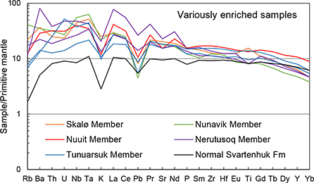
Fig. 86 Multi-element diagram for selected samples showing variable patterns of element enrichment. Ratios between normalised elements such as Nb/La and Th/U vary from greater than one to less than one. Two samples show no Pb enrichment, Ti shows troughs, plains or peaks, and the steepness of the Gd–Yb limb is variable. Samples as as follows: Nunavik Member: 251527 (βo1 flow); Nerutusoq Member: 181013 and 263823; normal Svartenhuk Formation: 566518; Tunuarsuk Member: 251333 and 262815; Nuuit Member: 251338; Skalø Member: 278622.
Three enriched samples from the Nunavik and Tunuarsuk Members were analysed for Sr and Nd isotopes by Holm et al. (1993); they have high 87Sr/86Sr ratios (0.7036–0.7041) and low 143Nd/144Nd ratios (0.5128–0.5129) relative to the normal basalts and picrites, indicating a separate source of the enriched material.
Sporadic addition of enriched lithospheric material
In the Nunavik, Tunuarsuk and Skalø Members chemically enriched lavas occur as individual flows surrounded by flows that are chemically normal. We consider it most probable that the magmas of these flows have acquired their enrichment on their way to the surface after they left the melting column (Nunavik Member, the βo1 marker unit) and the deep-seated magma chambers (Tunuarsuk and Skalø Members). The enriched components therefore resided in the lithospheric mantle or crust and represent veins or dykes of older alkaline rocks, which could easily be partially melted and assimilated by batches of passing hot basaltic and picritic melts on their way to the surface. The resulting enrichment patterns would depend on the melting mineral assemblage. Older alkaline carbonate-rich rocks are reported from the region, e.g. from the islands of Qinngusaaq and Qeqertarsuaq, both c. 30 km east of southern Svartenhuk Halvø (Henderson & Pulvertaft 1987; Knudsen et al. 2010; Mott et al. 2013).
A similar origin has been proposed for variously enriched rocks akin to those on Svartenhuk Halvø from the Manîtdlat Member in the Vaigat Formation on Disko, some 150 km farther south (Larsen et al. 2003; this minor member is associated with the Ordlingassoq Member but not listed in Fig. 3). In detail, however, the occurrences are different; the rocks of the Manîtdlat Member are mostly more enriched than those on Svartenhuk Halvø, and their Sr-Nd isotope compositions are dissimilar to the few results published by Holm et al. (1993).
An enriched asthenospheric mantle component
The Nuuit Member shows a systematic up-section variation of the most incompatible trace elements in most analysed profiles (Fig. 87). The basalts identified as enriched all occur at the base of the member, but not all basal samples are classified as enriched. The lowest samples, whether they are enriched or normal, have relatively high LaN/NdN, Nb/Zr, Ba/Sr and other incompatible-element ratios, and with few exceptions the ratios decline systematically up-section. The variation is most clearly seen in the LaN/NdN ratio (Fig. 87). This development is seen in six out of eight profiles analysed systematically for trace elements. In contrast, the heavy REE ratios (TbN/LuN) of all samples are near-constant, suggesting melt generation at near-similar depths. There is no correlation between LaN/NdN and the degree of fractionation of the erupted magma as indicated by the MgO and TiO2 contents (compare Fig. 87 with the TiO2 profiles in Fig. 42). If the cause of the variation is increasing degrees of melting up-section there should also be differences in other elements, which are not seen. The simplest explanation of the data is that the melting asthenospheric mantle comprised two components, one relatively depleted in incompatible trace elements and another relatively enriched in such elements. Melt from the enriched component was mainly produced at the start of the Nuuit Member and gradually diminished during continued melting.
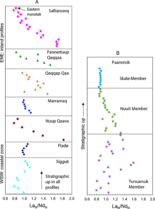
Fig. 87 Stratigraphic variation up-section of LaN/NdN (chondrite normalised) in eight densely sampled and analysed profiles. A: Data for the Nuuit Member in seven profiles stacked vertically in a WSW–ENE succession. The lowest profiles are those within the coastal zone and the highest profiles are those farthest inland. Different colours and shapes are for clarity. B: Up-section variation through the whole Svartenhuk Formation in the Paannivik profile.
The two profiles closest to the coast (Sigguk and Fladø) do not show the same pattern as the others, which suggests separate magma chambers beneath the coastal and inland areas.
Melting and mixing relations in the Svartenhuk Formation
Only one analysed sample profile covers all three volcanic members of the Svartenhuk Formation: the Paannivik profile (64). The plot of LaN/NdN vs. stratigraphic height for this profile (Fig. 87B) shows that the three members have different styles of up-section variation. The Tunuarsuk Member shows a large compositional spread and no systematic up-section variation; the Nuuit Member shows the systematic decrease in LaN/NdN described above, and the Skalø Member has constant LaN/NdN throughout. Other analysed profiles through the Tunuarsuk and Skalø Members are less complete but indicate the same pattern of overall variation as at Paannivik. The data may be interpreted in terms of melting and mixing dynamics. In the Tunuarsuk Member, the melt batches from the mantle did not mix efficiently in the magma chamber where they fractionated, and both very depleted melts with LaN/NdN around 0.8 and very enriched melts with LaN/NdN up to 1.6 were preserved and erupted. This may have been caused by relatively short residence times in the magma chamber, which also led to more magnesian basalts than in the two subsequent members. In the Nuuit Member mixing of the individual melt batches intruded into the magma chamber became much more efficient, though not complete in the beginning, and at the same time the amount of enriched melt gradually diminished with further melting. In the Skalø Member, mixing was either perfect or the enriched mantle component had been exhausted; the low LaN/NdN ratio of 0.9 suggests the latter.
Our interpretations can be tested with isotope data, which are, however, currently not available. A corollary of the interpretations is that the enriched flows in the Tunuarsuk Member may have acquired their enrichment in two different ways, in the asthenosphere and in the lithosphere, which would contribute to their observed compositional variability. The existence of one or more enriched components in the basalts is precisely the reason why basalts of the Svartenhuk Formation can be chemically distinguished from basalts of the Maligât Formation, which lack such a component.
Concluding remarks
The volcanic succession in the northern part of the Nuussuaq Basin, on Svartenhuk Halvø and the areas north and north-east of this, was deposited during a series of geological events that affected the entire basin. The northern succession is therefore in general correlatable to the more southerly parts, but on the formation and member level there are also distinct differences in the geological evolution.
Volcanism on Svartenhuk Halvø may have started somewhat later than in the southern Nuussuaq Basin. The Nunavik Member correlates excellently with the upper part of the Vaigat Formation (Ordlingassoq Member) in the south, but older members of the Vaigat Formation exposed on Disko and Nuussuaq may be present at depth beneath the western Svartenhuk Halvø. At the end of the volcanic activity of the Vaigat Formation, the Mg-rich volcanic rocks formed a N–S elongated, mainly subaerially exposed dome that extended for c. 250 km from central Disko and Nuussuaq over Ubekendt Ejland, where thicknesses appear to be greatest, and across Svartenhuk Halvø to the southern Innerit peninsula, where the formation thins and tapers out.
After this stage, the conditions that had allowed picritic magmas to pass relatively unmodified to the surface in the whole Nuussuaq Basin changed. Deep magma chambers developed, in which the picritic magmas evolved to basaltic compositions, and the modes of evolution in the north and south diverged. Volcanism in the south continued with the extrusion of the basalts of the Maligât Formation, whereas in the north there was a hiatus during which quartzofeldspathic sediments were deposited. When volcanism resumed in the north, the basalts of the Svartenhuk Formation were deposited; the bulk of these are younger than the Maligât Formation. The three members of the Svartenhuk Formation are mappable because of morphological and colour differences. They show a large compositional overlap, but up-section variations produced by processes in the magma chambers support the individual nature of the members. The Svartenhuk Formation is probably extensively present offshore where it has been recognised in drill hole Alpha-1 and in dredged samples. Onshore the formation is also present on Ubekendt Ejland and probably in western Nuussuaq and as dykes on Disko and Nuussuaq.
At the transition from Paleocene to Eocene time, there was a volcanic hiatus that lasted for c. 1–2 Ma during which tectonic movements and reorganisation of plate spreading directions took place. Volcanism resumed with extrusion of the Naqerloq Formation basalts, which are compositionally different from the Paleocene basalts and were generated in a different mantle. Lava successions of the Naqerloq Formation are preserved only in the westernmost parts of the Nuussuaq Basin from Hareøen to Svartenhuk Halvø and mainly as erosional remnants, but dykes throughout Disko, Nuussuaq and Svartenhuk Halvø show that the formation was erupted over large parts of the Nuussuaq Basin. It is probably also extensively present offshore where it has been recognised in the drill hole Delta-1.
Further studies in the northern part of the Nuussuaq Basin may provide a better understanding of some aspects of the geology. First, the volcanic succession east of c. 54°W is poorly known. Our present knowledge is based on extensive photogrammetric studies whereas ground studies only comprise two sampled profiles. Second, formation boundaries with sediments should be systematically investigated to provide a more precise understanding of the events that took place at the time; this is particularly true for the Paleocene–Eocene transition. Third, the uncertainties concerning the internal stratigraphy of the Naqerloq Formation in the western Svartenhuk Halvø area may be resolved with more detailed work. Fourth, the northernmost area (north of 72°30′N) remains completely unvisited.
Acknowledgements
Over the long span of years, we have been indebted to many persons. In the field, Karl Aage Jørgensen and Troels Nielsen made substantial and invaluable contributions to sampling and logging of basalt profiles and Frank Andreasen provided information on interbasaltic sediments. We also owe our thanks to expedition leader Gilroy Henderson and skipper Andreas Viðstein on M/S Steenstrup, as well as to vice director Flemming Getreuer Christiansen and department leaders Niels Henriksen, Christian Knudsen and Stefan Bernstein for general GGU/GEUS support. Hans Jepsen provided guidance in the use of the Kern PG2 stereoplotter in GGU’s photogeological laboratory. Jørgen Kystol and Ib Sørensen and in later years Olga Nielsen at GGU/GEUS’s rock geochemical laboratory maintained the constantly high quality of the XRF and ICP-MS analyses of the rocks.
We are particularly grateful to the late Chris Pulvertaft for his pioneering field work in the region in the 1960s and for his unswerving support and interest in Svartenhuk Halvø.
We extend our thanks to Erik Vest Sørensen, Kristian Svennevig and Michelle de Wolfe for their recent sampling of some key localities and discussions of the field relations. The two first-named also generously put their more recent photographs at our disposal, as did Asger Ken Pedersen. Henrik Nøhr-Hansen carried out the micropalaeontological analyses of sediment samples. Jette Halskov patiently and expertly prepared the drawings and annotated the photographs. The pen drawings in Figs 14–18 were digitised and further adjusted by Ane Asmussen. Jacob Bendtsen helped with the Photoshop work. The digital elevation map in Fig. 9 was constructed by Christian Brogaard Pedersen. An early draft of the manuscript and some figures were carefully commented and amended by Stuart Watt. Special thanks go to Asger Ken Pedersen for numerous discussions throughout the work and for comments on the manuscript. We are further grateful to the reviewers David Peate and Richard Wilson for their helpful and constructive reviews. JGL extends his thanks to his family for their year-long patience.
Additional information
Funding statement
The work was primarily funded by GGU and later GEUS. The report by Larsen & Larsen (2010) was funded by a consortium of oil companies.
Competing interests
The authors declare no competing interests.
Author contributions
JGL: Field work, map compilation, writing - original draft, revision. LML: Writing - revision of original draft, new chapter on geochemistry and petrology, figures, revision, editing.
Additional files
Four supplementary files are available at: https://doi.org/10.22008/FK2/EF2NKR
References
Abdelmalak, M.M., Geoffroy, L., Angelier, J., Bonin, B., Callot, J.P., Gélard, J.P. & Aubourg, C. 2012: Stress fields acting during lithosphere breakup above a melting mantle: A case example in West Greenland. Tectonophysics 581, 132–143. https://doi.org/10.1016/j.tecto.2011.11.020
Agranier, A., Maury, R.C., Geoffroy, L., Chauvet, F., Le Gall, B. & Viana, A.R. 2019: Volcanic record of continental thinning in Baffin Bay margins: Insights from Svartenhuk Halvø Peninsula basalts, West Greenland. Lithos 334–335, 117–140. https://doi.org/10.1016/j.lithos.2019.03.017
Andreasen, F. 1981: Sedimentological observations in Cretaceous and Tertiary rocks in the northern part of the West Greenland sedimentary basin. Rapport Grønlands Geologiske Undersøgelse 105, 26–27. https://doi.org/10.34194/rapggu.v105.7746
Bonow, J.M. 2005: Re-exposed landforms in the Disko region, West Greenland – disregarded data for estimation of glacial erosion and uplift modelling. Geomorphology 72, 106–127. https://doi.org/10.1016/j.geomorph.2005.05.006
Bonow, J.M., Japsen, P., Lidmar-Bergström, K., Chalmers, J.A. & Pedersen, A.K. 2006: Cenozoic uplift of Nuussuaq and Disko, West Greenland – elevated erosion surfaces as uplift markers of a passive margin. Geomorphology 80, 325–337. https://doi.org/10.1016/j.geomorph.2006.03.006
Chalmers, J.A. & Pulvertaft, T.C.R. 2001: Development of the continental margins of the Labrador Sea: a review. In: Wilson, R.C.L. et al. (eds): Non-volcanic rifting of continental margins: a comparison of evidence from land and sea. Geological Society, London: Special Publications 187, 77–105. https://doi.org/10.1144/gsl.sp.2001.187.01.05
Chalmers, J.A., Pulvertaft, T.C.R., Marcussen, C. & Pedersen, A.K. 1999: New insight into the structure of the Nuussuaq Basin, central West Greenland. Marine and Petroleum Geology 16, 197–224. https://doi.org/10.1016/s0264-8172(98)00077-4
Chauvet, F., Geoffroy, L., Guillou, H., Maury, R.C., Le Gall, B., Agranier, A. & Viana, A. 2019: Eocene continental breakup in the Baffin Bay. Tectonophysics 757, 170–186. https://doi.org/10.1016/j.tecto.2019.03.003
Christiansen, F.G., Boesen, A., Bojesen-Koefoed, J., Dalhoff, F., Dam, G., Neuhoff, P.S., Pedersen, A.K., Pedersen, G.K., Stannius, L.S. & Zinck-Jørgensen, K. 1998: Petroleum geological activitites onshore West Greenland in 1997. Geology of Greenland Survey Bulletin 180, 10–17. https://doi.org/10.34194/ggub.v180.5079
Christiansen, F.G. et al. 2000: Petroleum geological activitites in West Greenland in 1999. Geology of Greenland Survey Bulletin 186, 88–96. https://doi.org/10.34194/ggub.v186.5221
Clarke, D.B., 1968: Tertiary basalts of the Baffin Bay area. Unpublished Ph.D. thesis, University of Edinburgh, 122 pp.
Clarke, D.B. 1970: Tertiary basalts of the Baffin Bay: possible primary magma from the mantle. Contributions to Mineralogy and Petrology 25, 203–224. https://doi.org/10.1007/bf00371131
Clarke, D.B. & Pedersen, A.K. 1976: Tertiary volcanic province of West Greenland. In: Escher, A. & Watt, W.S. (eds): Geology of Greenland, 364–385. Copenhagen: Geological Survey of Greenland.
Clarke, D.B. & Upton, B.G.J. 1971: Tertiary basalts of Baffin Island: Field relations and tectonic setting. Canadian Journal of Earth Sciences 8, 248–258. https://doi.org/10.1139/e71-025
Clarke, D.B., Muecke, G.K. & Pe-Piper, G. 1983: The lamprophyres of Ubekendt Ejland, West Greenland: products of renewed partial melting or extreme differentiation? Contributions to Mineralogy and Petrology 83, 117–127. https://doi.org/10.1007/bf00373084
Croxton, C.A. 1978: Report of field work undertaken between 69° and 72°N, central West Greenland in 1975 with preliminary palynological results. Open-File Report, Grønlands Geologiske Undersøgelse 78/1, 80 pp.
Dam, G. & Sønderholm, M. 2021: Tectonostratigraphic evolution, palaeogeography and main petroleum plays of the Nuussuaq BasIn: An outcrop analogue for the Cretaceous–Palaeogene rift basins offshore West Greenland. Marine and Petroleum Geology 129, 105047, 33 pp. https://doi.org/10.1016/j.marpetgeo.2021.105047
Dam, G., Pedersen, G.K., Sønderholm, M.S., Midtgaard, H.H., Larsen, L.M., Nøhr-Hansen, H. & Pedersen, A.K. 2009: Lithostratigraphy of the Cretaceous–Paleocene Nuussuaq Group, Nuussuaq Basin, West Greenland. Geological Survey of Denmark and Greenland Bulletin 19, 1–171. https://doi.org/10.34194/geusb.v19.4886
Dam, G., Sønderholm, M. & Sørensen, E.V. 2020. Inherited basement canyons: Impact on sediment distribution in the North Atlantic. Terra Nova 32, 272–280. https://doi.org/10.1111/ter.12459
Drever, H.I. 1953: The origin of some ultramafic rocks: a preliminary survey of the evidence for and against gravity accumulation of olivine. Meddelelser fra Dansk Geologisk Forening 12, 227–229.
Drever, H.I. 1956: The geology of Ubekendt Ejland, West Greenland. II. The picritic sheets and dykes of the east coast. Meddelelser om Grønland 137(4), 1–41.
Drever, H.I. & Game, P.M. 1948: The geology of Ubekendt Ejland, West Greenland, part I, a preliminary review. Meddelelser om Grønland 134(8), 1–35.
Drever, H.I. & Johnston, R. 1957: Crystal growth of forsteritic olivine in magmas and melts. Transactions of the Royal Society of Edinburgh 63, 289–315. https://doi.org/10.1017/s0080456800009509
Escher, J. 1985: Geological map of Greenland, 1:500 000, Sheet 4 Upernavik Isfjord. Copenhagen: Geological Survey of Denmark and Greenland.
Fitton, J.G., Saunders, A.D., Norry, M.J., Hardarson, B.S. & Taylor, R.N. 1997: Thermal and chemical structure of the Iceland plume. Earth and Planetary Science Letters 153, 197–208. https://doi.org/10.1016/s0012-821x(97)00170-2
Fitton, J.G., Saunders, A.D., Larsen, L.M., Hardarson, B.S. & Norry, M.J. 1998: Volcanic rocks from the Southeast Greenland margin at 63°N: composition, petrogenesis and mantle sources. In: Saunders, A.D., Larsen, H.C. & Wise, S.H. (eds): Proceedings of the Ocean Drilling Program, Scientific Results 152: College Station, TX (Ocean Drilling Program), 331–350. https://doi.org/10.2973/odp.proc.sr.152.233.1998
Funck, T., Gohl, K., Damm, V. & Heyde, I. 2012: Tectonic evolution of southern Baffin Bay and Davis Strait: Results from a seismic refraction transect between Canada and Greenland. Journal of Geophysical Research 117(B4). https://doi.org/10.1029/2011jb009110
Geoffroy, L., Callot, J.-P., Scaillet, S., Skuce, A., Gélard, J.P., Ravilly, M., Angelier, J., Bonin, B., Perrot, K. & Lepvrier, C. 2001: Southeast Baffin volcanic margin and the North American-Greenland plate separation. Tectonics 20, 566–584. https://doi.org/10.1029/2001tc900003
Giesecke, C. 1823: XIX. On the Mineralogy of Disko Island. Transactions of the Royal Society of Edinburgh 9(2), 263–272. https://doi.org/10.1017/S0080456800030891
Giesecke, K.L. 1910: Mineralogisches Reisejournal über Grönland 1806–1813. Meddelelser om Grønland 35, 1–478.
Gill, R.C.O., Pedersen, A.K. & Larsen, J.G. 1992: Tertiary picrites in West Greenland: melting at the periphery of a plume? In: Storey, B.C., Alabaster, T. & Pankhurst, R.J. (eds): Magmatism and the Causes of Continental Break-up. Geological Society, London: Special Publications 68, 335–348. https://doi.org/10.1144/gsl.sp.1992.068.01.21
Govindaraju, K. 1994. 1994 compilation of working values and sample descriptions for 383 geostandards. Geostandards Newsletter 18, Special Issue 1, 1–158. https://doi.org/10.1046/j.1365-2494.1998.53202081.x-i1
Gradstein, F.M., Ogg, J.G. & Smith, A.G. (eds) 2004: A Geologic Time Scale 2004. Cambridge: Cambridge University Press, 610 pp. https://doi.org/10.1017/cbo9780511536045
Gregersen, U., Hopper, J.R. & Knutz, P.C. 2013: Basin seismic stratigraphy and aspects of prospectivity in the NE Baffin Bay, Northwest Grenland. Marine and Petroleum Geology 46, 1–18. https://doi.org/10.1016/j.marpetgeo.2013.05.013
Gregersen, U., Knutz, P.C., Nøhr-Hansen, H., Sheldon, E. & Hopper, J.R. 2019: Tectonostratigraphy and evolution of the West Greenland continental margin. Bulletin of the Geological Society of Denmark 67, 1–21. https://doi.org/10.37570/bgsd-2019-67-01
Grocott, J. & Pulvertaft, T.C.R. 1990: The Early Proterozoic Rinkian belt of central West Greenland. In: Lewry, J.F. & Stauffer, M.R. (eds): The Early Proterozoic Trans-Hudson Orogen of North America. Geological Association of Canada, Special Paper 37, 443–463.
Guarnieri, P., Baker, N., Rosa, D. & Sørensen, E.V. 2022a: Geological Map of Greenland 1:100 000 Nuugaatsiaq 71 V.2 Nord. Copenhagen: Geological Survey of Denmark and Greenland. https://doi.org/10.22008/FK2/PGSMJH
Guarnieri, P., Baker, N., Rosa, D. & Sørensen, E.V. 2022b: Geological Map of Greenland 1:100 000 Pannertooq 72 V.2 Syd. Copenhagen: Geological Survey of Denmark and Greenland. https://doi.org/10.22008/FK2/IBHIZL
Guarnieri, P., Rosa, D., Thrane, K., Kokfelt, T.F., Sørensen, E.V. & Baker, N. 2022c: Paleoproterozoic Cordilleran-Type Tectonics in central West Greenland. Abstract EGU22-13531, EGU General Assembly 2022.
Hald, N. 1976: Early Tertiary flood basalts from Hareøen and western Nûgssuaq, West Greenland. Bulletin Grønlands Geologiske Undersøgelse 120, 1–36. https://doi.org/10.34194/bullggu.v120.6662
Hald, N. & Pedersen, A.K. 1975: Lithostratigraphy of the Early Tertiary volcanic rocks of central West Greenland. Rapport Grønlands Geologiske Undersøgelse 69, 17–24. https://doi.org/10.34194/rapggu.v69.7407
Hansen, J.M. 1977: Dinoflagellate stratigraphy and echinoid distribution in Upper Maastrichtian and Danian deposits from Denmark. Bulletin of the Geological Society of Denmark 26, 1–26. https://doi.org/10.37570/bgsd-1976-26-01
Hansen, J.M. 1980: Stratigraphy and structure of the Paleocene in central West Greenland (onshore) and Denmark. Unpublished lic.scient. thesis, Geological Institute, University of Copenhagen.
Henderson, G. 1973: The geological setting of the West Greenland Basin in the Baffin Bay region. Geological Survey of Canada Paper 71-23, 521–544. https://doi.org/10.4095/105243
Henderson, G & Pulvertaft, T.C.R. 1987: Geological map of Greenland, 1:100 000, Mârmorilik 71 V. 2 Syd, Nûgâtsiaq 71 V. 2 Nord, Pangnertôq 72 V. 2 Syd. Descriptive text, 72 pp. Copenhagen: Geological Survey of Greenland.
Henderson, G., Schiener, E.J., Risum, J.B., Croxton, C.A. & Andersen, B.B. 1981: The West Greenland Basin. In: Kerr, J.W. (ed): Geology of the North Atlantic Borderlands. Memoir, Canadian Society of Petroleum Geologists 7, 399–428.
Herzberg, C. & O’Hara, M.J. 1998: Phase equilibrium constraints on the origin of basalts, picrites, and komatiites. Earth-Science Reviews 44, 39–79. https://doi.org/10.1016/s0012-8252(98)00021-x
Herzberg, C. & O’Hara, M.J. 2002: Plume-associated ultramafic magmas of Phanerozoic age. Journal of Petrology 43, 1857–1883. https://doi.org/10.1093/petrology/43.10.1857
Herzberg, C., Asimow, P.D., Arndt, N., Niu, Y., Lesher, C.M., Fitton, J.G., Cheadle, M.J. & Saunders, A.D. 2007: Temperatures in ambient mantle and plumes: Constraints from basalts, picrites, and komatiites. Geochemistry, Geophysics, Geosystems 8, 34 pp. https://doi.org/10.1029/2006gc001390
Holm, P.M., Hald, N. & Nielsen, T.F.D. 1992: Contrasts in composition and evolution of Tertiary CFBs in West and East Greenland and their relations to the establishment of the Icelandic mantle plume. In: Storey, B.C., Alabaster, T. & Pankhurst, R.J. (eds): Magmatism and the Causes of Continental Break-up. Geological Society London: Special Publications 68, 349–362. https://doi.org/10.1144/gsl.sp.1992.068.01.22
Holm, P.M., Gill, R.C.O., Pedersen, A.K., Larsen, J.G., Hald, N., Nielsen, T.F.D. & Thirlwall, M.F. 1993: The Tertiary picrites of West Greenland: contributions from ‘Icelandic’ and other sources. Earth and Planetary Science Letters 115, 227–244. https://doi.org/10.1016/0012-821x(93)90224-w
Howat, I., Negrete, A. & Smith, B. 2014: The Greenland Ice Mapping Project (GIMP) land classification and surface elevation data sets. The Cryosphere 8, 1509–1518. https://doi.org/10.5194/tc-8-1509-2014
Jørgensen, K.A. 1981: Dagbog vedrørende kortlægning på Nord Svartenhuk. 45 pp + maps. Unpublished field diary, Geological Survey of Greenland, Copenhagen.
Jørgensen, K.A. 1982: Towards a refined stratigraphy for the basalts of Svartenhuk Halvø. Rapport Grønlands Geologiske Undersøgelse 110, 19–22. https://doi.org/10.34194/rapggu.v110.7789
Knudsen, C., Brooks, K. & Larsen, L.M. 2010: Timing and nature of dykes in North-West Greenland adjacent to the Melville Bay, with emphasis on possible relations to tectonomagmatic events in the offshore basins. Danmarks og Grønlands Geologiske Undersøgelse Rapport 2010/13, 36 pp.
Koch, L. 1929: Stratigraphy of Greenland. Meddelelser om Grønland 73, 205–320.
Kystol, J. & Larsen, L.M. 1999: Analytical procedures in the Rock Geochemical Laboratory of the Geological Survey of Denmark and Greenland. Geology of Greenland Survey Bulletin 184, 59–62. https://doi.org/10.34194/ggub.v184.5230
Larsen, J.G. 1977: Transition from low potassium olivine tholeiites to alkali basalts on Ubekendt Ejland. Meddelelser om Grønland 200(1), 1–42.
Larsen, J.G. 1981a: Stratigraphy and structure of the Tertiary volcanic rocks of southern and eastern Svartenhuk Halvø south of 72°N lat. and some areas north of 72°N lat. 54 pp. Unpublished report, Geological Survey of Greenland, Copenhagen.
Larsen, J.G. 1981b: A preliminary study of flow directions of Tertiary hyaloclastites and pahoehoe lava flows on Svartenhuk Halvø, West Greenland. Rapport Grønlands Geologiske Undersøgelse 105, 28–32. https://doi.org/10.34194/rapggu.v105.7747
Larsen, J.G. 1981c: Medium pressure crystallisation of a monchiquitic magma – evidence from megacrysts of Drever’s block, Ubekendt Ejland, West Greenland. Lithos 14, 241–262. https://doi.org/10.1016/0024-4937(81)90053-0
Larsen, J.G. 1982: Mantle-derived dunite and lherzolite nodules from Ubekendt Ejland, West Greenland Tertiary province. Mineralogical Magazine 46, 329–336. https://doi.org/10.1180/minmag.1982.046.340.05
Larsen, J.G. 1983: Geological Map of Greenland, 1:100 000, Igdlorssuit 71 V.1 Syd. Copenhagen: Geological Survey of Denmark and Greenland.
Larsen, J.G. & Grocott, J. 1991: Geological Map of Greenland, 1:100 000, Svartenhuk 71 V.1 Nord. Copenhagen: Geological Survey of Denmark and Greenland.
Larsen, J.G. & Larsen, L.M. 2010: Volcanic rocks in the northern part of the Nuussuaq Basin, West Greenland. Danmarks og Grønlands Geologiske Undersøgelse Rapport 2010/11, 75 pp.
Larsen, J.G. & Pulvertaft, T.C.R. 2000: The structure of the Cretaceous–Palaeogene sedimentary-volcanic area of Svartenhuk Halvø, central West Greenland. Geology of Greenland Survey Bulletin 188, 1–40. https://doi.org/10.34194/ggub.v188.5190
Larsen, L.M. 2006: Mesozoic to Palaeogene dyke swarms in West Greenland and their significance for the formation of the Labrador Sea and the Davis Strait. Danmarks og Grønlands Geologiske Undersøgelse Rapport 2006/34, 69 pp + appendices.
Larsen, L.M. & Dalhoff, F. 2006: Composition, age, and geological and geotectonic significance of igneous rocks dredged from the northern Labrador Sea and the Davis Strait. Danmarks og Grønlands Geologiske Undersøgelse Rapport 2006/43, 51 pp + appendices.
Larsen, L.M. & Pedersen, A.K. 2000: Processes in high-Mg, high-T magmas: Evidence from olivine, chromite and glass in Palaeogene picrites from West Greenland. Journal of Petrology 41, 1071–1098. https://doi.org/10.1093/petrology/41.7.1071
Larsen, L.M. & Pedersen, A.K. 2009: Petrology of the Paleocene picrites and flood basalts on Disko and Nuussuaq, West Greenland. Journal of Petrology 50, 1667–1711. https://doi.org/10.1093/petrology/egp048
Larsen, L.M., Watt, W.S. & Watt, M. 1989: Geology and petrology of the Lower Tertiary plateau basalts of the Scoresby Sund region, East Greenland. Bulletin Grønlands Geologiske Undersøgelse 157, 1–164. https://doi.org/10.34194/bullggu.v157.6699
Larsen, L.M., Pedersen, A.K., Sundvoll, B. & Frei, R. 2003: Alkali picrites formed by melting of old metasomatised lithospheric mantle: Manîtdlat Member, Paleocene of West Greenland. Journal of Petrology 44, 3–38. https://doi.org/10.1093/petrology/44.1.3
Larsen, L.M., Heaman, L.M., Creaser, R.A., Duncan, A.R., Frei, R. & Hutchison, M. 2009: Tectonomagmatic events during stretching and basin formation in the Labrador Sea and the Davis Strait: evidence from age and composition of Mesozoic to Palaeogene dyke swarms in West Greenland. Journal of the Geological Society, London 166, 999–1012. https://doi.org/10.1144/0016-76492009-038
Larsen, L.M., Pedersen, A.K., Tegner, C., Duncan, R.A., Hald, N. & Larsen, J.G. 2016: Age of Tertiary volcanic rocks on the West Greenland continental margIn: volcanic evolution and event correlation to other parts of the North Atlantic Igneous Province. Geological Magazine 153(3), 487–511. https://doi.org/10.1017/s0016756815000515
Le Maitre, R.W. (ed) 2002: Igneous rocks. A classification and glossary of terms. 2nd edition. Recommendations of the IUGS subcommission on the systematics of igneous rocks. Cambridge: Cambridge University Press, 236 pp. https://doi.org/10.1017/CBO9780511535581
Lightfoot, P.C., Hawkesworth, C.J., Olshevsky, K., Green, A., Doherty, W. & Keays, R.R. 1997: Geochemistry of Tertiary tholeiites and picrites from Qeqertarssuaq (Disko Island) and Nuussuaq, West Greenland with implications for the mineral potential of comagmatic intrusions. Contributions to Mineralogy and Petrology 128, 139–163. https://doi.org/10.1007/s004100050300
McDonough, W.F. & Sun, S.-S. 1995: The composition of the Earth. Chemical Geology 120, 223–253. https://doi.org/10.1016/0009-2541(94)00140-4
McKenzie, D. & Bickle, M.J. 1988: The volume and composition of melt generated by extension of the lithosphere. Journal of Petrology 29, 625–679. https://doi.org/10.1093/petrology/29.3.625
McKenzie, D. & O’Nions, R.K. 1991: Partial melt distributions from inversion of rare earth element concentrations. Journal of Petrology 32, 1021–1091. https://doi.org/10.1093/petrology/32.5.1021
Mott, A.V., Bird, D.K., Grove, M., Rose, N., Bernstein, S., Mackay, H. & Krebs, J. 2013: Karrat Isfjord: a newly discovered Paleoproterozoic carbonatite-sourced REE deposit, central West Greenland. Economic Geology 108 (6), 1471–1488. https://doi.org/10.2113/econgeo.108.6.1471
Münther, V. 1973: Results from a geological reconnaissance around Svartenhuk Halvø, West Greenland. Rapport Grønlands Geologiske Undersøgelse 50, 1–26. https://doi.org/10.34194/rapggu.v50.7318
Nelson, C.E., Jerram, D.A., Clayburn, J.A.P., Halton, A.M. & Roberge, J. 2015: Eocene volcanism in offshore southern Baffin Bay. Marine and Petroleum Geology 67, 678–691. https://doi.org/10.1016/j.marpet-geo.2015.06.002
Nieland, H. 1931: Beitrag zur Kenntnis der Deckenbasalte von Westgrönland. Chemie der Erde 6, 591–612 + one plate.
Noe-Nygaard, A. 1942: On the geology and petrography of the West Greenland basalt province. Part III. The plateaubasalts of Svartenhuk peninsula. Meddelelser om Grønland 137(3), 78pp.
Oakey, G.N. & Chalmers, J.A. 2012: A new model for the Paleogene motion of Greenland relative to North America: Plate reconstructions of the Davis Strait and Nares Strait regions between Canada and Greenland. Journal of Geophysical Research 117(B10), 28 pp. https://doi.org/10.1029/2011jb008942
O’Nions, R.K. & Clarke, D.B. 1972: Comparative trace element geochemistry of Tertiary basalts from Baffin Bay. Earth and Planetary Science Letters 15, 436–446. https://doi.org/10.1016/0012-821x(72)90044-1
Ottley, C.J., Pearson, D.G. & Irvine, G.J. 2003: A routine method for the dissolution of geological samples for the analysis of REE and trace elements via ICP-MS. In: Holland, J.G. & Tanner, S.D. (eds): Plasma Source Mass Spectrometry: Applications and Emerging Technologies, 221–230. Cambridge: Royal Society of Chemistry. https://doi.org/10.1039/9781847551689-00221
Pedersen, A.K., Larsen, L.M., Pedersen, G.K. & Dueholm, K.S. 1996: Filling and plugging of a marine basin by volcanic rocks: the Tunoqqu Member of the Lower Tertiary Vaigat Formation on Nuussuaq, central West Greenland. Bulletin Grønlands Geologiske Undersøgelse 171, 5–28. https://doi.org/10.34194/bullggu.v171.6731
Pedersen, A.K., Larsen, L.M., Riisager, P. & Dueholm, K.S. 2002: Rates of volcanic deposition, facies changes and movements in a dynamic basIn: the Nuussuaq Basin, West Greenland, around the C27n–C26r transition. In: Jolley, D.W. & Bell, B.R. (eds): The North Atlantic Igneous Province: stratigraphy, tectonics, volcanic and magmatic processes. Geological Society, London: Special Publication 197, 157–181. https://doi.org/10.1144/gsl.sp.2002.197.01.07
Pedersen, A.K., Pedersen, G.K., Larsen, L.M., Pulvertaft. T.C.R., Sønderholm, M., & Dueholm, K.S. 2007a: Geological map of the Nuussuaq Basin in southern Nuussuaq, 1:100 000, special map Paatuut, with detailed sections. Copenhagen: Geological Survey of Denmark and Greenland.
Pedersen, A.K., Pedersen, G.K., Larsen, L.M., Pulvertaft. T.C.R., Sønderholm, M., & Dueholm, K.S. 2007b: Geological map of the south-east coast of Nuussuaq between Ataata Kuua and Saqqaqdalen, central West Greenland, 1:50 000, with detailed sections. Copenhagen: Geological Survey of Denmark and Greenland.
Pedersen, A.K., Larsen, L.M. & Pedersen, G.K. 2017: Lithostratigraphy, geology and geochemistry of the volcanic rocks of the Vaigat Formation on Disko and Nuussuaq, Paleocene of West Greenland. Geological Survey of Denmark and Greenland Bulletin 39, 1–244. https://doi.org/10.34194/geusb.v39.4354
Pedersen, A.K., Larsen, L.M. & Pedersen, G.K. 2018: Lithostratigraphy, geology and geochemistry of the volcanic rocks of the Maligât Formation and associated intrusions on Disko and Nuussuaq, Paleocene of West Greenland. Geological Survey of Denmark and Greenland Bulletin 40, 1–239. https://doi.org/10.34194/geusb.v40.4326
Polteau, S. & Planke, S. (eds) 2008: BBS08 – Baffin Bay Sampling Project 2008 Report, 100 pp. Volcanic Basin Petroleum Research and TGSNOPEC Geophysical Company, Report no. 28000 in the GEUS archives.
Powell, A.J. 1992: Dinoflagellate cysts of the Tertiary System. In: A.J. Powell (ed.): A stratigraphic index of dinoflagellate cysts, 155–252. London: Chapman & Hall. https://doi.org/10.1007/978-94-011-2386-0_4
Pulvertaft, T.C.R. 1966: Unpublished field diary, Geological Survey of Greenland, Copenhagen.
Pulvertaft, T.C.R. & Clarke, D.B. 1966: New mapping on Svartenhuk peninsula. Rapport Grønlands Geologiske Undersøgelse 11, 15–17. https://doi.org/10.34194/rapggu.v11.7139
Pulvertaft, T.C.R. & Larsen, J.G. 2002: Note on the sub-basalt surface in the hinterland of the Nuussuaq Basin, central West Greenland. Danmarks og Grønlands Geologiske Undersøgelse Rapport 2002/39, 15 pp + 1 plate.
Rasmussen, T.M. 2002: Aeromagnetic survey in central West Greenland: Project Aeromag 2001. Geology of Greenland Survey Bulletin 191, 67–72. https://doi.org/10.34194/ggub.v191.5130
Riisager, J., Riisager, P. & Perrin, M. 1999: Palaeodirectional and palaeointensity results of Paleocene and Eocene basalts from West Greenland. Bulletin of the Geological Society of Denmark 46, 69–78. https://doi.org/10.37570/bgsd-1999-46-07
Riisager, J., Riisager, P. & Pedersen, A.K. 2003: Paleomagnetism of large igneous provinces: case-study from West Greenland, North Atlantic igneous province. Earth and Planetary Science Letters 214, 409–425. https://doi.org/10.1016/s0012-821x(03)00367-4
Riisager, J., Riisager, P., Zhao, X., Coe, R.S. & Pedersen, A.K. 2004: Paleointensity during a chron C26r excursion recorded in west Greenland lava flows. Journal of Geophysical Research 109(B4), 12 pp. https://doi.org/10.1029/2003JB002887
Riisager, P. & Abrahamsen, N. 1999: Magnetostratigraphy of Paleocene basalts from the Vaigat Formation of West Greenland. Geophysical Journal International 137, 774–782. https://academic.oup.com/gji/article/137/3/774/614900
Rink, H. 1852: Om den geographiske Beskaffenhed af de danske Handelsdistrikter i Nordgrönland tilligemed en Udsigt over Nordgrönlands Geognosi. Kongelige Danske Videnskabernes Selskabs Skrifter, 5te række, vol 3, 62 pp.
Rosenkrantz, A. & Pulvertaft, T.C.R. 1969: Cretaceous–Tertiary stratigraphy and tectonics in northern West Greenland. Memoir, American Association of Petroleum Geologists 12, 883–898. https://doi.org/10.1306/m12367c61
Rosenkrantz, A., Noe-Nygaard, A., Gry, H., Munck, S. & Laursen, D. 1942: A geological reconnaissance of the southern part of the Svartenhuk peninsula, West Greenland. Meddelelser om Grønland 135(3), 1–72.
Saunders, A.D., Fitton, J.G., Kerr, A.C., Norry, M.J., and Kent, R.W. 1997: The North Atlantic Igneous Province. In: Mahoney, J.J. & Coffin, M.L. (eds): Large Igneous Provinces. Geophysical Monograph 100, 45–93. American Geophysical Union (Washington, D.C.). https://doi.org/10.1029/gm100p0045
Schmidt, A.G., Riisager, P., Abrahamsen, N., Riisager, J., Pedersen, A.K. & van der Voo, R. 2005: Palaeomagnetism of the Eocene Talerua Member lavas on Hareøen, West Greenland. Bulletin of the Geological Society of Denmark 52, 27–38. https://doi.org/10.37570/bgsd-2005-52-04
Self, S., Thordarson, T. & Keszthelyi, L. 1997: Emplacement of continental basalt lava flows. In: Mahoney, J.J. & Coffin, M.C. (eds): Large Igneous Provinces. Geophysical Monograph 100, 381–410. American Geophysical Union (Washington, D.C.). https://doi.org/10.1029/gm100p0381
Sheth, H. 2018: A photographic atlas of flood basalt volcanism. 363 pp. Cham, Switzerland: Springer Nature. https://doi.org/10.1007/978-3-319-67705-7
Skaarup, N. 2002: Evidence for continental crust in the offshore Palaeogene volcanic province, central West Greenland. Geology of Greenland Survey Bulletin 191, 97–102. https://doi.org/10.34194/ggub.v191.5135
Skaarup, N. & Pulvertaft, T.C.R. 2007: Aspects of the structure on the coast of the West Greenland volcanic province revealed in seismic data. Bulletin of the Geological Society of Denmark 55, 65–80. https://doi.org/10.37570/bgsd-2007-55-05
Speijer, R.P., Pälike, H., Hollis, C.J., Hooker, J.J. & Ogg, J.G. 2020: The Paleogene Period. Chapter 28 In: Gradstein, F.M., Ogg, J.G., Schmitz, M.D. & Ogg, G.M. (eds): Geologic time scale 2020, 1087–1140. https://doi.org/10.1016/B978-0-12-824360-2.00028-0
Steenstrup, K.J.V. 1883: Bidrag til Kjendskab til de geognostiske og geographiske Forhold i en Del af Nord-Grønland. Meddelelser om Grønland 4(5), 173–242.
Storey, M., Duncan, R.A., Pedersen, A.K., Larsen, L.M. & Larsen, H.C. 1998: 40Ar/39Ar geochronology of the West Greenland Tertiary volcanic province. Earth and Planetary Science Letters 160, 569–586. https://doi.org/10.1016/s0012-821x(98)00112-5
Thrane, K. 2021: The oldest part of the Rae craton identified in western Greenland. Precambrian Research 357, 106139, 14 pp. https://doi.org/10.1016/j.precamres.2021.106139
Thrane, K., Baker, J., Connelly, J. & Nutman, A. 2005: Age, petrogenesis and metamorphism of the syn-collisional Prøven Igneous Complex, West Greenland. Contributions to Mineralogy and Petrology 149, 541–555. https://doi.org/10.1007/s00410-005-0660-0
Turner, S.P., Platt, J.P., George, R.M.M., Kelly, S.P., Pearson, D.G. & Nowell, G.M. 1999: Magmatism associated with orogenic collapse of the Beltic–Alboran domain, SE Spain. Journal of Petrology 40, 1011–1036. https://doi.org/10.1093/petroj/40.6.1011
Vandenberghe, N., Hilgen, F.J. & Speijer, R.P. 2012: The Paleogene period. In: Gradstein, F.M., Ogg, J.G., Schmitz, M. & Ogg, G. (eds): The Geologic Time Scale 2012, 855–921. Amsterdam: Elsevier. https://doi.org/10.1016/b978-0-444-59425-9.00028-7
Walker, G.P.L. 1971: Compound and simple lava flows and flood basalts. Bulletin Volcanologique 35, 579–590. https://doi.org/10.1007/bf02596829
White, J.D.L. & Houghton, B.F. 2006: Primary volcaniclastic rocks. Geology 34, 677–680. https://doi.org/10.1130/G22346.1
Whittaker, R.C. 1996: A preliminary seismic interpretation of an area with extensive Tertiary basalts offshore central West Greenland. Bulletin Grønlands Geologiske Undersøgelse 172, 28–31. https://doi.org/10.34194/bullggu.v172.6739
Appendix 1
| No | Profile name | Note | Altitude m | Geographical coordinates, WGS 84 | UTM zone 22* | ||||||||
| Latitude | Longitude | Lat. °N | Long. °W | Easting | Northing | ||||||||
| 4 | Kakilisaat | Top | 936 | 71° 29.3011' N | 053° 57.553' W | 71.48837 | 53.9592 | 395173 | 7934433 | ||||
| 907 | 71° 29.6013' N | 053° 57.270' W | 71.49336 | 53.9545 | 395368 | 7934981 | |||||||
| Base | 401 | 71° 29.7219' N | 053° 55.887' W | 71.49536 | 53.9315 | 396194 | 7935165 | ||||||
| 7 | Peak 1309 m | Top flow | 1275 | 71° 44.2424' N | 054° 20.678' W | 71.73737 | 54.3446 | 383070 | 7962881 | ||||
| Flow | 694 | 71° 44.1487' N | 054° 18.739' W | 71.73581 | 54.3123 | 384190 | 7962645 | ||||||
| Flow | 569 | 71° 43.7773' N | 054° 18.362' W | 71.72962 | 54.3060 | 384371 | 7961943 | ||||||
| hyaloclastite | 372 | 71° 42.7672' N | 054° 18.814' W | 71.71279 | 54.3136 | 384005 | 7960083 | ||||||
| hyaloclastite | 296 | 71° 42.5761' N | 054° 18.197' W | 71.70960 | 54.3033 | 384345 | 7959708 | ||||||
| hyaloclastite | 236 | 71° 42.2035' N | 054° 17.984' W | 71.70339 | 54.2997 | 384432 | 7959009 | ||||||
| hyaloclastite | 227 | 71° 42.2230' N | 054° 17.575' W | 71.70372 | 54.2929 | 384672 | 7959033 | ||||||
| hyaloclastite | 217 | 71° 42.2535' N | 054° 17.052' W | 71.70422 | 54.2842 | 384980 | 7959073 | ||||||
| hyaloclastite | 208 | 71° 42.2414' N | 054° 16.670' W | 71.70402 | 54.2778 | 385202 | 7959038 | ||||||
| hyaloclastite | 193 | 71° 42.3096' N | 054° 15.982' W | 71.70516 | 54.2664 | 385610 | 7959143 | ||||||
| hyaloclastite | 188 | 71° 42.2356' N | 054° 15.530' W | 71.70393 | 54.2588 | 385866 | 7958991 | ||||||
| hyaloclastite | 181 | 71° 42.2771' N | 054° 15.252' W | 71.70462 | 54.2542 | 386032 | 7959059 | ||||||
| Base on sediment | 169 | 71° 42.4850' N | 054° 14.581' W | 71.70808 | 54.2430 | 386445 | 7959424 | ||||||
| 9 | Peak 1078 m | Top | 1089 | 71° 39.6959' N | 054° 22.319' W | 71.66160 | 54.3720 | 381643 | 7954494 | ||||
| 978 | 71° 39.2889' N | 054° 20.536' W | 71.65481 | 54.3423 | 382643 | 7953681 | |||||||
| 929 | 71° 38.8403' N | 054° 19.561' W | 71.64734 | 54.3260 | 383167 | 7952817 | |||||||
| 873 | 71° 38.7421' N | 054° 18.583' W | 71.64570 | 54.3097 | 383729 | 7952603 | |||||||
| 454 | 71° 38.9028' N | 054° 16.998' W | 71.64838 | 54.2833 | 384673 | 7952850 | |||||||
| 345 | 71° 38.6420' N | 054° 14.541' W | 71.64403 | 54.2424 | 386084 | 7952288 | |||||||
| 302 | 71° 38.3777' N | 054° 13.408' W | 71.63963 | 54.2235 | 386721 | 7951762 | |||||||
| Base | 51 | 71° 38.3167' N | 054° 11.974' W | 71.63861 | 54.1996 | 387554 | 7951604 | ||||||
| 10 | Taseraarsuit | Base | 385 | 71° 46.8924' N | 054° 26.917' W | 71.78154 | 54.4486 | 379720 | 7968005 | ||||
| 455 | 71° 47.0278' N | 054° 27.267' W | 71.78380 | 54.4544 | 379532 | 7968268 | |||||||
| 566 | 71° 47.1832' N | 054° 27.122' W | 71.78639 | 54.4520 | 379632 | 7968552 | |||||||
| Top Nerutusoq Mb | 723 | 71° 47.3462' N | 054° 26.589' W | 71.78910 | 54.4432 | 379959 | 7968836 | ||||||
| 750 | 71° 47.3790' N | 054° 26.539' W | 71.78965 | 54.4423 | 379991 | 7968896 | |||||||
| 1037 | 71° 47.6918' N | 054° 26.172' W | 71.79486 | 54.4362 | 380237 | 7969464 | |||||||
| Top | 1164 | 71° 47.8158' N | 054° 25.409' W | 71.79693 | 54.4235 | 380693 | 7969669 | ||||||
| 12 | Point 470 m | Top | 403 | 71° 27.2084' N | 053° 58.434' W | 71.45347 | 53.9739 | 394462 | 7930571 | ||||
| 289 | 71° 26.9113' N | 053° 58.599' W | 71.44852 | 53.9766 | 394338 | 7930024 | |||||||
| 208 | 71° 26.7809' N | 053° 58.358' W | 71.44635 | 53.9726 | 394468 | 7929775 | |||||||
| Base | 29 | 71° 26.6616' N | 053° 57.903' W | 71.44436 | 53.9651 | 394726 | 7929540 | ||||||
| 13 | Saviit South | Top | 579 | 71° 24.8203' N | 054° 20.276' W | 71.41367 | 54.3379 | 381309 | 7926813 | ||||
| 509 | 71° 24.8696' N | 054° 18.899' W | 71.41449 | 54.3150 | 382129 | 7926859 | |||||||
| 217 | 71° 24.3754' N | 054° 17.630' W | 71.40626 | 54.2938 | 382831 | 7925901 | |||||||
| Base | 33 | 71° 24.4074' N | 054° 15.346' W | 71.40679 | 54.2558 | 384187 | 7925887 | ||||||
| 14 | Saviit North | Top | 601 | 71° 26.3664' N | 054° 20.801' W | 71.43944 | 54.3467 | 381157 | 7929700 | ||||
| 345 | 71° 26.1009' N | 054° 19.105' W | 71.43501 | 54.3184 | 382133 | 7929152 | |||||||
| Base | 99 | 71° 26.0300' N | 054° 16.887' W | 71.43383 | 54.2814 | 383438 | 7928948 | ||||||
| 22 | Tasiusaq | Top | 804 | 71° 31.2318' N | 054° 47.320' W | 71.52053 | 54.7887 | 366047 | 7939655 | ||||
| 622 | 71° 31.0606' N | 054° 45.854' W | 71.51768 | 54.7642 | 366889 | 7939284 | |||||||
| Base | 137 | 71° 31.0651' N | 054° 44.449' W | 71.51775 | 54.7408 | 367718 | 7939240 | ||||||
| 24 | Anilaarfissuaq | Top | 841 | 71° 30.8326' N | 054° 18.234' W | 71.51388 | 54.3039 | 383129 | 7937908 | ||||
| Base | 244 | 71° 30.8580' N | 054° 15.736' W | 71.51430 | 54.2623 | 384603 | 7937875 | ||||||
| 29 | Qiterlikassak | Top | 1041 | 71° 39.9905' N | 054° 43.758' W | 71.66651 | 54.7293 | 369148 | 7955779 | ||||
| 1012 | 71° 39.4229' N | 054° 42.084' W | 71.65705 | 54.7014 | 370062 | 7954665 | |||||||
| Base | 438 | 71° 38.5019' N | 054° 39.780' W | 71.64170 | 54.6630 | 371304 | 7952874 | ||||||
| 30 | Ivissukkat Itinnerat | Top 1000 m | 955 | 71° 39.5928' N | 054° 35.675' W | 71.65988 | 54.5946 | 373826 | 7954754 | ||||
| 951 | 71° 39.2945' N | 054° 34.525' W | 71.65491 | 54.5754 | 374466 | 7954160 | |||||||
| 825 | 71° 38.7064' N | 054° 33.465' W | 71.64511 | 54.5577 | 375021 | 7953032 | |||||||
| Base | 430 | 71° 38.5045' N | 054° 32.340' W | 71.64174 | 54.5390 | 375657 | 7952619 | ||||||
| 31 | Aputituut Qaqqaat | Top (Trig. point) | 1195 | 71° 34.1699' N | 054° 49.769' W | 71.56950 | 54.8295 | 364952 | 7945198 | ||||
| 976 | 71° 33.9223' N | 054° 49.013' W | 71.56537 | 54.8169 | 365366 | 7944711 | |||||||
| 893 | 71° 33.7554' N | 054° 47.497' W | 71.56259 | 54.7916 | 366237 | 7944345 | |||||||
| 587 | 71° 33.6988' N | 054° 46.228' W | 71.56165 | 54.7705 | 366975 | 7944193 | |||||||
| Base | 360 | 71° 33.8835' N | 054° 45.503' W | 71.56472 | 54.7584 | 367423 | 7944509 | ||||||
| 36b | Arfertuarsuk | Base | 52 | 71° 30.5771' N | 055° 13.955' W | 71.50962 | 55.2326 | 350288 | 7939483 | ||||
| Top of trachyte | 86 | 71° 30.6259' N | 055° 14.711' W | 71.51043 | 55.2452 | 349849 | 7939605 | ||||||
| Top of trachyte | 167 | 71° 30.9653' N | 055° 14.968' W | 71.51609 | 55.2495 | 349742 | 7940245 | ||||||
| Gully | 172 | 71° 30.9041' N | 055° 15.044' W | 71.51507 | 55.2507 | 349689 | 7940135 | ||||||
| Gully | 133 | 71° 31.2278' N | 055° 17.025' W | 71.52046 | 55.2837 | 348567 | 7940818 | ||||||
| Topographic top | 110 | 71° 31.1758' N | 055° 17.616' W | 71.51960 | 55.2936 | 348212 | 7940746 | ||||||
| Stratigraphic top | 52 | 71° 31.1226' N | 055° 18.828' W | 71.51871 | 55.3138 | 347492 | 7940698 | ||||||
| 37 | Nuup Qaava | Top | 867 | 72° 05.1707' N | 055° 17.568' W | 72.08618 | 55.2928 | 352736 | 8003797 | ||||
| Base | 31 | 72° 04.6531' N | 055° 23.878' W | 72.07755 | 55.3980 | 349064 | 8003098 | ||||||
| 38 | Qaqqap Qaa | Top | 1154 | 72° 09.1463' N | 054° 37.346' W | 72.15244 | 54.6224 | 376150 | 8009664 | ||||
| 1011 | 72° 08.5581' N | 054° 38.422' W | 72.14263 | 54.6404 | 375472 | 8008609 | |||||||
| Base | 279 | 72° 07.5396' N | 054° 40.446' W | 72.12566 | 54.6741 | 374204 | 8006789 | ||||||
| 40 | Pannertuup | Top | 1385 | 72° 17.8153' N | 053° 40.214' W | 72.29692 | 53.6702 | 409398 | 8024064 | ||||
| Qaqqaa | Base | 739 | 72° 17.6842' N | 053° 42.957' W | 72.29474 | 53.7160 | 407837 | 8023890 | |||||
| 41b | Skalø South | Top, western gully | 463 | 71° 49.9775' N | 055° 32.700' W | 71.83296 | 55.5450 | 341970 | 7976260 | ||||
| Plateau edge, w. gully | 371 | 71° 49.8377' N | 055° 32.820' W | 71.83063 | 55.5470 | 341881 | 7976006 | ||||||
| Base, western gully | 0 | 71° 49.6648' N | 055° 32.382' W | 71.82775 | 55.5397 | 342110 | 7975666 | ||||||
| Profile shift | Eastern gully | 51 | 71° 49.8523' N | 055° 31.807' W | 71.83087 | 55.5301 | 342469 | 7975989 | |||||
| Base, eastern gully | 0 | 71° 49.8340' N | 055° 31.725' W | 71.83057 | 55.5287 | 342514 | 7975951 | ||||||
| 42 | Marraarnaq | Top | 479 | 72° 18.7330' N | 055° 15.003' W | 72.31222 | 55.2500 | 355981 | 8028850 | ||||
| Base | 37 | 72° 19.7348' N | 055° 15.173' W | 72.32891 | 55.2529 | 356016 | 8030715 | ||||||
| 44c | Kuugaartorfik | Highest | 1185 | 71° 58.5361' N | 054° 31.628' W | 71.97560 | 54.5271 | 378251 | 7989776 | ||||
| 799 | 71° 58.4615' N | 054° 33.040' W | 71.97436 | 54.5507 | 377431 | 7989685 | |||||||
| 433 | 71° 58.6189' N | 054° 34.455' W | 71.97698 | 54.5742 | 376635 | 7990025 | |||||||
| Lowest | 62 | 71° 58.5665' N | 054° 36.955' W | 71.97611 | 54.6159 | 375192 | 7990014 | ||||||
| Top sediments | 454 | 71° 58.6322' N | 054° 34.361' W | 71.97720 | 54.5727 | 376691 | 7990047 | ||||||
| Base sediments | 317 | 71° 58.5882' N | 054° 35.091' W | 71.97647 | 54.5849 | 376266 | 7989990 | ||||||
| 47 | Peak 1430 m | Highest | 1329 | 71° 59.5814' N | 054° 19.829' W | 71.99302 | 54.3305 | 385139 | 7991330 | ||||
| Lowest | 777 | 71° 59.0298' N | 054° 21.343' W | 71.98383 | 54.3557 | 384213 | 7990355 | ||||||
| 47a | Peak 1625 m | Highest | 1469 | 71° 57.6395' N | 054° 02.906' W | 71.96066 | 54.0484 | 394677 | 7987209 | ||||
| Lowest | 1223 | 71° 57.4732' N | 054° 03.392' W | 71.95789 | 54.0565 | 394381 | 7986914 | ||||||
| 48b | Nerutusoq | Lowest, in river | 108 | 71° 55.1077' N | 054° 30.278' W | 71.91846 | 54.5046 | 378656 | 7983367 | ||||
| Hyaloclastite in river | 293 | 71° 53.5627' N | 054° 28.632' W | 71.89271 | 54.4772 | 379439 | 7980444 | ||||||
| Hyaloclastite in river | 334 | 71° 53.0149' N | 054° 29.236' W | 71.88358 | 54.4873 | 379031 | 7979447 | ||||||
| Hyaloclastite in river | 352 | 71° 52.9096' N | 054° 29.621' W | 71.88183 | 54.4937 | 378798 | 7979265 | ||||||
| Hyaloclastite in river | 485 | 71° 50.4418' N | 054° 31.237' W | 71.84070 | 54.5206 | 377596 | 7974738 | ||||||
| Hyaloclastite in river | 504 | 71° 49.7162' N | 054° 32.427' W | 71.82860 | 54.5405 | 376829 | 7973432 | ||||||
| Hyaloclastite in river | 502 | 71° 49.2440' N | 054° 33.446' W | 71.82073 | 54.5574 | 376186 | 7972590 | ||||||
| Highest, on mount. side | 658 | 71° 49.5137' N | 054° 35.658' W | 71.82523 | 54.5943 | 374935 | 7973167 | ||||||
| 50 | Umiiarfik South | Top | 873 | 71° 52.4722' N | 054° 58.579' W | 71.87454 | 54.9763 | 362021 | 7979491 | ||||
| 150 | 71° 53.2864' N | 054° 58.868' W | 71.88811 | 54.9811 | 361954 | 7981012 | |||||||
| Base | 121 | 71° 53.3771' N | 054° 57.310' W | 71.88962 | 54.9552 | 362864 | 7981121 | ||||||
| 51 | Tunuarsuk | Top | 1278 | 71° 47.5299' N | 054° 49.737' W | 71.79216 | 54.8289 | 366546 | 7969988 | ||||
| 1157 | 71° 47.3509' N | 054° 50.254' W | 71.78918 | 54.8376 | 366224 | 7969675 | |||||||
| Base | 456 | 71° 46.7082' N | 054° 48.302' W | 71.77847 | 54.8050 | 367281 | 7968411 | ||||||
| 52 | Nuuit Qaqqaat | Top sub-profile 1 | 905 | 71° 50.8945' N | 055° 13.008' W | 71.84824 | 55.2168 | 353483 | 7977131 | ||||
| East side of mountain | 725 | 71° 50.5362' N | 055° 13.771' W | 71.84227 | 55.2295 | 352995 | 7976498 | ||||||
| Base sub-profile 1 | 534 | 71° 50.2978' N | 055° 13.415' W | 71.83830 | 55.2236 | 353170 | 7976041 | ||||||
| Top sub-profile 2 | 423 | 71° 50.0397' N | 055° 12.185' W | 71.83400 | 55.2031 | 353848 | 7975512 | ||||||
| 268 | 71° 49.7904' N | 055° 11.832' W | 71.82984 | 55.1972 | 354020 | 7975036 | |||||||
| Base sub-profile 2 | 244 | 71° 49.7304' N | 055° 11.858' W | 71.82884 | 55.1976 | 353998 | 7974925 | ||||||
| 55 | Aputituut | Top | 848 | 71° 35.5437' N | 054° 52.583' W | 71.59240 | 54.8764 | 363464 | 7947853 | ||||
| 801 | 71° 36.0127' N | 054° 52.180' W | 71.60021 | 54.8697 | 363755 | 7948708 | |||||||
| 663 | 71° 36.3566' N | 054° 51.903' W | 71.60594 | 54.8650 | 363959 | 7949336 | |||||||
| Base | 487 | 71° 36.9067' N | 054° 52.098' W | 71.61511 | 54.8683 | 363910 | 7950364 | ||||||
| 58 | Amitsoq | Base | 43 | 71° 48.6321' N | 055° 24.281' W | 71.81054 | 55.4047 | 346658 | 7973403 | ||||
| 167 | 71° 48.2264' N | 055° 23.601' W | 71.80377 | 55.3934 | 346997 | 7972621 | |||||||
| Top sub-profile 1 | 412 | 71° 47.7829' N | 055° 25.403' W | 71.79638 | 55.4234 | 345892 | 7971875 | ||||||
| Base sub-profile 2 | 367 | 71° 47.4048' N | 055° 22.625' W | 71.79008 | 55.3771 | 347452 | 7971056 | ||||||
| Top | 610 | 71° 47.0412' N | 055° 22.043' W | 71.78402 | 55.3674 | 347741 | 7970357 | ||||||
| 59 | Qooruusaq | Strat. lowest | 253 | 71° 43.5862' N | 055° 22.416' W | 71.72644 | 55.3736 | 347059 | 7963965 | ||||
| 132 | 71° 43.0601' N | 055° 25.459' W | 71.71767 | 55.4243 | 345216 | 7963119 | |||||||
| 138 | 71° 43.0894' N | 055° 26.076' W | 71.71816 | 55.4346 | 344861 | 7963200 | |||||||
| 79 | 71° 43.3524' N | 055° 28.348' W | 71.72254 | 55.4725 | 343575 | 7963785 | |||||||
| Strat. highest | 124 | 71° 43.5403' N | 055° 29.373' W | 71.72567 | 55.4896 | 343004 | 7964178 | ||||||
| 60 | Qooruusaq | Strat. lowest | 71 | 71° 43.0127' N | 055° 27.895' W | 71.71688 | 55.4649 | 343792 | 7963136 | ||||
| 80 | 71° 42.7501' N | 055° 28.665' W | 71.71250 | 55.4778 | 343307 | 7962682 | |||||||
| 107 | 71° 42.3854' N | 055° 28.073' W | 71.70642 | 55.4679 | 343601 | 7961980 | |||||||
| 120 | 71° 42.2702' N | 055° 28.118' W | 71.70450 | 55.4686 | 343560 | 7961769 | |||||||
| Strat. highest | 176 | 71° 41.3399' N | 055° 26.374' W | 71.68900 | 55.4396 | 344449 | 7959968 | ||||||
| 61 | Qooruusaq | Strat. lowest | 34 | 71° 44.0873' N | 055° 31.890' W | 71.73479 | 55.5315 | 341616 | 7965302 | ||||
| 58 | 71° 44.0032' N | 055° 32.022' W | 71.73339 | 55.5337 | 341528 | 7965152 | |||||||
| Strat. highest | 73 | 71° 43.8406' N | 055° 31.482' W | 71.73068 | 55.5247 | 341819 | 7964827 | ||||||
| 62 | Sigguk | 1. Base, coast in NW | 0 | 71° 40.9634' N | 055° 51.152' W | 71.68272 | 55.8525 | 329949 | 7960385 | ||||
| 2. Coast SE of 1. | 0 | 71° 40.7685' N | 055° 49.812' W | 71.67948 | 55.8302 | 330702 | 7959961 | ||||||
| 3. Coast SE of 2. | 73 | 71° 40.8071' N | 055° 49.385' W | 71.68012 | 55.8231 | 330957 | 7960012 | ||||||
| 4. Coast SE of 3. | 0 | 71° 40.6040' N | 055° 47.336' W | 71.67673 | 55.7889 | 332121 | 7959540 | ||||||
| 5. Base vertical part | 32 | 71° 40.3537' N | 055° 44.234' W | 71.67256 | 55.7372 | 333894 | 7958933 | ||||||
| 6. Top | 640 | 71° 40.9337' N | 055° 44.507' W | 71.68223 | 55.7418 | 333819 | 7960021 | ||||||
| 64a | Paannivik | Top of 64a | 1292 | 71° 57.9423' N | 054° 58.282' W | 71.96570 | 54.9714 | 362862 | 7989629 | ||||
| Base of 64a | 611 | 71° 57.5581' N | 055° 03.915' W | 71.95930 | 55.0652 | 359577 | 7989132 | ||||||
| Base of 64b | 0 | 71° 55.8438' N | 055° 05.582' W | 71.93073 | 55.0930 | 358402 | 7986017 | ||||||
| 197 | 71° 56.1749' N | 055° 05.099' W | 71.93625 | 55.0850 | 358722 | 7986612 | |||||||
| 423 | 71° 56.3526' N | 055° 04.461' W | 71.93921 | 55.0743 | 359111 | 7986917 | |||||||
| Top of 64b | 703 | 71° 56.5799' N | 055° 02.653' W | 71.94300 | 55.0442 | 360180 | 7987268 | ||||||
| 66 | Saattut | 'Base' (coastal profile) | 0 | 72° 13.1650' N | 055° 56.399' W | 72.21942 | 55.9400 | 331796 | 8020317 | ||||
| (Fladøerne) | 'Top' | 28 | 72° 18.4205' N | 055° 55.364' W | 72.30701 | 55.9227 | 333181 | 8030010 | |||||
| Easternmost | Heli-reconnaissance | ||||||||||||
| nunatak | 566505 | 1739 | 72° 04.2366' N | 051° 54.493' W | 72.07061 | 51.9082 | 468803 | 7997087 | |||||
| 65 | Salliaruseq | Sample no. and notes | |||||||||||
| 566511, highest | 1144 | 72° 25.0812' N | 053° 47.968' W | 72.41802 | 53.7995 | 405661 | 8037755 | ||||||
| 566512 | 1093 | 72° 25.1172' N | 053° 48.676' W | 72.41862 | 53.8113 | 405262 | 8037885 | ||||||
| 566513 | 1080 | 72° 25.0080' N | 053° 49.033' W | 72.41680 | 53.8172 | 405049 | 8037672 | ||||||
| 566514 | 1089 | 72° 24.9396' N | 053° 49.172' W | 72.41566 | 53.8195 | 404943 | 8037565 | ||||||
| 566515 | 72° 24.8256' N | 053° 49.528' W | 72.41376 | 53.8255 | 404764 | 8037350 | |||||||
| 566516 | 993 | 72° 24.7962' N | 053° 49.564' W | 72.41327 | 53.8261 | 404725 | 8037241 | ||||||
| 566517 | 981 | 72° 24.7836' N | 053° 49.535' W | 72.41306 | 53.8256 | 404725 | 8037241 | ||||||
| 566518 | 964 | 72° 24.7590' N | 053° 49.788' W | 72.41265 | 53.8298 | 404590 | 8037247 | ||||||
| 566519 | 918 | 72° 24.5148' N | 053° 50.131' W | 72.40858 | 53.8355 | 404367 | 8036811 | ||||||
| 566520 | 918 | 72° 24.5148' N | 053° 50.131' W | 72.40858 | 53.8355 | 404367 | 8036811 | ||||||
| 566521 | 895 | 72° 24.5058' N | 053° 49.783' W | 72.40843 | 53.8297 | 404564 | 8036690 | ||||||
 |
826 | 72° 24.3120' N | 053° 49.826' W | 72.40520 | 53.8304 | 404548 | 8036355 | ||||||
| 710 | 72° 24.2460' N | 053° 50.627' W | 72.40410 | 53.8438 | 404071 | 8036266 | |||||||
| 572002 | 710 | 72° 24.2460' N | 053° 50.627' W | 72.40410 | 53.8438 | 404071 | 8036266 | ||||||
| 572003 | 700 | 72° 24.2364' N | 053° 50.660' W | 72.40394 | 53.8443 | 404071 | 8036266 | ||||||
| 572004 | 700 | 72° 24.2364' N | 053° 50.660' W | 72.40394 | 53.8443 | 404071 | 8036266 | ||||||
| 572005 | 680 | 72° 24.2508' N | 053° 50.872' W | 72.40418 | 53.8479 | 403936 | 8036273 | ||||||
| 572006 | 670 | 72° 24.2664' N | 053° 50.942' W | 72.40444 | 53.8490 | 403903 | 8036274 | ||||||
| 572007 | 620 | 72° 24.2382' N | 053° 51.251' W | 72.40397 | 53.8542 | 403734 | 8036282 | ||||||
| 572008. | lowest | 590 | 72° 24.2292' N | 053° 51.458' W | 72.40382 | 53.8576 | 403599 | 8036289 | |||||
| 67 | Qooruusaq 2019 | Sample no. and notes | |||||||||||
| 568604 above trachyte | 179 | 71° 39.1572' N | 055° 21.750' W | 71.65262 | 55.3625 | 346837 | 7955767 | ||||||
| 568601 trachyte | 191 | 71° 39.1206' N | 055° 21.668' W | 71.65201 | 55.3611 | 346899 | 7955650 | ||||||
| 568602 below trachyte | 121 | 71° 39.0090' N | 055° 21.647' W | 71.65015 | 55.3609 | 346883 | 7955428 | ||||||
| 568603 below previous | 119 | 71° 38.9952' N | 055° 21.600' W | 71.64992 | 55.3600 | 346918 | 7955425 | ||||||
| * UTM zone 22 coordinates as used for the other onshore parts of the Nuussuaq Basin. | |||||||||||||